February 02 , 2024.
Hawaii , Kilauea :
Thursday, February 1, 2024, 9:53 AM HST (Thursday, February 1, 2024, 19:53 UTC)
19°25’16 » N 155°17’13 » W,
Summit Elevation 4091 ft (1247 m)
Current Volcano Alert Level: WATCH
Current Aviation Color Code: ORANGE
Activity Summary:
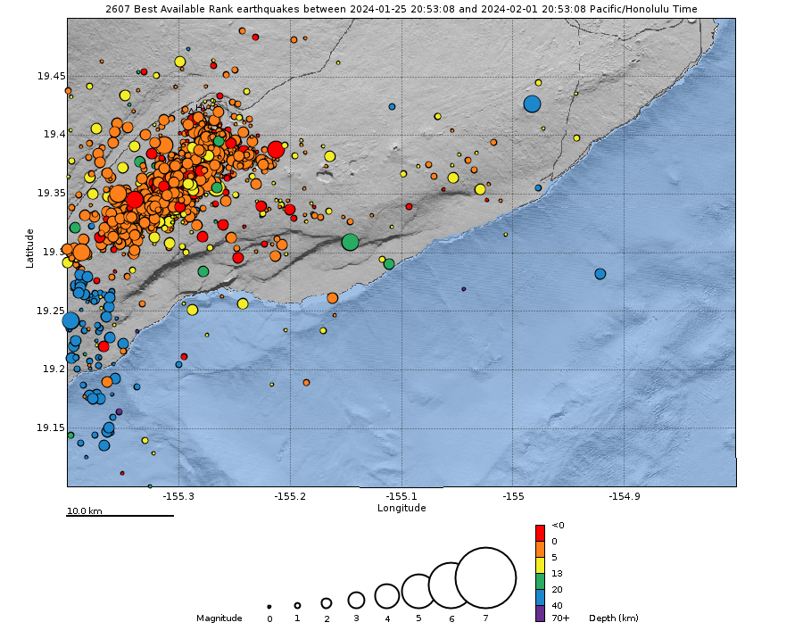
Kīlauea volcano is not erupting. The increase in seismicity and deformation that began early January 31 in the summit region has shifted from the summit to the southwest. Since last night, earthquake activity has concentrated along the Koa‘e fault system southwest of the summit. Kīlauea’s summit remains pressurized; in recent months unrest has escalated quickly, and an eruption could occur in the future with little warning.
Summit Observations:
As of this morning, seismicity in the south caldera region has quieted, and activity is concentrated 5-7 miles (8-11 km) southwest of the caldera, in the vicinity of Pu‘ukoa‘e. Depths have remained consistent, 1–4 km (less than a mile–2.5 mi) below the surface, and the rates have persisted at 25-30 locatable earthquakes per hour. There have been over 70 locatable earthquakes in this region in the past 3 hours, with magnitudes ranging from a maximum of 3 to less than 1. Some events are large enough to be felt by neighboring communities, though none have been large enough to cause damage.
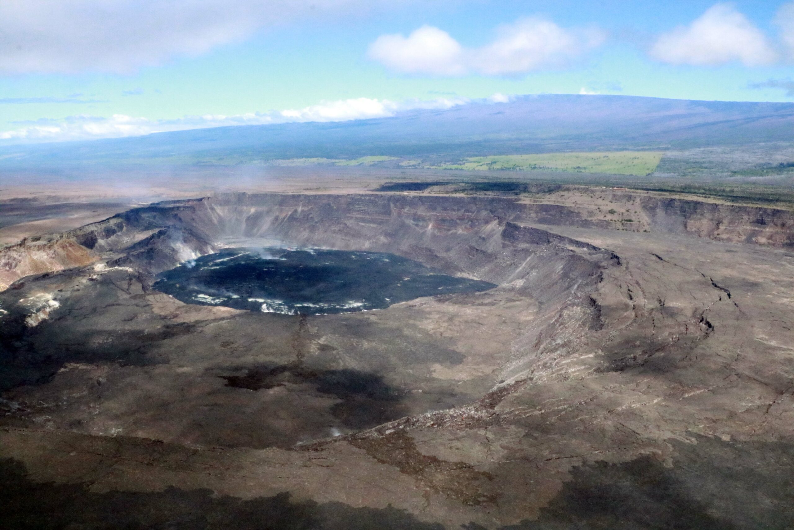
Kīlauea’s summit region remains at a high level of inflation. Nearly 40 microradians of change have been recorded since 4:00 a.m. HST on January 31 at tiltmeters near Sand Hill and Uēkahuna bluff. Both of these tiltmeters showed highly variable directions and rates of tilt on January 31, typical of shallow crack growth that can precede either an eruption or shallow intrusion. Since early this morning, these tiltmeters have shown more consistent directions and rates, suggestive of ground inflation to the southwest (in the direction of where earthquakes are occurring). Step-wise offsets in the tilt signal are likely due to the instrument being shaken by nearby earthquakes or rockfalls.
Sulfur dioxide (SO2) gas emission rates remain low. Field measurements indicated an SO2 emission rate of approximately 70 tonnes per day on January 17, which was similar to measurements in October, November, and early December.
Source : HVO
Photos : USGS , USGS/ K. Mulliken
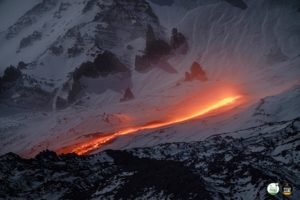
Iceland , Reykjanes Peninsula :
Increased Likelihood of an Eruption.Overall hazard assessment for Grindavík remains unchanged.
Updated 1 Februry 17:00 UTC
Models based on GPS data, reviewed this morning (1 February) by scientists from the Icelandic Meteorological Office and the University of Iceland, indicate that approximately 6.5 million cubic meters of magma has accumulated beneath the Svartsengi region. According to this assessment, magma will soon reach the same volume as drained during the January 2024 eruption. Therefore, the timescale for the next eruption could be within two weeks or possibly days. This means that the likelihood of a magma intrusion, and a volcanic eruption, have increased.
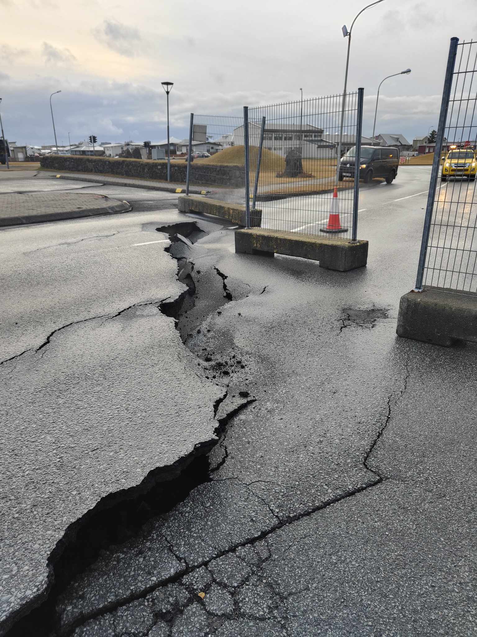
There is no absolute certainty that the warning time ahead of the next intrusion or eruption will be the same as 14 January, which was about a five-hours’ notice from the beginning of the earthquake swarm until the eruption began just south of Hagafell. The warning period for the eruption between Stóra-Skógfell and Sundhnúkur on 18 December last year was about 90 minutes, and that eruption occurred approximately at the mid-point of the (now solidified) magma intrusion beneath the Sundhnúksgígar crater row. With repeated lateral magma intrusions, it is likely that the pathway for magma propagation to the surface will be easier, resulting in less seismicity. However, rapid movements of magma are always accompanied by increased micro-seismicity. We assess that the minimum warning time would be one-hour ahead of a volcanic eruption, and that the most likely pathway would be along the fissures from the magma intrusion on 10 November last year.
Seismic activity has been similar over the past week. Nearly 200 earthquakes have been measured in the area between Stóra-Skógfell and south of Hagafell in the past seven days. Most of these earthquakes were minor, under 1.0 in magnitude, at a depth of 2 to 5 km. The largest earthquake registered magnitude 1.8, and it was located about a kilometre south of Hagafell.
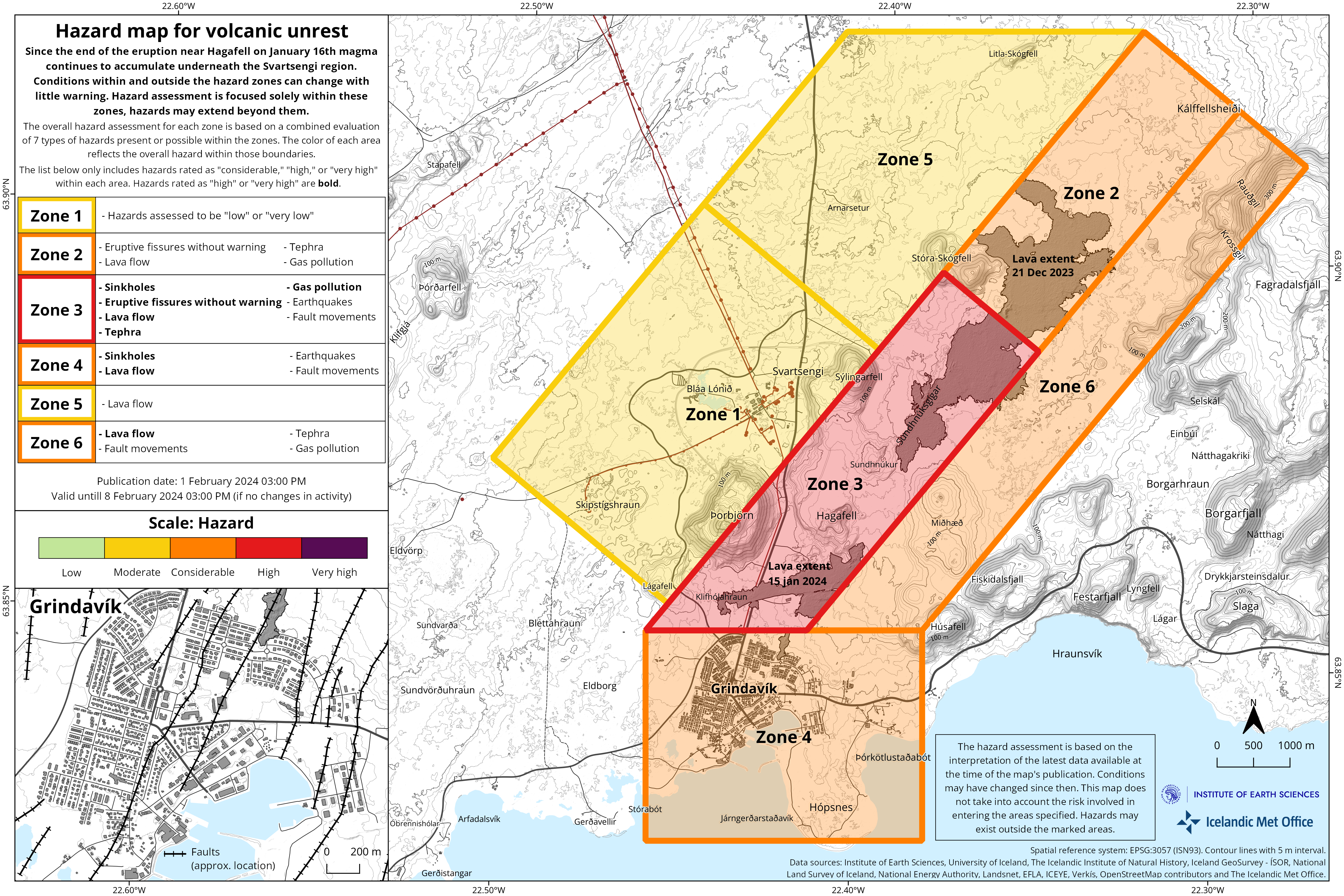
The Icelandic Meteorological Office has issued an updated hazard assessment map. The main changes are that zone 3 (Sýlingarfell – Hagafell) has been upgraded to red (high hazard), and zones 2 and 6 have been upgraded to amber (considerable hazard). Grindavík (zone 4) remains unchanged at a considerable level of hazard.
Source et photo : IMO
New Zealand , Ruapehu :
VOLCANIC ACTIVITY BULLETIN . Fri Feb 2 2024 1:00 PM; Ruapehu Volcano .
Volcanic Alert Level remains at 1
Aviation Colour Code remains at Green
Te Wai ā-moe (Ruapehu Crater Lake) has entered a new heating episode, currently being 29 °C. Other volcanic monitoring indicators remain within normal ranges. Volcanic activity remains low. The Volcanic Alert Level remains at Level 1 and the Aviation Colour Code at Green.
Since mid-October 2023, the temperature of Te Wai ā-moe (Crater Lake) has been slowly increasing (Fig. 1), now reaching 29 ºC marking a new heating episode is under way. The rise has occasionally been impacted by some of the summer rainfall (seen as short, sharp drops in temperature). The heat flow into the lake is currently around 280 MW, typical of when the lake is heating.
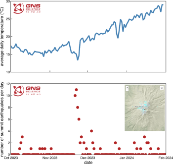
Figure 1: Plot of Te Wai ā-moe (Crater Lake) temperature (top) and number of summit earthquakes per day (bottom – see inset for location) over time.
This new heating episode is accompanied by monitoring trends typically associated with crater lake heating at Mt Ruapehu. Over the last few weeks, the lake colour has changed from a blue green tinge seen when the lake is cooler, to the more common grey colour seen when warm. Minor upwellings are present in the lake and sulphur slicks are present on the lake surface. The lake is overflowing, typical during the summer melt.
The seismic monitoring equipment at Mt Ruapehu has recorded a sequence of small earthquakes at 3-8 km depth clustered under the volcano since late November (Fig. 1). Earthquake size has ranged from M0.3 to M2.4. The level of volcanic tremor has remained weak during the start of this new heating episode.
The scanDOAS gas scanning equipment and gas flights have measured moderate levels of SO2 (sulphur dioxide) gas output as the lake has heated.

The recent earthquakes at moderate depth under the volcano may be in response to a volcanic process like the injection of new magma at depth under the volcano. However, the other monitoring parameters like volcanic tremor, heat flow, gas flow, and lake surface behaviour are all typical of a heating episode in the crater lake, which is being driven by shallower processes. Data observed to date is typical of the past process’s seen in the active hydrothermal system associated with the crater lake.
The change in lake colour is consistent with more gas flow disturbing sediment at the base of the lake, which is now suspended in the lake water. This indicates the vents at the bottom of the lake are at least partially open, allowing hot gas and steam to drive the increase in lake temperature. Volcanic tremor, a key indicator of volcanic fluid movement, remains low and other monitoring indicators are within normal ranges.
Overall, this is consistent with a low level of volcanic activity usually seen during a heating episode. As a result, the Volcanic Alert Level remains at Level 1. The Aviation Colour Code remains Green.
Mt Ruapehu is an active volcano and has the potential to erupt with little or no warning when in a state of minor volcanic unrest.
Source : Geonet
Photo : Bradd Scott / GNS Science
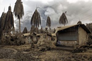
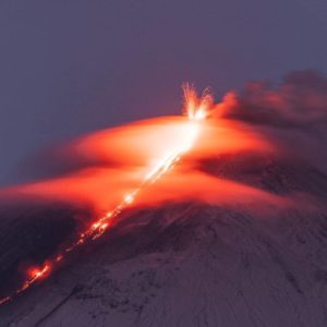
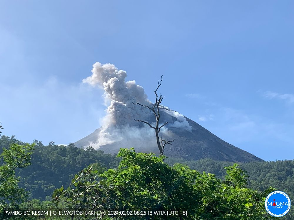
Indonesia , Lewotobi Laki Laki :
An eruption of Mount Lewotobi Laki occurred on Friday, February 2, 2024 at 2:29 p.m. WITA with an ash column height observed at ±1,500 m above the summit (±3,084 m above the level of the sea). The ash column was observed to be white to gray in color with thick intensity, oriented towards the North. This eruption was recorded on a seismograph with a maximum amplitude of 47.3 mm and a duration of 145 seconds.
SEISMICITY OBSERVATIONS
1 eruption earthquake with an amplitude of 47.3 mm and a seismic duration of 145 seconds.
11 avalanche earthquakes with an amplitude of 3.7 to 22.2 mm and an earthquake duration of 27 to 201 seconds.
4 low-frequency earthquakes with an amplitude of 3.7 to 14.8 mm and an earthquake duration of 13 to 26 seconds.
2 deep tectonic earthquakes with an amplitude of 3.7 to 7.4 mm, and duration of the earthquake 70 to 137 seconds.
RECOMMENDATION
– Communities around Mount Lewotobi Laki and visitors/tourists do not carry out any activities within a radius of 4 km around the center of the eruption of Mount Lewotobi Laki and in a sector of 5 km in the North-North-East direction and 6 KM in the North East sector.
– The public should remain calm and follow the instructions of the regional government and not believe rumors whose origin is unclear.
Source et photo : Magma Indonésie .
Alaska , Shishaldin :
54°45’19 » N 163°58’16 » W,
Summit Elevation 9373 ft (2857 m)
Current Volcano Alert Level: ADVISORY
Current Aviation Color Code: YELLOW
Low-level unrest continues at Shishaldin Volcano in the form of small repeating volcanic earthquakes and small explosions as detected by infrasound. These explosions are restricted to the summit crater and are not producing ash emissions. Satellite and webcam views were mostly obscured by clouds over the past day; nothing unusual was observed.
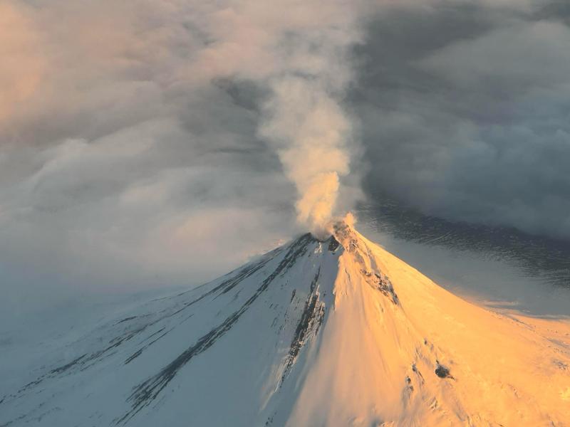
No eruptive activity has been observed since November 2023.
Local seismic and infrasound sensors, web cameras, and a geodetic network are used to monitor Shishaldin Volcano. In addition to the local monitoring network, AVO uses nearby geophysical networks, regional infrasound and lighting data, and satellite images to detect eruptions.
Source : AVO.
Photo : Reedy, Brian