January 27 , 2024 .
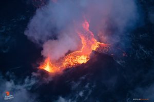
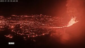
Iceland , Reykjanes Peninsula :
Magma accumulation continues beneath Svartsengi. The hazard associated with fissures within Grindavík remains very high in the updated hazard assessment
Updated 25 January 17:30 UTC
Inflation continues at Svartsengi. Over the past few days, the land has been rising at a rate of approximately 8 mm per day, slightly exceeding the recorded rate of uplift before the eruption on January 14th.
At this point, it is challenging to determine exactly how much magma has accumulated beneath Svartsengi since the eruption ended on January 16th. Most likely, the timeframe required to reach the same volume of magma as before the last eruption will be on the order of weeks, not days. Computational models are being refined to obtain a clearer assessment of the status of magma accumulation.
Low levels of seismic activity persist and are mostly concentrated around Hagafell. The current seismic activity aligns with that observed in the area following the previous eruption.
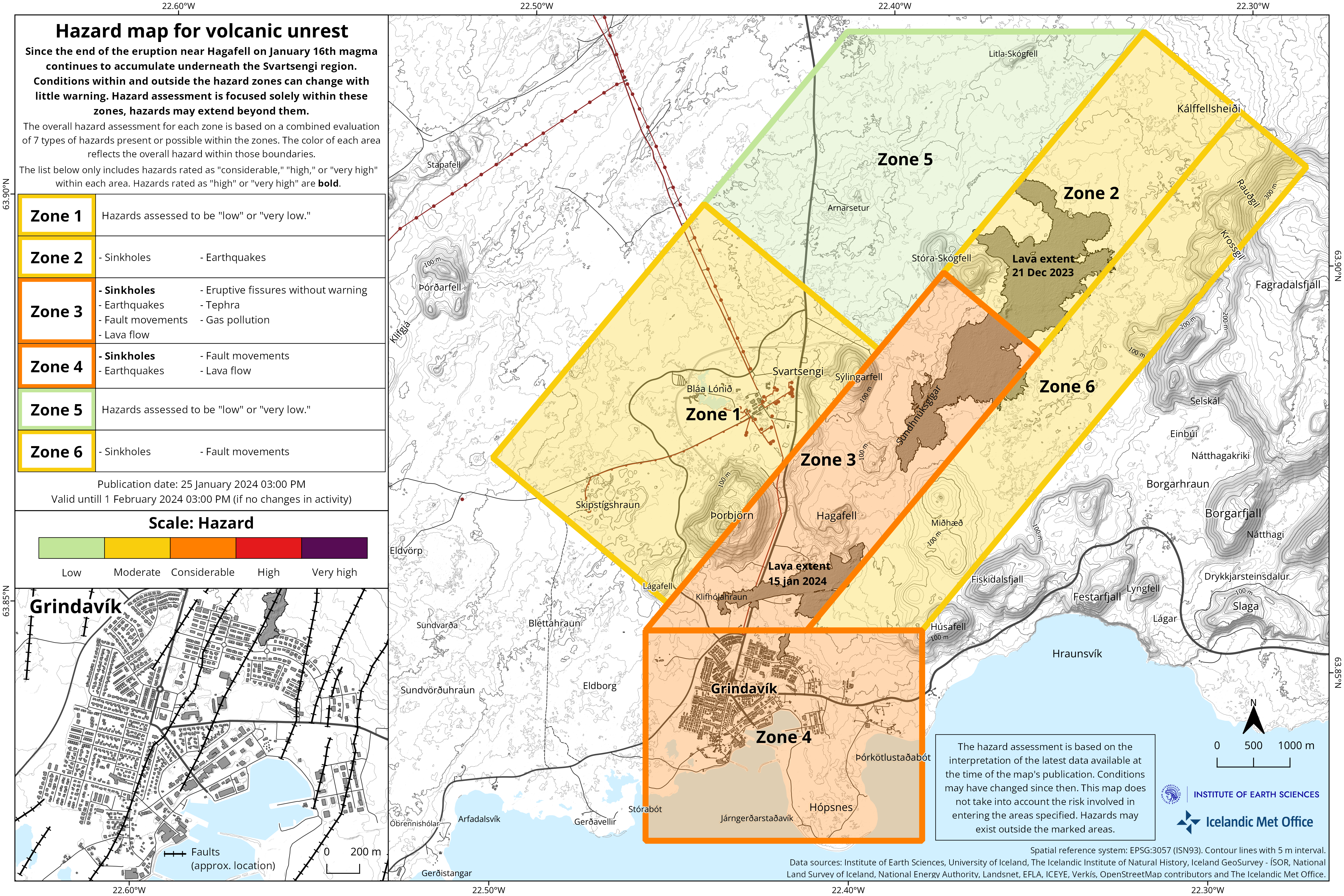
The Icelandic Meteorological Office has issued an updated hazard assessment map. The main changes include reducing the overall hazard level for Grindavík to orange (significant hazard).
It should be noted that, although the overall hazard level for Grindavík has been reduced by one level, the hazard associated with fissures remains very high. The current hazard is now referred to as « subsidence into a fissure, » describing the danger that may be present where fissures are hidden beneath unstable surfaces that could collapse and develop sinkholes.
The hazard assessment related to fissure development within Grindavík has decreased. Evaluations are underway to determine if there is a danger of existing fissures expanding or new fissures forming. GPS data have exhibited very little movement within Grindavík the past few days, reducing the assessed hazard compared to before. The hazard due to sinkholes overlying fissures is now considered significant.
Source et photo : IMO
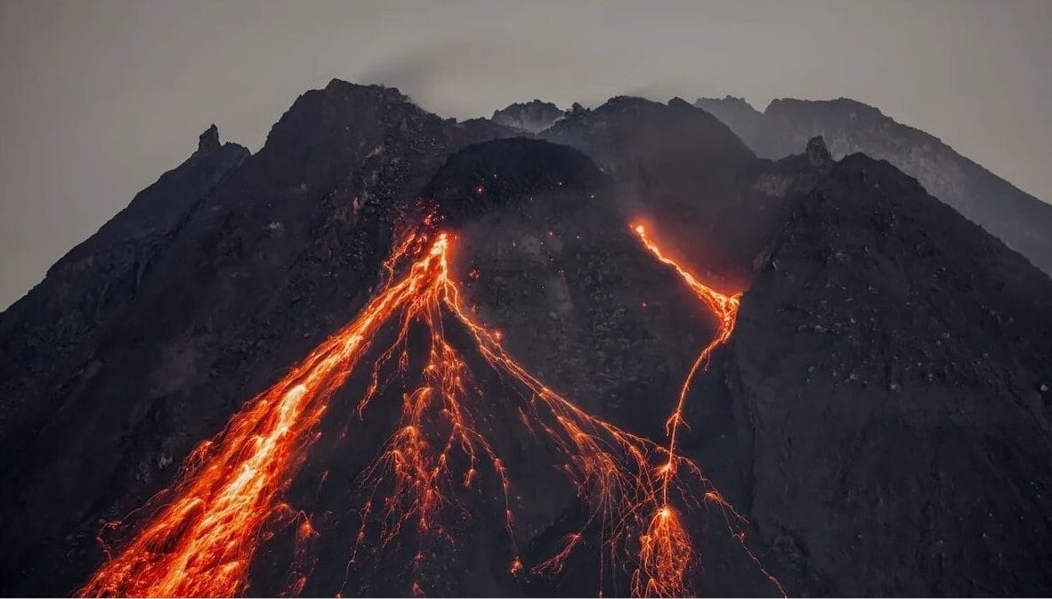
Indonesia , Merapi :
Mount Merapi activity report from January 19 to 25, 2024. Published on January 26, 2024.
Visual
The weather around Mount Merapi is usually sunny in the morning, while daytime until evening is foggy. White smoke, weak to thick, with low to moderate pressure and a height of 300 m is observed from the observation post of Mount Merapi in Ngepos on January 25, 2024 at 09:22 WIB.
This week, 1 eruption with a column height of 1000 m caused ash rain in the subdistrict area of Kemalan, Klaten, Selo, Musuk, Boyolali. 19 hot avalanche clouds descended towards the South West (upstream of the Bebeng River) with a maximum sliding distance of 3000 m. Lava avalanches were observed 47 times in the South and South-West, upstream of the Bebeng River over a maximum distance of 1,500 m. The sound of avalanches was heard 3 times from the Babadan post with low to moderate intensity.
It was observed that the morphology of the southwest dome had changed due to the activity of hot cloud avalanches and lava avalanches. The morphology of the median dome is relatively constant. Based on the analysis of aerial photos from January 10, 2024, the volume of the southwest dome was measured at 2,663,300 m3 and that of the central dome at 2,358,400 m3.
Seismicity
This week the seismicity of Mount Merapi recorded:
1 eruption earthquake
19 warm avalanche cloud (APG) earthquake,
13 shallow volcanic earthquakes (VTB),
84 multi-phase (MP) earthquakes,
798 emissions earthquakes(RF),
6 tectonic earthquakes (TT).
1 low frequency earthquake (LF).
3 tremor type earthquakes
The intensity of earthquakes this week is still quite high.
Deformation
The deformation of Mount Merapi monitored by EDM this week showed a shortening rate of 0.6 cm/day.
Rain and lahars
This week there was rain at Pasarbubar rain station with a rain intensity of 56 mm/hour for 18 minutes at Kaliurang station on January 17, 2024. It was reported that there was an increase in flow of the Gendol river from January 21 to 25, 2024
Conclusion
Based on the results of visual and instrumental observations, it was concluded that:
Mount Merapi’s volcanic activity is still quite high in the form of effusive eruptive activity. The activity status is set to the “SIAGA” level.
Source : BPPTKG
Photo : John Bamforth / FB.
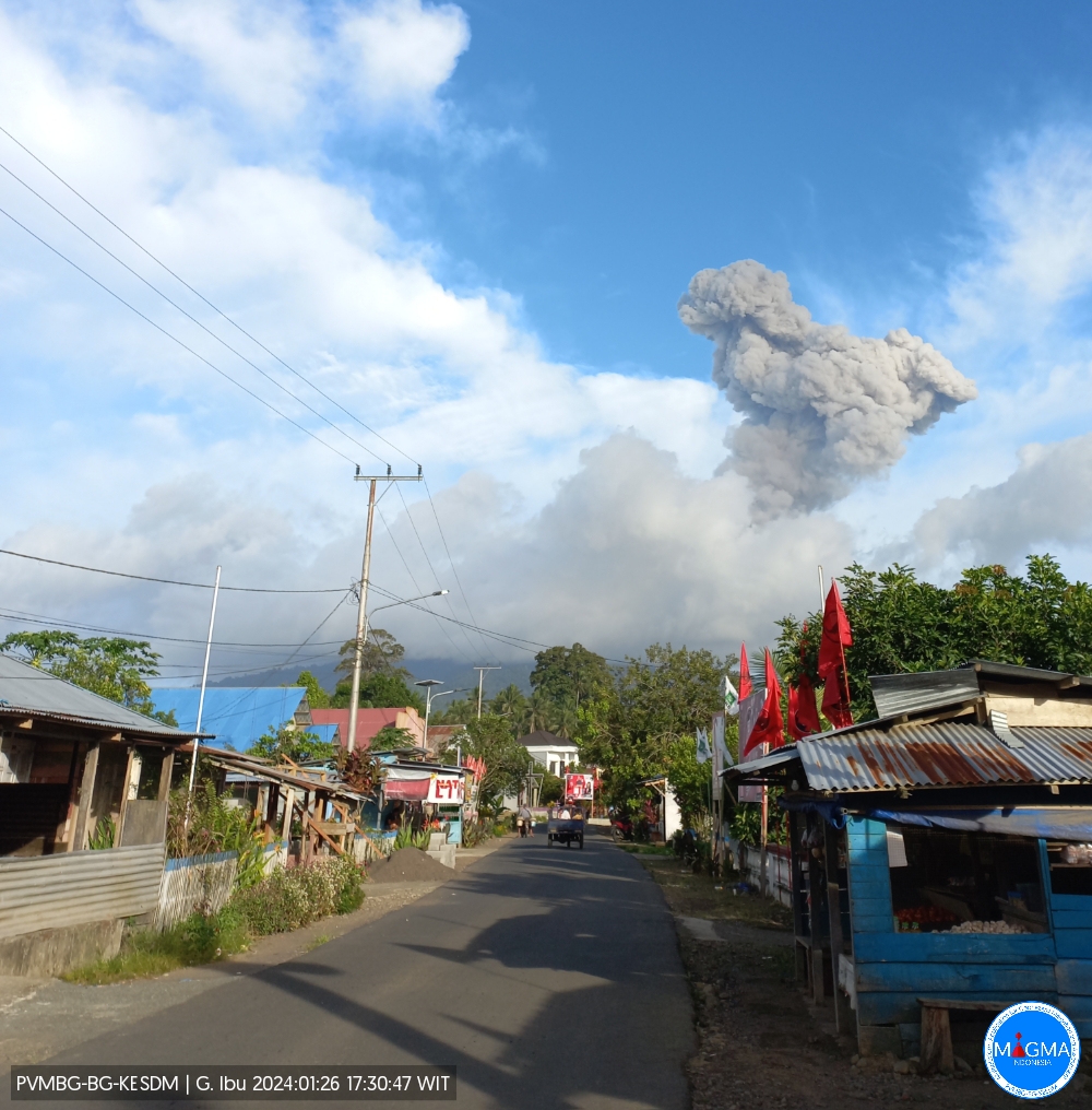
Indonesia , Ibu :
Mount Ibu erupted on Friday January 26, 2024 at 5:27 p.m. WIT. The height of the eruptive column was observed to be ±1,500 m above the summit (±2,825 m above sea level). The ash column was observed to be gray with thick intensity, oriented towards the South and South-West. The eruption was recorded on a seismograph with a maximum amplitude of 28 mm and a duration of 127 seconds.
SEISMICITY OBSERVATIONS
35 eruption earthquakes with an amplitude of 15 to 28 mm and a seismic duration of 26 to 105 seconds.
54 emission earthquakes with an amplitude of 2 to 14 mm and earthquake duration of 15 to 50 seconds.
5 harmonic tremors with an amplitude of 3 to 15 mm and an earthquake duration of 41 to 193 seconds.
264 Shallow volcanic earthquakes with an amplitude of 2 to 14 mm and an earthquake duration of 4 to 14 seconds.
9 deep volcanic earthquakes with an amplitude of 5 to 12 mm, and an earthquake duration of 4 to 8 seconds.
16 distant tectonic earthquakes with an amplitude of 2 to 28 mm, and an earthquake duration of 37 to 134 seconds.
Recommendation
Communities around Mount Ibu and visitors/tourists are advised not to carry out activities within a radius of 2.0 km and a sectoral extension of 3.5 km towards the crater opening in the northern part of the crater active Mount Ibu.
In the event of ash falling, people who practice activities outside the home are advised to wear nasal, oral (mask) and eye (glasses) protection.
Source et photo : Magma Indonésie
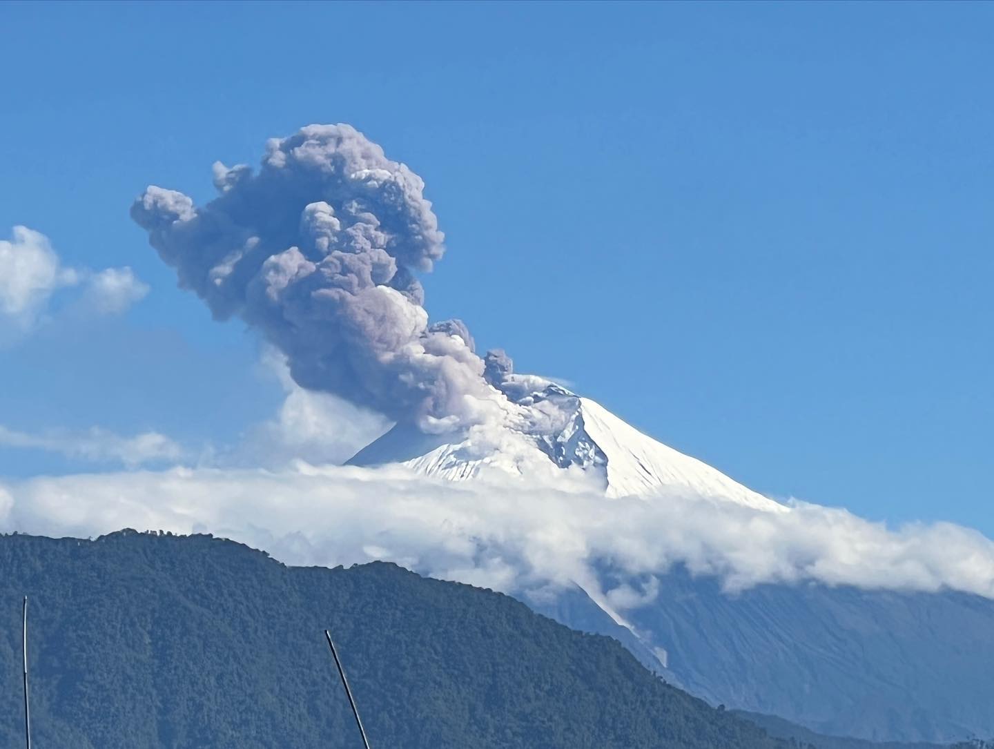
Ecuador , Sangay :
DAILY REPORT ON THE STATE OF THE SANGAY VOLCANO, Friday January 26, 2024.
Information Geophysical Institute – EPN.
Surface activity level: High, Surface trend: No change
Internal activity level: High, Internal trend: No change
Seismicity: From January 25, 2024, 11:00 a.m. to January 26, 2024, 11:00 a.m.:
The number of seismic events recorded at the reference station over the past 24 hours is shown below. The level of seismic activity of the volcano remains high.
Explosion Event (EXP): 378
Precipitation/Lahars:
No rain was recorded in the volcano area. *In the event of heavy rains, these could remobilize the accumulated materials and generate mudflows with debris, which could descend down the sides of the volcano, flowing into adjacent rivers.
Emissions/ash column:
Yesterday evening, thanks to the camera system, an emission of gas and ash could be observed at a height of 300 meters above the level of the crater in the west direction. In addition, the VAAC in Washington published a report reporting an emission at a height of 1,800 meters above the level of the crater in a southwest direction.
Other monitoring parameters:
The FIRMS satellite system recorded 10 thermal anomalies, the MIROVA-MODIS satellite system recorded 1 thermal anomaly and the MIROVA-VIIRS satellite system recorded 3 thermal anomalies in the last 24 hours.
Observation:
The volcano remained cloudy most of the time, so it was not possible to observe any incandescence. At the time of writing, the volcanic area is cloudy.
Alert level: yellow
Source : IGEPN.
Photo : AdriáLou Garay Véle
Guatemala , Santiaguito :
Weather conditions: Partly clear weather.
Wind: North.
Precipitation: 0.0 mm.
Activity:
White fumaroles are observed in a sustained manner from the crater of the Caliente dome which reach 2800 m. Weak, moderate and strong explosions are also generated, accompanied by avalanches mainly on the eastern and southwest flanks, sometimes accompanied by short-distance pyroclastic flows.
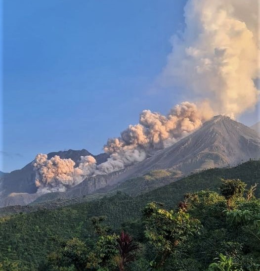
The ash columns are moving west, northwest, about 12 kilometers, falling on the communities of Loma Linda, San Marcos Palajunoj and others in this area. Due to the described activity, longer distance pyroclastic flows may be generated, similar to those in 2022, therefore it is recommended not to approach the areas of the domes, nor to stay near or in the ravines near the volcanic complex. nor to stay close to the southwest lava flow.
Source : Insivumeh
Photo : Edgar Cabrera / CONRED