January 20 , 2024.
Iceland , Reykjanes Peninsula :
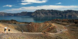
Uplift at Svartsengi continues . Magma most likely no longer flowing into the dyke which formed on January 14 and that the eruption has ended. An updated hazard assessment still estimates that the danger of fissures within Grindavík is high
Updated 19 January 16:30 UTC
Clear signals of a continued land uplift are still being detected beneath Svartsengi. It is yet too early to assert whether the rate of the land uplift has increased since prior to the eruption on January 14. First measurements suggest that is the case, but as has previously been written measurements can fluctuate from one day to the next and a longer timeline of measurement is needed to be able to interpret the long-term development of the land uplift.
Seismic activity continues to decrease in the area of the magma dyke and deformation signals seen on GPS devices suggest significant slow down of ground movement compared to previous days. This information suggest that magma is no longer flowing into the dyke and the eruption has ended.
GPS measurements also show small deformation within Grindavík. There is still high danger of ground collapse into fissures within the town and thus important to map new fissures and changes to known ones estimated.
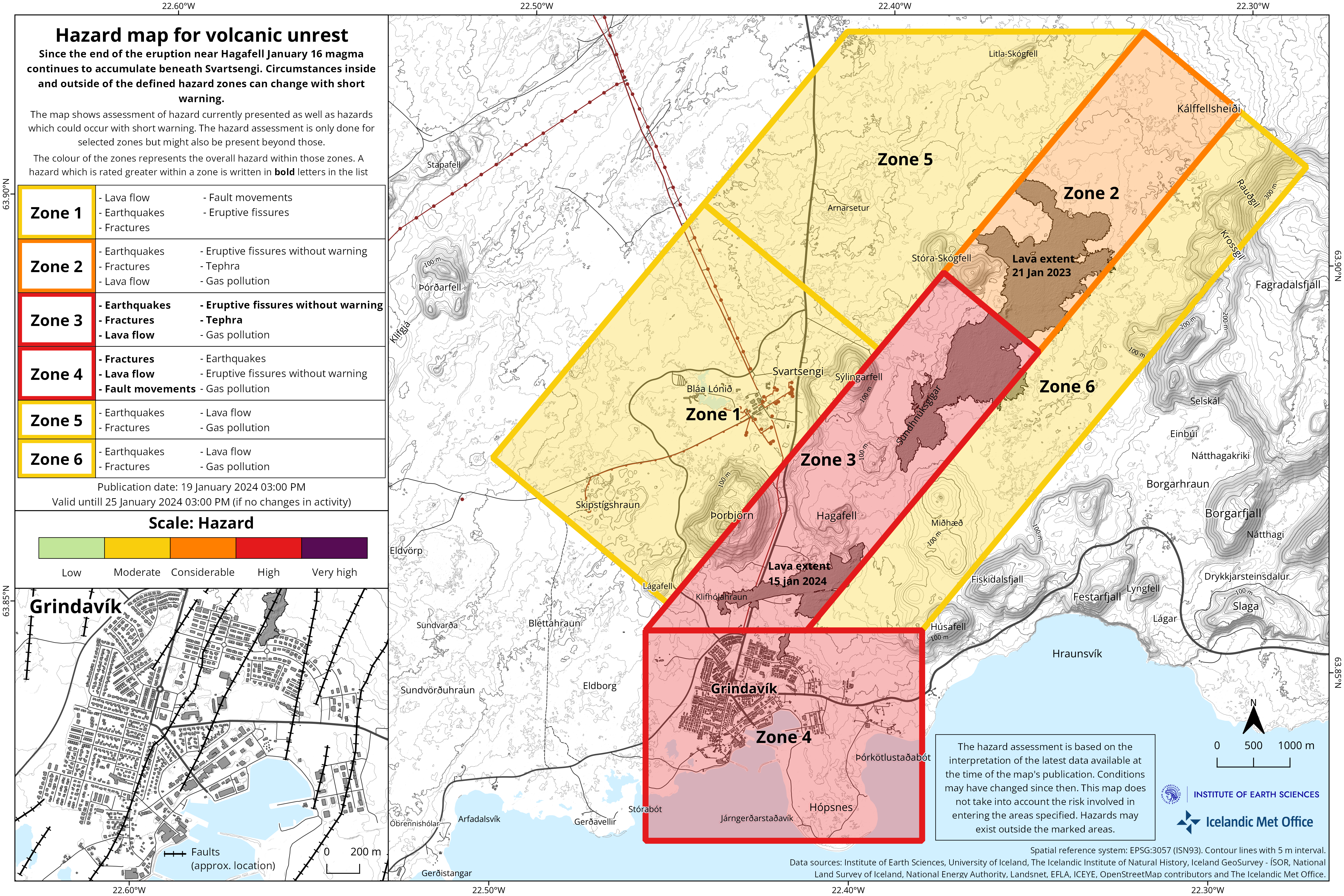
The Icelandic Meteorological Office has updated the hazard assessment due to the volcanic and seismic activity. Hazard level has been decreased in all zones.
An overall hazard assessment for zone 1, Svartsengi, is now down to yellow (moderate hazard).
An overall hazard assessment for zone 4, Grindavík, is now down to red (high hazard). Note that the colour of zones represents the overall hazard within those zones. A hazard which is rated greater within a zone is written in bold letters in the list of hazards on the map.
The the hazard assessmept map takes effect at 15:00 today, Friday January 19 and is valid until Thursday, January 25, at 15:00, unless there are significant developments.
Source et photo : IMO
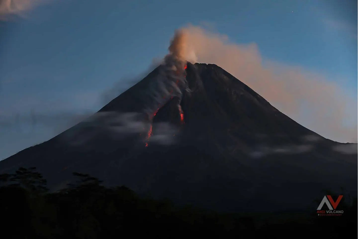
Indonesia , Merapi :
Mount Merapi activity report from January 12 to 18, 2024. Published on January 19, 2024.
Visual
The weather around Mount Merapi is usually sunny in the morning, while daytime until evening is foggy. White smoke, weak to thick, with low to moderate pressure and a height of 75 m is observed from the observation post of Mount Merapi in Kaliurang on January 17, 2024 at 05:30 WIB.
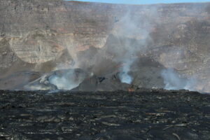
This week, 4 warm avalanche clouds descended towards the South-West (upstream of the Bebeng River) with a maximum sliding distance of 2,400 m. Lava avalanches were observed 88 times in the South and Southwest, including 5 times upstream of the Boyong River over a maximum distance of 1,200 m and 83 times upstream of the Bebeng River over a maximum distance of 1,600 m. mr. The sound of avalanches was heard 9 times from the Babadan post with low to moderate intensity.
It was observed that the morphology of the southwest dome had changed due to the activity of hot cloud avalanches and lava avalanches. The morphology of the median dome is relatively constant. Based on the analysis of aerial photos from January 10, 2024, the volume of the southwest dome was measured at 2,663,300 m3 and that of the central dome at 2,358,400 m3.
Seismicity
This week the seismicity of Mount Merapi recorded:
4 warm avalanche cloud (APG) earthquake,
2 shallow volcanic earthquakes (VTB),
91 multi-phase (MP) earthquakes,
718 emissions earthquakes(RF),
3 tectonic earthquakes (TT).
The intensity of earthquakes this week is still quite high.
Deformation
The deformation of Mount Merapi monitored by EDM this week showed a shortening rate of 0.25 cm/day.
Rain and lahars
This week there was rain at Mount Merapi lookout post with a rain intensity of 59 mm/hour for 90 minutes at Kaliurang lookout post on January 17, 2024. No additional flow or lahar was reported in the rivers that have their source on Mount Merapi.
Conclusion
Based on the results of visual and instrumental observations, it was concluded that:
Volcanic activity at Mount Merapi is still quite high in the form of effusive eruptive activity. The activity status is set to the “SIAGA” level.
Source : BPPTKG
Photo : Andi Volcanist .
Chile , Nevados de Chillan :
Seismology
The seismological activity of the period was characterized by the recording of:
254 seismic events of type VT, associated with the fracturing of rocks (Volcano-Tectonics). The most energetic earthquake had a Local Magnitude (ML) value equal to 2.3, located 2.3 km east-southeast of the volcanic edifice, at a depth of 3.1 km compared to to the crater.
6 LP type seismic events, associated with fluid dynamics inside the volcanic system (Long Period). The size of the largest earthquake evaluated from the Reduced Displacement (RD) parameter was equal to 3 cm2.
4 HB type seismic events, associated with both rock fracturing and fluid dynamics within the volcanic system (Hybrid). The size of the largest earthquake evaluated from the Reduced Displacement (RD) parameter was equal to 57 cm2.
2 VLP type seismic events, associated with the dynamics of large volumes of fluids inside the volcanic system (Very Long Period). The size of the largest earthquake evaluated from the Reduced Displacement (RD) parameter was equal to 3 cm2.
Thermal anomalies by satellites
No thermal anomalies were reported according to mid-infrared volcanic activity observation (MIROVA). Additionally, no radiation anomalies were reported, according to analytical processing of Sentinel 2-L2A satellite images in combination of false color bands.
Geodesy
According to data provided by 4 GNSS stations, installed on the volcanic edifice and which make it possible to monitor its deformation, we observe a low inflationary trend, with rates which do not exceed 0.5 cm/month, considered to be low. at medium magnitude. Horizontal displacements also show stable and small trends, with maximum rates of 0.20 cm/month.
Surveillance cameras
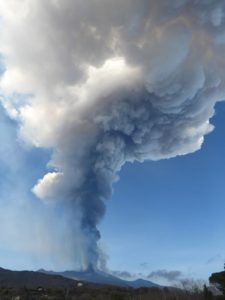
Images provided by the fixed camera, installed near the volcanic complex, recorded passive degassing, with a maximum height reaching 280 m above the crater level on December 5.
Activity remained at levels considered low, suggesting stability of the volcanic system. The technical volcanic alert is maintained in:
GREEN TECHNICAL ALERT: Active volcano with stable behavior – There is no immediate risk
Source : Sernageomin
Photo : REAV Servicio Nacional de Geología y Minería. ( archive).
Colombia , Galeras :
Galeras Volcano Weekly Activity Bulletin
From the monitoring of the activity of the GALERAS VOLCANO, the MINISTRY OF MINES AND ENERGY through the COLOMBIAN GEOLOGICAL SERVICE (SGC) reports that:
In the period between January 9 and 15, 2024, seismicity, both in number and in energy released, remained similar to that recorded last week; however, there has been a slight increase in earthquakes related to the movement of rocks and fluids within the volcano.
The seismicity linked to the fracture of the rock in the volcanic edifice was dispersed over the zone of influence of Galeras, the largest earthquake was 1.3 and was located to the West of the active cone, at a distance of 6.3 km and a depth of 7.2 km. . No earthquakes were reported as felt.
Few gas emissions were observed, which mainly come from the main crater and the “Las Chavas” and “El Paisita” fumarole fields (located respectively to the West and North of the crater).
These emissions had white columns, low outlet pressure, and variable dispersion due to wind action.
Other volcanic monitoring areas showed stability in their recordings.
Volcanic activity remains on YELLOW ALERT Status: Active volcano with changes in baseline behavior of monitored parameters and other manifestations
Source et photo : SGC
Alaska , Shishaldin :
Low-level unrest continued at Shishaldin Volcano over the past week. Frequent, small, low-frequency earthquakes were noted in seismic data, but explosion signals were absent. Weak steam emissions were observed during clear weather in web camera images on January 15 and 18 but were not observed on other clear days. No sulfur dioxide emissions were detected in satellite data. Barely elevated surface temperatures, consistent with cooling deposits, were observed during clear weather. Overall, the level of activity at the volcano appears to be quieting following last year’s eruption, which included 13 significant explosive events from July through November.
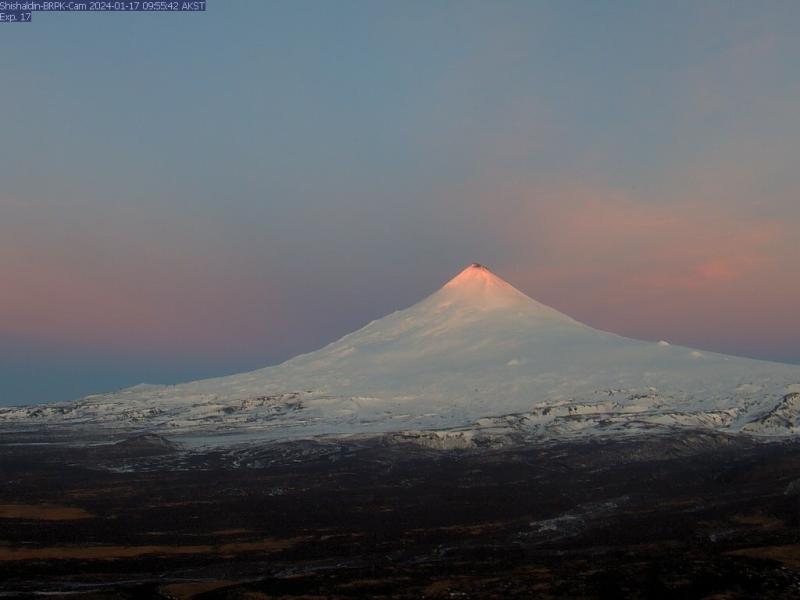
Scenic early morning view at Shishaldin on January 17, 2024. While some bare ground is visible at the summit, no steam emissions are visible on this day.
Local seismic and infrasound sensors, web cameras, and a geodetic network monitor Shishaldin Volcano. In addition to the local monitoring network, AVO uses nearby geophysical networks, regional infrasound and lightning data, and satellite observations to detect eruptions.
Source : AVO
Photo : Lubbers, Jordan