January 15 , 2024.
Iceland , Reykjanes Peninsula :
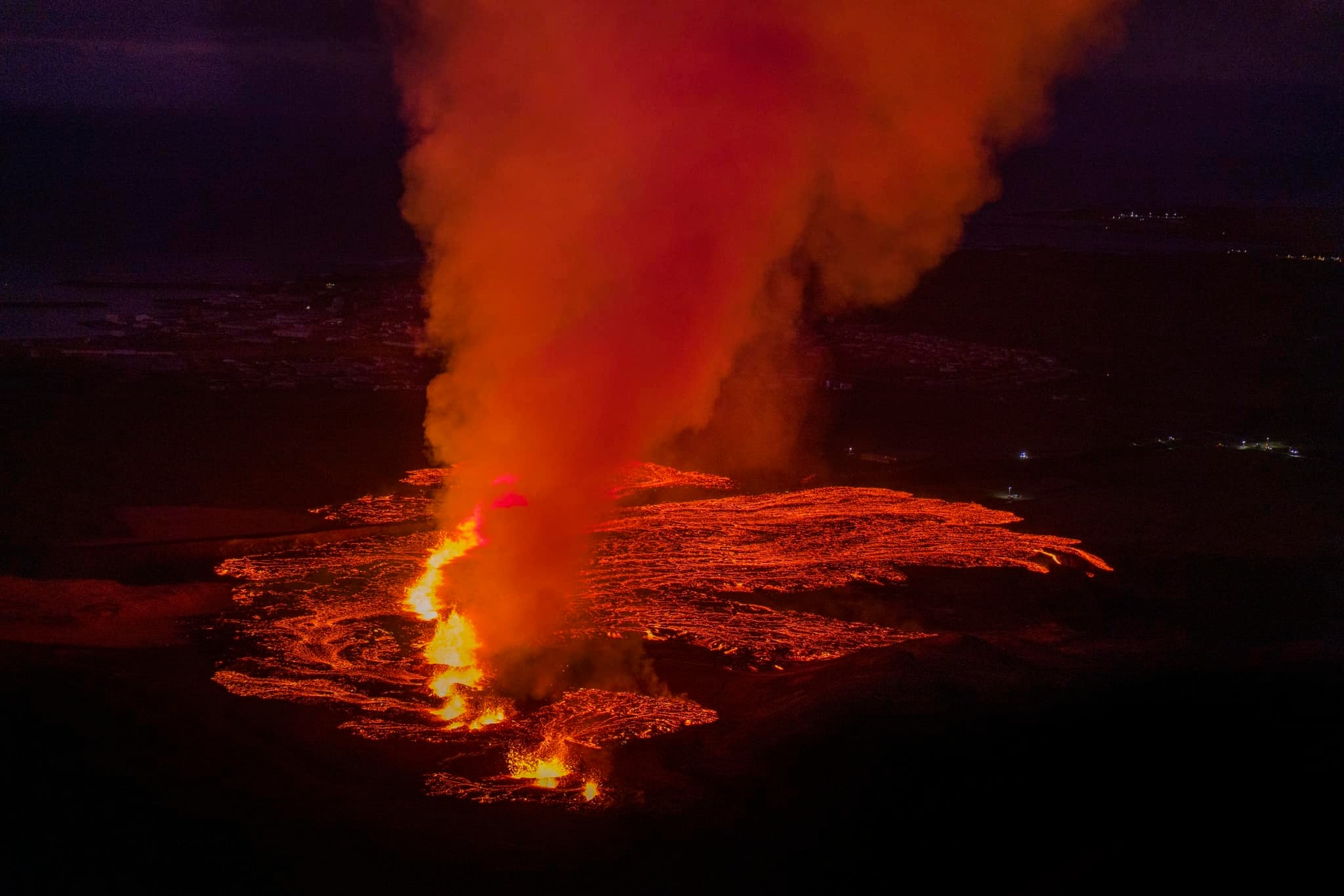
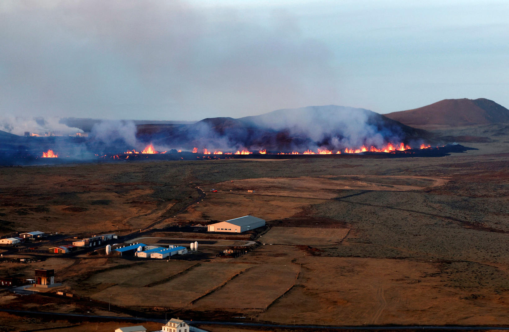
An eruption has started. Updated 14 January at 15:30 UTC
The eruption near Hagafell-Grindavík has maintained the same strength for the past hour or so.
Seismic measurements show that at the beginning of the unrest this morning (~2:30 am), the magma filled dike intrusion initially moved from the SE edge of Stóra-Skógfell and then continued southwest to the southern end of Grindavík. At 5:30 am seismicity had reached the northern end of Grindavík and both seismicity and deformation measurements indicate the dike has since propagated beneath Grindavík town. A new eruptive fissure opened at 12:10 this afternoon, just north of the town. Lava flows extruded from this fissure have now entered the town.
Due to the dike propagation, existing faults and fractures were reactivated and likely new fractures formed within Grindavík.
Gas distribution
The Icelandic Meteorological Office’s weather forecast for gas distribution from the eruption at Hagafell indicates that the direction is north and northeast, with a speed of 3-8 m/s, and the weather is dry and bright today. It will be cloudy at times with minor snowfall late tonight and tomorrow morning. It will clear up in the afternoon tomorrow. Pollution from the eruption is spreading south and southwest.
The fissure which opened north of Grindavík this morning measures 900 meters long and lava flows mainly to the west according to information from the Icelandic Met Office.
A smaller fissure, 100 meters long, opened closer to the town of Grindavík, and is about 200 meters away from the neighborhood of Efrihópur. Lava flows from it in front of the town limits and has already caused serious damage there, with at least three houses burnt and one almost under the lava.
The long fissure is mostly north of the defense walls that have been constructed. They are directed to the west by the lava flow and the lava has covered part of Grindavíkurvegur road and then to the southwest.
New eruption fissure opened up at Grindavík
The magma flowing out of the fissures, lava flow rate and lava size will be better evaluated tomorrow.
It is not possible to rule out that more cracks will form
Along with the formation of the magma dike to the southwest this morning toward and probably beneath Grindavík, there was a large deformation of new fissures and older fissures at the eruption site which occurred on November 10.
When the magma channel was formed last night, deformation was extremely rapid. After the second fissure opened, deformation was significantly reduced and almost stopped, especially at Hagafell and its northernmost point. Deformation is still detected within Grindavík but is decreasing.
The deformation is considered to be a sign that magma pressure is stabilising. However, it is not possible to exclude more eruption fissures.
Sources : IMO , Icelandmonitor.mbl.is/
Photos : RAX-Ragnar Axelsson , mbl.is/Eggert Jóhannesson.
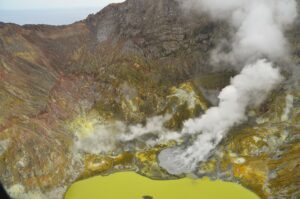
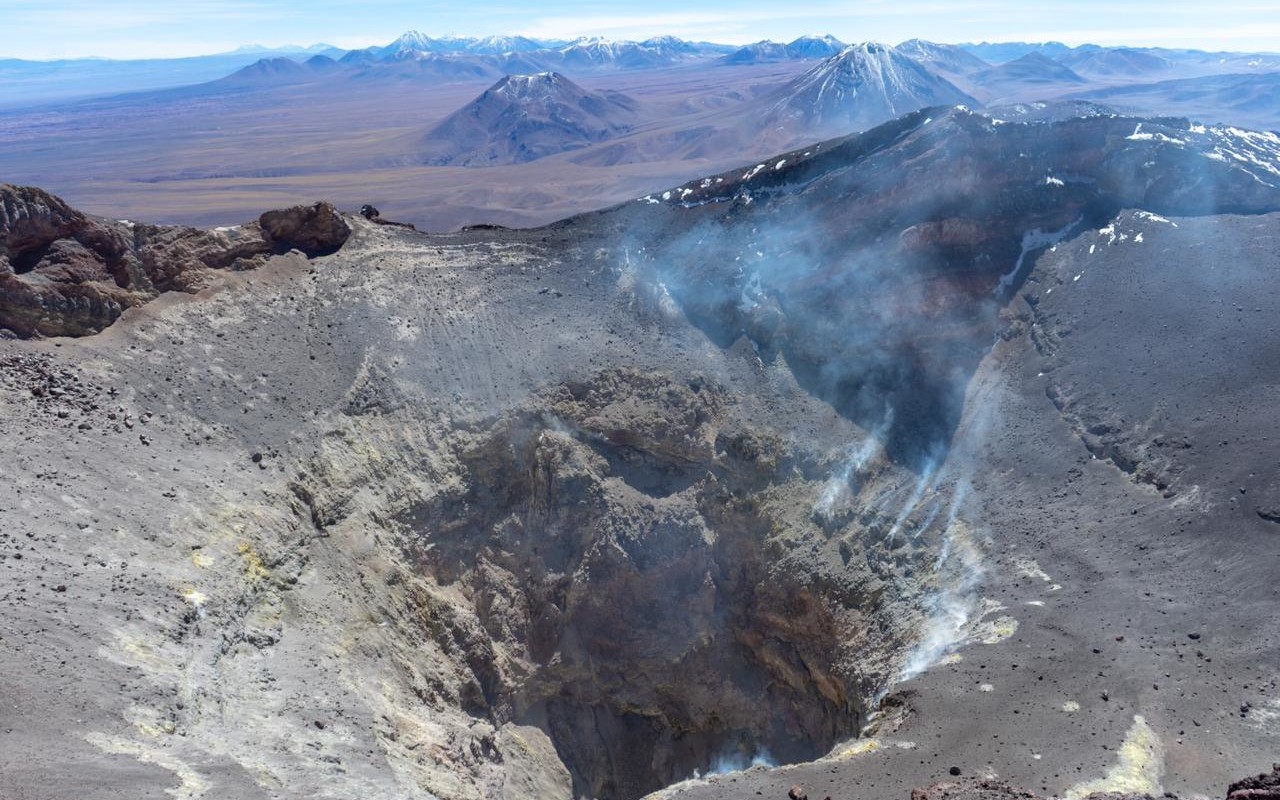
Chile , Lascar :
Seismology
The seismological activity of the period was characterized by the recording of:
26 seismic events of type VT, associated with the fracturing of rocks (Volcano-Tectonics). The most energetic earthquake had a Local Magnitude (ML) value less than 0.1, located 1.2 km south-southeast of the volcanic edifice, at a depth of 3.4 km from the crater .
36 LP type seismic events, associated with fluid dynamics inside the volcanic system (Long Period). The size of the largest earthquake evaluated from the Reduced Displacement (RD) parameter was equal to 15 cm2.
1 TR type seismic event, associated with the dynamics maintained over time of fluids inside the volcanic system (TRemor). The size of the earthquake evaluated from the Reduced Displacement (RD) parameter was equal to 3 cm2.
Fluid geochemistry
The sulfur dioxide (SO2) emissions data obtained by the differential optical absorption spectroscopy (DOAS) equipment, corresponding to the Emú station, located 6 km in the East-South-East (ESE) direction from active crater, presented an average value of 221 ± 67 t/d, with a maximum daily value of 670 t/d on December 21. No anomalies have been reported in emissions of sulfur dioxide (SO2) into the atmosphere in the area near the volcano, according to data published by the Tropopheric Monitoring Instrument (TROPOMI).
Thermal anomalies by satellites
During the period, 13 thermal alerts were recorded in the area associated with the volcanic system, according to data processed by the Middle Infrared Observation of Volcanic Activity (MIROVA), with a maximum power < 1 MW as of December 27. 1 radiance anomaly was reported thanks to the analytical processing of Sentinel 2-L2A satellite images, in
combination of false color bands, for December 26.
Geodesy
The deformation rates of the GNSS equipment installed on the volcano continue to show low deformations, with a maximum of 0.5 cm/month in its vertical component and 0.6 cm/month in its horizontal components, showing no significant change for the period evaluated.
Surveillance cameras
The images provided by the fixed camera, installed near the volcano, recorded regular degassing, with a maximum column height of 1,020 meters on December 25.
Activity remained at levels considered low, suggesting stability of the volcanic system. The technical volcanic alert is maintained in:
GREEN TECHNICAL ALERT: Active volcano with stable behavior – There is no immediate risk.
Source : Sernageomin
Photo : Vulcanopro.
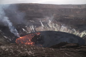
Hawaii , Kilauea :
Sunday, January 14, 2024, 9:01 AM HST (Sunday, January 14, 2024, 19:01 UTC)
19°25’16 » N 155°17’13 » W,
Summit Elevation 4091 ft (1247 m)
Current Volcano Alert Level: ADVISORY
Current Aviation Color Code: YELLOW
Activity Summary:
Kīlauea volcano is not erupting. Over the past day seismicity has been low in the summit region, upper East Rift Zone, and Southwest Rift Zone. Unrest may continue to wax and wane with fluctuating input of magma to the area, and eruptive activity could occur in the near future with little or no warning. No unusual activity has been noted along the middle and lower sections of Kīlauea’s East Rift Zone.

Summit Observations:
Over the past 24 hours, seismicity in Kīlauea’s summit region slightly decreased, with approximately 17 small-magnitude earthquakes (less than M2) recorded beneath the caldera. Seismicity south and southwest of the caldera has decreased since the previous 24 hours. Periods of increased shallow seismicity can be expected to continue during repressurization of the summit magma reservoir, which has been ongoing since the end of the September 2023 eruption. Seismicity has not reached the levels that immediately preceded recent summit eruptions at Kīlauea.
Kīlauea’s summit region remains at a high level of inflation; relative tilt is above the level reached prior to the most recent eruption in September 2023, and it is higher than at any time since the 2018 eruption. Summit tilt at Uēkahuna and Sand Hill tiltmeters showed low magnitude delfation (less than two microradians of total change), indicative of the beginning of a deflation-inflation (DI) event.
Sulfur dioxide (SO2) gas emission rates remain low. Field measurements indicated an SO2 emission rate of approximately 80 tonnes per day on December 28, which was similar to measurements in October, November, and early December.
Source : HVO
Photo : USGS
Ecuador , Reventador :
DAILY REPORT ON THE STATE OF THE REVENTADOR VOLCANO, Sunday January 14, 2024.
Information Geophysical Institute – EPN.
Surface activity level: Moderate, Surface trend: No changes
Internal activity level: Moderate, Internal trend: No changes
Seismicity: From January 13, 2024, 11:00 a.m. to January 14, 2024, 11:00 a.m.:
The following table shows the number of seismic events from the reference station in the last 24 hours.
Explosion (EXP) 41
Long Period (LP) 9
Transmitting tremor (TREMI) 11
Tremor harmonic (TRARM) 3
Precipitation/Lahars:
Rainfall is not recorded. **In the event of heavy rains, these could remobilize the accumulated materials, generating mud and debris flows which would descend the sides of the volcano and flow into adjacent rivers.
Emissions/ash column:
Yesterday evening, the GOES-16 satellite system detected an emission of gas and ash with a column height equal to 800 meters above the level of the crater, in the southwest direction. During this morning, the network of surveillance cameras recorded an emission of gas and ash whose column reached 700 meters above the level of the crater, which moved towards the West. Similarly, the Washington VAAC reported two gas and ash emission alerts with plume heights of 1,100 and 800 meters above the crater level, directed towards the West-Southwest and the South West.
Other monitoring parameters:
Over the past 24 hours, the FIRMS satellite system detected 2 thermal anomalies, while MIROVA-VIIRS recorded 1 thermal anomaly.
Observation:
Since yesterday afternoon until the close of this report, the volcano remains mostly cloudy. However, yesterday evening, thanks to the surveillance camera system, a slight incandescence was observed at the level of the crater.
Alert level: Orange.
Source : IGEPN.
Photo : volcan reventador FB.
Guatemala , Santiaguito :
14°44′ 33˝ North latitude;
91°34’13˝ West longitude.
Altitude: 2,500 meters above sea level.
Weather conditions: Clear weather
Wind: from the West
Precipitation: 0.0 mm.

Activity:
A weak and constant outgassing column is observed above the Caliente dome, with some pulses of increase that allow it to reach up to 500 meters in height. Seismic stations continue to record weak to moderate explosions which generate incandescences and avalanches mainly in the West, South-West and South directions. Moderate explosions form a column of gas and ash up to 3,400 meters above sea level (10,498 feet). The ashes are scattered towards the East. This activity causes the fall of fine ash particles and a foggy environment near the volcano. Strong avalanches and audible noises can be generated several kilometers from the volcanic edifice. The occurrence of block and ash flows of moderate to strong characteristics is not excluded, as well as possible pyroclastic flows over long distances in different directions.
Source : Insivumeh.
Photo : Armando Pineda