November 24 , 2023.
Papua New Guinea , Ulawun :
Rabaul Volcano Observatory (RVO) reported that the eruption at Ulawun continued to intensify in November and culminated in a larger event during 20-21 November. During 3-18 November white gas-and-steam plumes of variable densities rose from the summit crater. Low-level booming noises were reported on 9 November. Crater incandescence was observed nightly and fluctuated between dull and moderately bright; the most intense incandescence was observed during 10-11 November. Seismicity was at low-to-moderate levels and characterized by continuous, low-level volcanic tremors often punctuated by periods of small-to moderate discrete low-frequency volcanic earthquakes that evolved into sub-continuous volcanic tremors.
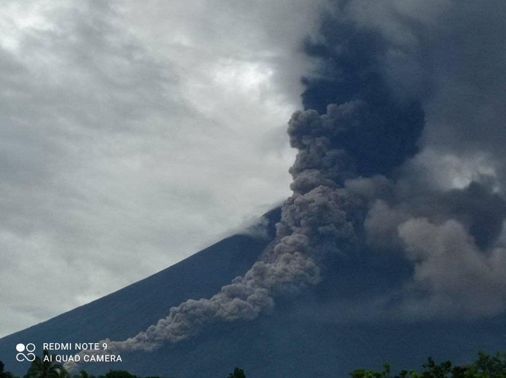
Small ash emissions were observed on 19 November. Seismicity began to intensify at around 02h00 on 20 November and then again at 09h30. The ash emissions increased to moderate levels and eruption noises were heard between 14h30-15h00. The Alert Level was raised to Stage 3 (on the four-level scale). The ash plumes drifted W and NW, causing ashfall in Navo. The eruption significantly intensified during 15h30-16h00 and continued at high levels. According to the Darwin VAAC ash plumes rose as high as 9.1 km (30,000 ft) a.s.l. at 1600 and drifted SW. Ash plumes had risen to 15 km (50,000 ft) a.s.l. by 16h30 and spread almost 65 km W by 17h20.
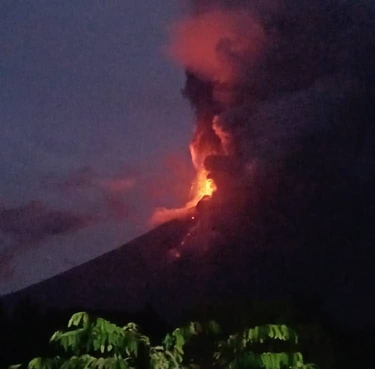
The Alert Level was raised to Stage 4. Continuous ash plumes obscured the summit area and by 18h00 ashfall was reported in the Ulamona Mission area. A photo taken at 18h07 showed incandescent material being ejected above the summit and a dark, dense ash plume rising from the crater. Ashfall was significant in areas to the N and NW and absent in areas to the N and E. Roaring and booming noises continued. Residents of Ubili and Ulamona Mission Station moved to Kabaya and Koasa, and Noau and Voluvolu residents moved to Bakada. Video and photos posted on social media showed tall lava fountaining at the summit and a pyroclastic flow descending the NW flank.
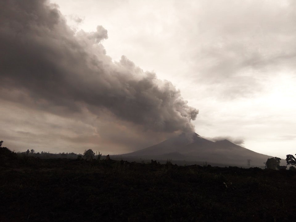
Ash plumes continued to obscure the summit along with darkness from 22h00 on 20 November to 02h00 on 21 November, though the intensity of the eruption had declined. The VAAC continued to report a sustained ash plume rising to 15 km; by 03h20 on 21 November ash had drifted as far as 520 km W. By 04h50 the VAAC noted that ash had reached the stratosphere, rising to 18.2 km (60,000 ft) a.s.l. and drifting 75 km SE; ash at 15 km continued to drift W. Dark, dense ash emissions rose from the summit crater during 02h00-13h00 but were less intense. The Alert Level was lowered to Stage 3, but RVO also noted that at 07h00 one of the two seismic stations had stopped working, making monitoring even more difficult. Low roaring and booming continued, and ash continued to fall mainly to the W and NW, affecting infrastructure and crops. By sunrise the view from the observation post to the summit was blanketed by ash; dense ash obscured views of the summit and flanks. RVO also noted that pyroclastic flows had likely descended the N, and possibly the SE, flanks during the early part of the eruption the day before. The VAAC reported that sustained ash plumes continued, though by 16h30 they were rising to 12.2 km (40,000 ft) a.s.l. and drifting W while the ash at 18.2 km continued to drift E.
During 13h00-14h00 ash emissions significantly decreased, allowing confirmation of a fissure vent on the SW flank at around 1,000-1,400 m elevation about 1 km SE of the 2019 fissure vent. Webcam images suggested that the lava effusion rate from the fissure was high, and that flows had descended possibly to 400 m elevation. Minor incandescent at the summit was visible as well as on the NW flank, possibly from a pyroclastic flow. Several centimeters of ash and scoria had accumulated on rooftops in areas to the N and NW. Minor ashfall was reported in Kimbe. By 22h40 the VAAC stated that the ash at 18.2 km was no longer discernable in satellite images.
RVO reported that during 21h00 on 21 November to 06h00 on 22 November the eruption was at low levels with only minor amounts of ash being emitted, though lava continued to effuse from the fissure. Summit incandescence was no longer visible by 03h19. A few ash puffs were visible during 06h00-08h00 and then the summit was obscured by weather clouds. The Alert Level was lowered to Stage 2.
Sources: Rabaul Volcano Observatory (RVO), Darwin Volcanic Ash Advisory Centre (VAAC), Reuters, Lekei Kilala , GVP.
Photos : Junior Paul Galia , nbc west new britain, Lone Jhahmindz .
Iceland , Reykjanes Peninsula :
Likelihood of a sudden eruption within Grindavík area decreasing daily
Strong indications of a connection between crustal uplift in Svartsengi and the formation of the magma intrusion. It is most likely that magma is rising in the area between Hagafell and Sýlingarfell.
Updated 23. November at 12:30 UTC
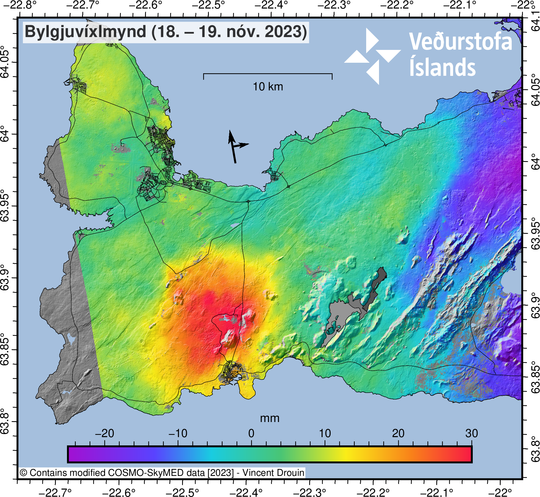
On 21 November, approximately 300 earthquakes were detected in the region of the magma intrusion. From midnight on 22 November to 18:00 UTC on the same day, around 100 earthquakes had been recorded in the same region, which is considerably less than in recent days. Additionally, the intensity of earthquakes above magnitude 2.0 has decreased. During the period of severe weather on 21 and 22 November, efforts were made to assess how weather conditions and ocean swell influences IMO’s monitoring systems.
Magma inflow rates and crustal adjustments related to the formation of the intrusion continue to diminish. Additionally, crustal uplift near to Svartsengi continues at a similar pace. Geodetical models based on data from 21 November suggest that the influx into the intrusion is greatest near to the Sundhnúkur crater row, about 4 km northeast of Grindavík. Minor surface displacements have been detected within the graben region in and around Grindavík.
The likelihood of a volcanic eruption at some location along the length of the magma intrusion persists. It is possible that magma could emerge in the area between Hagafell and Sýlingarfell. However, as crustal relaxation continues to occur and seismicity decreases, along with a decrease in magma inflow to the intrusion, the likelihood of an imminent volcanic eruption diminishes with time.
Based on the latest data, and considering the evolution of activity since 10 November, the likelihood of a sudden eruption within the Grindavík urban area is decreasing daily, and it is presently assessed as low. It can be assumed that newly emplaced magma beneath Grindavík has solidified partially, thereby reducing the likelihood that the magma will reach the surface within the city limits. However, we emphasise that the possibility of a volcanic eruption at some point along the length of the intrusion, particularly between Hagafell and Sýlingarfell, remains plausible.
It is apparent that there is a strong connection between crustal uplift in the Svartsengi region and the sudden, initial propagation of the magma intrusion on 10 November. Models indicate that the magma in the reservoir beneath Svartsengi may have flowed eastward towards the Sundhnúkur craters, subsequently forming the 15-km-long volcanic intrusion. While crustal uplift in Svartsengi continues, it is expected that the accumulating magma may flow again eastwards, potentially reactivating the intrusion. It is also feasible that a magma intrusion could form to the west of the magma body accumulating beneath Svartsengi. Precursors to such an event would include pronounced seismicity and rapid ground displacements, both of which are monitored closely by IMO continuously.
Source et photo : IMO
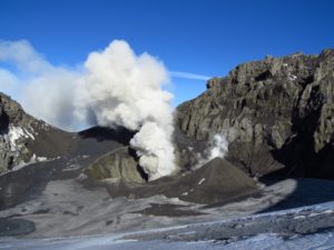
Chile , Laguna del Maule :
Seismology
The seismological activity of the period was characterized by the recording of:
1224 seismic events of type VT, associated with the fracturing of rocks (Volcano-Tectonics). The most energetic earthquake had a Local Magnitude (ML) value equal to 3.8, located 3.5 km South-South-East of the center of the lagoon, at a depth of 9.9 km compared to the average height of the lagoon.
5 LP type seismic events, associated with fluid dynamics inside the volcanic system (Long Period). The size of the largest earthquake evaluated from the Reduced Displacement (RD) parameter was equal to 5 cm2.
Fluid geochemistry
No anomalies have been reported in emissions of sulfur dioxide (SO2) into the atmosphere in the area near the volcanic complex, according to data released by Tropopheric Monitoring Instrument (TROPOMI) and Sulfur Dioxide Instrument Group Ozone Monitoring System (IMO).
Thermal anomalies by satellites
During the period, no thermal alerts were recorded in the area associated with the volcanic complex, according to the analytical processing of Sentinel 2-L2A satellite images, in combination of false color bands.
Geodesy
The geodetic activity of the period was characterized by:
– Monitoring of monitoring lines (distance between GNSS stations) similar to previous periods and with medium to high magnitudes (0.6 cm/month).
– Deformation rates, observed from InSar, with values very close to what has been observed historically in the complex.
Therefore, based on the geodetic data obtained during the period, displacements similar to previous periods (monitoring lines) are observed, in accordance with the inflationary process recorded since 2012 by the Ovdas deformation monitoring network.
The volcanic complex continues to show activity with the generation of mainly volcano-tectonic earthquakes, located mainly in the area located to the South-East of the lagoon and in the Nieblas area, to the South-South-West of the lagoon. Furthermore, the process of cortical deformation remains active with uplift rates lower than the historically recorded average. These conditions allow us to deduce that the volcanic system is still above its base threshold, the technical alert is therefore maintained with a potential danger zone of 2 km around the CO2 anomaly.
YELLOW TECHNICAL ALERT: Changes in the behavior of volcanic activity
Observation: The area concerned is considered to be that contained within a radius of 2 km around the passive CO2 degassing zone.
Source et photo : Sernageomin
Italy / Sicily , Etna :
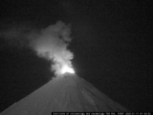
Communication on the activity of Etna, November 24, 2023, 05:22 (04:22 UTC).
The National Institute of Geophysics and Volcanology, Osservatorio Etneo, communicates that from the analysis of images from the surveillance camera network, an increase in Strombolian explosive activity at the Southeast crater has been observed since 3:36 a.m. UTC. The volcanic ash dispersion forecast model indicates a probable dispersion of the volcanic plume in a north-northwest direction.
The mean amplitude of the volcanic tremor has a discontinuous trend with rapid and broad oscillations between medium and high values. The sources are located in the Southeast crater area. Infrasound activity is localized in the Southeast crater area with medium-high intensity events.
Concerning ground deformations, the inclinometer network does not detect significant variations.
Further updates will be communicated shortly.
Source et photo : INGV.
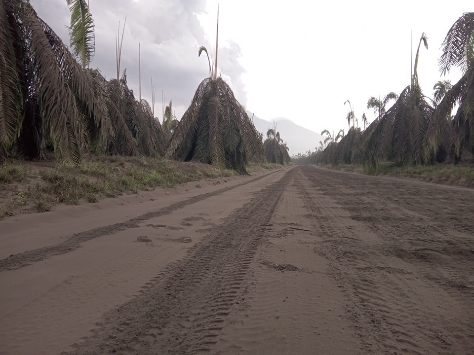
Guatemala , Santiaguito :
Weather conditions: Clear weather.
Wind: East.
Precipitation: 1.8 mm.
Activity:
The Santa María-Santiaguito Volcanic Complex Observatory reports activity in the Caliente dome, with low to moderate outgassing of water vapor and other magmatic gases rising 300 meters above the Caliente dome. During the night and early morning, incandescence was observed in the dome and on the sides of the dome following the explosions. Small and moderate explosions occur at a rate of 1 to 2 per hour, accompanied by low rumbling sounds, raising columns of water vapor and ash to heights of 700 meters above the dome.
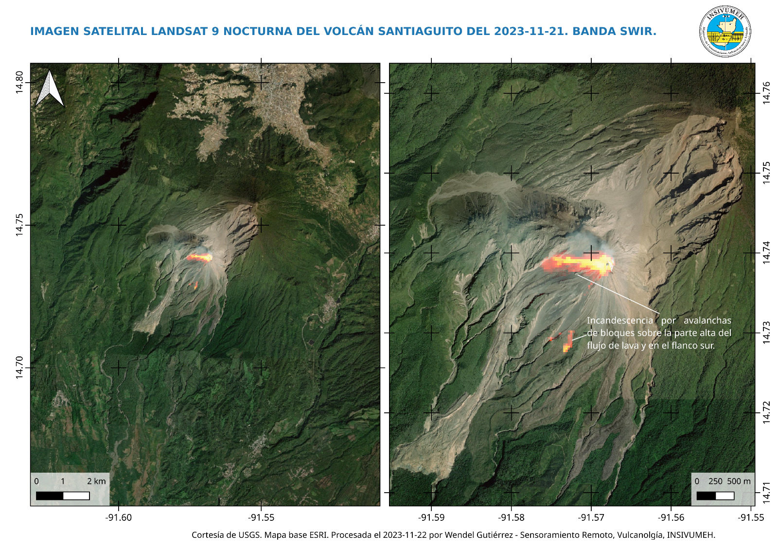
These bring down flows of blocks and ashes mainly towards the south and south-west flanks of the Caliente dome, leaving its well-marked descent channels, some of which almost reach the base of the dome. The descent of these flows produces faint noises perceptible in areas close to the domes. Detachment of boulders from the dome and occasional lava flows continue. The west and northwest wind can cause ash falls on San Marcos Palajunoj and Loma Linda. Activity remains at a high level, so there remains the possibility that with explosions or under the effect of gravity, part of the accumulated materials will collapse and long-distance pyroclastic flows will be generated towards the South. West, South and South-East. In the afternoon, rains may bring down lahars through the Cabello de Ángel and Nimá I channels, as well as at El Tambor.
Source : Insivumeh
Photo : Landsat / USGS