October 25 , 2023.
Italy , Stromboli :
WEEKLY BULLETIN, from October 16, 2023 to October 22, 2023, (publication date October 24, 2023)
SUMMARY STATEMENT OF ACTIVITY
In light of the monitoring data, it appears:
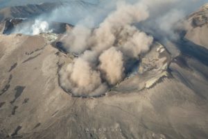
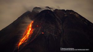
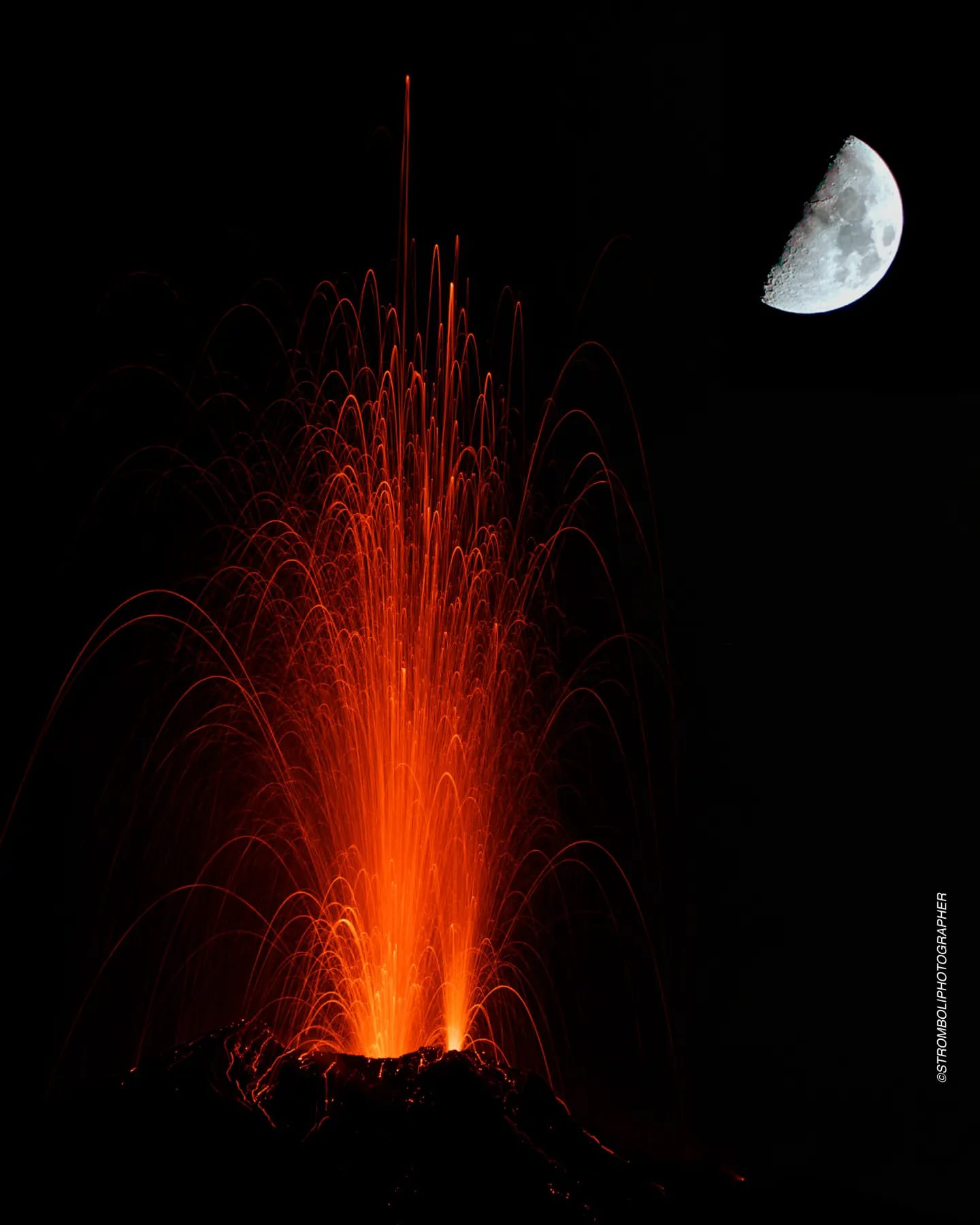
1) VOLCANOLOGICAL OBSERVATIONS: Normal Strombolian activity was observed during this period. The total hourly frequency fluctuated between average values (9-13 events/h). The intensity of the explosions varied from low to medium in the North Crater area and from low to high in the South-Central area.
2) SISMOLOGY: The monitored seismological parameters do not show significant variations.
3) GROUND DEFORMATIONS: The island’s ground deformation monitoring networks did not show significant variations during the period studied. There is a variation of approximately 2 microradians on October 20 at the TDF inclinometer station lasting approximately 30 minutes.
4) GEOCHEMISTRY: SO2 flux at an average and decreasing level
Soil CO2 flux on Pizzo (STR02) and Scari (STR01) without significant variations.
The C/S ratio in the plume increases
There is no update on the isotope ratio of helium in groundwater.
5) SATELLITE OBSERVATIONS: Thermal activity observed by satellite was generally low level with rare and isolated anomalies of moderate level.
VOLCANOLOGICAL OBSERVATIONS
In the observed period, the eruptive activity of Stromboli was characterized through the analysis of images recorded by the INGV-OE surveillance cameras at altitude 190m (SCT-SCV), from
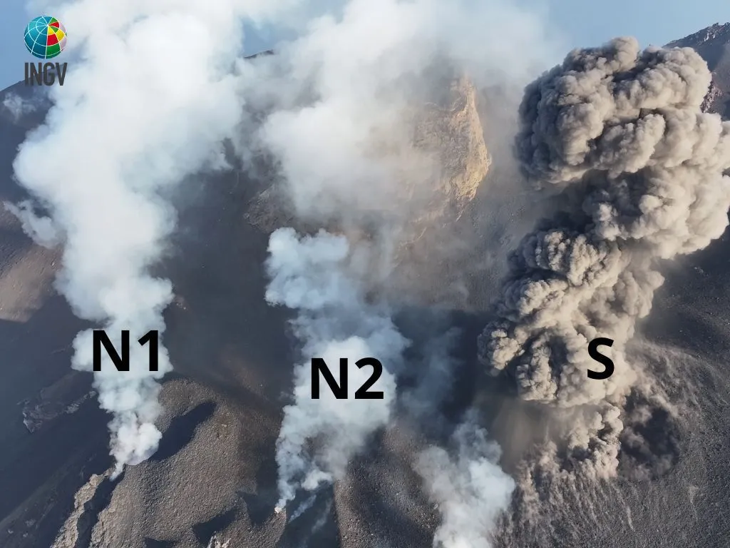
Pizzo and Punta dei Corvi. The explosive activity was mainly produced by 4 (four) eruptive vents located in the northern area of the crater and by 3 (three) vents located in the south central area.
Due to the technical failure that occurred from 9:31 p.m. UTC on October 12, 2023, the cameras at altitude 190m (SCT and SCV) and the duPizzo camera (SPT) resumed transmitting images from the crater terrace on October 17 from 11:43 UTC.
Observations of explosive activity captured by surveillance cameras.
In the area of the North crater (N), with two vents located in sector N1 and one in sector N2, explosive activity of varying intensity from low (less than 80 m high) to medium (less than 150 m high). top) was observed. The products emitted in the eruption were mainly coarse materials (bombs and lapilli) sometimes mixed with fine materials (ashes). The average frequency of explosions oscillated between 3 and 6 events/h.
In the South-Central (CS) zone, sectors S1 and C did not show significant activity while sector S2, with two vents also active at the same time, showed explosive activity of varying intensity of low to high (more than 150 m high) consisting mainly of fine materials mixed with coarse materials.
The average frequency of explosions fluctuated between 5 and 8 events/h.
Field observations also with the use of drones on October 18 and 22.
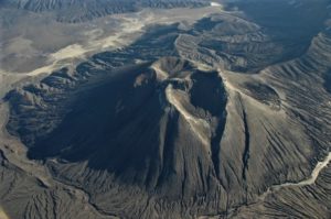
As part of the activities envisaged by the UN departmental project, observations of eruptive activity were carried out from the summit area of Stromboli on October 18 and 22. From a morphological point of view and compared to the observations made in September (see weekly bulletins n°37 and 38), the Centre-South zone appears profoundly modified. The intense activity of recent weeks has in fact formed a cone around the vents of sector S2, while the vents and hornitos of sector C are no longer visible, which appeared covered and filled with abundant explosive products.
Below is the observed eruptive activity, distributed by sectors:
N1: intense explosions with emission of coarse material from the main cone, almost always followed by a vertical jet coming from the secondary vent located on the external face of the cone. The explosions were usually accompanied by loud explosions.
N2: at least one vent presenting intense but infrequent explosions linked to violent gas emissions; no obvious release of volcanic material was observed.
C: total absence of degassing.
S1: the small hornito observed in September was replaced by a small vent characterized by modest but continuous degassing.
S2: inside the cone there are at least 4 vents, the most active of which were in the westernmost part and produced abundant emissions of ash associated with relatively rare coarser materials (incandescent bombs and blocks lithic). Two other secondary vents were positioned in the easternmost part and were characterized by secondary ash emissions which generally occurred immediately after the activation of the first 2 vents.
Furthermore, as part of the activities provided for by the DPC-INGV Convention all. A, and UNO and Dynamo projects, on October 18, observations of volcanic activity and the morpho-structural structure of the crater terrace were carried out using drones.
Source : INGV
Photos :Stromboli stati d’animo / sebastiani Cannavo ,Tullio Ricci.
Hawaii , Kilauea :
Monday, October 23, 2023, 8:01 PM HST (Tuesday, October 24, 2023, 06:01 UTC)
19°25’16 » N 155°17’13 » W,
Summit Elevation 4091 ft (1247 m)
Current Volcano Alert Level: ADVISORY
Current Aviation Color Code: YELLOW
KĪLAUEA INFORMATION STATEMENT
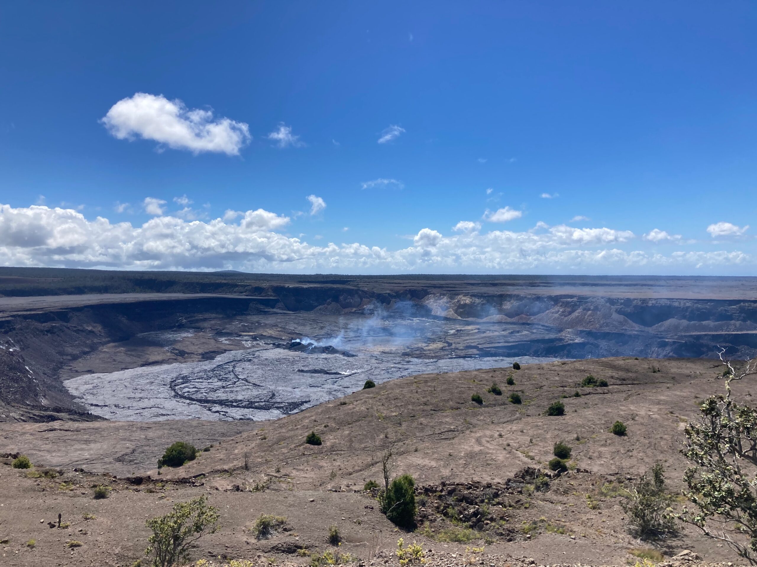
Kīlauea volcano is not erupting. Elevated unrest to the south-southwest of Kīlauea’s summit has continued over the past 24 hours in association with an intrusive event that began in early October. Tremor was observed on seismic stations nearly island-wide today, from approximately 2:20 p.m. to 3:00 p.m., and was strongest at Kīlauea summit. No significant changes in ground tilt were observed during this tremor event. Unrest may continue to wax and wane with changes to the input of magma into the area. The summit of Kīlauea remains at a high level of inflation and eruptive activity at the summit is possible with little or no warning. No unusual activity has been noted along Kīlauea’s East Rift Zone or Southwest Rift Zone. The current Volcano Alert Level remains at ADVISORY. The current Aviation Color Code remains at YELLOW. This update summarizes recent observations and outlines possible scenarios.
RECENT OBSERVATIONS
The most recent eruption at Kīlauea summit ended on September 16, 2023. Following this eruption, seismicity and ground deformation remained at background levels until the first week of October. Rates of ground deformation then began to increase, especially in the region extending from the south caldera to the Koa‘e fault zone. A series of seismic swarms began in this region on October 4, 2023, peaking at more than 250 earthquakes on October 5. Magma did not reach the surface, and rates of seismicity and deformation diminished after October 5, suggesting an intrusion. Unrest has continued to wax and wane since then.
Overall inflationary ground deformation has continued intermittently with days-long periods of increased rates alternating with days-long periods of little or no ground deformation. In total, approximately 120 microradians of change have been recorded by the Sandhill (SDH) tiltmeter over the past three weeks. (Note: the SDH tiltmeter went offline on October 9 due to instrument maintenance and was reset; an offset was estimated from other geophysical measurements and added to the SDH time series to approximate deformation during this outage.) GPS and satellite radar data confirm that over 10 cm (4 inches) of inflation has occurred in this region since late September. At Kīlauea’s summit, the Uēkahuna (UWE) tiltmeter has shown more persistent but slower inflation, with approximately 20 microradians of change over the past three weeks.
Since October 5, intermittent seismic swarms have continued, varying from less than 20 events per day to more than 150 events on October 22. Generally, higher numbers of earthquakes coincided with times when the SDH tiltmeter showed increased rates of inflationary ground motion, from October 3-6, 16-18, and 21-23. Most of the earthquakes related to this unrest have been smaller than magnitude-2 and have occurred at depths of around 1–3 km (0.6–2 mi) below the surface. Seismic signals indicating magma movement, such as low-frequency tremor, have also been observed at Kīlauea summit stations, most recently on the afternoon of October 23, 2023.
Source : HVO
Photo : USGS/ M. Patrick.
Alaska , Bogoslof :
AVO/USGS Volcanic Activity Notice
Current Volcano Alert Level: ADVISORY
Previous Volcano Alert Level: UNASSIGNED
Current Aviation Color Code: YELLOW
Previous Aviation Color Code: UNASSIGNED
Issued: Tuesday, October 24, 2023, 2:55 PM AKDT
Source: Alaska Volcano Observatory
Notice Number: 2023/A1535
Location: N 53 deg 55 min W 168 deg 2 min
Elevation: 492 ft (150 m)
Area: Aleutians
Volcanic Activity Summary:
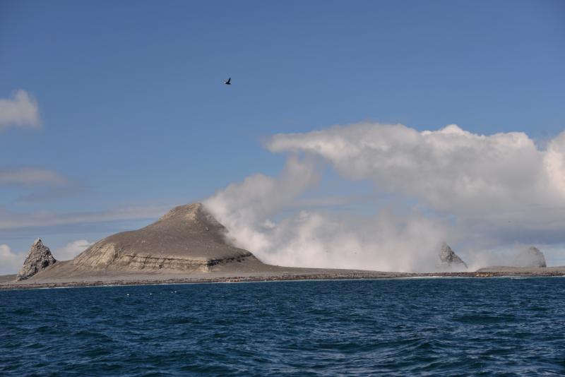
Over the past three days, over 90 earthquakes have been detected in the vicinity of Bogoslof volcano. This marks a change in behavior and the Aviation Color Code and Volcano Alert Level is being increased to YELLOW/ADVISORY. Increases in seismic activity typically precede eruptions, but many volcanoes have exhibited similar behavior that did not result in eruptions. There have been no other signs of unrest observed in satellite data over the past several days.
Bogoslof volcano is monitored using a single local seismic station, distant seismic and infrasound instruments, satellite data and lightning detection. At least nine historical eruptions have been documented at Bogoslof volcano. The most recent occurred from December 2016 to August 2017 and produced seventy main explosive events that generated volcanic ash clouds that rose as high as 13 km (42,500 ft) above sea level, and that greatly modified the topography of Bogoslof Island.
Remarks:
Bogoslof volcano is located about 98 km (61 mi) northwest of Unalaska/Dutch Harbor, 123 km (76 mi) northeast of Nikolski, and 149 km (93 mi) northeast of Akutan. It is within the U.S. Fish and Wildlife Service Alaska Maritime National Wildlife Refuge and is habitat for marine mammals and seabirds
Source : AVO
Photo : Read, Cyrus / Alaska Volcano Observatory / U.S. Geological Survey.
Colombia , Nevado del Huilà :
Popayan, October 24, 2023, 3:30 p.m.
Weekly bulletin on the activity of the Nevado del Huila volcano
From the monitoring of the activity of the NEVADO DEL HUILA VOLCANO, the MINISTRY OF MINES AND ENERGY, through the COLOMBIAN GEOLOGICAL SERVICE (SGC), reports that:
In the week from October 17 to 23, 2023, seismic activity presented a significant increase mainly associated with fracture processes, where the events presented on October 21 stand out, located under the central peak of the Nevado de Huila volcano and which reached local magnitudes up to 3.6 ML
Images obtained using installed cameras showed degassing of the volcanic system. The other parameters measured for the diagnosis of volcanic activity did not show significant changes.
During the period evaluated, the volcano continued to exhibit stable behavior.
The alert status for volcanic activity remains at: YELLOW ALERT: ACTIVE VOLCANO WITH CHANGES IN PARAMETER BASE LEVEL BEHAVIOR
SURVEILLANCE AND OTHER DEMONSTRATIONS.
The COLOMBIAN GEOLOGICAL SERVICE will continue to monitor the evolution of the volcanic phenomenon and will inform in a timely manner of any changes that may occur.
Source : SGC
Photo : Parque-Nacional-
Kamchatka , Klyuchevskoy :
VOLCANO OBSERVATORY NOTICE FOR AVIATION (VONA)
Issued: October 25 , 2023.
Volcano: Klyuchevskoy (CAVW #300260)
Current aviation colour code: ORANGE
Previous aviation colour code: orange
Source: KVERT
Notice Number: 2023-126
Volcano Location: N 56 deg 3 min E 160 deg 38 min
Area: Kamchatka, Russia
Summit Elevation: 4750 m (15580 ft)
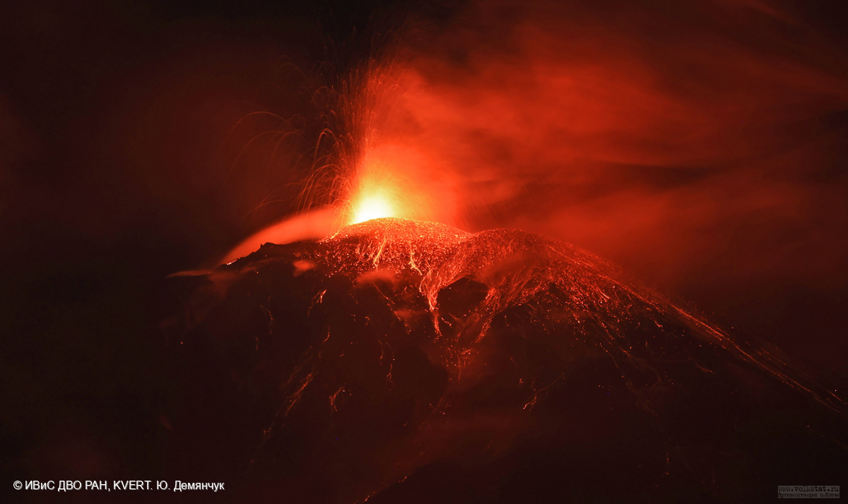
Volcanic Activity Summary:
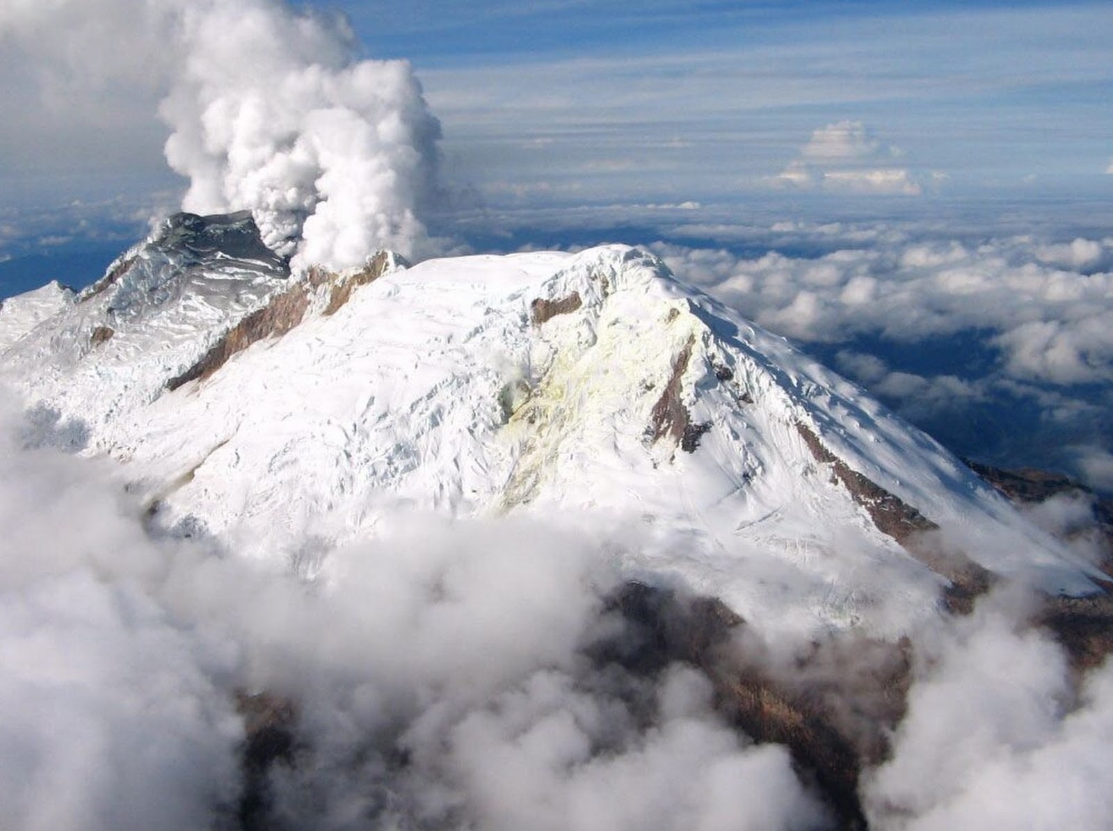
The summit explosive-effusive eruption of the volcano continues. Against the background of explosive activity of the Strombolian type (lava fountaining in the volcanic crater), the lava flows continue to effuse along the Apakhonchichsky and Kozyrevsky chutes on the southern slope of the volcano. Satellite data by KVERT showed an ash plume extending about 150 km to the east of the volcano.
The summit explosive-effusive eruption of the volcano continues. Ash explosions up to 7-8 km (23,000-26,240 ft) a.s.l. could occur at any time. Ongoing activity could affect international and low-flying aircraft.
Volcanic cloud height:
5500-6000 m (18040-19680 ft) AMSL Time and method of ash plume/cloud height determination: 20231025/0430Z – Video data
Other volcanic cloud information:
Distance of ash plume/cloud of the volcano: 150 km (93 mi)
Direction of drift of ash plume/cloud of the volcano: E / azimuth 86 deg
Time and method of ash plume/cloud determination: 20231025/0400Z – Himawari-9 14m15
Source : Kvert
Photo : Yu. Demyanchuk. IVS FEB RAS, KVERT