October 24 , 2023.
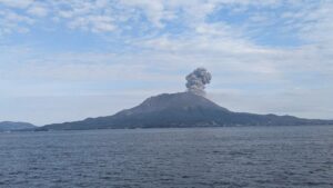
Hawaii , Kilauea :
Monday, October 23, 2023, 8:42 AM HST (Monday, October 23, 2023, 18:42 UTC)
19°25’16 » N 155°17’13 » W,
Summit Elevation 4091 ft (1247 m)
Current Volcano Alert Level: ADVISORY
Current Aviation Color Code: YELLOW
Activity Summary:
Kīlauea volcano is not erupting. The unrest to the south-southwest of Kīlauea’s summit has continued over the past 24 hours in association with an intrusive event that began in early October. Unrest may continue to wax and wane with changes to the input of magma into the area. The summit of Kīlauea remains at a high level of inflation and eruptive activity is possible in the coming weeks or months. No unusual activity has been noted along Kīlauea’s East Rift Zone or the Southwest Rift Zone.
Summit Observations:
Unrest to the south and southwest of the summit area of Kīlauea remained elevated over the past day. Waxing and waning of unrest may continue.
Renewed seismicity beneath the south end of Kīlauea caldera extending to the southwest along the trend of December 1974 vents began a week ago on October 16. The renewed activity initially peaked on October 17, but following a decline of several days, the seismic unrest over the past three days has again been at levels similar to or somewhat higher that on the 17th. Over the past 24 hours, approximately 174 earthquakes were recorded in Kīlauea’s summit region, an increase from 109 during the previous day. Most of the earthquakes related to this unrest are at depths of around 1–3 km (0.6–2 mi) below the surface.
The Uēkahuna summit tiltmeter located north of the caldera was generally flat over the past day. The Sand Hill tiltmeter, located just southwest of the caldera, showed ongoing inflation over the past 24 hours. Overall, inflation at the summit of Kīlauea remains high and has surpassed the level seen just before the most recent eruption on September 10th. However, the current rate of inflation in the region has diminished significantly since October 4-6.
Sulfur dioxide (SO2) emission rates remain low and were measured at a rate of about 100 tonnes per day on October 19.
It is unclear if unrest in Kīlauea summit region will continue and it is not possible to say with certainty if activity will lead to an eruption; activity may remain below the ground surface. However, an eruption remains possible, most likely in Kīlauea’s summit region inside of Hawai‘i Volcanoes National Park and away from infrastructure. Similar patterns of earthquake activity and ground deformation occurred to the south of the caldera prior to the September and June 2023 eruptions in Kīlauea summit caldera (in Halemaʻumaʻu crater and on the downdropped block). Volcanic gas emissions pose the greatest hazard to areas downwind of Kīlauea’s summit.
There is currently no sign of an imminent eruption and increasing inflation and earthquake activity (heightened unrest) are expected to precede an eruption. During periods of heightened unrest prior to recent eruptions at Kīlauea summit, signs of imminent eruption did not appear until 1-2 hours before lava reached the surface. The summit of Kīlauea remains at a high level of inflation and eruptive activity is possible in the coming weeks or months. HVO scientists will continue to monitor Kīlauea volcano closely and will issue additional messages as warranted by changing activity.
Source : HVO
Photo : USGS/ K. Mulliken ( archive)
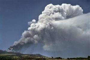
Kamchatka , Klyuchevskoy :
VOLCANO OBSERVATORY NOTICE FOR AVIATION (VONA)
Issued: October 23 , 2023.
Volcano: Klyuchevskoy (CAVW #300260)
Current aviation colour code: ORANGE
Previous aviation colour code: orange
Source: KVERT
Notice Number: 2023-124
Volcano Location: N 56 deg 3 min E 160 deg 38 min
Area: Kamchatka, Russia
Summit Elevation: 4750 m (15580 ft)
Volcanic Activity Summary:
The summit explosive-effusive eruption of the volcano continues. Against the background of explosive activity of the Strombolian type (lava fountaining in the volcanic crater), the lava flow continue to effuse along the Kozyrevsky chute on the southwestern slope of the volcano. Satellite data by KVERT showed an ash plume extending about 75 km to the north-east of the volcano.
The summit explosive-effusive eruption of the volcano continues. Ash explosions up to 7-8 km (23,000-26,240 ft) a.s.l. could occur at any time. Ongoing activity could affect international and low-flying aircraft.
Volcanic cloud height:
5500-6000 m (18040-19680 ft) AMSL Time and method of ash plume/cloud height determination: 20231023/2030Z – Video data
Other volcanic cloud information:
Distance of ash plume/cloud of the volcano: 75 km (47 mi)
Direction of drift of ash plume/cloud of the volcano: NE / azimuth 42 deg
Time and method of ash plume/cloud determination: 20231023/2010Z – Himawari-9 14m15
Source : Kvert
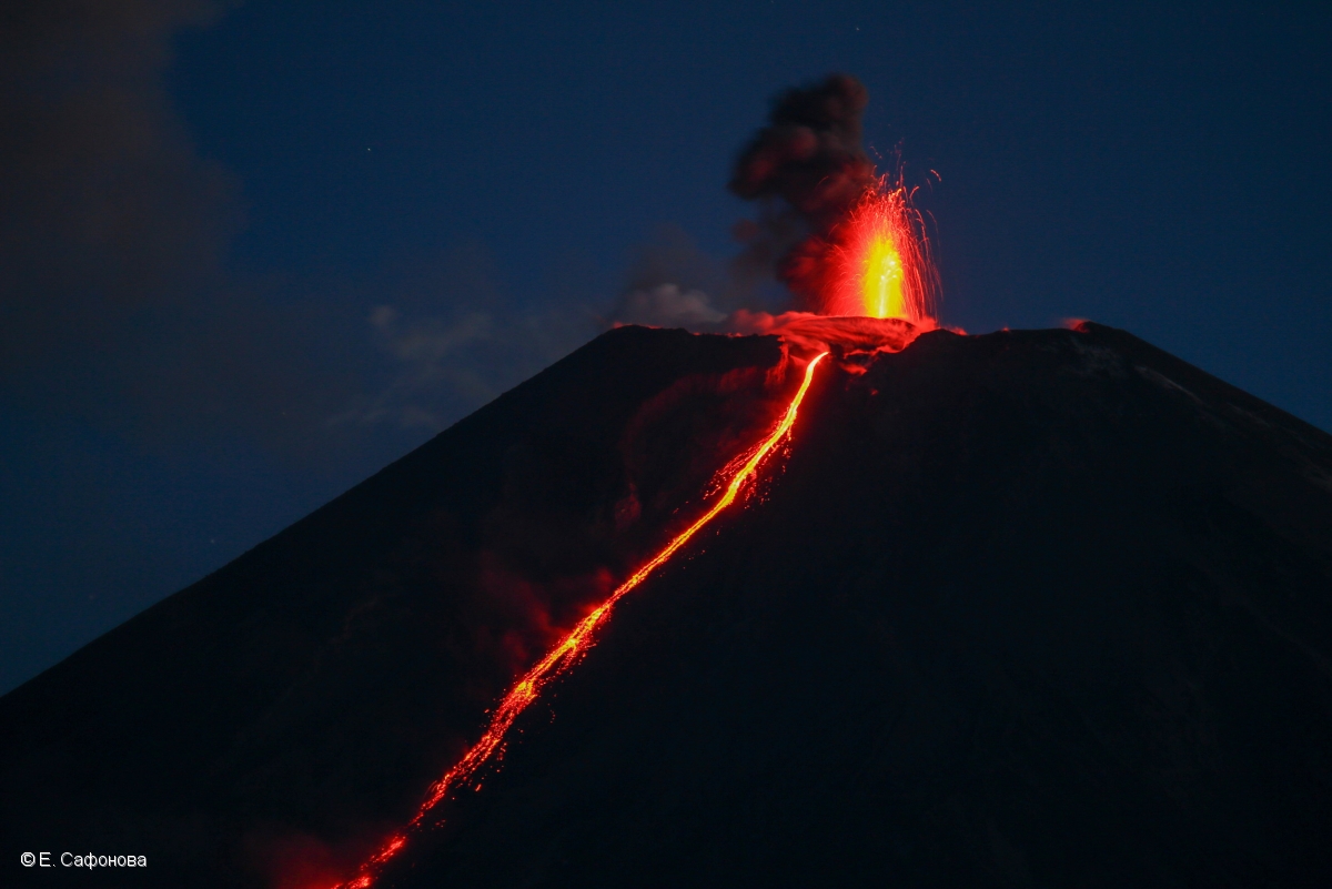
Photo : E. Saphonova (10/6/2020)
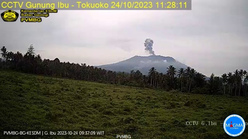
Indonesia , Ibu :
Mount Ibu exhibited an eruption on Tuesday, October 24, 2023 at 11:26 a.m. WIT with the height of the ash column observed at ±800 m above the summit (±2,125 m above sea level). The ash column was observed to be gray with thick intensity, oriented towards the Northeast. This eruption was recorded on a seismograph with a maximum amplitude of 28 mm and a duration of 60 seconds
VOLCANO OBSERVATORY NOTICE FOR AVIATION – VONA
Issued : October 24 , 2023
Volcano : Ibu (268030)
Current Aviation Colour Code : ORANGE
Previous Aviation Colour Code : orange
Source : Ibu Volcano Observatory
Volcano Location : N 01 deg 29 min 17 sec E 127 deg 37 min 48 sec
Area : North Maluku, Indonesia
Summit Elevation : 4240 FT (1325 M)
Volcanic Activity Summary :
Eruption with volcanic ash cloud at 02h26 UTC (11h26 local).
Volcanic Cloud Height :
Best estimate of ash-cloud top is around 6800 FT (2125 M) above sea level or 2560 FT (800 M) above summit. May be higher than what can be observed clearly. Source of height data: ground observer.
Other Volcanic Cloud Information :
Ash cloud moving to northeast. Volcanic ash is observed to be gray. The intensity of volcanic ash is observed to be thick.
Remarks :
Eruption recorded on seismogram with maximum amplitude 28 mm and maximum duration 60 second.
Source : Magma Indonesia
Iceland , Reykjanes Peninsula :
Weekly overview, 16. – 22. October – week 42.
Nearly 500 earthquakes were detected last week by the IMO’s SIL system. This is rather quiet compared to the past three weeks which all have counted over 700 earthquakes. Seismic activity was rather distributed over the countries most active areas, although the activity on Reykjanes peninsula was most noticable, whilst activity in Grímvötn and Bárðarbunga were also noticable, as it has been for the past weeks.
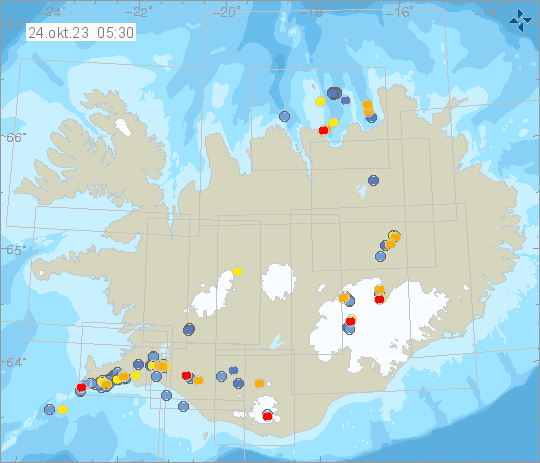
No earthquake measured at a magnitude above M3.0 this week and the largest event was a M2,6 on Reykjanes ridge.
Other interesting activity this was an earthquake M1.7 in Esjufjöll and two minor earthquakes on on the Selvogur continental shelf.
Source et photo : IMO.
Peru , Sabancaya :
Analysis period: from October 16, 2023 to October 22, 2023, Arequipa, October 23, 2023.
Alert level: ORANGE
The Geophysical Institute of Peru (IGP) reports that the eruptive activity of the Sabancaya volcano remains at moderate levels, that is, with the recording of an average of 6 daily explosions, with columns of ash and of gas up to 2 km altitude above the summit of the volcano and their subsequent dispersion. Therefore, for the following days, no significant changes are expected regarding eruptive activity.
The IGP recorded and analyzed the occurrence of 105 earthquakes of volcanic origin, associated with the circulation of magmatic fluids inside the Sabancaya volcano. An average of 6 explosions was recorded daily, in addition to recording of Volcano-Tectonic (VT) type events associated with rock fracturing inside the Sabancaya volcano.
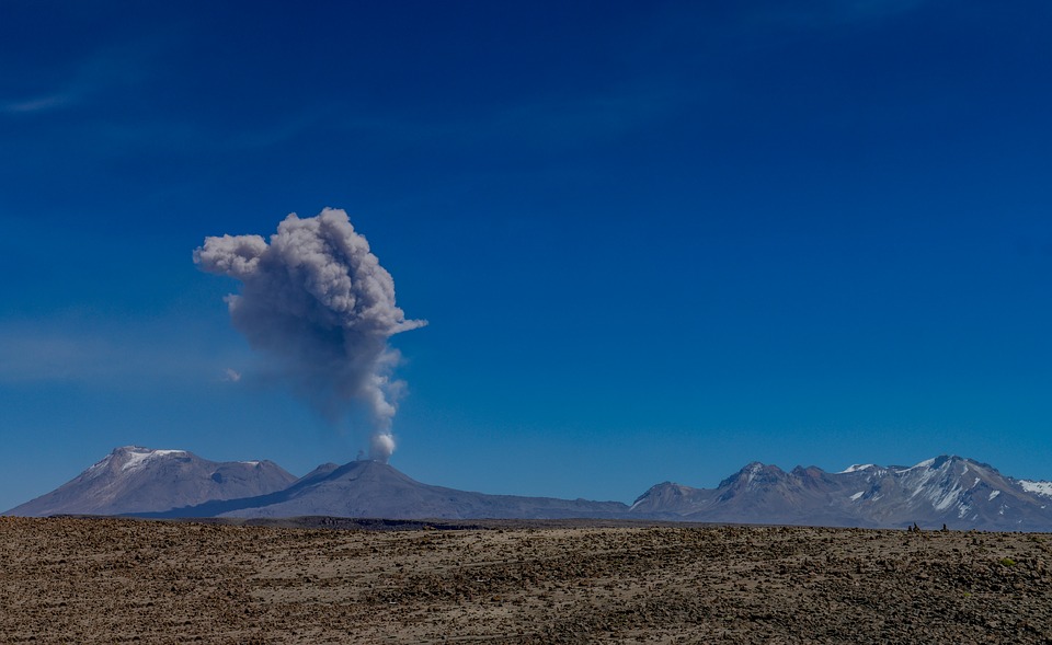
Monitoring the deformation of the volcanic structure using GNSS techniques (processed with fast orbits) does not present significant anomalies. However, in general, a slight inflation process was observed in the northern sector (around the Hualca Hualca volcano). Visual monitoring made it possible to identify columns of gas and ash up to 2 km above the summit of the volcano, which were dispersed towards the South and South-East sectors of Sabancaya. Satellite recordings identified the presence of 2 thermal anomalies, with a maximum value of 12 MW, associated with the presence of a lava body on the surface of the volcano crater.
RECOMMENDATIONS
• Keep the volcano alert level in orange.
• Do not approach within a radius of less than 12 km from the crater.
Source : Cenvul.
Photo : pixabay