October 11, 2023.
Italy , Stromboli :
BULLETIN HEBDOMADAIRE, du 02 Octobre 2023 au 08 Octobre 2023. (date d’émission 10 Octobre 2023)
SUMMARY STATEMENT OF ACTIVITY
In light of the monitoring data, it appears:
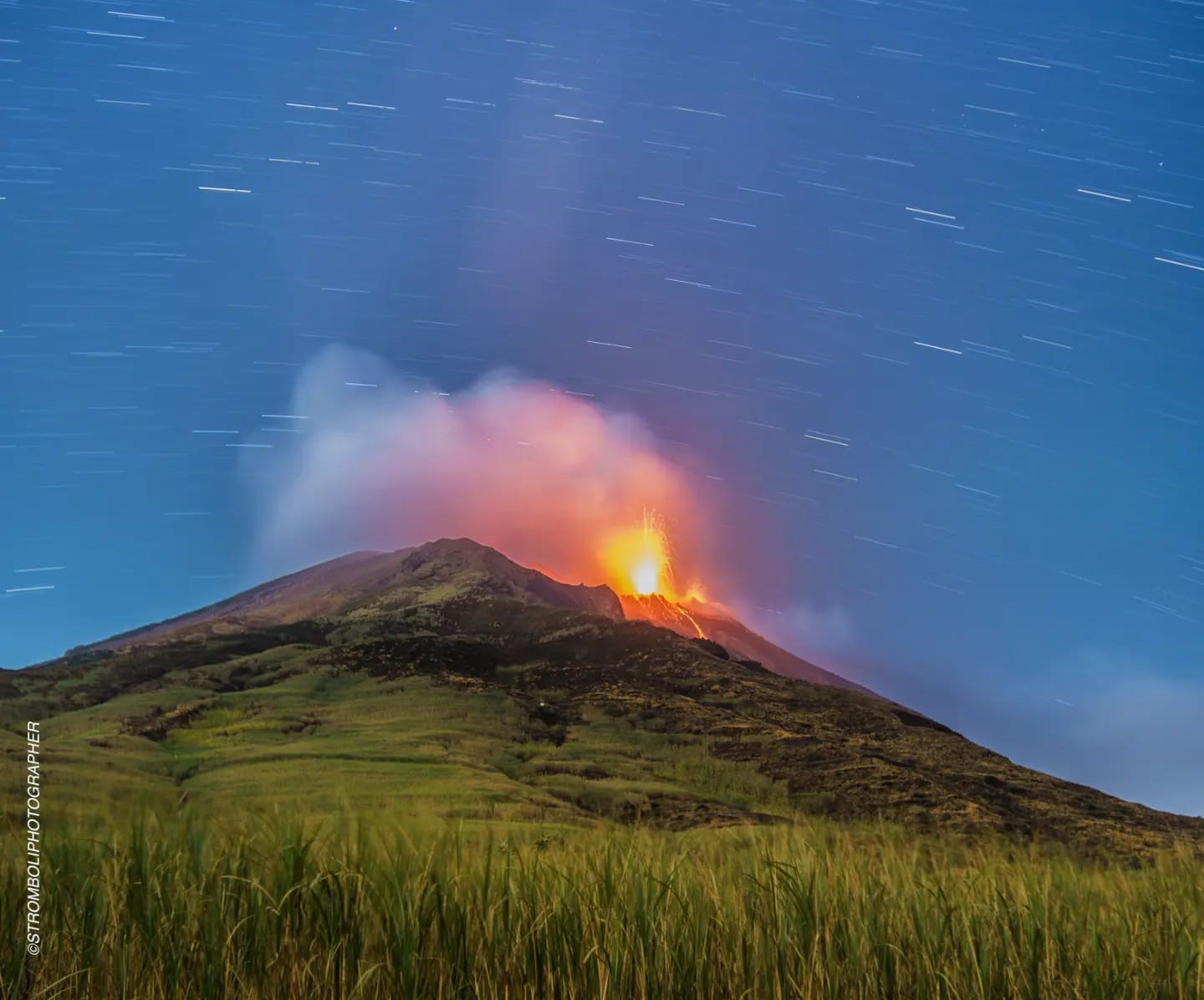
1) VOLCANOLOGICAL OBSERVATIONS: During this period, normal Strombolian activity was observed with splashing activity in the North and CS crater areas. Additionally, four lava overflows were produced from the N crater area, all located in the Sciara del Fuoco. The total hourly frequency of explosions varied between medium values (14 events/h) and high values (20 events/h). The intensity of the explosions varied from low to medium in the N crater area and high in the South-Central area.
2) SISMOLOGY: The monitored seismological parameters do not show significant variations.
3) GROUND DEFORMATIONS: The island’s ground deformation monitoring networks did not show significant variations during the period studied.
4) GEOCHEMISTRY: SO2 flux at an average level and increasing since August
The CO2 flow in the Pizzo area presents average values.
There are no updates for the C/S ratio.
The isotopic ratio of Helium dissolved in thermal wells shows a further increase, reaching high values.
5) SATELLITE OBSERVATIONS: Thermal activity observed by satellite has generally been at a moderate to high level.
VOLCANOLOGICAL OBSERVATIONS
In the observed period, the eruptive activity of Stromboli was characterized through the analysis of images recorded by the INGV-OE surveillance cameras of Pizzo sopra la Fossa (SPT) and Punta dei Corvi (SCV). Furthermore, as part of the activities envisaged in the UNO and DYNAMO projects, observations of volcanic activity and the morpho-structural structure of the crater terrace were carried out and drone overflights were carried out on 7, 8 and October 9.
The explosive activity was mainly produced by 4 eruptive vents located in the North crater area and by 3 vents located in the South Central area.
Four lava overflows were produced in the northern area of the crater.
Observations of explosive activity captured by surveillance cameras
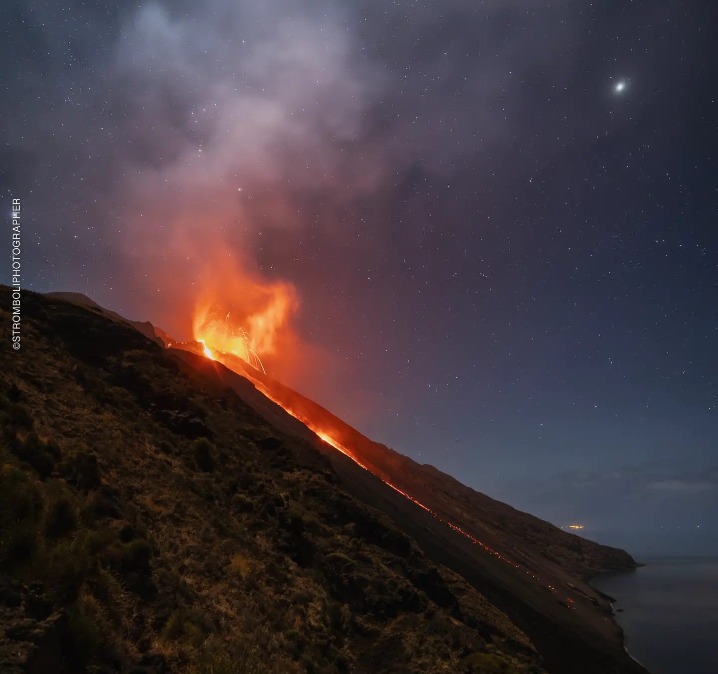
In the area of the North crater (N), characterized by three vents located in sector N1 and one in sector N2, explosive activity of varying intensity from low (less than 80 m high) to medium (less than 150 m high) has been observed and sometimes of great height (more than 150 m in height). The products emitted in the eruption were mainly coarse materials (bombs and lapilli) sometimes mixed with fine materials (ashes). Additionally, continuous spattering activity was observed in sector N1, intense for most of the period, and in conjunction with lava overflows. The average frequency of explosions fluctuated between 6 and 11 events/h.
In the South-Central (CS) zone, sectors S1 and C did not show significant activity while sector S2, characterized by three active vents even at the same time, mainly showed a high intensity explosion (more 150 m high) emitting coarse materials widely distributed along the outer slopes of the crater terrace. Additionally, splashes were observed from October 4 to 7 and 8. The average frequency of explosions oscillated between 7 and 9 events/h
Lava overflows on October 3-6-7-8, 2023.
On October 3-9-7 and 8, four lava overflows were emitted from sector N1 of the N crater area.
Below is the description of effusive events. Times are in UTC.
October 3
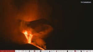
From 06:27 a.m. after intense projection activity in sector N1, an overflow of lava began from the area of the crater N which, after an initial rolling of lava blocks (Fig. 3.3 a) inside the part The upper part of the Sciara du Feu took on the characteristics of a lava flow after a short period (Fig. 3.3 b). The lava flow was well fed, channeling into the canyon present in the Sciara and around 2:00 p.m., it seemed poorly fed and cooled (Fig. 3.3 c).
October 6
From 00:45, after intense splashing activity in sector N1, lava overflow began from the crater area N (Fig. 3.3 d and e). The well-fed lava flow channeled into the canyon present in the Sciara and around 7:30 a.m., it appeared poorly fed and cooled (Fig. 3.3 f). This lava flow was the only one to reach the coastline with a small accumulation deposit, barely visible on the SPCT infrared camera.
October 7
From 03:00, after intense splashing activity in the N1 sector, a lava overflow began from the N crater area (Fig. 3.3 g and h) in the upper part of the Sciara del Fuoco. This well-fed flow was channeled into the Canyon present in the Sciara del Fuoco and around 08:00 it appeared poorly fed and cooled.
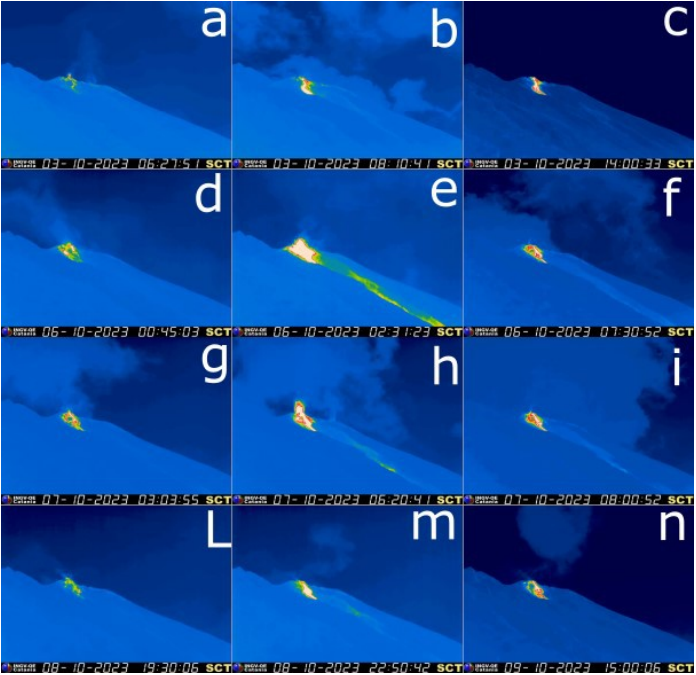
October 8
From 7:30 p.m., after intense splashing activity in the N1 sector, a lava overflow began from the N crater area in the upper part of the Sciara del Fuoco (Fig. 3.3 l and m). The well-fed lava flow channeled into the canyon present in the Sciara and was subject to notable fluctuations in emission rate until it appeared poorly fed and cooled around 3:00 p.m. on October 9.
Ground and drone observations on October 7, 8 and 9
As part of the activities envisaged in the UNO and DYNAMO projects, observations of volcanic activity and the morpho-structural structure of the crater terrace and drone overflights were carried out. The products of the drone surveys are the digital surface model (DSM) and the orthomosaic and thermal orthomosaic with a resolution of 25 cm (Figure 3.5 a, b, c respectively).
Observation of eruptive activity made it possible to identify active chimneys and characterize their eruptive style (blue circles in Figure 3.5b).
On October 7, 5 vents were active, two in sector N1 of the crater terrace, one in sector N2 and two in sector S2, while on October 8 and 9, 4 vents with only one vent were active in the Central sector-South zone.
In the northern zone, the N1 crater was characterized by the presence of two active and incandescent vents with explosions and emission of coarse matter without ash and episodes of projections due to the level of magma close to the surface.
The N2 crater area was instead characterized by a single active, incandescent vent which, during the observation period, produced vertical explosions of gas, with little, mostly coarse, material and a modest amount of gas and ash. .
In the South-Central zone, there were two vents in sector S2, the easternmost of which, incandescent, produced explosions and emissions of coarse matter without ashes while the westernmost one was characterized by explosions of fresh and reworked ash mixed with coarse material on October 7 (figure 3.5 d). On October 8 and 9, there was only one vent located at the bottom of the crater characterized by explosions of coarse material and ash.
Press release on Stromboli activity, October 10, 2023, 10:35 a.m. (08:35 UTC).
The National Institute of Geophysics and Volcanology, Osservatorio Etneo, communicates that during the night, there was a gradual decrease in the intensity of the projections which fueled the lava overflow reported in the press release of October 8 (8:08 p.m. UTC ). Analysis of surveillance camera images shows that the lava overflow is currently unfed and cooling. In the northern area of the crater, in addition to the splashes, Strombolian activity persists. In addition, Strombolian activity is observed from the Center-South crater area.
From a seismic point of view, the average amplitude of the volcanic tremor is currently at high values. No significant changes were reported in the frequency of occurrence and amplitude of explosion earthquakes.
The deformation data from the inclinometer and GNSS networks do not show significant variations.
Further updates will be communicated shortly.
Source : INGV.
Photos : Stromboli stati d’animo / sebastiano Cannavo. INGV
Colombia , Chiles / Cerro Negro :
Weekly activity bulletin of the Chiles and Cerro Negro Volcanic Complex (CVCCN)
Regarding the monitoring of the activity of the CHILES AND CERRO NEGRO VOLCANOES, the MINISTRY OF MINES AND ENERGY, through the COLOMBIAN GEOLOGICAL SERVICE (SGC), reports that:
In the week of October 3 to 9, 2023, the appearance of a seismic swarm is highlighted which began on October 5, 2023 at 3:55 p.m., generated from the recording of an ML 4.1 earthquake, which It was located 2.3 km south of the Chiles volcano and 3.3 km deep (reference level above 4,700 m above sea level), and was reported as felt by the inhabitants of the indigenous reserve of Chiles. This earthquake triggered a stress release that manifested itself in increased frequency and energy, primarily rock fracturing earthquakes. Over the course of the week, this swarm of earthquakes gradually diminished.
The fracture earthquakes were located at distances up to 5 km south of the Chiles volcano and at depths between 2 and 8 km (reference level above 4,700 m above sea level). Deformation in several sectors of the volcanic edifice was maintained, detected instrumentally by sensors installed in the volcanoes as well as by satellite sensors.
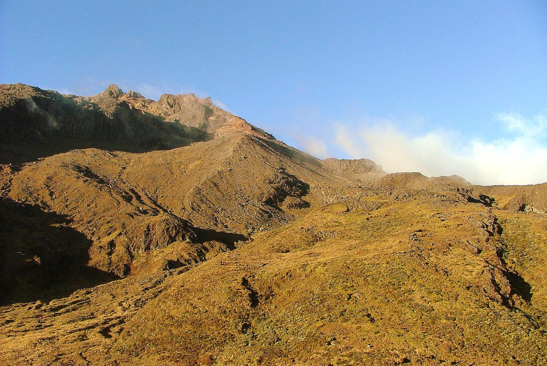
The evolution of activity in the CVCCN continues based on the different manifestations recorded, which respond to processes derived from a complex interaction between the magmatic, hydrothermal system and the geological faults of the area, which can trigger the occurrence of energetic earthquakes that are felt by residents in the area of influence of the CVCCN, as well as generating instability on slopes, landslides and structural damage to buildings, access roads, bridges, etc. These are aspects that must continue to be taken into account by the authorities and the communities that reside in the zone of influence of these volcanoes.
The state of alert for volcanic activity remains at:
YELLOW ALERT: Active volcano with changes in the behavior of the base level of monitored parameters and other manifestations
Source : Ingeominas
Photo : Boriss Andean summit post
Alaska , Shishaldin :
54°45’19 » N 163°58’16 » W,
Summit Elevation 9373 ft (2857 m)
Current Volcano Alert Level: WATCH
Current Aviation Color Code: ORANGE
Volcanic unrest remains elevated at Shishaldin Volcano, with sulfur dioxide gas emissions and frequent small earthquakes detected over the past day. Elevated surface temperatures were evident in partly clear satellite views, but no significant explosions or ash clouds have occurred over the past day. Several clear web camera views showed minor vapor emissions at the summit.
Twelve significant explosive events have occurred at Shishaldin since July 12, 2023. These events have been preceded by increases in seismicity in the hours to days before they occur. It is unknown how long this period of ongoing activity will last. However, previous eruptions of Shishaldin Volcano have lasted weeks to months with repeated cycles of eruptive activity like those seen since July.
Local seismic and infrasound sensors, web cameras, and a geodetic network monitor Shishaldin Volcano. In addition to the local monitoring network, AVO uses nearby geophysical networks, regional infrasound and lighting data, and satellite images to detect eruptions.
Source : AVO
Photo : Matt Brekke
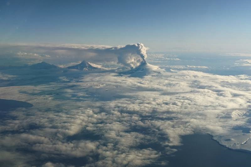
Kamchatka , Klyuchevskoy :
VOLCANO OBSERVATORY NOTICE FOR AVIATION (VONA)
Issued: October 11 , 2023 .
Volcano: Klyuchevskoy (CAVW #300260)
Current aviation colour code: ORANGE
Previous aviation colour code: yellow
Source: KVERT
Notice Number: 2023-105
Volcano Location: N 56 deg 3 min E 160 deg 38 min
Area: Kamchatka, Russia
Summit Elevation: 4750 m (15580 ft)
Volcanic Activity Summary:
An activity of the volcano increased from 11 October: some amount of ash appeared in gas-steam plumes. The summit explosive-effusive eruption of the volcano continues. Against the background of explosive activity of the Strombolian type (lava fountaining in the volcanic crater), the lava flows continue to effuse alternately along the Kozyrevsky and Apakhonchichsky chutes on the southern slopes of the volcano. Satellite data by KVERT showed a gas-steam plume containing some amount of ash is extending for 65 km to the northeast of the volcano.
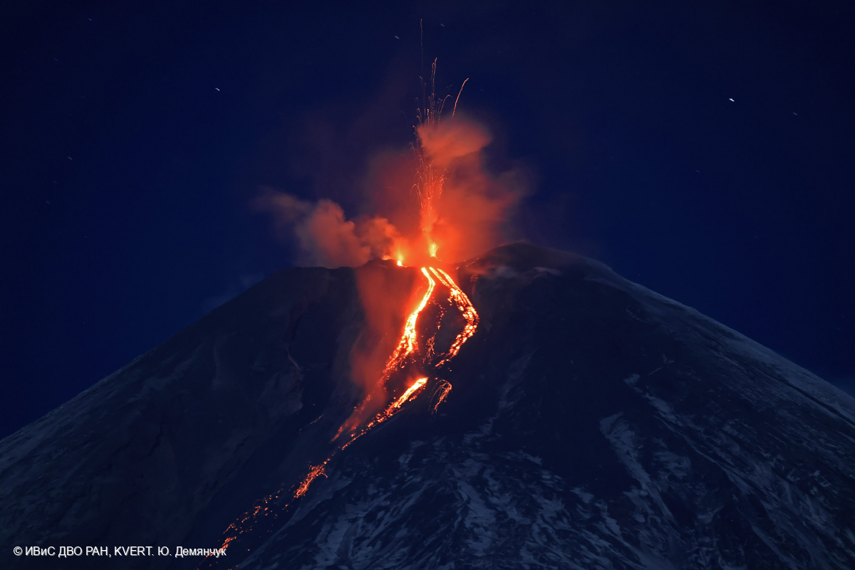
The summit explosive-effusive eruption of the volcano continues. Ash explosions up to 7-8 km (23,000-26,240 ft) a.s.l. could occur at any time. Ongoing activity could affect international and low-flying aircraft.
Volcanic cloud height:
5500-6000 m (18040-19680 ft) AMSL Time and method of ash plume/cloud height determination: 20231011/0150Z – Himawari-9 14m15
Other volcanic cloud information:
Distance of ash plume/cloud of the volcano: 65 km (40 mi)
Direction of drift of ash plume/cloud of the volcano: NE / azimuth 41 deg
Time and method of ash plume/cloud determination: 20231011/0150Z – Himawari-9 14m15
Source : Kvert
Photo : Yu. Demyanchuk. IVS FEB RAS, KVERT
Hawaii , Kilauea :
Tuesday, October 10, 2023, 12:09 PM HST (Tuesday, October 10, 2023, 22:09 UTC)
19°25’16 » N 155°17’13 » W,
Summit Elevation 4091 ft (1247 m)
Current Volcano Alert Level: ADVISORY
Current Aviation Color Code: YELLOW
Activity Summary:
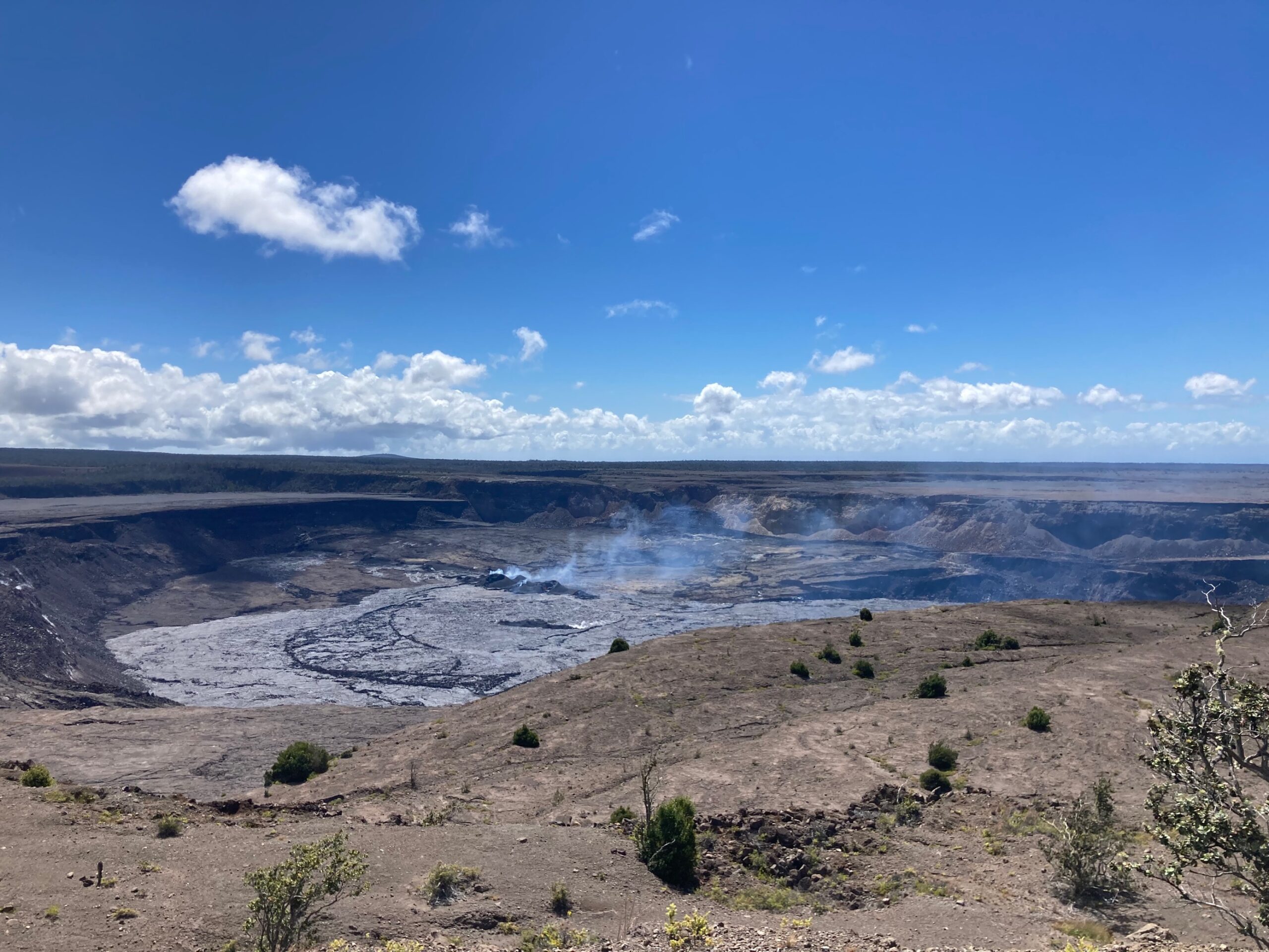
Kīlauea volcano is not erupting. The area just south of Kīlauea’s summit is showing signs of episodic heightened unrest. No unusual activity has been noted along Kīlauea’s East Rift Zone or Southwest Rift Zone
Summit Observations:
Episodic heightened unrest continues in the south summit area of Kīlauea and an eruption in the region from Halemaʻumaʻu south to the December 1974 vents could emerge with little notice (1-2 hours) during peaks in this activity. Inflation at the summit of Kīlauea remains at about its highest level in over 5 years and has nearly returned to the level seen just before the last eruption on September 10th. The Uēkahuna summit tiltmeter located north of the caldera recorded very slight inflation over the past 24 hours. The Sand Hill tiltmeter located just south of the caldera went off scale during the peak activity on October 6th, but has been reset and is showing continued inflation but at a lower rate than before the event. GPS units within the south end of the caldera and further south also show continued uplift of this region. Elevated seismicity is being recorded beneath the south end of Kīlauea caldera and extends to the southwest along the trend of December 1974 vents. Seismicity increased on October 4, peaked at over 250 earthquakes per day on October 5 and 6, and continues dispersed over this area. Over the past 24 hours approximately 110 earthquakes were recorded in Kīlauea summit region compared to about 125 earthquakes occurring over the previous day. Most of the earthquakes from the seismic swarm south of the caldera are at depths of around 2.5–3.5 km (1.5–2 mi) below the surface. Sulfur dioxide (SO2) emission rates remain low and were measured at a rate of about 100 tonnes per day on October 6.
Source : HVO
Photo : USGS/ M. Patrick.