August 30 , 2023.
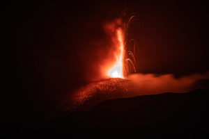
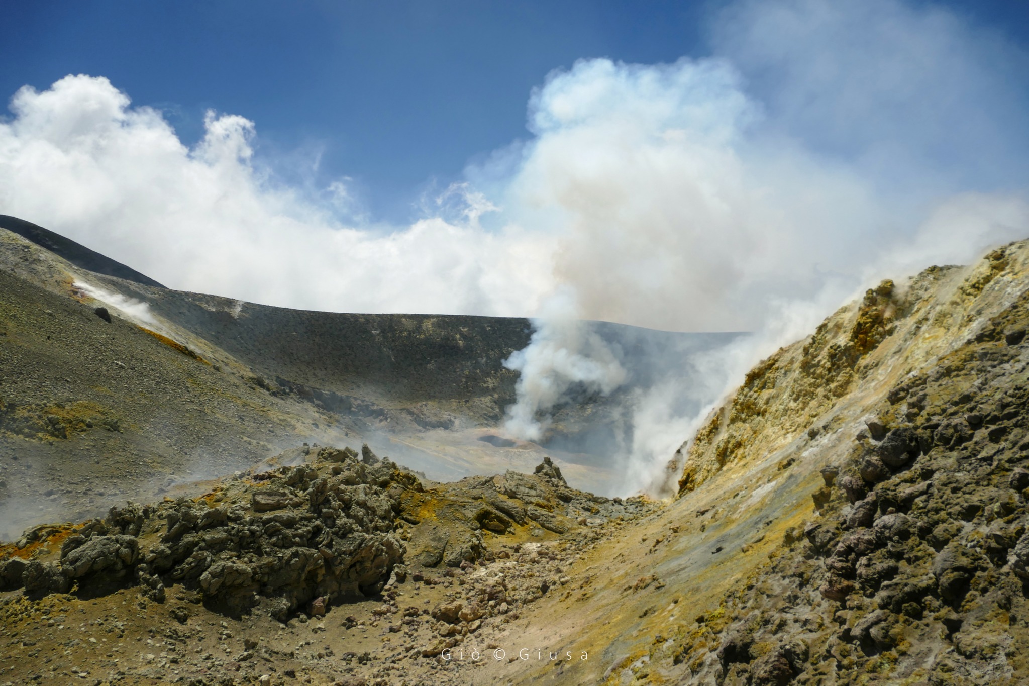
Italy / Sicily , Etna :
WEEKLY BULLETIN, from August 21, 2023 to August 27, 2023. (issue date August 29, 2023)
SUMMARY OF ACTIVITY STATUS
In light of the monitoring data, it appears:
1) VOLCANOLOGICAL OBSERVATIONS: Degassing activity from the summit craters, in particular from the Bocca Nuova and South-East craters; occasional emission of ash from the Southeast crater.
2) SEISMOLOGY: Low seismic activity due to fracturing. The average amplitude of volcanic tremors remained in the range of average values. The source locations were in the Southeast Crater area.
3) INFRASOUND: Increase in the frequency of appearance of infrasound events, which are mainly located in the area of the Bocca Nuova craters and subordinate to the South-East crater.
4) GROUND DEFORMATIONS: There are no significant long-term variations.
5) GEOCHEMISTRY: SO2 flux at a medium-low level
The CO2 flows show no variation, remaining in any case at average values.
There is no update on the helium isotope ratio.
The partial pressure of dissolved CO2 does not show significant variations.
6) SATELLITE OBSERVATIONS: Thermal activity observed by satellite was generally of low level with rare and isolated anomalies of moderate level.
7) OTHER OBSERVATIONS: The magma which fueled the paroxysmal activity has a variable composition, generally comparable to that of the previous paroxysm of the Southeast Crater which occurred in May 2023. However, a slightly more primitive magma intruded into the » magmatic reservoir” (reservoir) which fueled the activity of the Southeast Crater on August 13-14, 2023.
VOLCANOLOGICAL OBSERVATIONS
Monitoring of Etna’s activity was carried out using surveillance cameras from the INGV – Osservatorio Etneo (INGV-OE).
During the observation period, the Southeast Crater was only affected by a small impulsive explosion at 07:00 UTC on August 26, which produced a modest ash cloud, which high-altitude winds quickly dispersed in the air . In the following days, the activity of the summit craters of Etna was characterized by the usual degassing, particularly in the Bocca Nuova crater (BN) and the South-East crater (CSE).
SEISMOLOGY
Fracture seismicity was low and only two earthquakes reached and exceeded the local magnitude threshold of 2.0. In detail, on August 21 at 11:17 p.m. and 11:45 p.m. UTC, two earthquakes of magnitude equal to 2.1 and 2.6 respectively, affected the northeast sector of the volcano, southwest of the city of Motta Camastra and at a depth of approximately 16 km below sea level.
Source : INGV.
Photo : Gio Giusa.
Italy , Stromboli :
WEEKLY BULLETIN, from August 21, 2023 to August 27, 2023. (issue date August 29, 2023)
SUMMARY OF ACTIVITY STATUS
In light of the monitoring data, it appears:
1) VOLCANOLOGICAL OBSERVATIONS: During this period, normal Strombolian activity was observed with spattering activity in the North Crater area. The total hourly frequency fluctuated between medium values (13 events/h) and high values (21 events/h). with an increasing trend. The intensity of the explosions was variable from low to medium in the areas of the North and Center – South craters.
2) SEISMOLOGY: The seismological parameters monitored do not show any significant variations.
3) GROUND DEFORMATIONS: The soil deformation monitoring networks did not show significant variations.
4) GEOCHEMISTRY: SO2 flow at an average level
The CO2 flux in the Pizzo area shows stable values at medium-high levels.
There is no C/S ratio update in the plume.
There is no update on the isotopic ratio of dissolved helium in groundwater.
5) SATELLITE OBSERVATIONS: Thermal activity observed from the satellite was generally weak.
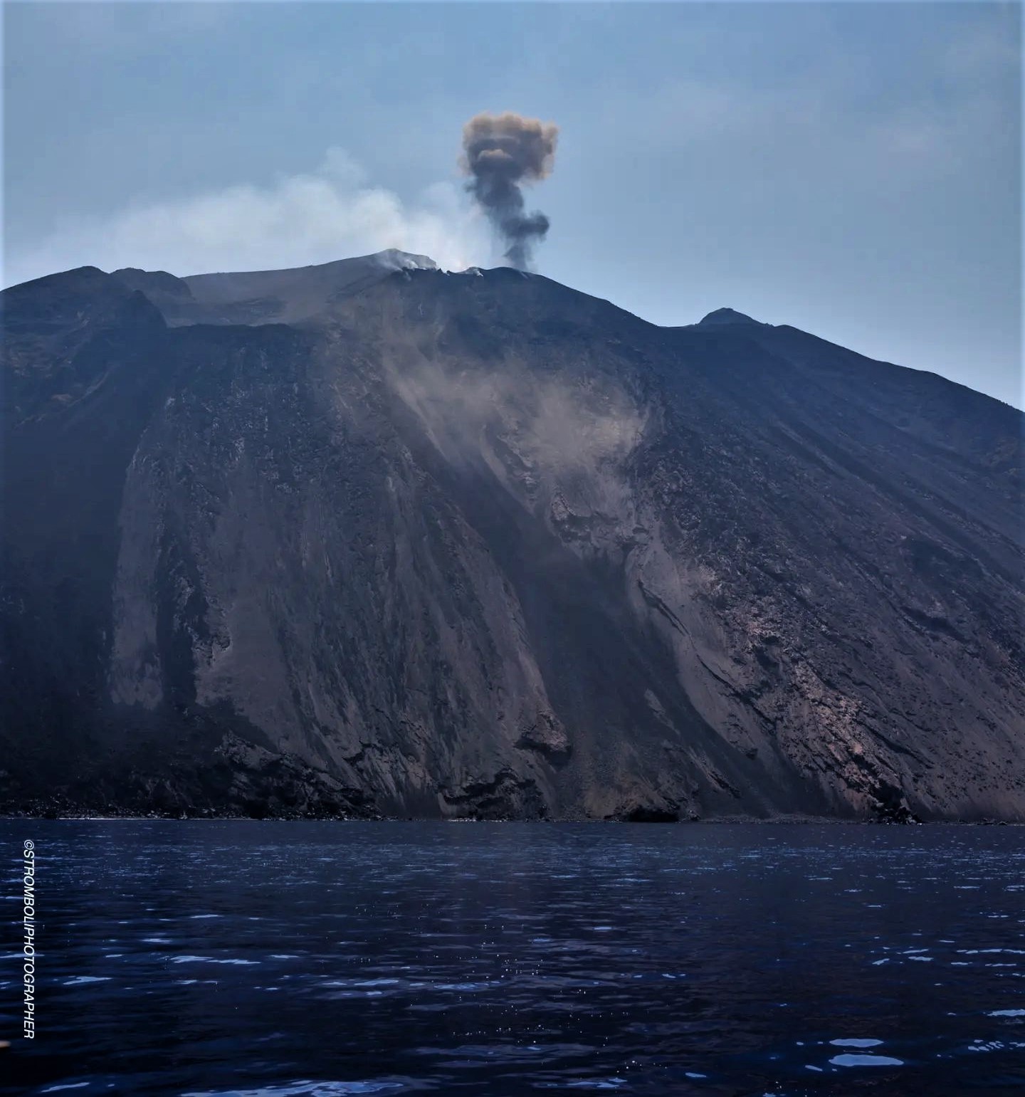
VOLCANOLOGICAL OBSERVATIONS
In the observed period, the eruptive activity of Stromboli was characterized through the analysis of images recorded by the INGV-OE surveillance cameras at an altitude of 190m (SCT-SCV), Pizzo and Punta dei Corvi. The explosive activity was mainly produced by 3 (three) eruptive chimneys located in the northern zone of the crater and by 4 (four) chimneys located in the South-Central zone.
Observations of explosive activity captured by surveillance cameras.
In the area of the North crater (N), with two vents located in sector N1 and one in sector N2, explosive activity of varying intensity from low (less than 80 m in height) to medium (less than 150 m in height). height) was observed. The products of the eruption consisted mainly of coarse materials (bombs and lapilli) sometimes mixed with fine materials (ash). Furthermore, splashing activity was observed in sector N1 which was intense on August 24. The average frequency of explosions varied between 5 and 11 events/h.
In the South-Central (CS) zone, sector S1 did not show significant activity while sector C, sporadically, showed low intensity explosive activity, emitting coarse materials. Sector S2, with three active vents, mainly showed explosive activity of varying intensity from low to medium emitting coarse materials mixed with fine materials. The average frequency of explosions varied between 7 and 11 events/h.
Source : INGV.
Photo : Stromboli Stati d’animo.
Iceland , Skaftá :
Last night the Skaftá discharge and conductivity at Sveinstindur started to increase. IMO has also received reports of sulfuric smell from rangers in the area. It is therefore possible to conclude that a flood of glacier overflows has begun. The last flood occurred in September 2021.
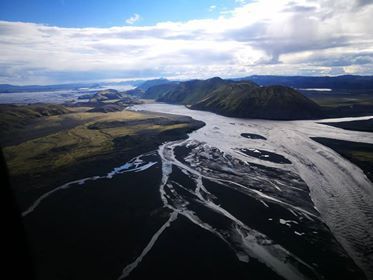
Photo from a surveillance flight on August 4, when the flow had reached its maximum at Sveinstind.
There are two Skaftár cauldrons, the East and the West, and are located in the western part of the Vatnajökull glacier. A flood from the Eastern Cauldron is generally larger than that from the Western Cauldron. It is not confirmed which cauldron produced the flood, but scientists will be looking at satellite data to confirm which cauldron produced the flood or if it was both. This happened in 2021 and could happen again.
The discharge volume at Sveinstindur was 600 m3/s around 9 a.m. and is increasing. It can be expected to reach peak discharge at Þjóðvegur 1 about 10 hours after peak discharge at Sveinstindur is reached. The size of the flood depends on which cauldron produced the flood.
The police and civil protection have declared a state of uncertainty regarding the flooding of the Skaftá.
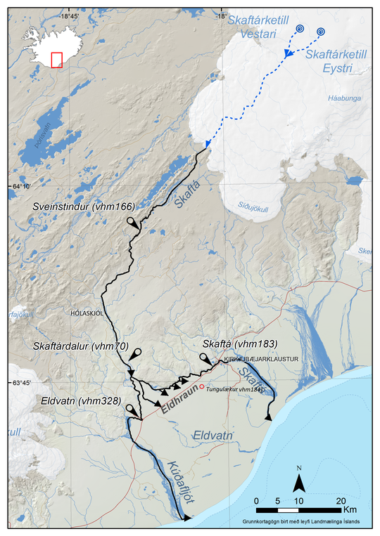
The Skaftá cauldrons, East and West, are located in the western part of the Vatnajökull ice cap. They form because of geothermal activity which melts the glacier from below and water accumulates beneath them. When the hydrostatic pressure is high enough that water lifts the ice above and flows out from under the cauldrons, it causes a flood. Floods from the Eastern Cauldron are generally greater than floods from the Western Cauldron. The Skaftá cauldron floods as we know them today were first observed in 1955 and since then 59 floods have occurred. The average flooding of each cauldron occurs every two years.
Source : IMO.
Photo : Agence météorologique norvégienne/Benedikt G. Ófeigsson.
Colombia , Chiles / Cerro Negro :
Weekly activity bulletin of the Chiles and Cerro Negro Volcanic Complex (CVCCN)
Regarding the monitoring of the activity of the CHILES AND CERRO NEGRO VOLCANOES, the MINISTRY OF MINES AND ENERGY, through the COLOMBIAN GEOLOGICAL SERVICE (SGC), reports that:
For the period between August 22 and 28, 2023, and compared to the immediately preceding weeks, seismic activity continues to decrease both in occurrence values and in energy released. The predominance of earthquakes associated with the fracturing of rocks inside the volcanic edifice continues, followed by seismicity linked to the movement of fluids.
Earthquakes associated with rock fracturing occurred mainly south of Chiles Volcano, at distances up to 4 km, with depths less than 6 km from its summit (4,700 m above sea level) and a maximum magnitude of 2.5. No felt earthquakes were reported.
Deformation processes continue in different sectors of the volcanic edifice, detected instrumentally by sensors installed in the volcanoes as well as by satellite sensors.

The volcanic activity occurring in the zone of influence of the Chiles – Cerro Negro volcanic complex is part of a fluctuating process that has been occurring since late 2013.
the most recent began on March 9, 2023, with the recording of more than 215,000 earthquakes in the last 5 months, most of them related to the fracturing of rocks, which present variations mainly in energy levels and are associated with the complex interaction of the CVCCN magmatic system, the hydrothermal system and the tectonics of the region (geological faults).
The probability of the occurrence of energetic earthquakes that could be felt by residents in the area of influence remains.
In this probable context of activity in the CVCCN, the occurrence of earthquakes of greater magnitude may generate instability on slopes, landslides and structural damage to infrastructure located in the area, such as buildings, roads access, bridges, etc. These aspects must continue to be taken into account by the authorities and communities that reside in the zone of influence of these volcanoes.
The level of activity of volcanoes remains at
YELLOW LEVEL ■ (III): CHANGES IN THE BEHAVIOR OF VOLCANIC ACTIVITY
Source : SGC.
Photo : IGEPN
Hawaii , Kilauea :
Tuesday, August 29, 2023, 9:00 AM HST (Tuesday, August 29, 2023, 19:00 UTC)
19°25’16 » N 155°17’13 » W,
Summit Elevation 4091 ft (1247 m)
Current Volcano Alert Level: ADVISORY
Current Aviation Color Code: YELLOW
Activity Summary:
Kīlauea volcano is not erupting. Kīlauea summit is currently exhibiting signs of elevated unrest. No unusual activity has been noted along Kilauea’s East Rift Zone or Southwest Rift zone.
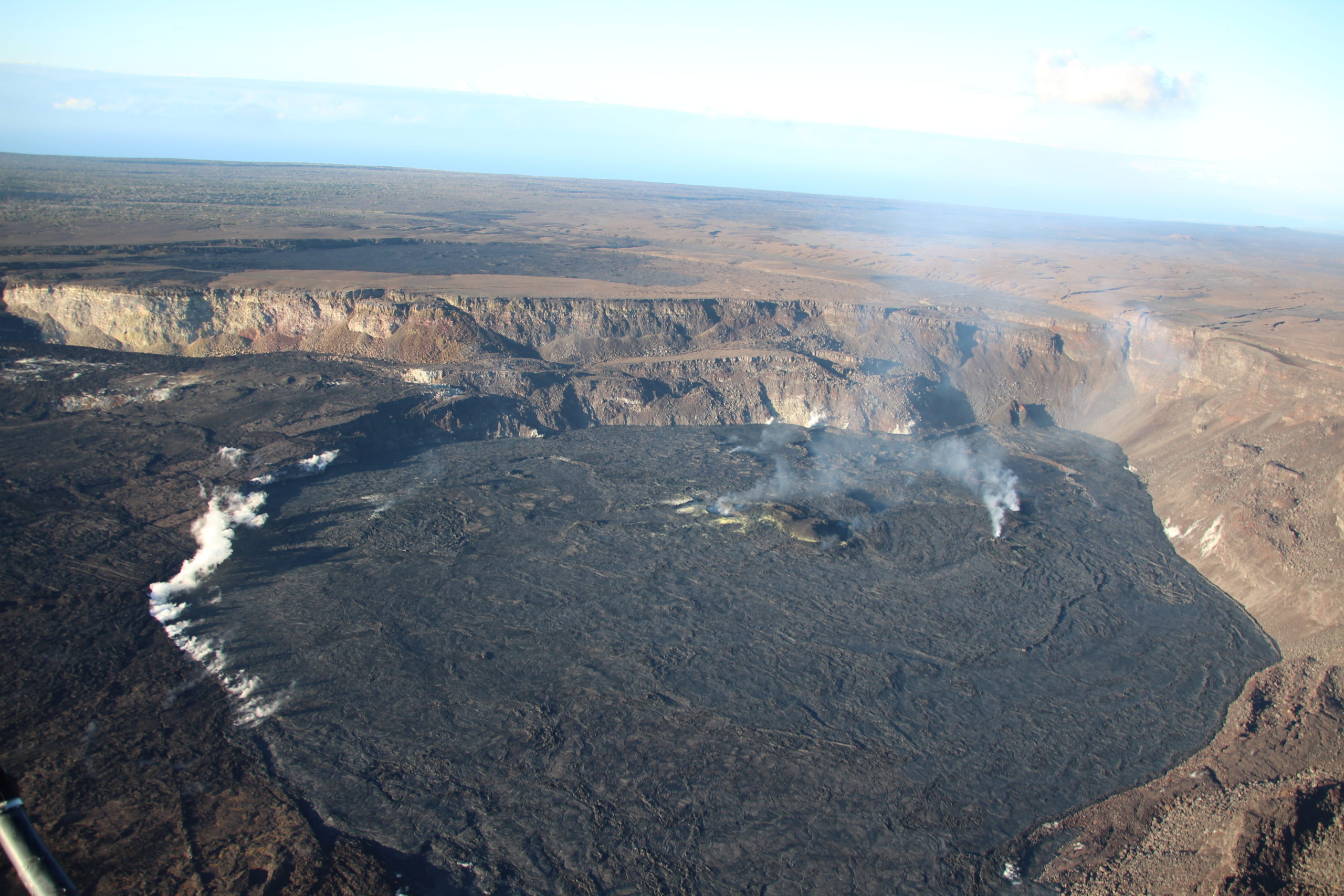
Summit Observations:
Elevated seismic activity continues in an area south of Kīlauea’s summit caldera, though levels were slightly lower yesterday. Earthquakes occurred steadily through the day, without swarm activity. Most earthquakes have been at a depth of 1-2 miles (2-3 km) below the surface, with no upward migration. Summit tiltmeters showed deflationary tilt throughout the day, nonetheless this is expected to be temporary, with rates returning to recent inflationary trends eventually. Sulfur dioxide (SO2) emissions from the summit remain low; the most recent SO2 emission rate, of approximately 75 tonnes per day, was measured on August 24.
The earthquake activity and tiltmeter data indicate that Kīlauea summit is becoming increasingly pressurized. Similar episodes of earthquake and ground deformation activity occurred in November 2020 and August 2021, prior to eruptions in December 2020 and September 2021. The activity is currently confined within Kīlauea’s summit region and if it continues, could escalate to an eruption in the coming days, weeks, or months. The activity could also decrease due to intrusion of magma underground or other changes, resulting in no eruption. Furthermore, levels of activity are expected to rise and fall during this period.
Source : HVO.
Photo : USGS / N. Deligne.