July 27 , 2023.
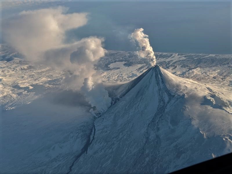
Alaska , Shishaldin :
AVO/USGS Volcanic Activity Notice
Current Volcano Alert Level: WATCH
Current Aviation Color Code: ORANGE
Issued: Wednesday, July 26, 2023, 2:11 AM AKDT
Volcanic Activity Summary:
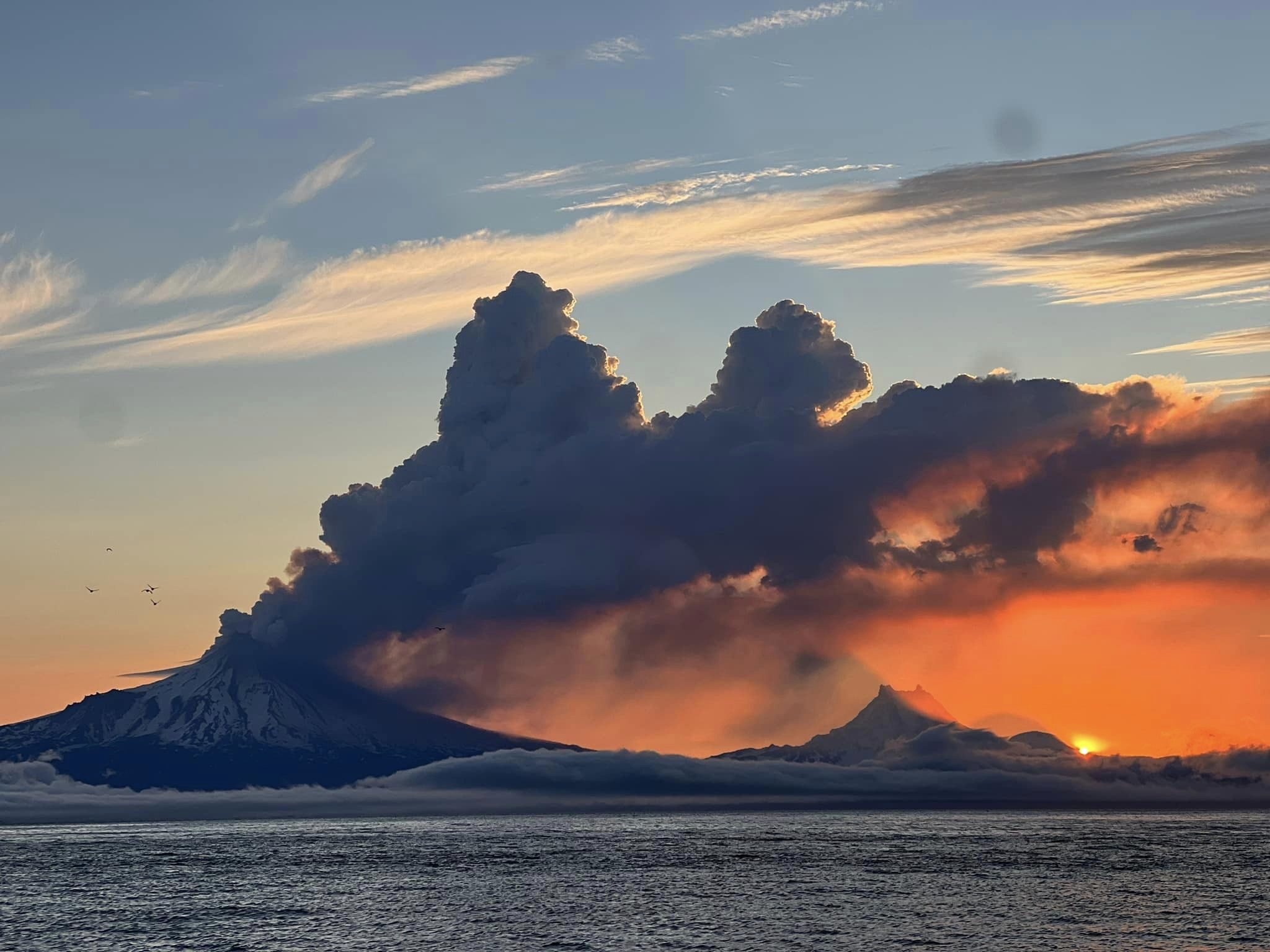
The level of unrest has increased at Shishaldin Volcano. A steady increase in seismic tremor over the past 4 hours and an increase in temperatures at the volcano observed in satellite data over the past 2 hours suggests that explosive activity is imminent. Despite cloud cover obscuring the volcano, elevated surface temperatures consistent with lava erupting at the summit are evident in the latest satellite data. Based on previous eruption cycles, minor ash emissions are likely to occur and may increase over the next few hours.
AVO/USGS Volcanic Activity Notice
Current Volcano Alert Level: WATCH
Current Aviation Color Code: ORANGE
Issued: Wednesday, July 26, 2023, 3:51 AM AKDT
Volcanic Activity Summary:
Explosive eruptive activity is occurring at Shishaldin Volcano. A low-level ash cloud to about 15,000 ft (6 km) above sea level and moving ENE is evident in satellite data. This follows a several-hour increase in seismic tremor and an increase in temperatures at the volcano seen in satellite data. Explosion signals have been detected in infrasound data since at least 02:00 AKDT (10 UTC). The National Weather Service has issued a SIGMET for this ash cloud, and a Marine Weather Statement has been issued for possible trace ash on marine waters NE of the volcano.
Based on previous eruption cycles, significant ash emissions are likely to continue for the next few hours. Pyroclastic and mudflows are likely on the immediate flanks of the volcano.
Shishaldin Volcano is monitored by local seismic and infrasound sensors, web cameras, and a telemetered geodetic network. The local monitoring network has been partially impaired over the last few weeks due to telecommunications issues but seismic stations and web cameras south of the volcano were brought back online on July 19. In addition to the local monitoring network, AVO uses nearby geophysical networks, regional infrasound and lighting data, and satellite images to detect eruptions.
Recent Observations:
[Volcanic cloud height] 15,000 ft (4.6 km) above sea level
[Other volcanic cloud information] Unknown
Hazard Analysis:
[Ash cloud] 15,000 ft (4.6 km) above sea level
[Ashfall] Trace ashfall NE of the volcano
[Pyroclastic flow] likely on the immediate flanks of the volcano
[Mud flow] likely on the immediate flanks of the volcano
Issued: Wednesday, July 26, 2023, 1:27 PM AKDT
The eruption of Shishaldin Volcano has gradually declined after increasing overnight. Seismicity has decreased and significant explosions are no longer being detected in infrasound data. Meteorological clouds up to 20,000–25,000 ft (6.1–7.6 km) above sea level began obscuring views of the volcano starting around 11:30 am AKDT (17:30 UTC). It is likely that lingering low-level ash emissions are continuing in the vicinity of the volcano.
Source : AVO
Photos : Brekke, Matt , Nick Enloe . ( archives).
La Réunion , Piton de la Fournaise :
Press release from the Institut de physique du globe de Paris, Volcanological Observatory of Piton de la Fournaise, July 26, 2023 – 11h00 – 07h00 UTC
Ongoing eruption
The eruption which began on July 02, 2023, around 08:30 local time continues. The amplitude of the volcanic tremor (indicator of an emission of lava and gas on the surface) remains very low compared to the start of the eruption and still shows a slight downward trend.
Thanks to the good weather conditions on the volcano in the past 24 hours, lava flow estimates have been calculated by satellite method on the HOTVOLC platform (OPGC – Clermont Auvergne University) and MIROVA (University of Turin). During the last 24 hours the flows were between <1 and 3.1 m3/sec. Given the cloud mass present regularly on the eruptive site as well as the presence of lava tunnels, these flows may be underestimated.
Since the start of the eruption, the total volume of lava emitted on the surface is around 9.6 (± 3.4) Mm3.
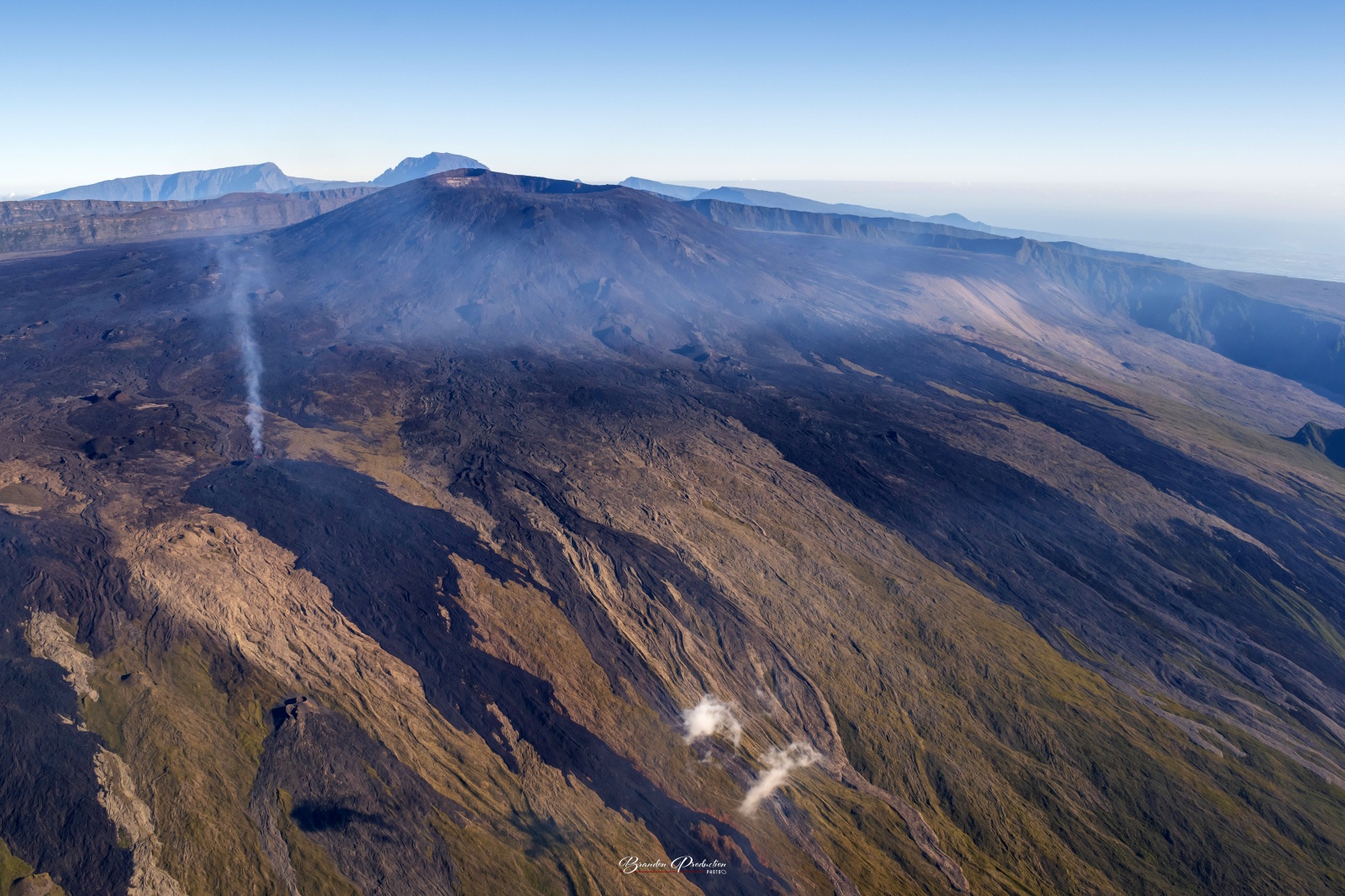
With the low surface activity, the morphology of the active volcanic cone – located southeast of the Enclos Fouqué at 1720 m altitude – hardly changes and the flow of the lava takes place mainly in lava tunnels. , even if flows are still visible at resurgence points and feed flows extending to distances of 1200 to 2000 m from the eruptive cone or up to 1000-1100 m altitude.
The flow front has not changed since July 5 and is now frozen. It is still 1.8 km from the road.
Low inflation of the summit area is still recorded, indicating a re-pressurization of the volcano’s feeder system with possible transfer of deep magma to the latter.
The seismic activity recorded under the summit zone remains weak. Thus over the last 24 hours, two superficial volcano-tectonic earthquakes have been recorded. This low seismic activity leads to a reduction in the risk of the appearance of a new crack and/or collapse in the crater, but does not mean that it can be excluded, as shown by the continuation of summit inflation.
Alert level: Alert 2-1 (eruption in the Enclos without any particular threat to the safety of people, property or the environment).
Source : OVPF
Photo : Imaz press / Brandon production.
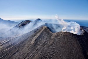
New Britain , Ulawun :
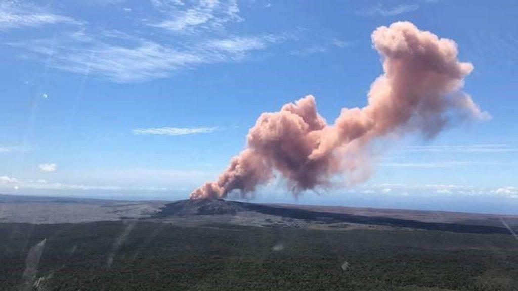
RVO reported that minor ash emissions at Ulawun began on 18 July, and during the morning of 19 July brown-to-gray emissions with low ash content were rising a few hundred meters above the crater rim and drifting SE. During 20-25 July steam-and-gas plumes with minor-to-moderate amounts of ash rose from the summit crater and rapidly dispersed. The emissions drifted in various directions, but mainly NW; minor ashfall was reported in areas downwind. Sulfur dioxide emissions were detected in satellite images on 21 and 24 July. Seismicity had begun increasing on 16 July, with RSAM values climbing at a slow but erratic rate, and peaking on 18 July. Afterwards RSAM values decreased and remained at low levels (150-200); seismicity was dominated by continuous volcanic tremors. RSAM values steadily increased to 550 during 04h00-14h00 on 22 July and fluctuated at moderate levels of 300-350 through 23 July. Values were variable on 24 July between values of 400 to 700. The Alert Level remained at Stage 1 (the lowest level on a four-level scale).
The symmetrical basaltic-to-andesitic Ulawun stratovolcano is the highest volcano of the Bismarck arc, and one of Papua New Guinea’s most frequently active. The volcano, also known as the Father, rises above the N coast of the island of New Britain across a low saddle NE of Bamus volcano, the South Son. The upper 1,000 m is unvegetated. A prominent E-W escarpment on the south may be the result of large-scale slumping. Satellitic cones occupy the NW and E flanks. A steep-walled valley cuts the NW side, and a flank lava-flow complex lies to the south of this valley. Historical eruptions date back to the beginning of the 18th century. Twentieth-century eruptions were mildly explosive until 1967, but after 1970 several larger eruptions produced lava flows and basaltic pyroclastic flows, greatly modifying the summit crater.
Source : RVO , GVP
Photo : Chris Samson , 26/06/2019
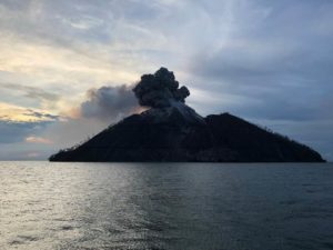
Indonesia , Awu :
Press release on the volcanic activity of G. Awu, July 26, 2023.
Mount Awu is located on Sangihe Island, which is part of the Sangihe Archipelago Regency in North Sulawesi Province.
The latest developments in the activity of the Awu volcano until July 26, 2023 are as follows:
There was an increase in seismicity which would be due to the movement of magma towards shallower depths. This is marked by an increase in the relatively high number of shallow volcanic earthquakes (type VTB) and deep volcanic earthquakes (type VTA). From July 12, 2023 to July 25, 2023 (14 days) 129 VTB earthquakes were recorded and 95 VTA earthquakes were recorded. The seismic energy has also increased, which is detected from the rising RSAM graph. However, so far no low frequency earthquakes or tremor vibrations have been detected which could be the initial symptom of an eruption.
Current visual observations show that surface activity is still in the form of gas emissions, no rocky material or ash has been brought to the surface. During the period from July 12 to 25, 2023 (14 days), the volcano was clearly visible until it was covered with fog. Through observations from CCTV cameras installed in the summit area, gas emissions were observed from the bottom of the crater/lava dome that were white with low intensity, rising about 10-100 meters above the summit. . The height of gas emissions decreases when the weather is sunny
Based on visual and instrumental monitoring through July 26, 2023, the Geological Agency said the activity level of Awu Volcano was still at Level II (WASPADA).
At Level II Activity Level (WASPADA), the public and visitors/tourists should not approach and conduct activities within 3 km of Mount Awu’s summit crater due to the potential danger of high concentrations of volcanic gas and ejection of rocks in the event of a sudden phreatic eruption, without being preceded by obvious signs of increased activity.
Source : PVMBG.
Photo : Auteur inconnu.
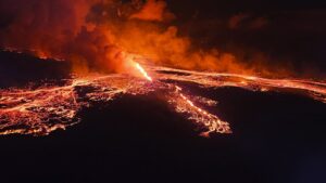
Iceland , Litli Hrútur :
July 24, 2023
Yesterday, July 23, we successfully completed an aerial photography flight over the lava at Litli-Hrútur.
Lava flow measurements (July 23)
Images were obtained from TF-CAD yesterday afternoon. The Institute of Natural Sciences made a terrain model from the photos. Measurements show that the average lava flow for the past five days (July 18-23) was about 8.0 m3/s.
The lava had reached 1.2 km2 and its volume was 12.4 million cubic meters. Lava expansion during this period was mainly eastward. At Meradalir, the lava edge has advanced 200m in the past five days. The progress of the lava towards the South is therefore now very slow.
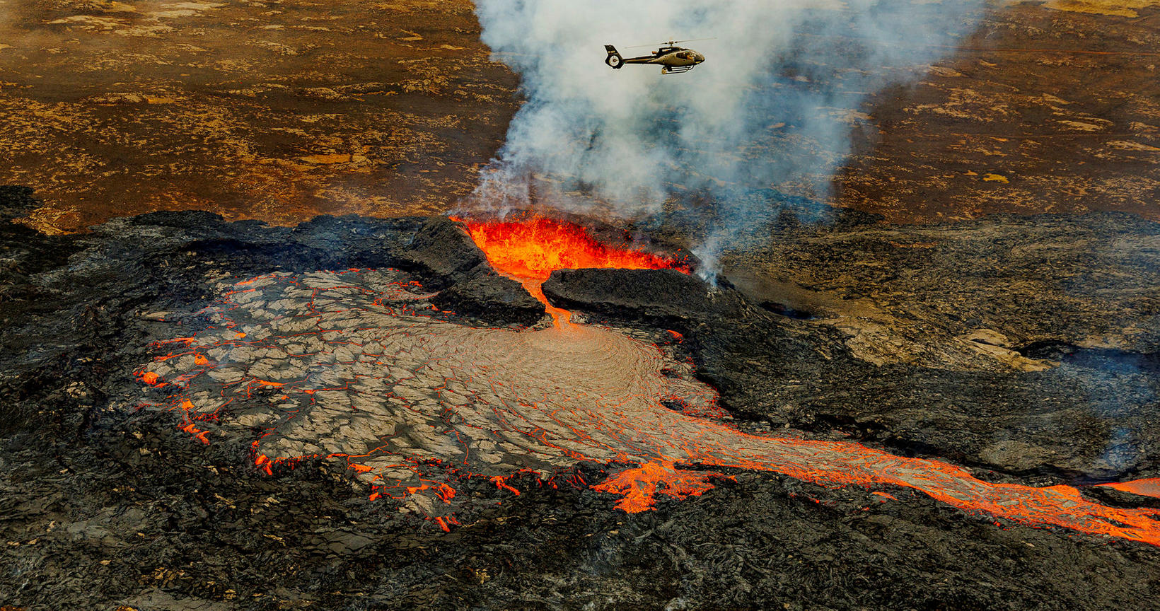
Measurements confirm that the lava flow slowly decreases over time.
The lava is now a bit larger than what formed in August of last year, and the volume is a bit bigger than it was during the 18-day eruption. Compared to the 2021 eruption, the volume is still only 8% of what happened then in six months. These first 13 days were far more powerful than the first weeks of the 2021 eruption.
Source : jardvis.hi.is/
Photo : mbl.is/Árni Sæberg