November 29 , 2022.
Hawaii , Mauna Loa :
Monday, November 28, 2022, 2:43 AM HST (Monday, November 28, 2022, 12:43 UTC)
19°28’30 » N 155°36’29 » W,
Summit Elevation 13681 ft (4170 m)
Current Volcano Alert Level: WARNING
Current Aviation Color Code: RED
The eruption continues at the summit of Mauna Loa. All vents remain restricted to the summit area. However, lava flows in the summit region are visible from Kona. There is currently no indication of any migration of the eruption into a rift zone.
The Volcano Alert Level and Aviation Color Code for Mauna Loa remains at WARNING/RED.
HVO is continuing to monitor conditions carefully and will issue additional notices as needed.
HVO/USGS Volcanic Activity Notice
Current Volcano Alert Level: WARNING
Current Aviation Color Code: RED
Issued: Monday, November 28, 2022, 7:20 AM HST
Source: Hawaiian Volcano Observatory
Notice Number: 2022/H603
Location: N 19 deg 28 min W 155 deg 36 min
Elevation: 13681 ft (4170 m)
Area: Hawaii
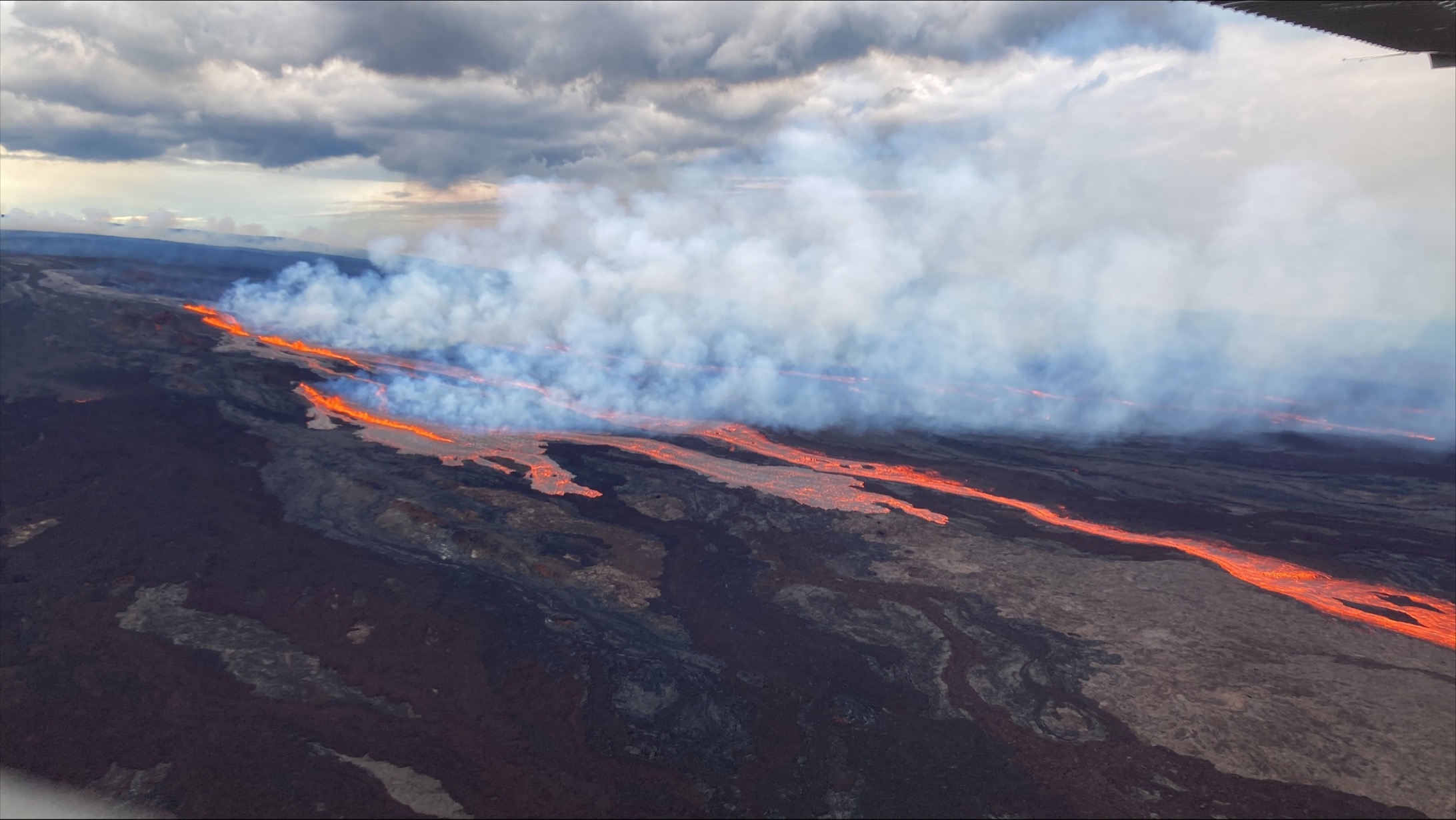
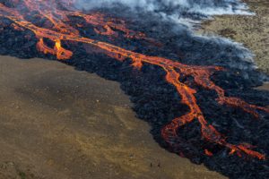
Aerial photos taken at 7:15 AM local time (HST) from Civil Air Patrol flight. Northeast rift zone eruption of Mauna Loa.
Volcanic Activity Summary:
The eruption of Mauna Loa has migrated from the summit to the Northeast Rift Zone where fissures are feeding several lava flows. HVO staff on an overflight at approximately 6:30 a.m. HST confirmed fissures at high elevations within Hawai‘i Volcanoes National Park are feeding lava flows upslope of the Mauna Loa Weather Observatory. Lava flows are not threatening any downslope communities and all indications are that the eruption will remain in the Northeast Rift Zone. Volcanic gas and possibly fine ash and Pele’s Hair may be carried downwind.
Residents at risk from Mauna Loa lava flows should review preparedness and refer to Hawai‘i County Civil Defense information for further guidance.
Based on past events, the early stages of a Mauna Loa rift zone eruption can be very dynamic, and the location and advance of lava flows can change rapidly.
HVO is in close consultation with emergency management partners and will monitor the volcano closely to provide further updates on activity.
Background:
Since the mid-19th century, Mauna Loa’s Northeast Rift Zone has erupted eight times: in 1843, 1852, 1855–1856, 1880–1881, 1899, 1935–1936, 1942, and 1984. Lava flows from the Northeast Rift Zone can travel in north, west, northwest, south, and southwest directions.
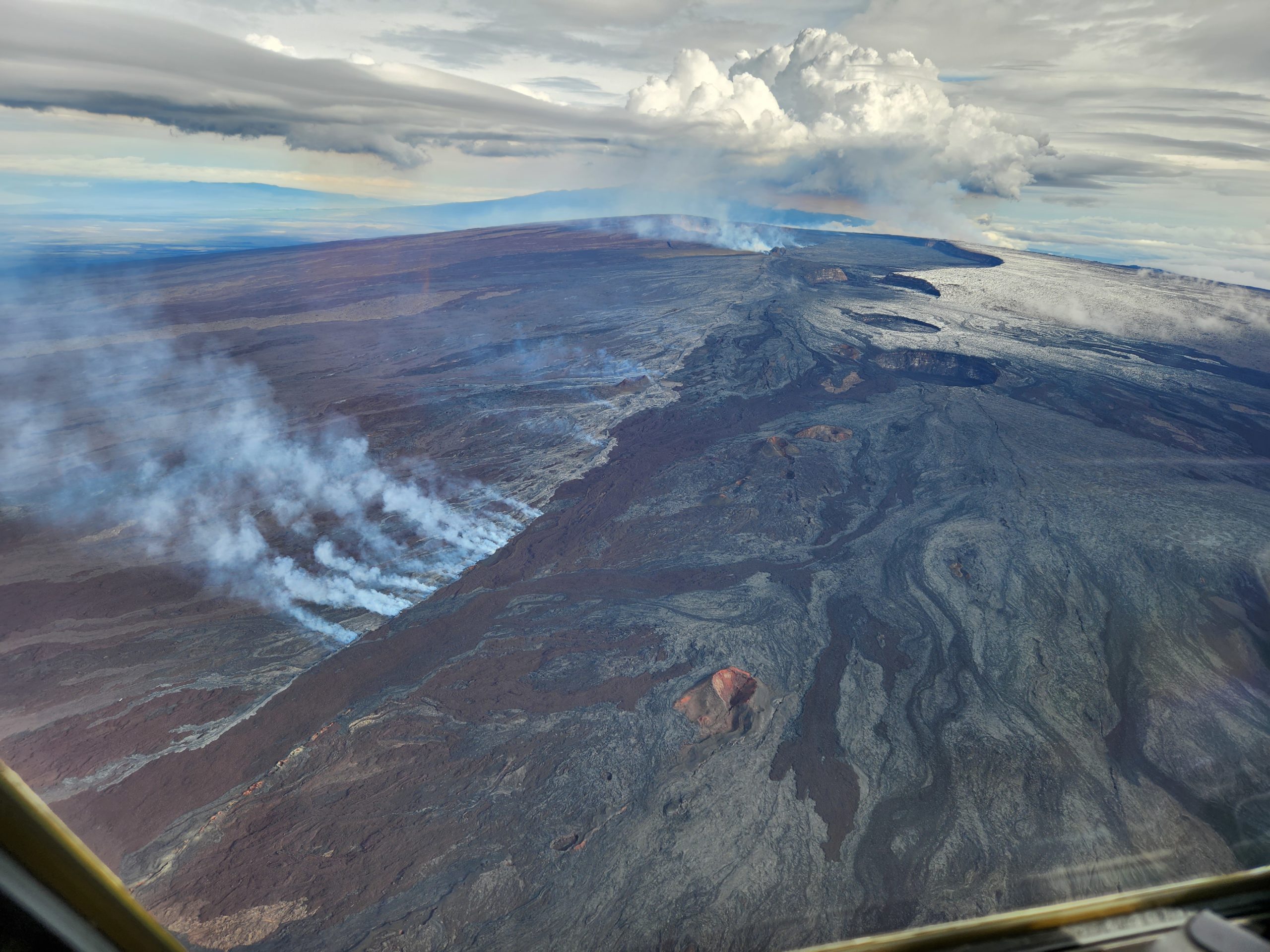
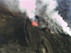
Aerial view of Mauna Loa summit with Lua Hou in the foreground followed by Lua Hohonu, South Pit, and Mokuʻāweoweo summit caldera. A small dusting of snow covers the ground east of the summit. The steaming fissure was active during the beginning of the eruption, but this morning the lava in the summit caldera had already cooled to a black color. The white plume in the background is rising from the fissures in the Northeast Rift Zone.
Monday, November 28, 2022, 4:55 PM HST (Tuesday, November 29, 2022, 02:55 UTC)
19°28’30 » N 155°36’29 » W,
Summit Elevation 13681 ft (4170 m)
Current Volcano Alert Level: WARNING
Current Aviation Color Code: RED
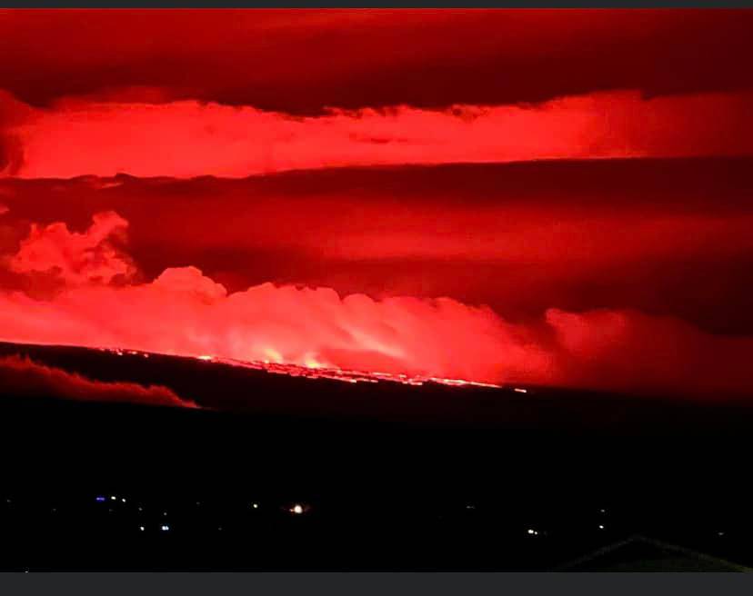
The eruption of Mauna Loa continues on the Northeast Rift Zone. Three fissures erupted and as of 1:30 PM, only the lowest of the three fissures was active. Estimates of the tallest fountain heights are between 100–200 ft (30 – 60 m), but most are a few yards (meters) tall. The fissures sent lava flows to the northeast and parallel to the rift zone. Lava flows from the two higher fissures moved downslope but stalled about 11 miles (18 km) from Saddle Road. Fissure 3 is currently feeding lava flows moving east parallel to the Northeast Rift Zone. These remain at above 10,000 feet elevation and over 10 miles (16 km) away from Saddle Road. We do not expect upper fissures to reactivate. However, additional fissures could open along the Northeast Rift Zone below the current location, and lava flows can continue to travel downslope.
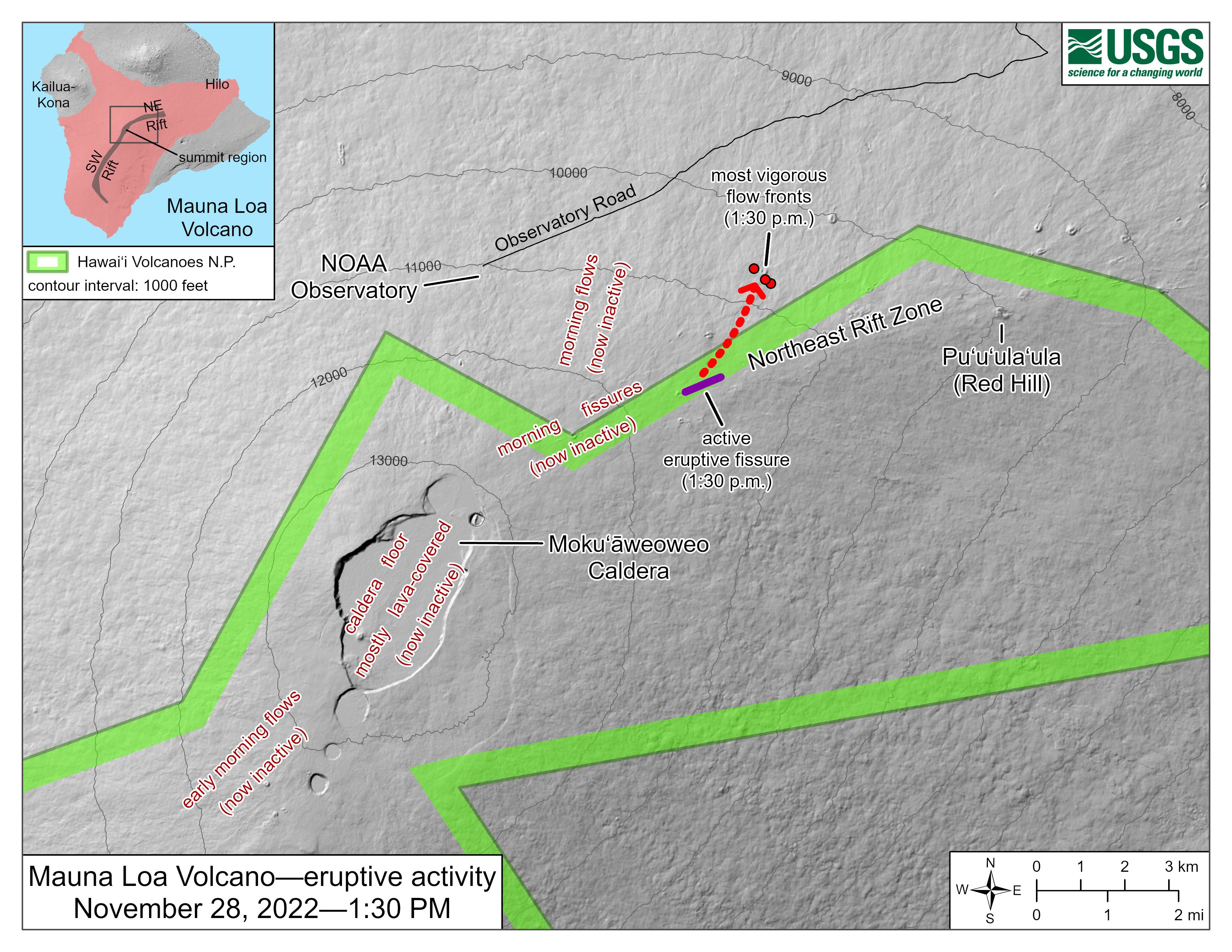
There is no active lava within Moku’āweoweo caldera, and there is no lava erupting from the Southwest Rift Zone. We do not expect any eruptive activity outside the Northeast Rift Zone. No property is at risk currently. There is a visible gas plume from the erupting fissure fountains and lava flows, with the plume primarily being blown to the Northwest.
Source : HVO
Photos : NaniWaialeale , USGS / J. Schmith , USGS .
El Salvador , San Miguel ( Chaparrastique) :
Special Report No. 14
WARNING. The San Miguel volcano is evolving in its activity, initiating an eruptive phase of intensity 1. Be attentive and do not carry out activities near the crater.
Date and time of publication: November 27, 2022, 10:00:00
SUMMARY: The San Miguel volcano changes activity, generating explosions of greater intensity and height across its central crater, initiating an eruptive phase of intensity 1 (on an explosive index scale of 0 to 8). The effects of these explosions on the outside are observed as:
Ejection of hot rocks near the crater due to explosions. As observed yesterday at 1:02 p.m., 4:42 p.m. and this morning at 7:18 a.m. and 8:02 a.m. Due to their greater height, volume of ash and ejection of rock, these explosions are classified as eruptions with a explosive index of 1.
Columns of gas, water vapor and visible ash which vary in height, to date the maximum heights observed exceed 1100 meters, approximately.
Vibrations on the slopes of the volcano which can generate unstable rockfalls both from inside the crater and from its surroundings.
We are monitoring the evolution of seismic behavior in the volcano, so we will constantly update if the activity of the volcano is changing from a phreatic to phreatomagmatic stage, that is, if signs of new magma are found. . Due to the increased activity recorded this afternoon, it is recommended within a radius of 5 kilometers to comply with the preparedness measures indicated by the National Civil Protection System; as well as identifying escape routes, making sure they are in good condition.

According to the monitoring of seismicity, gas concentration and characteristics of collected ash, this activity is attributed to the processes of contact of hot gases coming from the interior of the volcano with rocks saturated with infiltrated water (phreatic activity, mainly ), which generate the explosions with emissions of gas, ash, rocks and hot water vapor through the central crater. This behavior will continue for the next few days.
Since Tuesday, November 15, the San Miguel volcano, through its central crater, has exhibited intermittent explosions, accompanied by gas, ash, rocks and abundant water vapor. The total number of explosions recorded to date is 181, with a daily average of 14. The average height reached by the explosions was around 500 meters. The highest explosions observed reached about 1100 meters.
San Miguel Volcano monitoring parameters are detailed below:
Seismicity:
Regarding the seismicity recorded by the San Miguel volcanic station located on the northern flank at 1700m altitude (meters above sea level), we are currently monitoring the evolution of the recordings.
%2010.11.25.png)
Figure 1. Seismic record from the VSM station.
Gas:
Gas measurements taken in the field, with DOAS Mobile equipment, indicate average values of 283 tons per day of sulfur dioxide; the historic base threshold for the normal behavior of the San Miguel volcano is 300 tons per day. Spot measurements were made during the explosions, which reached values of 1200 tons per day, during one of the largest explosions.
Physical geology:
The samples collected from the ash deposits around the volcano, produced from the explosions, are composed mainly of fragments of pre-existing rocks and weathered deposits from the walls and fumaroles of the crater. These results indicate, so far, that these deposits correspond only to the drag of material from the walls of the conduit through which the gases are transported from the interior to the crater of the volcano, with no indication that there is a new transported magmatic material.
Parameters of the rest of the major volcanoes are below their baselines.
Source et photos : Marn
Peru , Sabancaya :
Analysis period: from November 21, 2022 to November 27, 2022, Arequipa, November 28, 2022.
Alert level: ORANGE
The Geophysical Institute of Peru (IGP) reports that the eruptive activity of the Sabancaya volcano remains at moderate levels, that is to say with the recording of an average of 35 daily explosions, with columns of ash and of gas up to 3.5 km altitude above the summit of the volcano and their subsequent dispersion. Therefore, for the following days, no significant change is expected in eruptive activity.
The IGP recorded and analyzed the occurrence of 337 earthquakes of volcanic origin, associated with the circulation of magmatic fluids inside the Sabancaya volcano. An average of 35 explosions was recorded daily, in addition to recording Volcano-Tectonic (VT) type events associated with rock fracturing inside the Sabancaya volcano.
Monitoring the deformation of the volcanic structure using GNSS techniques (processed with fast orbits) does not show any significant anomalies. However, in general, an inflation process was observed in the northern sector (surroundings of the Hualca Hualca volcano). Visual surveillance identified columns of gas and ash up to 3.5 km above the summit of the volcano, which were scattered towards the western, northeast and southwest sectors of Sabancaya . Satellite recordings have identified the presence of 4 thermal anomalies, with a maximum value of 7 MW, associated with the presence of a lava body on the surface of the volcano’s crater.
RECOMMENDATIONS
• Keep the volcanic alert level orange.
• Do not approach within a radius of less than 12 km from the crater.
Source : Cenvul
Photo : Ingemmet
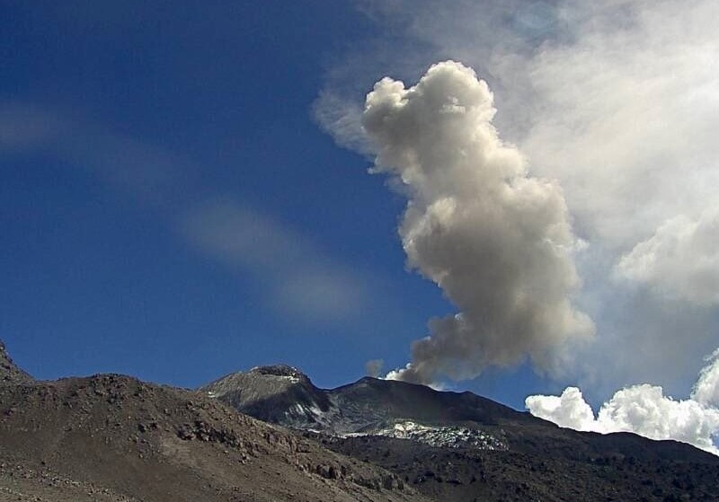
Kamchatka , Sheveluch :
VOLCANO OBSERVATORY NOTICE FOR AVIATION (VONA)
Issued: November 29 , 2022
Volcano: Sheveluch (CAVW #300270)
Current aviation colour code: ORANGE
Previous aviation colour code: orange
Source: KVERT
Notice Number: 2022-184
Volcano Location: N 56 deg 38 min E 161 deg 18 min
Area: Kamchatka, Russia
Summit Elevation: 3283 m (10768.24 ft), the dome elevation ~2500 m (8200 ft)
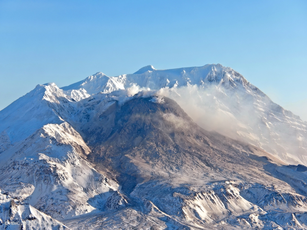
Volcanic Activity Summary:
A growth of the lava dome continues, a strong fumarole activity, an incandescence of the lava dome, explosions, and hot avalanches accompanies this process. Video data by KVERT showed an ash plume associated with hot avalanches collapses is extending for 10 km to the north-west of the volcano.
The extrusive eruption of the volcano continues. Ash explosions up to 10-15 km (32,800-49,200 ft) a.s.l. could occur at any time. Ongoing activity could affect international and low-flying aircraft.
Volcanic cloud height:
5500 m (18040 ft) AMSL Time and method of ash plume/cloud height determination: 20221129/0256Z – Video data
Other volcanic cloud information: Distance of ash plume/cloud of the volcano: 10 km (6 mi)
Direction of drift of ash plume/cloud of the volcano: NW
Time and method of ash plume/cloud determination: 20221129/0310Z – Video data
Source : Kvert.
Photo : I. Nuzhdaev, IVS FEB RAS
Mexico , Popocatepetl :
CENAPRED monitoring report on the Popocatépetl volcano, November 28
The Popocatépetl volcanic alert traffic light is in YELLOW PHASE 2.
The « CENAPRED urges NOT TO APPROACH the volcano and in particular the crater, because of the danger of falling ballistic fragments. »
During the last 24 hours, according to the monitoring systems of the Popocatépetl volcano, 88 exhalations, 231 minutes of tremor and a minor explosion have been detected.
Monitoring of the Popocatépetl volcano is carried out continuously 24 hours a day. Any changes in activity will be reported in a timely manner.

CENAPRED insistently reiterates the recommendation not to climb to the crater of the volcano because there is a possibility of explosions, as has been seen on several occasions in the past, which involve the emission of incandescent fragments and in the event of strong rains, to move away from the bottom of the ravines because of the danger of mudslides and debris.
Source et photo : Cenapred.