September 12 , 2022.
Hawaii , Kilauea :
19°25’16 » N 155°17’13 » W,
Summit Elevation 4091 ft (1247 m)
Current Volcano Alert Level: WATCH
Current Aviation Color Code: ORANGE
Activity Summary:
The summit eruption of Kīlauea Volcano, within Halemaʻumaʻu crater, continued over the past 24 hours. All recent eruptive activity has been confined to the crater. No significant changes have been observed at the summit or in either rift zone.
Halemaʻumaʻu Lava Lake Observations:
Eruption of lava from the western vent into the active lava lake and onto the crater floor continued over the past 24 hours. The active part of the lava lake showed continuous surface activity. Overflight measurements from August 16, 2022, indicated that the crater floor had seen a total rise of about 137 meters (449 feet), since the beginning of this eruption on September 29, 2021.
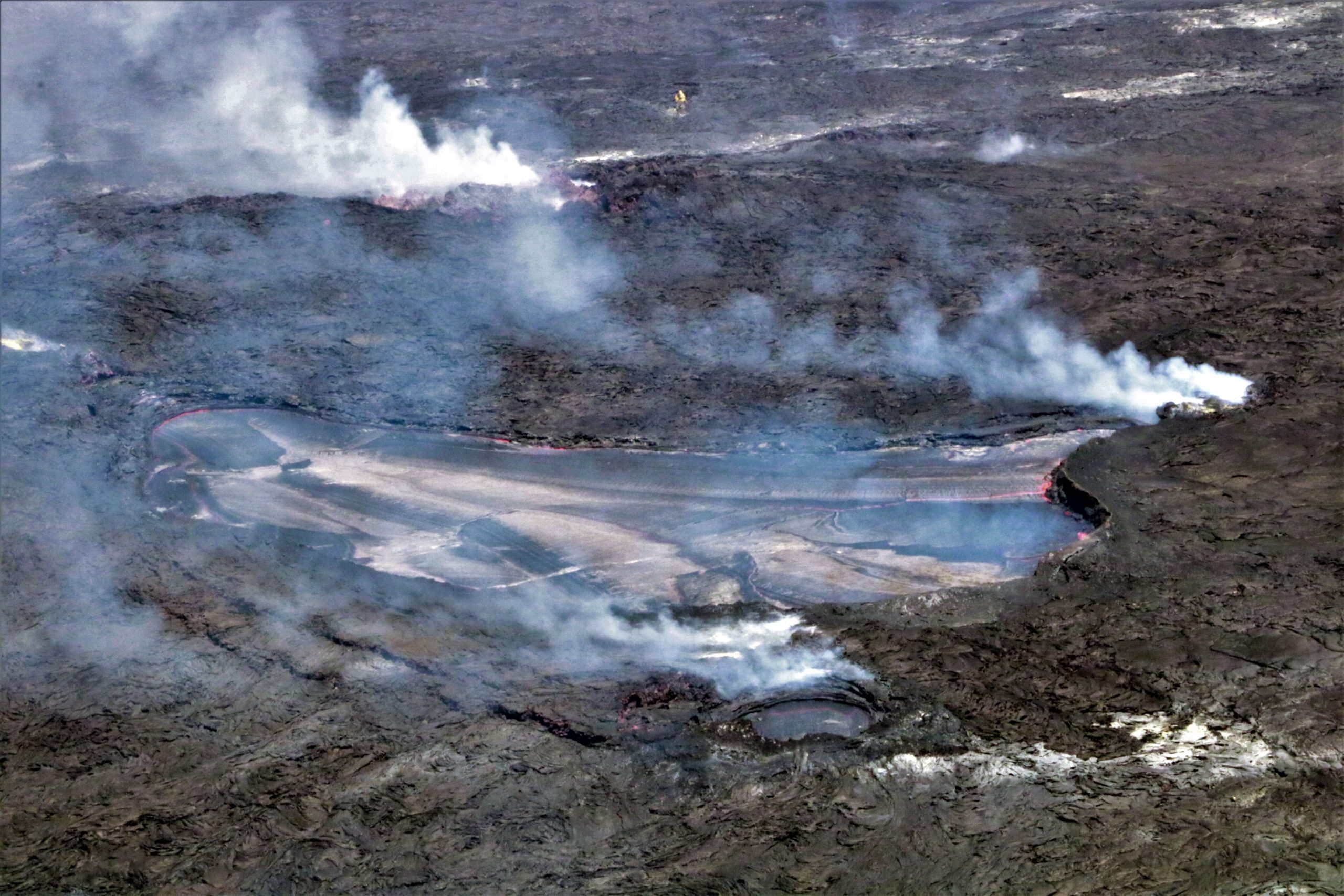
A telephoto view of the active lava lake within Halema‘uma‘u crater, at the summit of Kīlauea volcano. The active lava lake is approximately 3 acres (1 hectare) in area; however, lava flows from this eruption, which began on September 29, 2021, have covered approximately 282 acres (114 hectares).
Summit Observations:
Summit tiltmeters recorded relatively little ground deformation over the past 24 hours. Volcanic tremor remains above background levels. A sulfur dioxide (SO2) emission rate of approximately 2,000 tonnes per day (t/d) was measured on September 6, 2022.
Rift Zone Observations:
No unusual activity has been noted along the East Rift Zone or Southwest Rift Zone; low rates of ground deformation and seismicity continue along both. Measurements from continuous gas monitoring stations downwind of Puʻuʻōʻō in the middle East Rift Zone remain below detection limits for SO2, indicating that SO2 emissions from Puʻuʻōʻō are negligible.
Source : HVO.
Photo : USGS / K. Mulliken.
Iceland , Grimsey Islands :
Seismic activity at Grímsey increased again around midnight after calming somewhat down yesterday. Over 6000 earthquakes have been detected and the largest earthquake detected was a M4.9 on the 8th of September at 04:01. The largest earthquakes have been felt widely in the north of Iceland. The last large seismic swarm in this area was in February 2018.
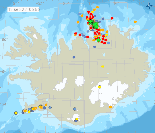
The offshore Tjörnes Fracture Zone is an oblique transform zone that separates the northern volcanic zone of Iceland from the Kolbeinsey Ridge, part of the Mid-Atlantic Ridge north of Iceland. A submarine eruption was reported during 1867-1868 at the SE part of the fissure system off the northern coast of Iceland along the Manareyjar Ridge immediately north of Manareyjar Island.
Sources : Vedur is , GVP.
Photo : Vedur is
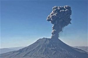
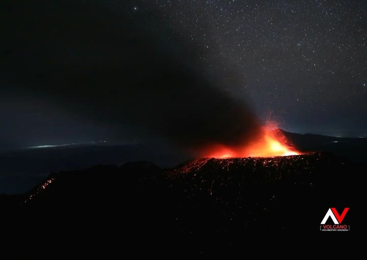
Indonesia , Ibu :
Mount Ibu erupted on Sunday, September 11, 2022 at 8:47 p.m. WIT with an ash column height observed at ± 600 m above the summit (± 1925 m above sea level). It is observed that the ash column is white / gray with a thick intensity towards the West. This eruption was recorded on a seismograph with a maximum amplitude of 26 mm and a duration of 70 seconds.
VOLCANO OBSERVATORY NOTICE FOR AVIATION – VONA
Issued : September 11 ,2022
Volcano : Ibu (268030)
Current Aviation Colour Code : ORANGE
Previous Aviation Colour Code : orange
Source : Ibu Volcano Observatory
Notice Number : 2022IBU58
Volcano Location : N 01 deg 29 min 17 sec E 127 deg 37 min 48 sec
Area : North Maluku, Indonesia
Summit Elevation : 4240 FT (1325 M)
Volcanic Activity Summary :
Eruption with volcanic ash cloud at 11h47 UTC (20h47 local).
Volcanic Cloud Height :
Best estimate of ash-cloud top is around 6160 FT (1925 M) above sea level, may be higher than what can be observed clearly. Source of height data: ground observer.
Other Volcanic Cloud Information :
Ash-cloud moving to west.
Seismicity:
It was recorded:
72 earthquakes of eruptions/explosions with an amplitude of 15 to 30 mm and a duration of 19 to 65 seconds.
42 avalanche earthquake, amplitude 2-14mm and duration 25-50 seconds.
18 emission earthquakes with an amplitude of 5 to 14 mm and a duration of 10 to 35 seconds.
10 harmonic tremors with an amplitude of 2 to 8 mm and a duration of 20 to 35 seconds.
12 shallow volcanic earthquakes with an amplitude of 8 to 14 mm and a duration of 9 to 14 seconds.
1 distant tectonic earthquake with an amplitude of 26 mm, S-P 12 seconds and a duration of 300 seconds.
Source : Magma Indonésie.
Photo : Andi volcano
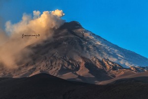
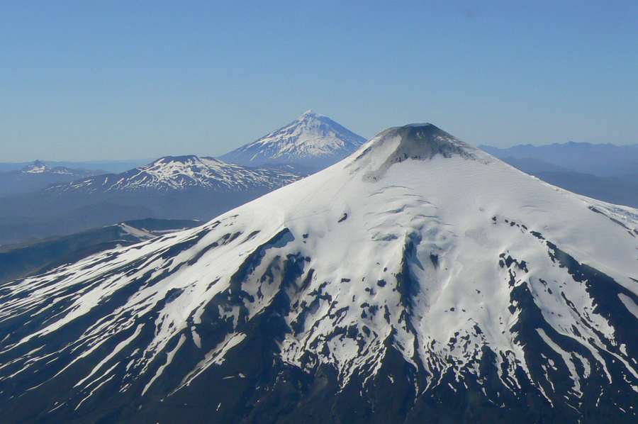
Chile , Villarica :
Seismology
The seismological activity of the period was characterized by the recording of:
-9 VT type seismic events, associated with rock fracturing (Volcano-Tectonics). The most energetic earthquake presented a value of local magnitude (ML) equal to 1.2, located 4.8 km east-southeast of the volcanic edifice, at a depth of 3.0 km from the crater.
-1449 LP-type seismic events, associated with fluid dynamics within the volcanic system (Long Period). The size of the largest earthquake estimated from the reduced displacement parameter (RD) was equal to 15 cm2.
-2 seismic events of the TR type, associated with sustained dynamics over time of the fluids inside the volcanic system (TRemor). The size of the largest earthquake estimated from the reduced displacement parameter (RD) was equal to 2 cm2.
Fluid Geochemistry
Data on sulfur dioxide (SO2) emissions obtained by optical differential absorption spectroscopy (DOAS) equipment, corresponding to the Los Nevados and Tralco stations, installed 10 km to the East-North-East (ENE) and 6 km east-southeast (ESE) of the active crater, respectively, showed an average value of 2,524 ± 386 t/d, with a maximum daily value of 5,304 t/d on August 11. According to the activity of the volcano, these values are higher than the levels considered normal.
Satellite thermal anomalies
During the period, 8 thermal alerts were recorded in the area associated with the volcano, with a maximum Volcanic Radiative Power (VRP) of 2 MW on August 10, 19 and 28, a value considered low according to data processed by Middle Infrared Observation. of Volcanic Activity (MIROVA). Through analysis of Sentinel 2L2A satellite images, 5 radiance anomalies were detected in the area associated with the crater on August 1, 3, 8, 21 and 29, with a maximum anomalous radiance area of 5400 m2 on August 28 .
Geodesy
According to the data delivered by 4 GNSS stations installed around the volcanic edifice, low magnitude displacements were observed, in addition to variations possibly related to the
presence of snow. There are NO significant signs of deformation that indicate changes in dynamics within the volcano. A recorded subsidence signal is maintained, with greater amplitude in stations east of the active crater, with a low rate and possibly linked to cyclical variations of an annual nature.

Surveillance cameras
The images provided by the fixed camera, installed near the volcano, recorded a regular degassing, with a maximum column height of 340 meters, on August 28. Nocturnal incandescence was observed during the period evaluated, on days when weather conditions permitted.
Satellite geomorphological analysis
From the photo interpretation of a high resolution image, Skysat type of August 22, 2022, it was observed inside the crater, identifying a subsidence of the lava lake with the formation of
a crust in its upper part and the existence of a crack where we observe the presence of molten material, the crack has an ellipsoidal shape, with a major axis of 6.7 m and a minor axis of 3.5 m , covering an area of 19 m2. On the other hand, on the internal walls of the conduit where there is snow cover, deposits of ash-sized pyroclasts are observed, probably associated with a remobilization of material. No block-sized pyroclasts are identified either inside or outside the crater.
Therefore, the Volcanic Technical Alert is maintained at:
GREEN TECHNICAL ALERT: Active volcano with stable behavior – There is no immediate risk
Source : Sernageomin
Photos : Ameriquedusud.org
Ecuador : Chiles / ( Cerro Negro) :
DAILY REPORT OF THE STATE OF THE CHILES VOLCANO, Sunday September 11, 2022.
Information Geophysical Institute – EPN.
Surface activity level: Very low, Surface trend: No change.
Internal activity level: Moderate, Internal trend: No change.
Seismicity: From September 10, 2022, 11:00 a.m. to September 11, 2022, 11:00 a.m.:
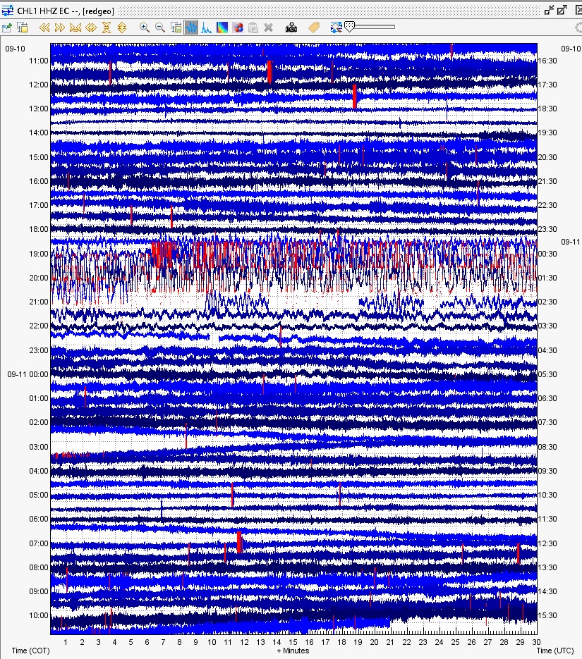
Seismogram of seismic station CHL1 09/11/2022
The reference station for seismic statistics has been transmitting without problems for the past 24 hours.
Tectonic Volcano (VT) 75
Long periods (LP): 2
Rains / Lahars:
There are no reports of rain in the volcano area.
Observation:
There are no direct observations towards the volcano.
Source et photo : IGEPN.