June 25 , 2022.
Russia / Kuril Islands , Chikurachki :
VOLCANO OBSERVATORY NOTICE FOR AVIATION (VONA)
Issued: June 23 / 25 , 2022
Volcano: Chikurachki (CAVW #290360)
Current aviation colour code: ORANGE
Previous aviation colour code: green
Source: KVERT
Notice Number: 2022-53
Volcano Location: N 50 deg 19 min E 155 deg 27 min
Area: Northern Kuriles, Russia
Summit Elevation: 1816 m (5956.48 ft)
Volcanic Activity Summary:
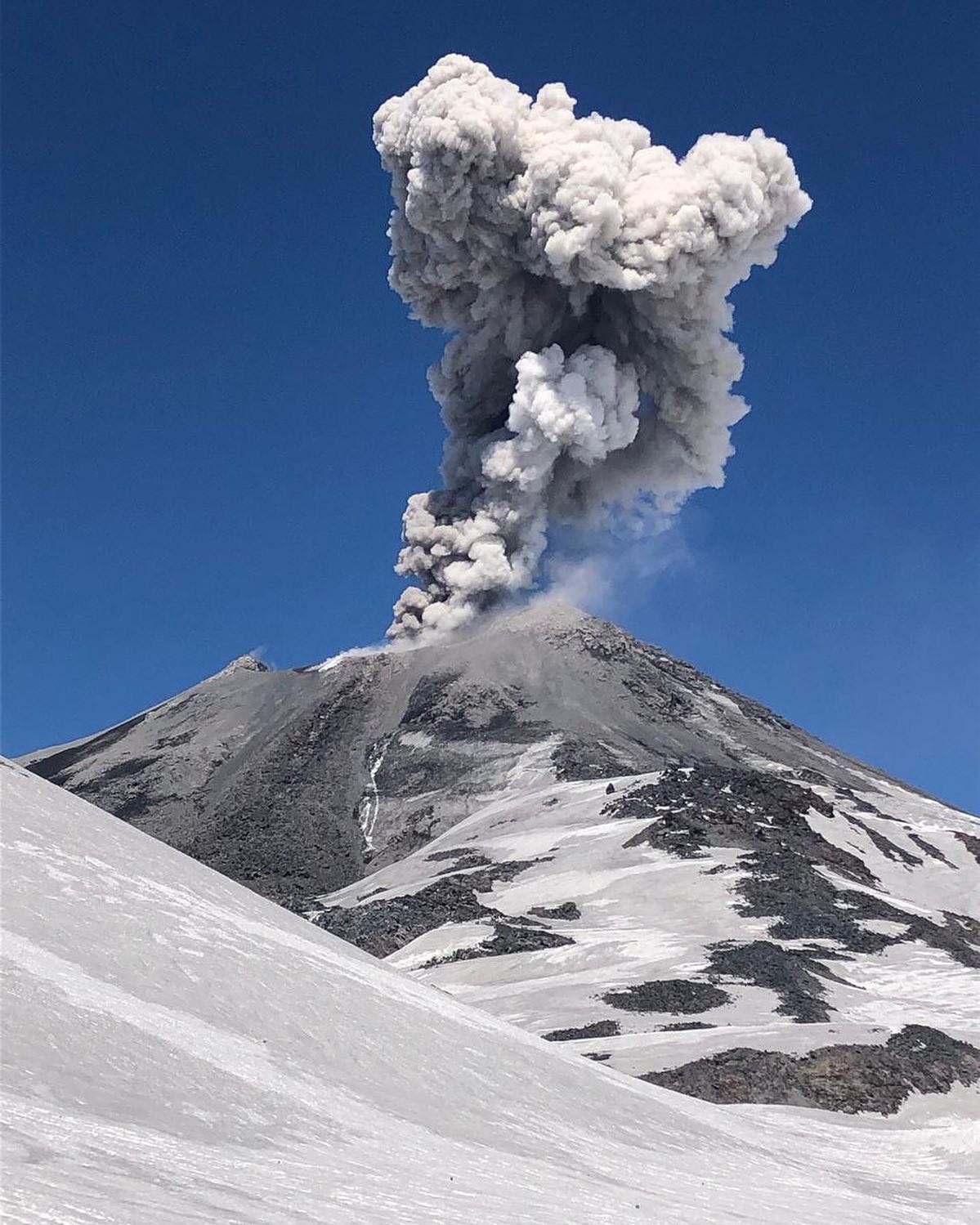
An activity of the volcano continues. Satellite data by KVERT showed the big ash cloud 14×30 km in size moved for 25 km to the southeast of the volcano.
An activity of the volcano continues. Ash explosions up to 6 km (19,700 ft) a.s.l. could occur at any time. Ongoing activity could affect low-flying aircraft.
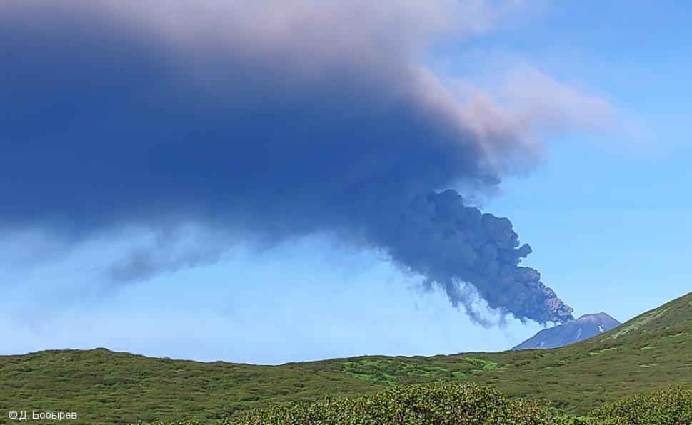
The explosive eruption of Chikurachki volcano began around 19:30 UTC on 23 June, the ash plume at 3 km a.s.l. moved southeast of the volcano.
Satellite data from KVERT shows the explosive eruption lasted from 19:30 UTC June 23 to 09:00 UTC June 24. The explosions sent ash up to 4.5 km above sea level, and the ash plume and later ash cloud moved about 786 km southeast of the volcano on 23 and June 24.
Volcanic cloud height:
3000 m (9840 ft) AMSL Time and method of ash plume/cloud height determination: 20220623/2050Z – Himawari-8
Other volcanic cloud information:
Distance of ash plume/cloud of the volcano: 25 km (16 mi)
Direction of drift of ash plume/cloud of the volcano: ESE / azimuth 110 deg
Time and method of ash plume/cloud determination: 20220623/2050Z – Himawari-8
Source : Kvert.
Photo : D. Bobyrev.
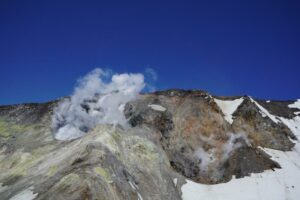
Chile , Nevados de Chillan :
Seismology
The seismological activity of the period was characterized by the recording of:
17 volcano-tectonic (VT) earthquakes, seismicity associated with brittle rupture processes; the most energetic earthquake had a local magnitude (ML) equal to 2.3, whose location was estimated at a distance of 4.1 km east-south-east of the active crater. Compared to previous months, a decrease in the production of this type of seismicity has been observed.
Long period (LP), explosion (EX) and tremor (TR) seismicity continued to be recorded, associated with fluid dynamics within the volcanic system. 608 LP-type earthquakes were classified, including 173 linked to explosions at surface level, due to the presence of acoustic waves and/or gaseous emissions, often with particle input. The size of the largest LP earthquake estimated from the Reduced Displacement (DR) parameter reached a value equal to 237 cm2, causing a very weak response towards the atmosphere and with it, an acoustic wave of 0.16 Pascals, reduced to 1km as reference. Regarding TR type seismicity, 221 episodes were identified, the most important of which reached a DR of 125 cm2. The current eruptive phase is characterized by low seismic energies related to fluid dynamics, but with a greater presence of TR type events, contrasting with the periods of greater volcanic activity which were characterized by the generation of explosive events more energetic.
Fluid Geochemistry
Data on sulfur dioxide (SO2) emissions obtained by optical differential absorption spectroscopy (DOAS) equipment, corresponding to the Philippi and Chillán stations, installed 1.5 km to the South-South-East (SSE) and 2.7 km east-southeast (ESE) of the active crater, respectively, showed an average value of 453 ± 85 t/d, with a maximum daily value of 767 t/d, recorded on 8 June. SO2 levels are still above baseline levels, which is consistent with the presence of Dome 4, located inside the active Nicanor crater.
Satellite thermal anomalies
Three thermal alerts were recorded in the area associated with the volcanic complex during the period, with a Volcanic Radiative Power (VRP) of less than 1 MW, a value considered low according to the data processed by the Medium Infrared Observation of the Volcanic Activity (MIROVA).
At the same time, according to the analytical processing of satellite images (Sentinel 2-L2A in combination of false color bands), luminance anomalies were observed on June 9 and 12.
Geodesy
According to the data provided by the geodetic network composed of 5 GNSS stations and 3 electronic inclinometers, which makes it possible to measure the deformation in the complex, it is observed that the deflationary trend is maintained, identified mainly in the GNSS stations. An increase in subsidence rates is observed, compared to the previous period, with maximum values reaching 0.7 cm/month.
Surveillance cameras
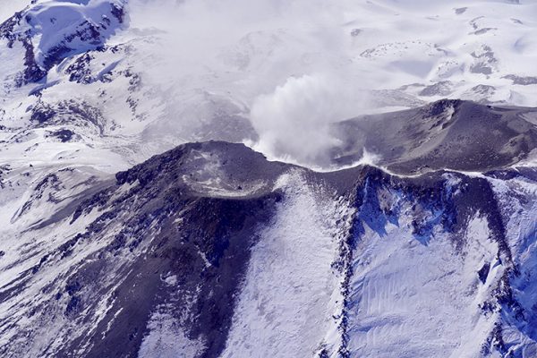
Explosive surface activity was recorded from the active crater, with the generation of eruptive columns with little or no pyroclastic content. The highest column heights reached 820 m above crater level, without generation of pyroclastic flows. Regarding the activity with incandescence, it remained at moderate to low levels, subject to the crater and with a maximum height close to 150 m on June 12.
Satellite geomorphological analysis
From analysis with Planet Scope OrthoTile and Sentinel 2 L2A satellite images, the permanence of a dome-like effusive body nested in the active crater (Dome 4) was observed, with minor variations in its area towards the western edge, suggesting that the low growth rate observed previously is maintained.
On the other hand, the detailed analysis of the images of Planet OrthoTile shows the simultaneous action of two emission centers in the area of dome 4, which are associated with the activity coming from the cracks previously observed, on and around the same dome. No difference was identified between the eruptive dynamics of each center during this evaluation period, in both cases, eruptive columns with low to zero pyroclastic content were recorded.
According to Sentinel 2 L2A false-color images, an area of anomalous thermal radiation is indicated, coinciding with Dome 4, with no major variations in its spatial distribution from what has been observed previously. Due to weather conditions, only two of these satellite images were available, with adequate visibility.
Source : Sernageomin
Read the article : https://rnvv.sernageomin.cl/rnvv/TI_Santiago_prod/reportes_LB/2022/RAV_20220624_%C3%91uble_v11.pdf
Photos : @nluengov , Ingemmet.
Indonesia , Merapi :
Mount Merapi activity report from June 17 to 23, 2022
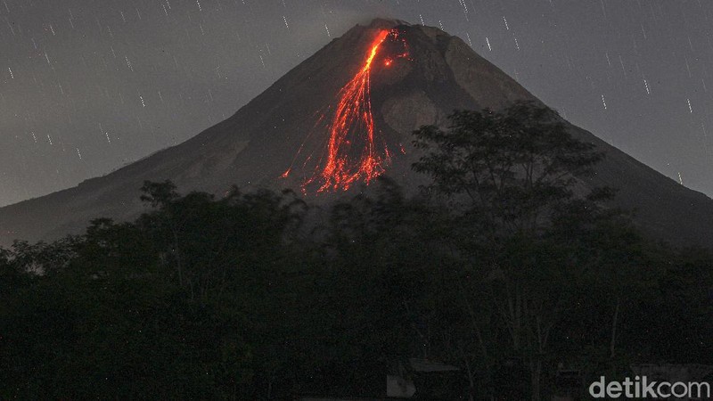
– This week, 70 lava avalanches were observed in a southwesterly direction, descending the Bebeng River with a maximum sliding distance of 1800 m.
– For the southwest dome, there is no change in the height of the dome. For the central dome, no significant morphological change was observed. According to photo analysis, the volume of the Southwest lava dome is 1,551,000 m3 and that of the central dome is 2,582,000 m3.
Seismicity:
This week, the seismicity of Mount Merapi recorded:
1 shallow volcanic earthquake (VTB),
62 multi-phase earthquakes (MP),
624 avalanche earthquakes (RF),
13 emission earthquakes (DG),
7 tectonic earthquakes (TT).
1 low frequency earthquake (LF)
– The intensity of seismicity this week is still quite high.
Mount Merapi’s deformation, which was monitored using EDM this week, showed a distance shortening rate of 0.2 cm/day.
Rainfall intensity of 23 mm/hour is recorded for 80 minutes at Kaliurang Post on June 18, 2022. No reports of lahars or additional flow in rivers that originate at Mount Merapi.
Conclusion:
1. Merapi volcanic activity is still quite high in the form of effusive eruption activity. The state of the activity is defined at the « SIAGA » level.
2. The current potential danger is lava avalanches and hot clouds in the South-South-West sector covering the Boyong River for a maximum of 5 km, the Bedog River, Krasak, Bebeng for a maximum of 7 km. The Southeast sector covers the Woro River for a maximum of 3 km and the Gendol River for a maximum of 5 km. Meanwhile, the ejection of volcanic material in the event of an explosive eruption can reach a radius of 3 km around the summit.
The public should not carry out any activity in potentially dangerous areas, anticipate disturbances due to volcanic ash from the Merapi eruption and be aware of the dangers of lahars, especially when it rains around Merapi.
Source : BPPTKG.
Photo : Detik .com
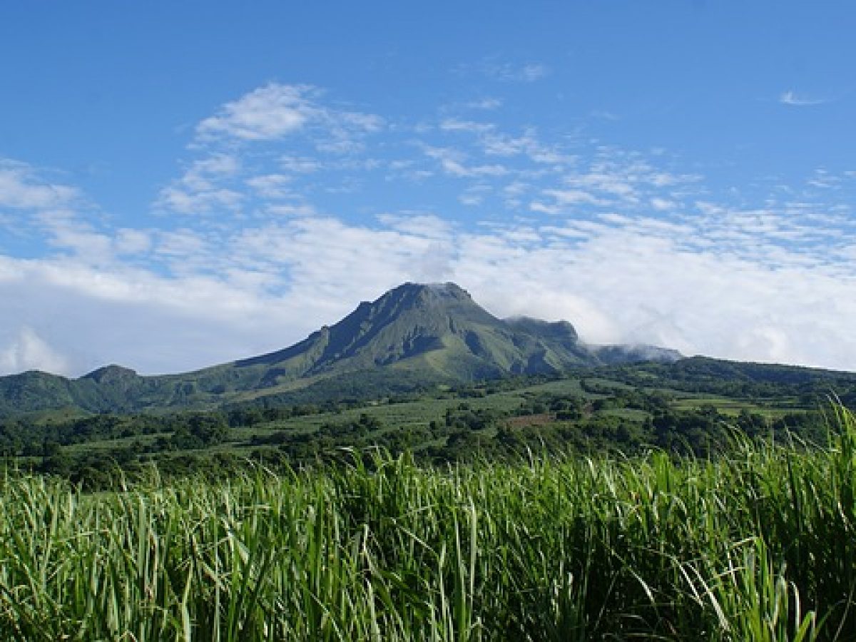
La Martinique , Mount Pelée :
Weekly report on the activity of Mount Pelée for the period from June 17, 2022 to June 24, 2022.
Between June 17, 2022 at 4 p.m. (UTC) and June 24, 2022 at 4 p.m. (UTC), the OVSM recorded at least 5 volcano-tectonic earthquakes including:
3 Earthquakes of magnitude less than 0.1. These low-energy earthquakes were located inside the volcanic edifice between 0.5 and .9 km deep below the surface. This superficial volcano-tectonic seismicity is associated with the formation of micro-fractures in the volcanic edifice.
2 earthquakes with a magnitude of 0.8 and 0.6, located respectively 6.8 km and 11.8 km deep below the surface, about 9 km away north-northwest of Le Prêcheur and 6 km distance to the North-North-West of Carbet. This earthquake could be associated with fracturing inside the Caribbean plate located under the volcanic edifice.
None of these earthquakes were felt by the population.
The zone of degassing at sea at shallow depth between St Pierre and le Prêcheur is still observed. The IGP took fluid samples in order to understand the origin of this degassing and to assess its possible relationship with the Mount Pelée hydrothermal system.
An extension of two areas of degraded vegetation located between Morne Plumé and the Rivière Chaude was observed during a helicopter flight carried out on February 9, with the support of the Dragon 972, and confirmed by analysis of satellite images.
The alert level remains YELLOW: vigilance.
Source : Direction de l’OVSM IPGP.
Photo : Antilles prestige
Indonesia , Ili Lewotolok :
FRIDAY, JUNE 24, 2022, Ili Lewotolok Volcano
Mount Ili Lewotolok erupted on Friday June 24, 2022 at 10:35 p.m. WITA. No visual rash was observed. This eruption was recorded on a seismograph with a maximum amplitude of 34 mm and a duration of 61 seconds.
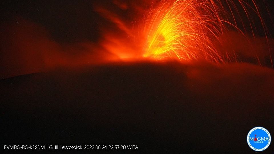
Current Aviation Color Code: ORANGE
Previous Aviation Color Code: orange
Source: Ili Lewotolok Volcano Observatory
Volcano location: S 08 deg 16 min 19 sec E 123 deg 30 min 18 sec
Region: East Nusa Tenggara, Indonesia
Summit elevation: 4554 FT (1423 M).
Recommendation
Based on the results of a thorough analysis and assessment, the activity level of the Ili Lewotolok volcano is still at level III (SIAGA) with new recommendations adapted to the latest potential dangers.
Source : Magma Indonésie .