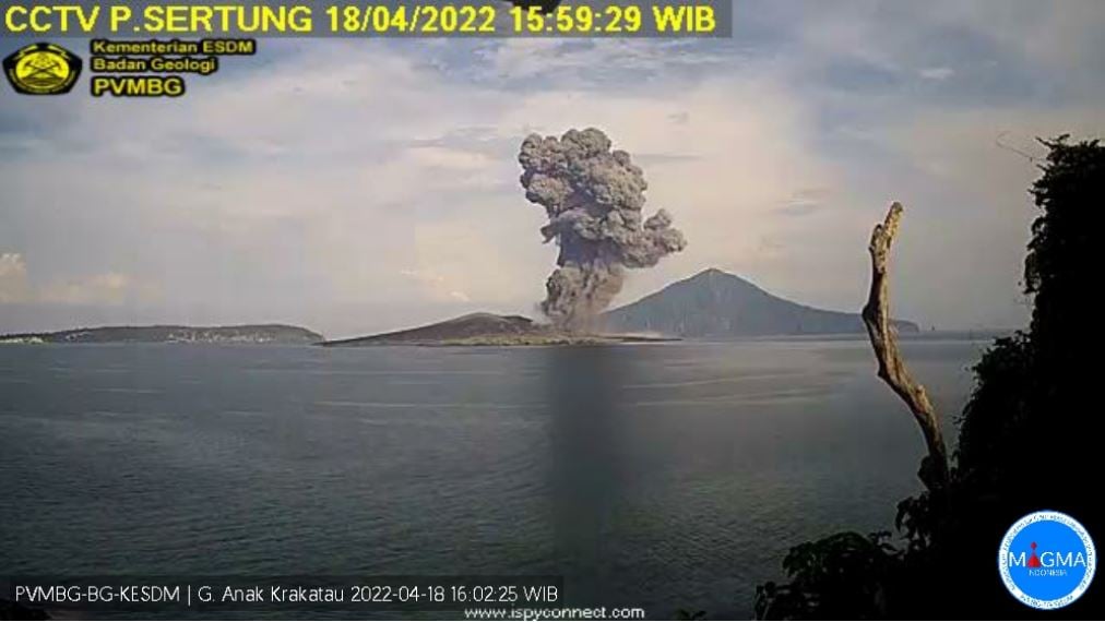
April 2022.
Indonesia , Anak Krakatau :
VOLCANO OBSERVATORY NOTICE FOR AVIATION – VONA
Issued : April 18 , 2022 .
Volcano : Anak Krakatau (262000)
Current Aviation Colour Code : ORANGE
Previous Aviation Colour Code : orange
Source : Anak Krakatau Volcano Observatory
Notice Number : 2022KRA37
Volcano Location : S 06 deg 06 min 07 sec E 105 deg 25 min 23 sec
Area : Lampung, Indonesia
Summit Elevation : 502 FT (157 M)
Volcanic Activity Summary :
Eruption with ash clouds at 08:58 UTC (15:58 local time). The eruption lasted for 68 seconds.
Volcanic Cloud Height :
Best estimate of ash-cloud top is around 3702 FT (1157 M) above sea level, may be higher than what can be observed clearly. Source of height data: ground observer.
Other Volcanic Cloud Information :
Visuals directly from the cctv were observed eruptions with the color of the thick grey-black eruption smoke 1000m from the top of the volcano, the wind direction slowly to the southwest.
Remarks :
Eruption recorded on seismogram with maximum amplitude 68 mm and maximum duration 68 second.
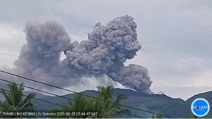
Mount Anak Krakatau (GAK) erupted seven times in April 2022. The lowest eruption was 700 meters above the peak of the summit. Then the highest eruption, reaching 1,000 meters above the mountain peak. The activity level remains at 2 / waspada, with the recommendation not to enter the 2 km zone around the crater.
Source : Magma Indonésie . CNN Indonésie .
Peru , Sabancaya :
Analysis period: from April 11, 2022 to April 17, 2022, Arequipa, April 18, 2022.
Alert level: ORANGE
The Geophysical Institute of Peru (IGP) reports that the eruptive activity of the Sabancaya volcano remains at moderate levels, that is to say with the recording of an average of 46 daily explosions, with columns of ash and of gas up to 3.4 km altitude above the summit of the volcano and their subsequent dispersion. Therefore, for the following days, no significant change is expected in eruptive activity.
The IGP recorded and analyzed the occurrence of 226 earthquakes of volcanic origin, associated with the circulation of magmatic fluids inside the Sabancaya volcano. An average of 46 explosions was recorded daily, in addition to recording Volcano-Tectonic (VT) type events associated with rock fracturing inside the Sabancaya volcano.

Monitoring the deformation of the volcanic structure using GNSS techniques (processed with fast orbits) does not show any significant anomalies. However, in general, an inflation process was observed in the northern sector (surroundings of the Hualca Hualca volcano). Visual surveillance identified columns of gas and ash up to 3.4 km above the summit of the volcano, which were dispersed towards the East, South-East, South, North-East and North of Sabancaya. Satellite recordings have identified the presence of 8 thermal anomalies, with a maximum value of 58 MW, associated with the presence of a lava body on the surface of the volcano’s crater.
RECOMMENDATIONS
• Keep the volcanic alert level orange.
• Do not approach within a radius of less than 12 km from the crater.
Source : Cenvul
Photo : Zintia Roxana Fernández Licla.
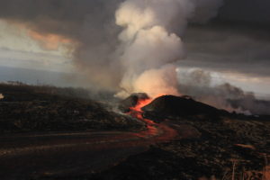
Chile , Laguna del Maule :
Laguna del Maule volcanic complex
SEISMOLOGY
577 VT type seismic events associated with rock fracturing (Volcano-Tectonics) were recorded.
The most energetic earthquake presented a value of Local Magnitude (ML) equal to 2.4, located 3.8 km to the East-South-East of the volcanic edifice, at a depth of 6.8 km by relative to the center of the lagoon.
An LP-type seismic event was recorded, associated with fluid dynamics within the volcanic system (Long Period type). The size of the earthquake estimated from the reduced displacement parameter (RD) was equal to 3.0 cm2.
FLUID GEOCHEMISTRY
No anomalies were reported in the emissions of sulfur dioxide (SO2) into the atmosphere in the area near the volcanic complex, according to data published by the Tropospheric Monitoring Instrument (TROPOMI) and the Ozone Monitoring Instrument (OMI) Sulfur Dioxide Group (http://so2.gsfc.nasa.gov/).
SATELLITE THERMAL ANOMALIES
During the period, no thermal alert was recorded in the area associated with the volcanic complex, according to data processed by the mid-infrared observation of volcanic activity (MIROVA) (http://www. mirovaweb.it/) and through the analysis processing of Sentinel 2-L2A satellite images, in combination with false color bands.

GEODESY
According to the data obtained from the geodetic monitoring network installed in the complex (5 GNSS stations and 4 electronic inclinometers, IE), it was observed that the monitored inflationary process has been continuing since 2012, with rates of rise slightly lower than the recorded average Last year. For 30 days, the maximum uplift has continued to be recorded at the GNSS MAU2 station, in the southwestern sector of the lagoon, with a rate of 2.1 ± 0.2 cm/month. The data obtained with the EI show variations without relevant trends. On the other hand, the Sentinel1 radar satellite images, processed by the radar interferometry technique, did not show any significant variations in the deformation pattern for the last period.
SURVEILLANCE CAMERAS
The images provided by the fixed camera installed near the complex did not record any degassing columns or variations linked to surface activity.
Activity remained at levels considered low, suggesting stability of the volcanic system. The volcanic technical alert remains in: GREEN TECHNICAL ALERT: Active volcano with stable behavior – There is no immediate risk
Observation: a zone of potential volcanic danger is considered to be that contained within a radius of 1 km, around the center of passive CO2 degassing.
Source : Sernageomin.
Photo : Dr Katie Keranen.
Ecuador , Sangay / Reventador :
DAILY REPORT OF THE STATE OF SANGAY VOLCANO, Monday April 18, 2022.
Information Geophysical Institute – EPN.
Surface Activity Level: High, Surface Trend: No change.
Internal activity level: High, Internal trend: No change.
Seismicity: From April 17, 2022, 11:00 a.m. to April 18, 2022, 11:00 a.m.:
Explosion (EXP) 60
Long Periods (LP) 50
Emission Tremors (TREMI ) 15
Harmonic Tremors: 2
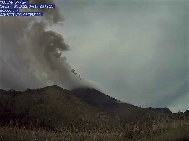
Rains / Lahars:
Thanks to the Windy system, 0.2 mm of rain was recorded in the area. **In the event of heavy rains, these could remobilize the accumulated materials, generating mudslides and debris that would descend on the flanks of the volcano and flow into the adjacent rivers.**
Emission / ash column:
Several gas and ash emissions were observed, with heights of less than 2 km, above the level of the crater, in a westerly direction. The Washington VAAC reported ash emissions at 870 and 1,770 meters above the summit, trending west and northwest.
Other Monitoring Parameters:
The FIRMS satellite system recorded 112 thermal alerts in the past 24 hours.
Observation:
The volcano area was partially cleared yesterday afternoon and early today; the rest of the time it remained mostly cloudy.
Alert level: Orange.
——————————————————————————————
DAILY REPORT OF THE STATE OF THE REVENTADOR VOLCANO, Monday April 18, 2022.
Information Geophysical Institute – EPN.
Surface Activity Level: High, Surface Trend: No change.
Internal activity level: Moderate, Internal trend: No change.
Seismicity: From April 17, 2022, 11:00 a.m. to April 18, 2022, 11:00 a.m.:
Explosion (EXP) 35
Long Periods (LP) 50
Emission Tremors (TREMI ) 15
Harmonic Tremors: 5
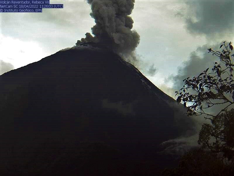
Rains / Lahars:
Through the Windy system, rains reaching 1mm were recorded in the area.
Emission / ash column:
Emissions of gas and ash were observed reaching up to 900 meters above the level of the crater, in a westerly direction. Washington’s VAAC reported ash emission 988 meters above the summit, heading northwest.
Other Monitoring Parameters:
No thermal anomaly was recorded on the FIRMS and MIROVA satellite systems.
Observation:
A glow was observed at the top during the night. At the time of publication of the report, the area is cloudy.
Alert level: Orange.
Source : IGEPN
Photos : IGEPN .
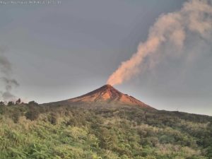
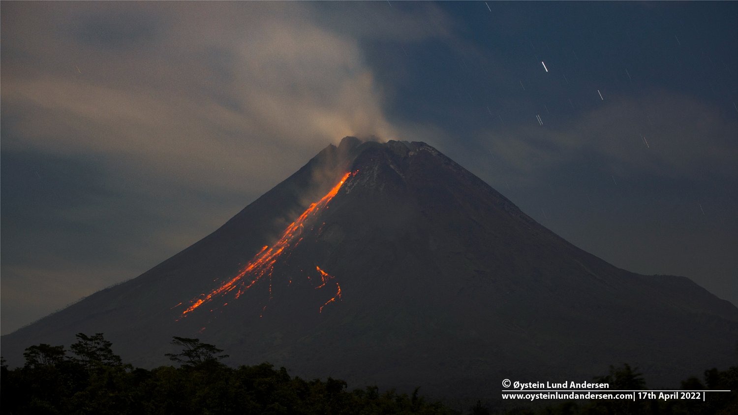
Indonesia , Merapi :
Merapi activity report from April 8 to 14, 2022.
– This week, 112 lava avalanches were observed in a dominant South-West direction towards the Bebeng River with a maximum slip distance of 2,000 m.
– Aerial photos from drone surveys show two avalanche sources in the Southwest Dome, both pointing towards Kali Bebeng. Meanwhile, the source of the avalanches in the crater’s central lava dome is in the area of the former avalanche on March 9-10, 2022.
– Based on the photo analysis of the camera station, the volume of the Southwest lava dome is 1,672,000 m3 and the central dome is 2,582,000 m3.
Seismicity:
This week, the seismicity of Mount Merapi recorded:
1 low frequency (LF) earthquakes,
17 shallow volcanic earthquakes (VTB),
47 multi-phase earthquakes (MP),
765 avalanche earthquakes (RF),
4 emission earthquakes (DG),
7 tectonic earthquakes (TT).
– The intensity of seismicity this week is still quite high.
Mount Merapi’s deformation that was monitored using EDM this week showed a distance shortening rate of 0.2 cm/day.
– Rainfall intensity was 52 mm/hour for 50 minutes at Kaliurang Post on April 13, 2022. There were no reports of lahars or additional flow in the rivers that originate at Mount Merapi.
Conclusion:
1. The volcanic activity of Mount Merapi is still quite high in the form of effusive eruption activity. The state of the activity is defined at the « SIAGA » level.
2. The current potential danger is lava avalanches and hot clouds in the South-South-West sector covering the Boyong River for a maximum of 5 km, the Bedog River, Krasak, Bebeng for a maximum of 7 km. The Southeast sector covers the Woro River for a maximum of 3 km and the Gendol River for a maximum of 5 km. Meanwhile, the ejection of volcanic material in the event of an explosive eruption can reach a radius of 3 km around the summit.
Source : BPPTKG
Photo : Oystein Lund Andersen.