April 15 , 2022.
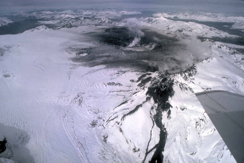
Ecuador , Sangay :
Activity from April 4 to 6, 2022
ABSTRACT
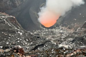
The eruptive activity of the Sangay volcano increased slightly between April 4 and 6, 2022. The weeks preceding this increase, a slight deformation of the volcano was observed, as well as an increase in degassing. The eruption was characterized by increased emission of lava flows from the North vent on April 4 and the formation of a persistent thin volcanic cloud reaching 1.7 km above the crater and trending west on April 5. april . This activity was followed by a low frequency tremor which continued until April 6th. Although the ash cloud reached up to 650 km away, heading west, between April 5 and 6, only a slight ash fall was reported in the canton of Guamote, province of Chimborazo. Based on the information available on the event, it is estimated that the volcanic explosivity index was 1 and is classified as a low explosive eruption. This type of activity is common on the Sangay volcano, which maintains internal and surface activity at levels classified as high.

Deformation
The deformation analysis was carried out with Sentinel-1 ascending orbit images from October 1, 2021 to April 4, 2022, with the SBAS (Small Baseline) method. In the time series, a negative trend is observed since March 10. This trend is interpreted as the emission of matter and gas from the volcano, which generates a « deflation ». Since March 10, the following negative deformations are quantified at the reference points: North (N): -1.72 cm; North-West (NW): -1.12 cm; Southwest (SW); -1.19cm and West (L): -0.83cm.
Degassing
Since mid-November 2021, the TROPOMI sensor on board the Sentinel-5P satellite has recorded an increase in SO2 emissions at the Sangay volcano (Source: MOUNTS). On December 2, 2021, a major event occurred, which opened a side vent on the northern flank of the volcano. After this event, outgassing levels fluctuated, but remained at average levels above 500 tons. On March 15 and 30, 2022, two degassing peaks occurred, which are probably related to the eruptive activity recorded from April 4 to 6, 2022.
Seismic-acoustic
Between April 4 and April 6, three pulses were observed in the seismic-acoustic activity of the Sangay volcano. Most recorded events are of the emission explosion and tremor type. The first pulse detected on April 4 is associated with the increased emission of the lava flow from the North vent. The second pulse detected on April 5 had fewer events and is associated with increased ash emissions and the formation of a long volcanic cloud. The third pulse began at the end of April 5 and ended on April 6 with the greatest number of small events, which did not cause major phenomena (lava flows or ash emission column) in surface.
Thermal anomalies
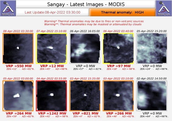
According to MIROVA, the MODIS satellite recorded a very strong thermal anomaly (1242 MW) on April 4 at the start of the first pulse of seismo-acoustic activity, the first since March 18, 2022. This anomaly is likely associated with a flow of lava higher. The thermal anomalies detected by the VIIRS satellite are located on the northern flank of the Sangay, corresponding to the lava flow emitted by the northern vent.
Source : IGEPN
Read the full article: https://www.igepn.edu.ec/servicios/noticias/1928-informe-volcanico-especial-sangay-n-2022-001
Photos : Flytouio, Mirova.
Chile , Hudson :
SISMOLOGY
176 VT type seismic events associated with rock fracturing (Volcano-Tectonic type) were recorded.
The most energetic earthquake presented a value of local magnitude (ML) equal to 2.3, located 6.8 km south-south-east of the volcanic edifice, at a depth of 4.8 km by relative to the crater.
In addition, 119 LP-type seismic events were recorded, associated with fluid dynamics within the volcanic system (Long Period type). The size of the largest earthquake estimated from the reduced displacement parameter (RD) was equal to 15 cm2.
Similarly, 2 seismic events of the TR type were recorded, associated with sustained dynamics over time of the fluids inside the volcanic system (TRemor type). The size of the largest earthquake estimated from the reduced displacement parameter (RD) was equal to 5 cm2.
In addition, 13 HB-type seismic events were recorded, associated with both rock fracturing and fluid dynamics within the volcanic system (HyBrid type). The most energetic earthquake presented a value of Local Magnitude (ML) equal to 2.3 and its Reduced Displacement (RD) was 1102 cm2, (see REAV 20220306 www.sernageomin.cl/volcan-lonquimay) located at 6, 5 km south-southeast of the center of the caldera, with a depth of 5.2 km from the summit.
FLUID GEOCHEMISTRY
No anomalies were reported in the emissions of sulfur dioxide (SO2) into the atmosphere in the area near the volcanic edifice, according to data published by the Tropospheric Monitoring Instrument (TROPOMI) and the Ozone Monitoring Instrument (OMI ) Sulfur Dioxide Group (http://so2.gsfc.nasa.gov/).
SATELLITE THERMAL ANOMALIES
During the period, no thermal alert was recorded in the area associated with the volcanic edifice, according to data processed by the Medium Infrared Observation of Volcanic Activity (MIROVA) (http://www.mirovaweb .it/) and by the analytical processing of Sentinel 2-L2A satellite images, in combination with false color bands.
GEODESY
According to data provided by 2 GNSS stations, no deformation anomalies attributable to changes in the internal dynamics of the volcano were observed during the evaluated period.
SURVEILLANCE CAMERAS
The images provided by the fixed camera installed near the volcano did not record degassing columns on the building or variations related to surface activity.
Activity remained at levels considered low, suggesting stability of the volcanic system.
The volcanic technical alert is maintained at:
GREEN TECHNICAL ALERT: Active volcano with stable behavior – There is no immediate risk.
Source : Sernageomin
Photo : Norm Banks, 1991 (U.S. Geological Survey).
Kamchatka , Sheveluch :
56.64 N, 161.32 E;
Elevation 3283 m (10768 ft), the dome elevation ~2500 m (8200 ft)
Aviation Colour Code is ORANGE
The extrusive eruption of the volcano continues. Ash explosions up to 10-15 km (32,800-49,200 ft) a.s.l. could occur at any time. Ongoing activity could affect international and low-flying aircraft.
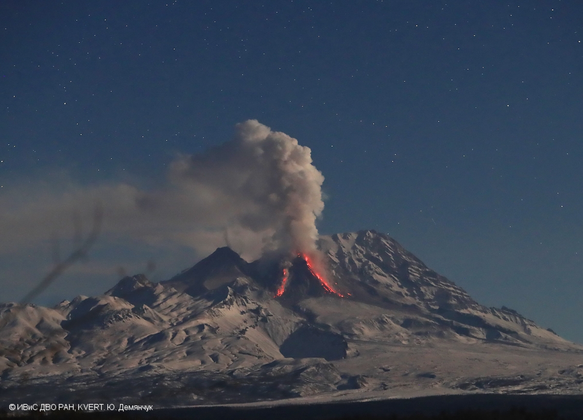
A growth of the lava dome continues, a strong fumarolic activity, and an incandescence of the lava dome, and hot avalanches accompanies this process. Satellite data by KVERT showed: on 09, and 13-14 April, explosions sent ash up to 12, and 6 km a.s.l., respectively. On 09-10 April, the ash cloud moved more than 2000 km to the northeast of the volcano; on 13 and 14 April, ash clouds moved 80 km southwest and south, and 110 km southeast of the volcano, respectively; a thermal anomaly over the volcano all week.
Source : Kvert.
Photo : Yu. Demyanchuk. IVS FEB RAS, KVERT ( archive).
Indonesia , Anak Krakatau :
VOLCANO OBSERVATORY NOTICE FOR AVIATION – VONA
Issued : April 15 , 2022
Volcano : Anak Krakatau (262000)
Current Aviation Colour Code : ORANGE
Previous Aviation Colour Code : orange
Source : Anak Krakatau Volcano Observatory
Notice Number : 2022KRA28
Volcano Location : S 06 deg 06 min 07 sec E 105 deg 25 min 23 sec
Area : Lampung, Indonesia
Summit Elevation : 502 FT (157 M)
Volcanic Activity Summary :
Eruption with ash clouds at 03:34 UTC (10:34 local time). The eruption lasted for 153 seconds.
Volcanic Cloud Height :
Best estimate of ash-cloud top is around 2742 FT (857 M) above sea level, may be higher than what can be observed clearly. Source of height data: ground observer.
Other Volcanic Cloud Information :
Visuals directly from the cctv were observed eruptions with the color of the thick white-grey eruption smoke 700m from the top of the volcano, the wind direction slowly to the southwest.
Remarks :
Eruption recorded on seismogram with maximum amplitude 40 mm and maximum duration 153 second.
Source : Magma Indonésie .
Photo : Jára Pokorný.
Hawaii , Kilauea :
19°25’16 » N 155°17’13 » W,
Summit Elevation 4091 ft (1247 m)
Current Volcano Alert Level: WATCH
Current Aviation Color Code: ORANGE
Activity Summary:
The summit eruption of Kīlauea Volcano, within Halemaʻumaʻu crater, continued over the past 24 hours. All recent activity has been confined to the crater. Everything is status quo for summit and East Rift Zone. No threats are apparent.

Halemaʻumaʻu crater Lava Lake Observations:
Eruption of lava from the western vent into the active lava lake and onto the crater floor continued over the past 24 hours. The active part of the lava lake showed continuous surface activity, with an occasional flow overtopping the perched levees. The western end of the lake has risen 1 m (3 feet) since April 10. The surface flow from the west vent remains active, and has covered areas along the southwest and western margins. Activity continues along the eastern lake margin. Since the beginning of this eruption on September 29, 2021, the crater floor has seen a total rise of about 99 meters (325 feet). The volume of lava effused since the beginning of this eruption was approximately 66 million cubic meters (18 billion gallons) as measured on April 6, 2022.
Summit Observations:
Summit tiltmeters has shown a flat trend over the past 24 hours. Volcanic tremor remains above background levels. A sulfur dioxide (SO2) emission rate of approximately 2,800 tonnes per day (t/d) was measured on April 13, 2022.
Source : HVO.
Photo : Bruce Omori / Paradise Helicopters.
Canary Islands / Azores , Cumbre Vieja / San Jorge :
Canary Islands:
Post-eruptive activity Cumbre Vieja, La Palma, April 13, 2022, 09:00 UTC
In the last 7 days, since the last release (April 5 at 9:00 UTC), 29 earthquakes have been located on the island of La Palma. The magnitudes are between 0.8 and 1.9 (mbLg). None of the earthquakes of this period were felt by the population. The location of hypocenters continues below the central area of Cumbre Vieja, in the same areas as in previous weeks, at depths between 0 and 14 km. No earthquakes were located at greater depths.
The island’s network of permanent GNSS stations shows no significant deformation that could be associated with volcanic activity.
Azores:
The seismicity has decreased a little but the alert level remains at 4. So far, about 244 earthquakes felt by the population have been recorded. From 10:00 a.m. to 10:00 p.m. on April 14, no earthquakes were felt.

Sources : IGNes , Civisa.
Photos : ERCC.