December 09 2021.
Italy , Stromboli :
WEEKLY NEWSLETTER, from November 29, 2021 to December 05, 2021 (issue date December 07, 2021)
SUMMARY OF ACTIVITY STATUS
In view of the monitoring data, it is highlighted:
1) VOLCANOLOGICAL OBSERVATIONS: During this period a normal explosive activity of strombolian type was observed with a weak activity of splashes. The total hourly frequency of explosions fluctuated between medium and medium-high values (10-17 events / h). The intensity of the explosions varied from low to high in the North crater area and from low to medium in the Center-South crater area.
2) SEISMOLOGY: The seismological parameters monitored do not show significant variations.
3) SOIL DEFORMATION: The island’s soil deformation monitoring networks have shown no significant changes over the past week
4) GEOCHEMISTRY: The flow of SO2 at an average level
The CO2 flux values recorded at Pizzo Sopra La Fossa are at high levels.
The value of the isotopic ratio of Helium dissolved in the thermal aquifer of Stromboli has further increased compared to the previous sampling in October.
The ratios are at high values.
The updated C / S ratio values were at medium-high levels (C / S = 7.61).
5) SATELLITE OBSERVATIONS: After the effusive event of November 26, the thermal activity observed by satellite showed low level anomalies.
VOLCANOLOGICAL REMARKS
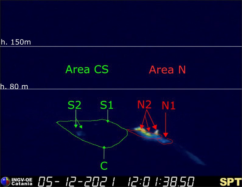
During the observation period, the eruptive activity of Stromboli was characterized by the analysis of the images recorded by the surveillance cameras of the INGV-OE (altitude 190m, Punta Corvi, altitude 400m and Pizzo). The explosive activity was mainly produced by 4 (four) eruptive chimneys located in the North crater area and 4 (four) eruptive chimneys located in the Center-South crater area. All the vents are located inside the depression which occupies the terrace of the crater.
Due to unfavorable weather conditions on December 3 and 4, 2021, the visibility of the crater terrace was insufficient for a correct description of the eruptive activity.
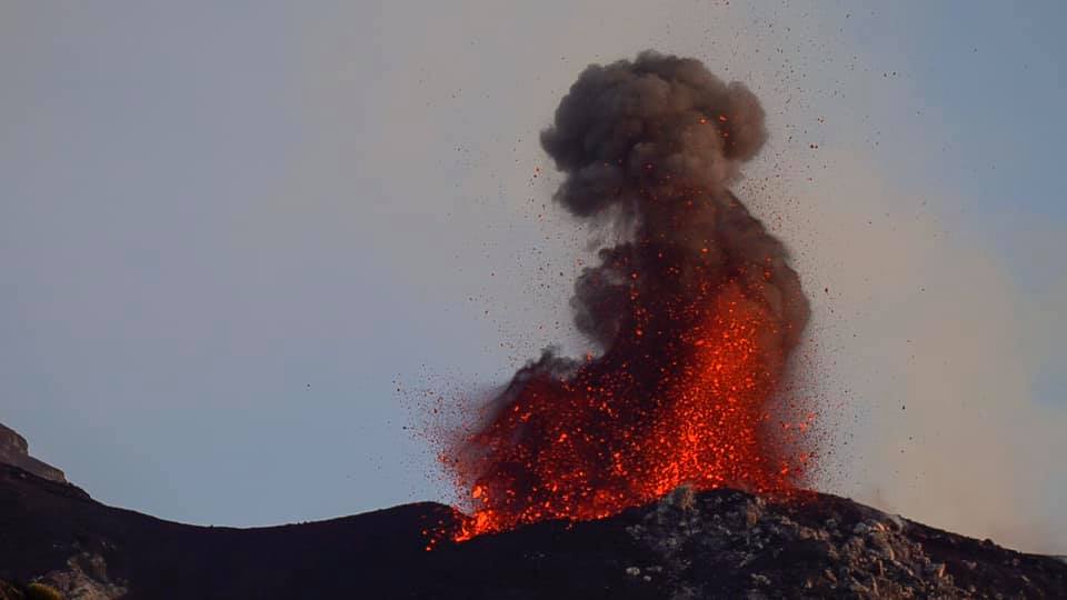
Sector N1, located in the area of the North crater, produced explosions of mainly medium-low intensity (sometimes the products of the explosions exceeded 80 m in height) emitting coarse materials (lapilli and bombs). Sector N2, with three emission points, showed explosive activity of varying intensity, from low (less than 80 m in height) to high (the products exceeded 150 m in height) emitting coarse materials with activity weak and occasional projection. The average frequency of explosions varied from 6 to 12 events / h.
In the Center-South zone, sectors S1 and C did not show significant explosive activity, while the two vents located in sector S2 produced explosions, even simultaneously, of medium-low intensity (sometimes the explosive products exceeded 80 m in height) emitting coarse materials. The frequency of the explosions varied from 4 to 5 events / h.
Source : INGV.
Photos : INGV , Archive web cam.
Spain / La Palma , Cumbre Vieja :
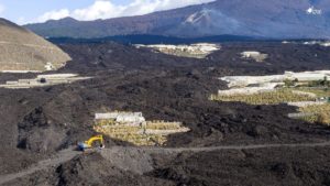
08 December 2021, 09:00 UTC. Eruptive activity continues on La Palma.
Since the last declaration, a total of 29 earthquakes have been located on the island of La Palma, two of which were felt by the population.
The maximum recorded magnitude is 4.0 (mbLg), corresponding to yesterday’s earthquake at 13:29 UTC, 14 km deep and felt with intensity IV (EMS98).
Seismicity continues below the central area of Cumbre Vieja in the same areas as the previous days, most of the earthquakes (20) are located at depths between 9 and 22 km, the rest (9) were located at depths between 30 and 40 km. No earthquake was located at depths less than 9 km.
The amplitude of the tremor signal remains at low levels and is just as stable as the previous days.

As in previous days, the island’s network of permanent GNSS stations does not show a clear trend in the deformation of the stations closest to the eruptive centers.
In the rest of the stations, the slight deflation possibly linked to the deep seismicity has stabilized, except in LP01 which continues to record it.
Based on the image calibrated at 08:45 UTC, a column height of 3,700 m is estimated. with a South-South-East direction.
Yesterday at 2:20 p.m. UTC, due to the significant increase in the height of the eruptive column, the IGN issued a new VONA (Volcano Observatory Notice for Aviation) message indicating that the maximum height of the said column was 4000 m over the sea level.
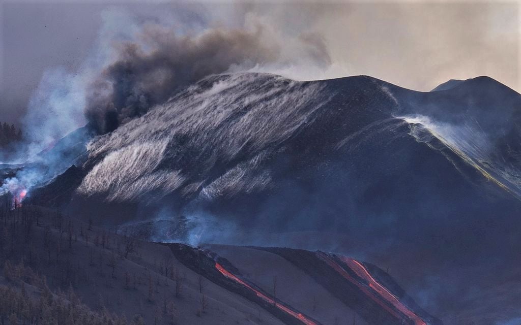
On 3 December a new fissure opened on the SE of the main cone and produced Strombolian activity and fast-moving lava flows that traveled SW, along flow 10. The flow continued to advance W on 4 December, though at a slower rate as it moved over new ground in gaps between flows 3 and 11. Several new vents along an E-W fissure located W of Montaña del Cogote opened at noon on 4 December and produced multiple fast-moving lava flows. The flows descended SW over new ground, crossing into the municipalities of Tazacorte and Los Llanos de Aridane, destroying 60 homes. The flow joined flow 9, reached the sea cliff in the Las Hoyas area by 5 December, and descended the cliff the next day. During 6-7 December lava advanced W through multiple tubes and fed flows 1 and 2, and the S delta. The NE vent was quiet for a few days, but sporadic Strombolian activity and ash emissions had returned. Cracks and fractures in the upper part of the cone were visible. Several vents in the central and SE parts of the main cone also produced sporadic Strombolian activity and ash emissions.
Sources : IGN es , GVP .
Photos : I love the world , Volcanes y Ciencia Hoy .
Vanuatu Archipelago , Ambae :
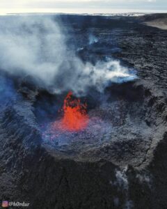
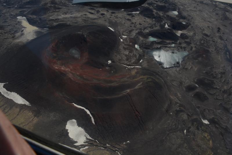
The Vanuatu Meteorology and Geo-Hazards Department (VMGD) reported that steam emissions were visible rising an average of 250 m from Ambae’s Lake Voui during 5-7 December. A still image of video taken from an airplane showed brown water surrounding an active and growing cone that was ejecting wet tephra less than 10 m above the lake’s surface. The Alert Level remained at 1 (on a scale of 0-5) and the public was warned to stay outside of the Danger Zone defined as a 2-km radius around the 2017-2018 active vents in Lake Voui and away from drainages during heavy rains.
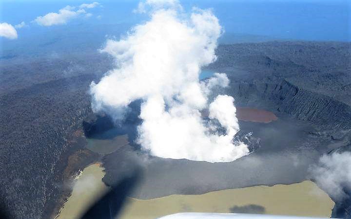
The island of Ambae, also known as Aoba, is a massive 2,500 km3 basaltic shield that is the most voluminous volcano of the New Hebrides archipelago. A pronounced NE-SW-trending rift zone dotted with scoria cones gives the 16 x 38 km island an elongated form. A broad pyroclastic cone containing three crater lakes (Manaro Ngoru, Voui, and Manaro Lakua) is located at the summit within the youngest of at least two nested calderas, the largest of which is 6 km in diameter. That large central edifice is also called Manaro Voui or Lombenben volcano. Post-caldera explosive eruptions formed the summit craters about 360 years ago. A tuff cone was constructed within Lake Voui (or Vui) about 60 years later. The latest known flank eruption, about 300 years ago, destroyed the population of the Nduindui area near the western coast.
Source : GVP
Photo : archive 2018 , geohazard.
Alaska , Omok :
53°23’49 » N 168°9’58 » W,
Summit Elevation 3520 ft (1073 m)
Current Volcano Alert Level: NORMAL
Current Aviation Color Code: GREEN
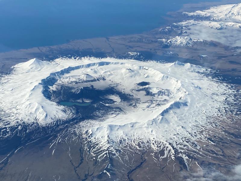
Between September and November 2021, the Alaska Volcano Observatory observed a change from the long-term deformation pattern at Okmok volcano as measured by two continuous Global Navigation Satellite Systems (GNSS) stations within the caldera. The deformation pattern at Okmok typically consists of near-continuous inflation, with episodes during which this motion accelerates, and is generally thought to be related to magma injection somewhere between 2–4 km (1.2–2.5 miles) below the caldera floor. In contrast, the changes that we observed recently are consistent with a pressure increase at a shallower depth—less than 1 km (0.6 miles) below the caldera floor. The map location of this new deformation source is near Cone D, just south of the young tephra cone Ahmanilix, created during the 2008 eruption. The deformation has since returned to background levels. There have been no notable changes in seismic activity during this time period, and satellite images have shown no surface changes.
The recently observed deformation is consistent with a small intrusion of magma at a shallow depth, but other non-magmatic processes such as hydrothermal activity cannot be ruled out. If the deformation was caused by a shallow magma intrusion, this may increase the likelihood of an eruption. Previous eruptions at Okmok have occurred with little precursory seismic activity, and AVO continues to monitor the volcano closely.
Ground deformation at Okmok is monitored with 4 continuous GNSS instruments, two inside the caldera and two outside. Data for these stations are downloaded remotely and analyzed daily. The volcano has had a local real-time seismic monitoring network since 2003. Currently, the network consists of 7 three-component seismometers on the eastern portion of Umnak Island, including 4 within the caldera. Okmok is also monitored by satellite data, a web camera, and remote infrasound and lightning networks.
Okmok volcano is a 10-kilometer (6-mile) -wide caldera that occupies most of the eastern end of Umnak Island, located 120 kilometers (75 miles) southwest of Unalaska/Dutch Harbor in the eastern Aleutian Islands. Okmok has had several eruptions in historical time typically consisting of lava flows crossing the caldera floor, such as in 1945, 1958, and 1997. However, in 1817, Okmok produced an explosive eruption that resulted in ash fall in the Dutch Harbor area. The volcano last erupted in July–August 2008, producing continuous ash emissions that fluctuated between about 1,500 and 9,000 meters (5,000 and 30,000 feet) above sea level for the 5-week duration of the eruption, with an initial plume height of 15,000 meters (50,000 feet) during the first 12 hours. This eruption resulted in the construction of a new cone (Ahmanilix) within the caldera.
The nearest settlement is Nikolski, about 70 kilometers (45 miles) west of the volcano. A ranch caretaker family lives at Fort Glenn on the flank of the volcano about 10 kilometers (6 miles) east of the caldera rim during the summer months.
Source : AVO.
Photos : Mees, Burke 04/2021 , 06/2020 .
Guatemala , Fuego :
SPECIAL VOLCANOLOGICAL BULLETIN
INCREASE IN STROMBOLIAN ACTIVITY
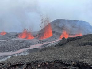
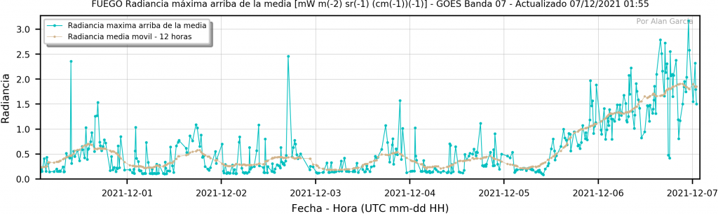
Since December 3, the Fuego volcano has shown a decrease in the number of strong explosions and an increase in the duration of periods of tremor (internal vibration), associated with the rise of magma. The increase in radiance values recorded from the afternoon / night of December 4 is explained by the appearance of a lava flow in the Ceniza ravine, which according to OVFGO reports reached 500 meters in length and generated abundant avalanches in the direction of the canyon in question.
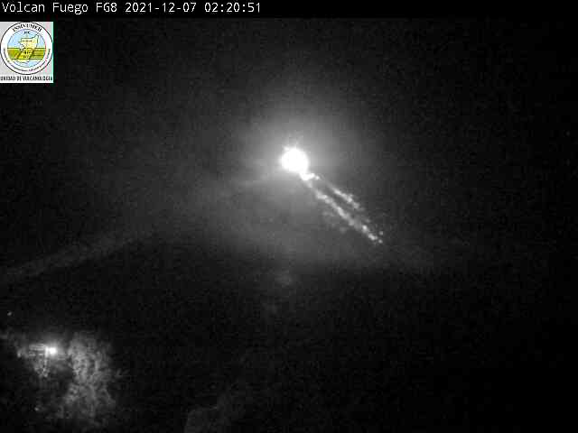
This Strombolian activity continued to increase during the afternoon and night, generating almost continuous explosions, which raise pulses of incandescent material to heights between 200 and 300 meters above the crater. The activity is accompanied by abundant avalanches towards the ravines of Trinidad, Taniluyá, El Jute, Las Lajas and Seca, some reaching the edge of the vegetation. Sometimes the explosions produce dense plumes of ash that rise to an altitude of 4,700 m (15,420 feet) and are scattered to the south and west. Faint and modest sounds are heard, compared to those of a train locomotive, which can be heard for several miles in communities on the South Flank. The network of seismic stations records the activity of explosions and tremors (internal vibration).
Due to the increase in this strombolian activity, it is not excluded that a rash may occur in the next few hours, so appropriate precautions should be taken.
INSIVUMEH maintains visual and instrumental monitoring of this activity through OVFGO observers, webcams, seismic and infrasound stations.
Source : Insivumeh.