November 25 , 2021.
Italy , Stromboli :
Weekly bulletin from November 15, 2021 to November 21, 2021 (issue date November 23, 2021)
SUMMARY OF ACTIVITY STATUS
In view of the monitoring data, it is highlighted:
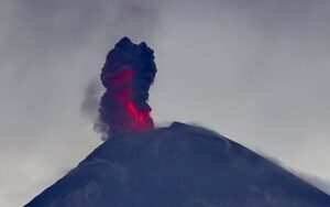
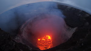
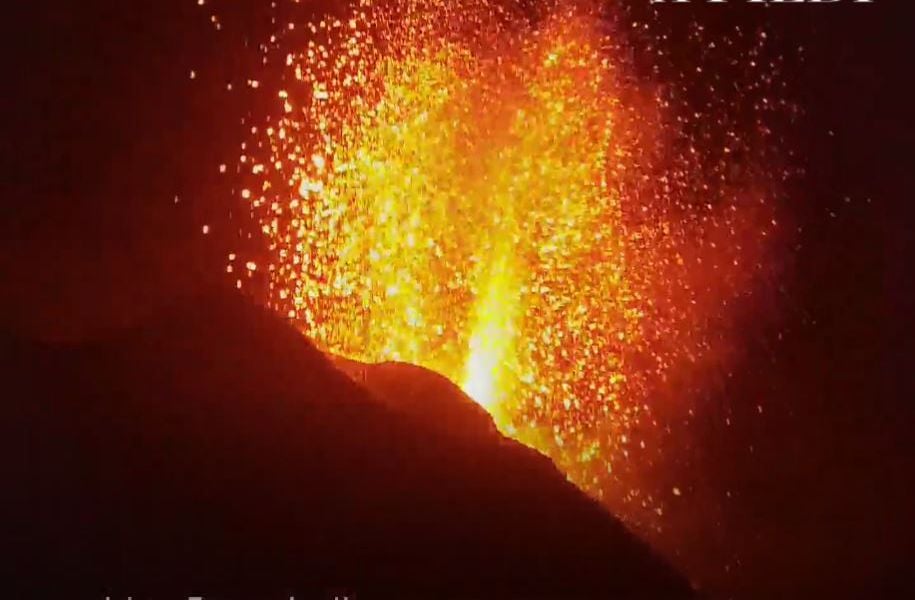
1) VOLCANOLOGICAL OBSERVATIONS: During this period, a normal explosive activity of Strombolian type was observed with a splash activity culminating in a modest rheomorphic flow coming from the North zone. The total hourly frequency of explosions fluctuated between medium and high values (14-25 events / h). The intensity of the explosions varied from low to high in the North crater area and from low to medium in the Center-South crater area.
2) SEISMOLOGY: The seismological parameters monitored do not show significant variations.
3) DEFORMATIONS: The island’s soil deformation monitoring networks have shown no significant changes over the past week.
4) GEOCHEMISTRY: The flow of SO2 at an average level
The values of the CO2 flows recorded on the Pizzo Sopra La Fossa are at high levels.
There are no updated values of the C / S ratio.
The value of the isotopic ratio of Helium dissolved in the thermal aquifer of Stromboli shows a further increase compared to the previous sampling. The ratios are at high values.
5) SATELLITE OBSERVATIONS: The thermal activity in the summit area is at a low level.
VOLCANOLOGICAL OBSERVATIONS
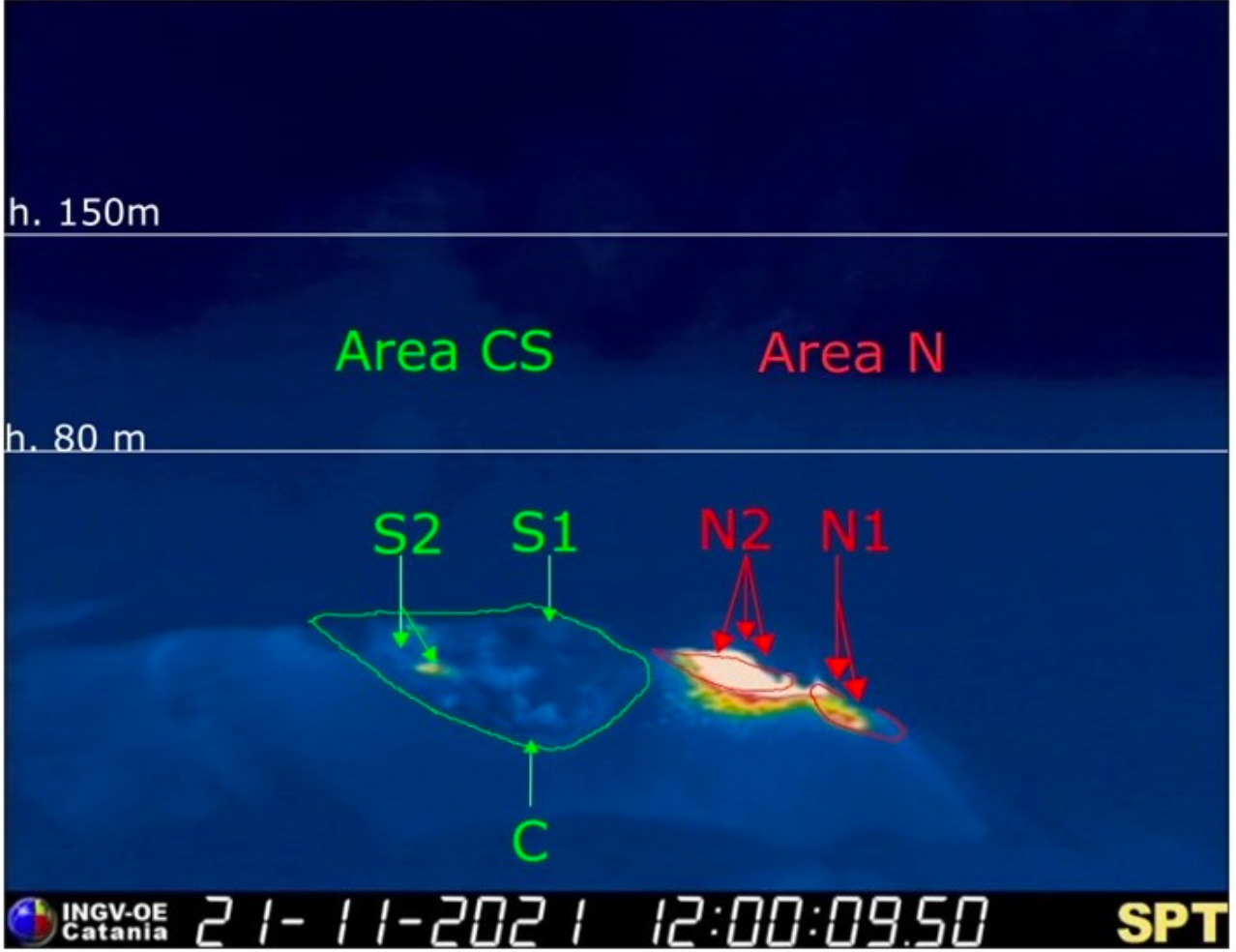
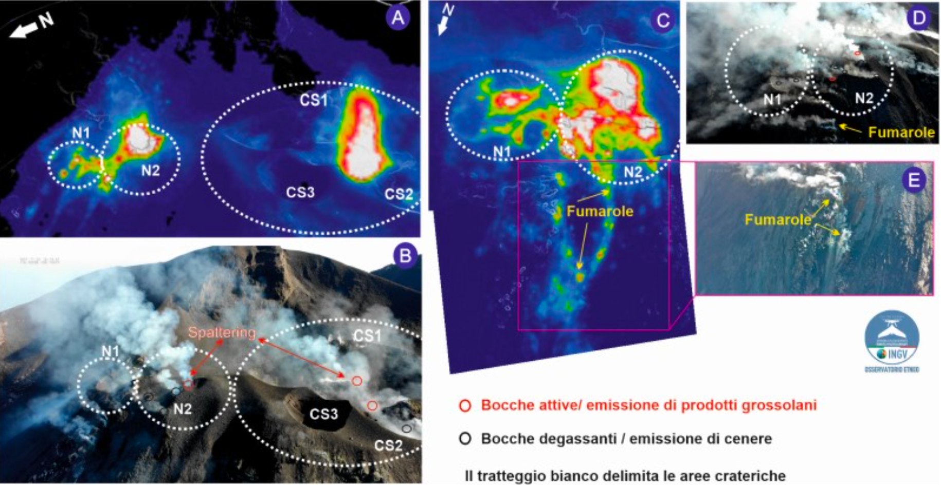
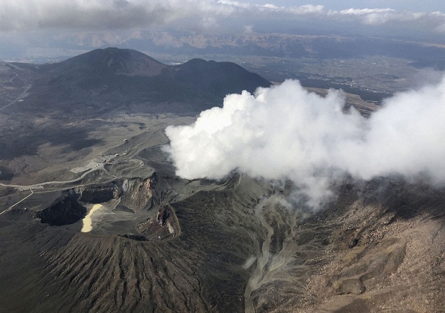
During the observation period, the eruptive activity of Stromboli was characterized by the analysis of the images recorded by the surveillance cameras of the INGV-OE (altitude 190m, Punta Corvi, altitude 400m and Pizzo) and by observations made by INGV staff. The explosive activity was mainly produced by 5 (five) eruptive chimneys located in the area of the North crater (Zone N) and by 4 (four) eruptive chimneys located in the area of the Center-South crater (Zone CS).
All the vents are placed inside the depression which occupies the terrace of the crater.
On November 21, a modest rheomorphic flow from the accumulation of products of intense splash activity in the northern area of the crater terrace was observed.
Observations of surveillance cameras
Sector N1, with two emission points, located in the area of the North crater produced explosions of mainly medium-low intensity (sometimes the products of the explosions exceeded 80 m in height) emitting coarse materials (lapilli and bombs) . Sector N2, with three emission points, exhibited explosive activity of varying intensity, from low (less than 80 m high) to high (products exceeded 150 m in height) emitting coarse materials with activity of splashing with intense pulses. The average frequency of explosions varied from 9 to 17 events / h.
In the Center-South zone, sectors S1 and C did not show significant explosive activity, while the two vents located in sector S2 produced explosions, even simultaneously, of medium-low intensity (sometimes the explosive products exceeded 80 m in height) emitting coarse matter. The frequency of the explosions varied from 4 to 9 events / h.
Field observations by drones
As part of the activities carried out within the framework of the INGV-DPC Annex A convention and the UN departmental project, an inspection was carried out with drones at an altitude of 400 m on November 20. 285 RGB and thermal images were acquired thanks to which it was possible to observe the explosive activity both in the area of the Center-South crater and in the area of the North crater, or even simultaneously. At least 2 degassing outlets with low ash emissions in sector N1 have been identified, at least 6 outlets, one of which is characterized by spraying activities in sector N2.
As for the area of the CS crater, 2 vents emitted fragments of lava and one degassed. It should also be noted the presence of numerous fumaroles in the upper part of the Sciara del fuoco, aligned in the North-North-West direction downstream of the area of the North crater, with a length of about 60 m and two fumaroles at the North-North-West of CS3.
Source : INGV.
Photos : webcam via Alicja Szojer , INGV.
Spain / La Palma , Cumbre Vieja :
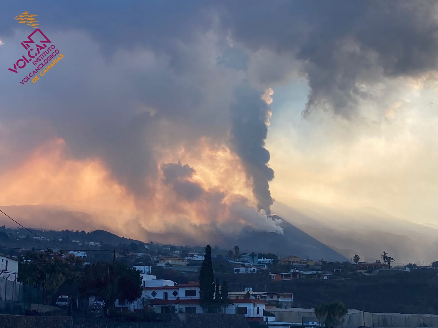
November 24, 2021 09:00 UTC. Eruptive activity continues on La Palma.
Since the last declaration, a total of 72 earthquakes have been located in relation to the volcanic reactivation of the Cumbre Vieja region, of which 5 were felt by the population.
The maximum recorded magnitude is 3.8 (mbLg) corresponding to today’s earthquake at 4:44 UTC, with a depth of 35 km.
During the period considered, 48 earthquakes were located at a depth of about 30 km, the rest of the hypocenters of the period are located at a shallower depth, about 12 km.
The amplitude of the volcanic tremor signal continues at lower average levels.
The island’s network of permanent GNSS stations shows a slight deformation to the south at station LP03, which is closest to the eruptive centers.
In the rest of the stations, the slight deflation possibly linked to the deep seismicity has stabilized, except in LP01 which continues to record it.
In view of the image calibrated at 08:45 UTC, a column height of 4300 m is estimated, with a cloud diffusing in the easterly direction.
The new lava delta located in the North, occupies an area of five hectares and reaches a maximum distance from the cliff of 350 meters. There are several overflows in the lava channels and an increase in the number of active channels, but without occupying new land.

The cloud of ash and sulfur dioxide should remain oriented east-northeast of the eruptive focus. This is an unfavorable scenario for aeronautical operations, mainly for La Palma airport.
Seismicity at intermediate depths remains at low levels and continues to be located in the same areas. At depths greater than 20 kilometers, the seismicity remains at an intense level with a slight decrease compared to yesterday. The maximum recorded magnitude was 3.8 mbLg, for an event recorded this Wednesday, at 4:44 a.m. at a depth of 35 kilometers.
Source : IGN es , El Pais .
Photos : Involcan , PAU DE LA CALLE (El Pais)
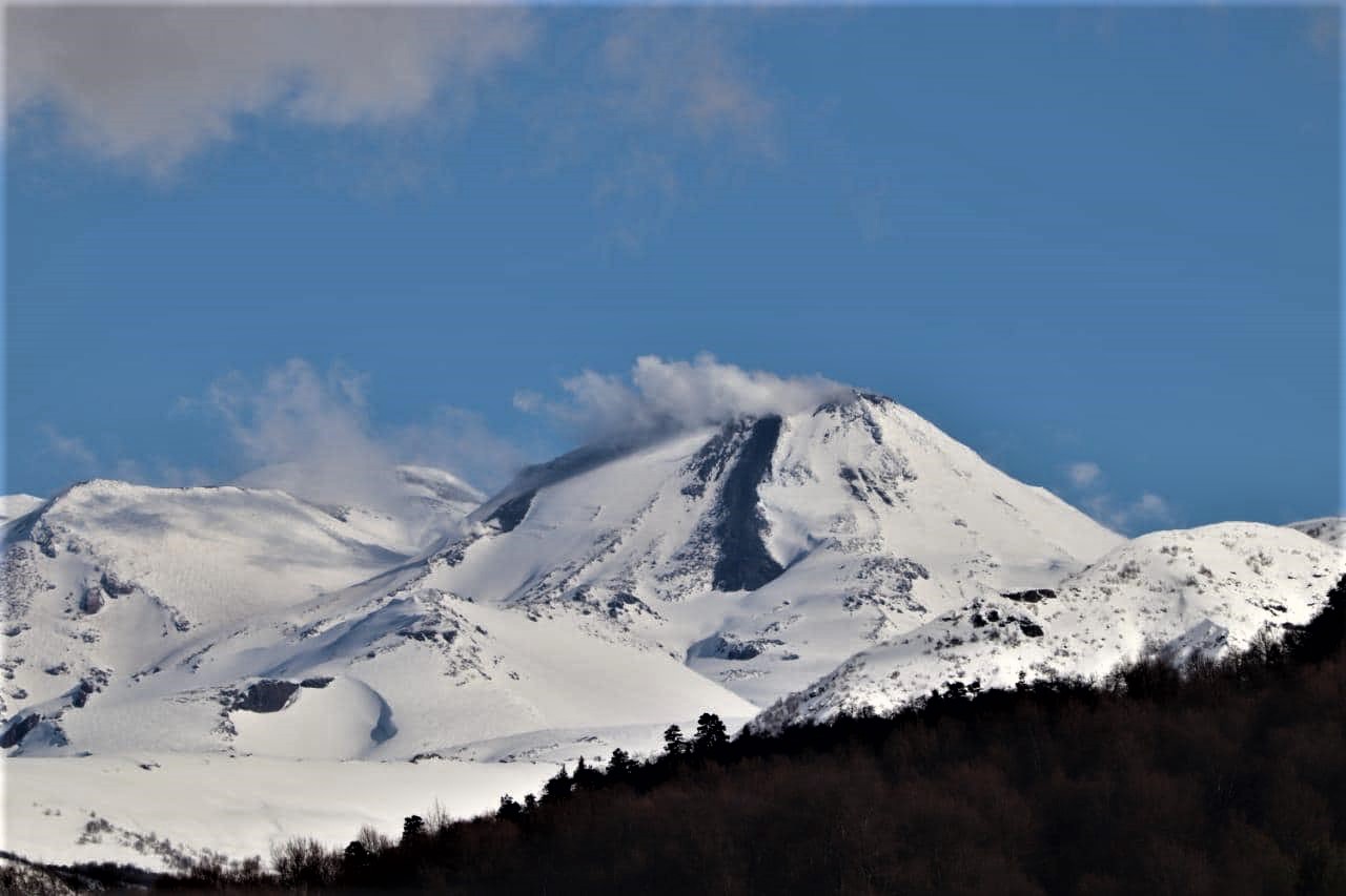
Chile , Nevados de Chillan :
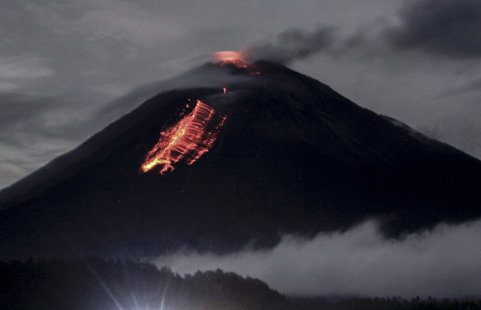
SERNAGEOMIN reported continuing explosive and effusive activity at Nevados de Chillán’s Nicanor Crater during 1-15 November. Explosions generated both plumes with moderate ash content and white steam-rich plumes that rose as high as 2 km above the crater rim. Explosions occasionally ejected incandescent material onto the N side of the crater and the N flank.
A new dome, which had emerged around 28 October at the L7 vent, was partially destroyed by explosions on 8 November, and then regrew to 80 m long and 55 m wide. Pyroclastic flows descended the NE flank, traveling as far as 700 m on 8 and 10 November. The L7 lava flow, between the inactive L5 and L6 flows, slowly advanced and was 930 m long; a NE branch of L7 had not advanced since 14 October, though SE and E branches formed on 9 and 14 November, respectively. A second active flow, L8, had not lengthened past 385 m. Sulfur dioxide emissions averaged 300 tons per day, peaking at 462 tons per day on 14 November, and were lower than rates recorded during the last half of September. The Alert Level remained at Yellow, the second lowest level on a four-color scale. ONEMI stated that Alert Level Yellow (the middle level on a three-color scale) remained in place for the communities of Pinto and Coihueco, noting that the public should stay at least 2 km away from the crater.
Special Report on Volcanic Activity (REAV), Ñuble region, Nevados de Chillán volcanic complex, November 24, 2021, 6:10 a.m. local time (Continental Chile).
The National Service of Geology and Mines of Chile (Sernageomin) publishes the following PRELIMINARY information, obtained thanks to the monitoring equipment of the National Volcanic Monitoring Network (RNVV), processed and analyzed at the Volcanological Observatory of the Southern Andes ( Ovdas):
On Wednesday 23 November 2021, at 05:42 local time (08:42 UTC), the monitoring stations installed near the volcanic complex of Nevados de Chillán recorded an earthquake associated with the fracturing of rocks (volcano-tectonic type VT) in the volcanic system. .
The characteristics of earthquakes after their analysis are as follows:
TIME OF ORIGIN: 05:42 local time (08:42 UTC)
LATITUDE: 36.887 ° S
LONGITUDE: 71.336 ° W
DEPTH: 4.3 km
LOCAL MAGNITUDE: 3.0 (Ml)
OBSERVATIONS:
No superficial activity was observed associated with this event.
The volcanic technical alert remains at the Yellow level.
Sources : GVP , Sernageomin.
Photo : REAV Servicio Nacional de Geología y Minería.
Japan , Asosan :
JMA lowered the Alert Level for Asosan to 2 (on a scale of 1-5) at 1100 on 18 November and decreased the restricted area to a radius of 1 km, noting that no eruptions had been recorded since the 21 October eruption. The sulfur dioxide emission rate remained elevated in November and was 2,100 tons per day on 16 November. The amplitudes of volcanic microtremors fluctuated for a period after the eruption, though they were generally small beginning on 1 November.
The 24-km-wide Asosan caldera was formed during four major explosive eruptions from 300,000 to 90,000 years ago. These produced voluminous pyroclastic flows that covered much of Kyushu. The last of these, the Aso-4 eruption, produced more than 600 km3 of airfall tephra and pyroclastic-flow deposits. A group of 17 central cones was constructed in the middle of the caldera, one of which, Nakadake, is one of Japan’s most active volcanoes. It was the location of Japan’s first documented historical eruption in 553 CE. The Nakadake complex has remained active throughout the Holocene. Several other cones have been active during the Holocene, including the Kometsuka scoria cone as recently as about 210 CE. Historical eruptions have largely consisted of basaltic to basaltic-andesite ash emission with periodic strombolian and phreatomagmatic activity. The summit crater of Nakadake is accessible by toll road and cable car, and is one of Kyushu’s most popular tourist destinations.
Source : GVP.
Photo : Kyodonews.
Indonesia , Semeru :
PVMBG reported that gray-and-white emissions rose 200-700 m above Semeru’s summit and drifted SW, N, and E during 16-23 November. The emissions were visible almost daily; weather clouds occasionally prevented visual observations of the summit. The Alert Level remained at 2 (on a scale of 1-4), with a general exclusion zone of 1 km and extensions to 5 km in the SSE sector.
VOLCANO OBSERVATORY NOTICE FOR AVIATION – VONA.
Issued : November 24 , 2021
Volcano : Semeru (263300)
Current Aviation Colour Code : ORANGE
Previous Aviation Colour Code : orange
Source : Semeru Volcano Observatory
Notice Number : 2021SMR72
Volcano Location : S 08 deg 06 min 29 sec E 112 deg 55 min 12 sec
Area : East java, Indonesia
Summit Elevation : 11763 FT (3676 M)
Volcanic Activity Summary :
Eruption with volcanic ash cloud at 23h27 UTC (05h27 local). Eruption and ash emission is continuing.
Volcanic Cloud Height :
Best estimate of ash-cloud top is around 14003 FT (4376 M) above sea level, may be higher than what can be observed clearly. Source of height data: ground observer.
Other Volcanic Cloud Information :
Ash-cloud moving to west and south west
Sources : GVP , Magma Indonésie .
Photo : Umarul Faruq .
Iceland , Grímsvötn :
Measurements in Grímsvötn show that the ice-cap has started subsiding. This could be an indication that a Jökulhlaup is impending. A scientific meeting about the situation will be held today with Civil protection.
Examples are that volcanic eruption can occur in Grímsvötn after water is drained from there. It is believed that volcanic eruptions can occur after sudden pressure release due to reduced water level in the lake. The last time something similar happened was in 2004, 1934 and 1922.
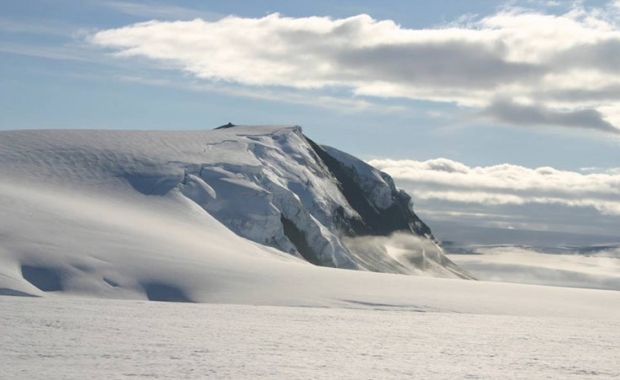
Glacier flood starting from Grímsfjall volcano
It was announced today (24-November-2021) that Grímsvötn lake in Grímsfjall volcano is about to start. It is going to take the glacier flood few hours to days to get to the glacier rivers that flow south of Vatnajökull glacier.
This also risks an eruption starting in Grímsfjall volcano. If that actually happens remains to be seen. Last glacier flood in Grímsvötn lake was in 2018, but that did not result in a eruption.
Sources : Vedur is , icelandgeology.net .
Photo : ICE-SAR