January 14 , 2020.
Ecuador / Galapagos , Fernandina :
Special report of the Fernandina volcano N ° 2 – 2020
Update of eruptive activity.
Summary :
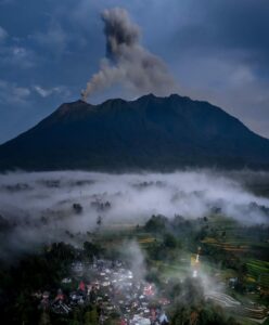
On January 12, 2020, shortly before 6:10 p.m. local time in the Galapagos (TG = UTC – 6 hours or Equatorial time – 1 hour), the Fernandina volcano began its third eruption in less than 3 years. This eruption was preceded by an increase in seismic activity (Special Report No. 1). Regarding this situation, the Directorate of Galapagos National Park (DPNG) was notified, alerting them that an eruption could occur as it had happened on previous occasions. The eruption started shortly before 6.10 p.m. from a circumferential crack located under the eastern edge of the caldera to an altitude of about 1300-1400 m above sea level, causing the emission of lava flows on the eastern flank. A cloud of volcanic gas was also observed at an approximate height of 1500-2000 m above the level of the crack (~ 3-3.5 km above sea level) and moving towards the West -North West. The eruption was observed by the park wardens of the Galapagos National Park from the Bolivar Canal station. In the past few hours, the level of seismic activity, the emission of volcanic gas and thermal anomalies have decreased significantly, indicating a rapid decrease in eruptive activity, similar to what happened in 2017 and 2018. It is important to indicate that on other occasions (Fernandina 2009, Wolf 2015, Sierra Negra 2018), an initial drop in initial activity was followed by a second eruptive phase. IG-EPN is continuing volcanic monitoring and will inform if there are changes in the internal or external activity of the volcano.
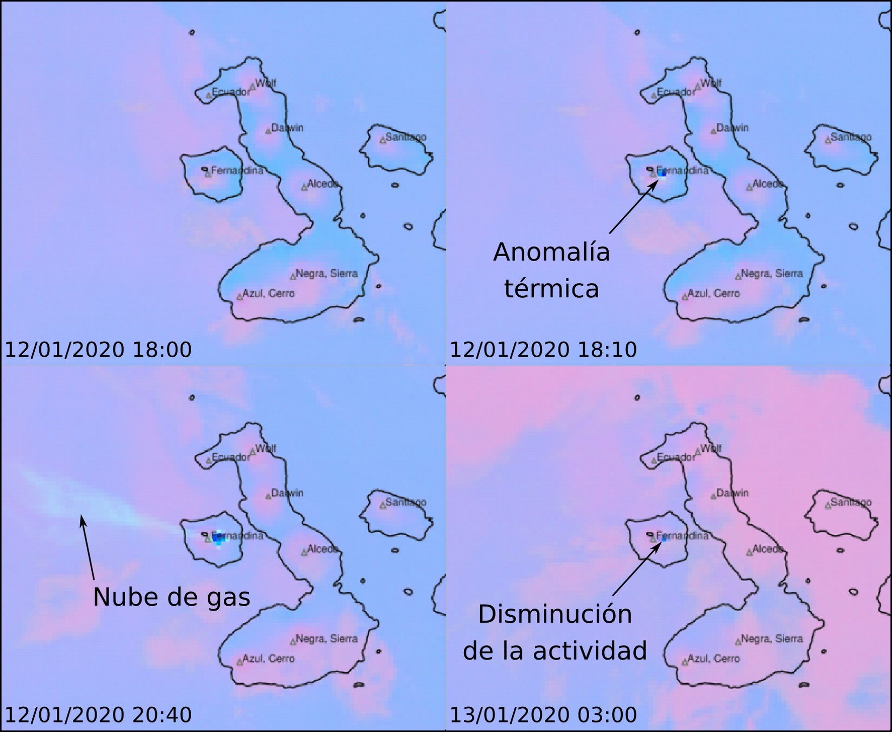
Figure 1. False color satellite images of the Galapagos Islands showing the eruption of the Fernandina volcano (Source: NOAA / CIMSS). Time in Galapagos (UTC – 6 hours or Ecuador – 1 hour).
History:
Fernandina volcano (0.37 ° S, 91.55 ° W, 1476 m), also called Cerro la Cumbre, is a large shield volcano with a summit caldera (6.5 km NW-SE, 4.8 km NE- SW, 900 m deep) of basalt composition built by Fernandina Island (34 km NW-SE, 30 km NE-SW) at the western end of the Galapagos archipelago (Ecuador). It has the highest frequency of volcanic eruptions in the Galapagos during the historical period with at least 27 to 29 eruptions since 1800 (including the current eruption of 2020). Its previous eruption started on June 16, 2018 and lasted about 2 days.
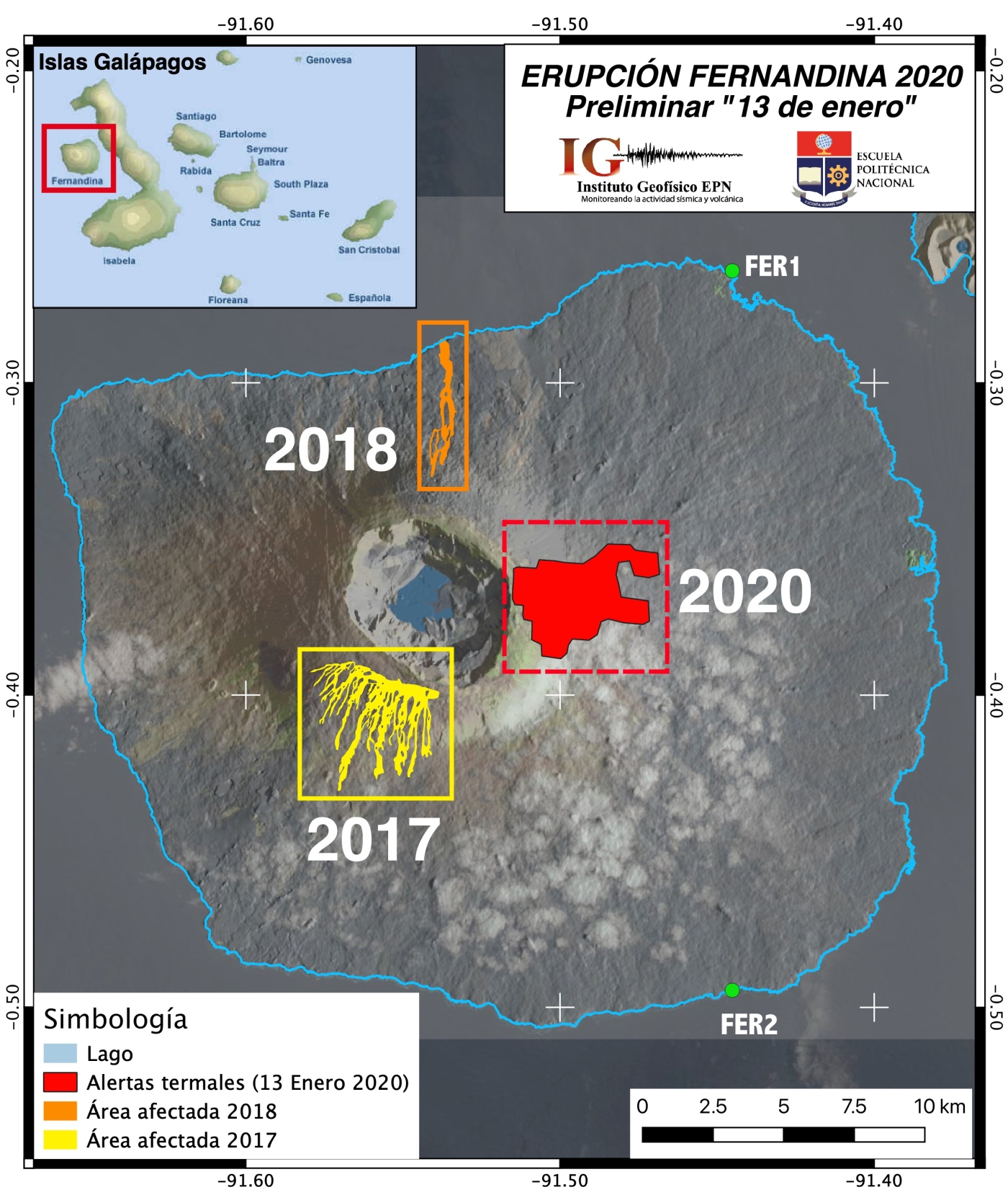
Figure 2. Zones with the presence of thermal alerts detected by FIRMS, for the eruptions of 2017, 2018 and 2020.
Source: NASA (Map prepared by F. Vásconez, IGEPN).
Technical-scientific annex:
Seismicity:
The RMS (indicator which makes it possible to observe the amplitude of the seismic signal) showed a rapid increase following the seismic swarm of January 12, 2020 (Special Report N ° 1), reaching a maximum at 4:50 pm TG, about 70 minutes before from the start of the eruption (Figure 2). Subsequently, a second increase associated with the tremor of the eruption was observed with a peak in amplitude recorded approximately 30 to 40 minutes after the onset of the eruption. From this moment, a gradual decrease in RMS values is observed, almost reaching the pre-eruptive level at the time of publication of this report.
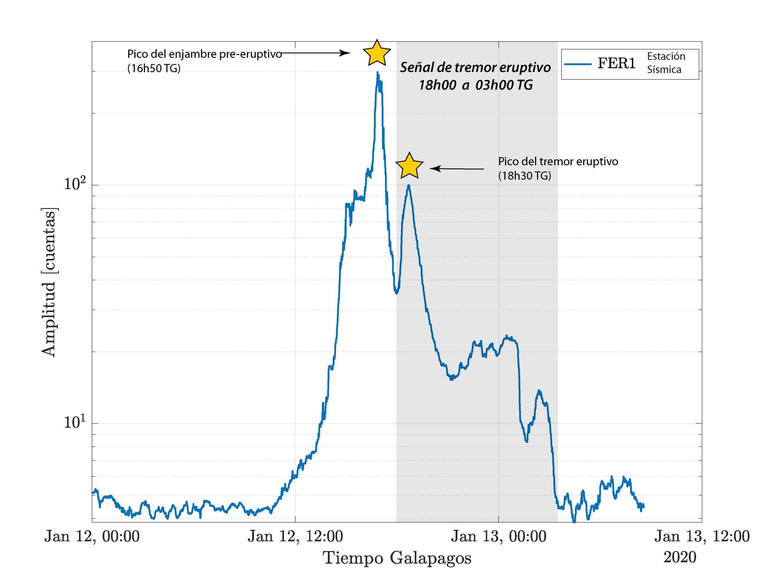
Figure 3. RMS of the seismic signal from the FER-1 station (Source: S. Hernandez, IGEPN).
Thermal anomalies and gas clouds:
On the satellite images provided by NOAA / CIMSS (Figure 1), the appearance of a hot spot corresponding to the start of eruptive activity between 6:00 p.m. and 6:10 p.m. is clearly observed. Immediately after the start of surface activity, we observe the formation of a cloud of volcanic gases oriented West-North-West. Gas emissions decreased after 9:00 p.m. and thermal anomalies gradually decreased until the publication of this report. The Fire Information for Resource Management System (FIRMS) makes it possible to see the extent of the area potentially affected by the eruption on the eastern flank of the Fernandina volcano (Figure 2). So far, lava flows have not reached the coast.
Visual observations:
The eruption was observed and recorded by the forest guards of the Galapagos National Park from the station of the Bolivar Canal
Figure 4. Fernandina Island seen from the Bolivar Canal, where the descent of several lava flows is observed, emitted by a crack located under the edge of the crater of the La Cumbre volcano. (Credits: Galapagos National Park Directorate-PNG).
Recommendations:
It should be noted that there are no human settlements in the area of the eruption and that the direction of the wind brings the gas west-northwest, on the opposite side of the populated islands (Isabela, Santa Cruz, Floreana and San Cristóbal). In the event that lava flows enter the sea, it is recommended to stay away, as explosions and the release of harmful gases may occur when the lava comes into contact with water. In addition, lava flows can cause large fires, as happened during the 2017 eruption.
Source : IGEPN , BB, SH, FJV, SH, PR, FN / Institut géophysique / École nationale polytechnique .
Philippines , Taal :
TAAL VOLCANO BULLETIN 14 January 2020 8:00 A.M.
For the past 24 hours, Taal Volcano’s activity has been characterized by continuous eruption of the Main Crater due to magmatic and hydrovolcanic activity. This ongoing eruption generated 500-meter tall lava fountains topped by dark gray steam-laden plumes reaching approximately 2 kilometers tall that dispersed ash to the southwest and west of the Main Crater. Flashes of volcanic lightning were observed at the base of the degassing plumes this morning. New vents opened up on the northern flank where short 500-meter lava fountains, and within the main crater where steam plumes, have emanated.
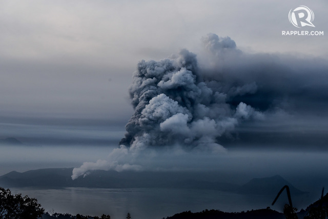
Since the last update, heavy ashfall from the ongoing continuous activity of Taal Volcano has reportedly fallen on the municipalities of Lemery, Talisay, Taal, and Cuenca, Batangas.
The Philippine Seismic Network has recorded a total of two hundred twelve (212) volcanic earthquakes in Taal region as of 2:00 AM, January 14, 2020. Eighty-one (81) of these earthquakes were felt with intensities ranging from Intensity I – V in Tagaytay City, Cavite. Such intense seismic activity probably signifies continuous magmatic intrusion beneath the Taal edifice, which may lead to further eruptive activity.
Sulfur dioxide (SO2) emission was measured at an average of 5299 tonnes/day on 13 January 2020.
Alert Level 4 still remains in effect over Taal Volcano. This means that hazardous explosive eruption is possible within hours to days. DOST-PHIVOLCS strongly reiterates total evacuation of Taal Volcano Island and areas at high risk to pyroclastic density currents and volcanic tsunami within a 14-kilometer radius from Taal Main Crater. Areas in the general north of Taal Volcano are advised to guard against the effects of heavy and prolonged ashfall. Civil aviation authorities must advise aircraft to avoid the airspace around Taal Volcano as airborne ash and ballistic fragments from the eruption column pose hazards to aircraft.

DOST-PHIVOLCS is continually monitoring the eruption and will update all stakeholders of further developments.
ERUPTION UPDATE FOR TAAL VOLCANO ALERT LEVEL 4 (HAZARDOUS ERUPTION IMMINENT) 14 JANUARY 2020 01:00 PM
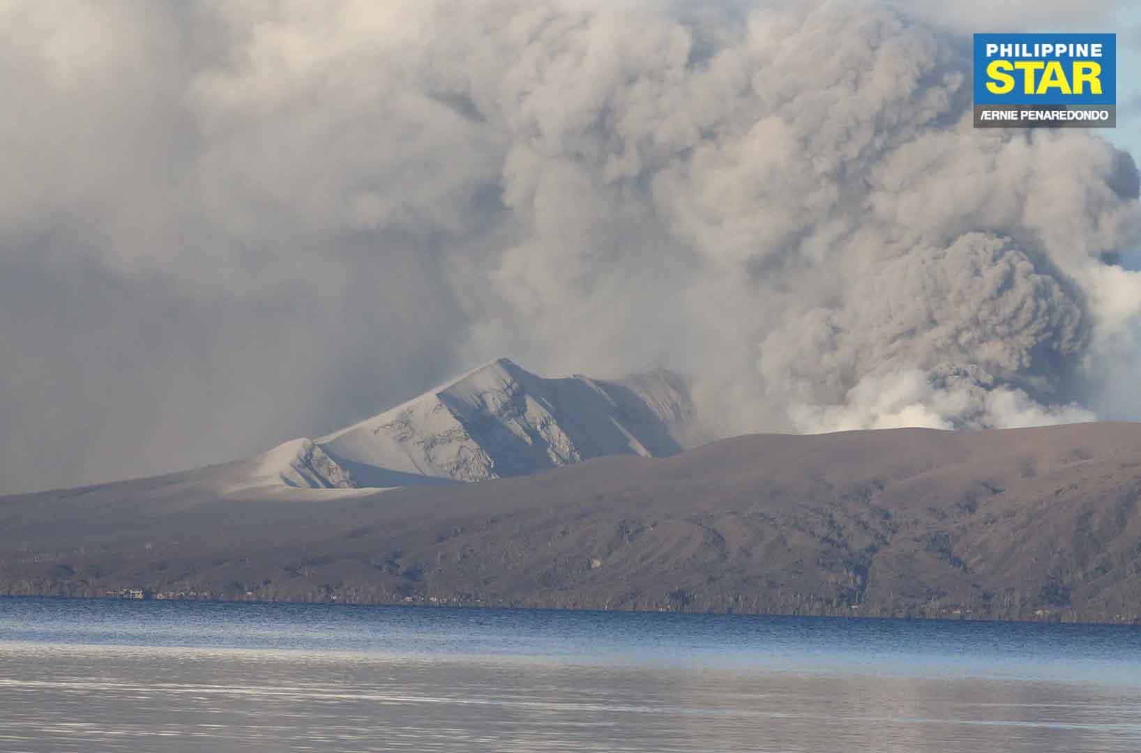
Taal Volcano’s eruption has been characterized by continuous magmatic and hydrovolcanic activity. Lava fountains generated 800-meter tall dark gray steam-laden plumes that drifted to the general southwest.
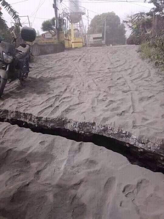
New fissures or cracks were observed in Sinisian, Mahabang Dahilig, Dayapan, Palanas, Sangalang, Poblacion, Lemery; Pansipit, Agoncillo; Poblacion 1, Poblacion 2, Poblacion 3, Poblacion 5, Talisay and Poblacion, San Nicolas. A fissure was also documented across the road connecting Agoncillo to Laurel, Batangas.
The Philippine Seismic Network recorded a total of forty-nine (49) volcanic earthquakes in the Taal region from 2:00 AM to 10:00 AM today. Seven (7) of these earthquakes were felt with intensities ranging from Intensity II to IV in Tagaytay City. The intense seismic activity coupled with fissuring on the caldera region likely signifies continuous magma intrusion beneath the Taal edifice, which may lead to further eruptive activity.
Source : Phivolcs .
Photos : Alecs Ongcal/Rappler , Yobz Apolinario Olmedo , Philippine Weather System/Earthquake Update .
Peru , Sabancaya :
Analysis period: January 6-12, 2020. Arequipa, January 13, 2020.
Alert level: ORANGE
The Peruvian Geophysical Institute (IGP) reports that the eruptive activity of the Sabancaya volcano has been maintained at moderate levels; that is, with the continuous recording of moderate explosions and resulting ash emissions. Consequently, for the following days, no significant change in activity is expected.
During the period from January 6 to 12, 2020, the IGP recorded and analyzed the occurrence of approximately 1,034 earthquakes of volcanic origin, the highest percentage of which is associated with the circulation of fluids (magma, gas , etc.) inside the volcano. During this period, there were on average 8 explosions per day of medium to low intensity.
The monitoring of the deformation of the volcanic structure, using GNSS data (processed with fast orbits), does not record any significant anomalies. Visual surveillance, using surveillance cameras, allowed us to identify the presence of columns of gas and ash up to 3 km high above the summit of the volcano, scattered in the eastern and southern sectors. East and North-East of Sabancaya. Satellite surveillance has identified the presence of 6 thermal anomalies of values between 1 MW and 5 MW, associated with the presence of a lava dome in the crater of the volcano about 282 m in diameter. It should be noted that the number of anomalies has been reduced due to the high cloudiness in the region.
Source : IGP
Photo : Ingemmet.
New Zealand , Ruapehu :
Volcanic Alert BulletinRUA – 2020/01 , Tue Jan 14 2020 9:45 AM; Ruapehu Volcano
Volcanic Alert Level remains at 1
Aviation Colour Code remains at Green
Over the last 5-6 months measurements of Mt Ruapehu’s Crater Lake (Te Wai ā-moe) temperature, earthquake activity and chemistry have remained consistent with minor volcanic unrest.
GeoNet continuously monitors for earthquakes, the level of volcanic tremor and acoustic signals around Mt Ruapehu. These are complemented by a data logger measuring the water level and temperature at the outlet of the Crater Lake (Te Wai ā-moe). Regular gas flights and lake sampling are also undertaken as weather permits.
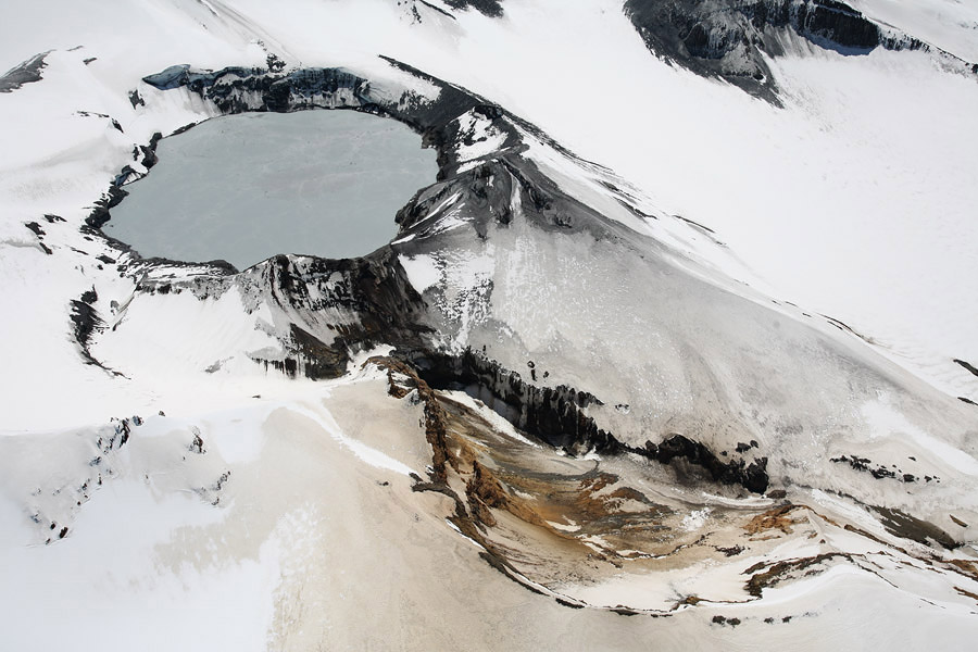
Volcanic tremor levels have been low. Gas flux and chemical concentrations of the crater lake water remain unchanged or within normal variation. The lake temperature has hovered around 22-28°C, which is broadly the median lake temperature over the past 10 years (25°C).
Using numerical modelling we estimate that 100–200MW of energy input is required to keep the lake temperature at 25°C. This equates to 10–20% of New Zealand’s geothermal electrical energy production and shows that despite the apparent quiescence, Mt Ruapehu is still a very active volcano. Like most volcanoes it has the potential to erupt with little or no warning when in a state of volcanic unrest.
Statistically, over the past 40 years most eruptions at Mt Ruapehu have occurred at temperatures that are very rarely observed (above 39°C and below 16°C).
The Volcanic Alert Level, therefore, remains at Level 1. The Volcanic Alert Level reflects the current level of volcanic activity and is not a forecast of future activity. There is no change in the Aviation Colour Code from Green.
GNS Science and the National Geohazards Monitoring Centre continues to closely monitor Mt Ruapehu for further signs of activity.
Source : Geonet / Brad Scott / Duty Volcanologist .
Photo : Geonet .