November 21 , 2019.
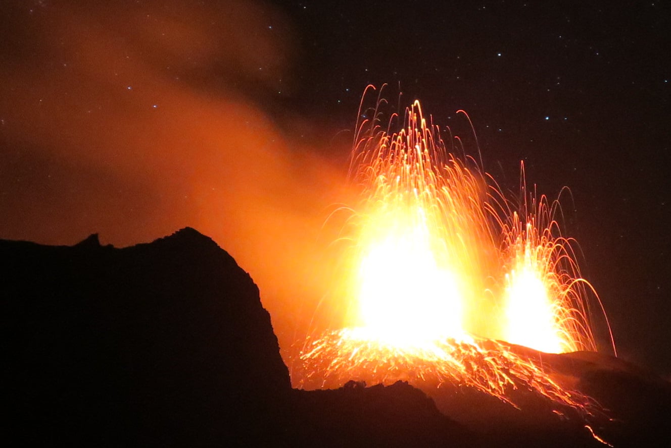
Alaska , Shishaldin :
54°45’19 » N 163°58’16 » W,
Summit Elevation 9373 ft (2857 m)
Current Volcano Alert Level: WATCH
Current Aviation Color Code: ORANGE
During the last 24 hours, seismicity at Shishaldin Volcano climbed to a level similar to that observed during other eruptive periods over the past few weeks, consistent with the resumption of eruptive activity at the volcano. This is further supported by strong surface temperatures observed in cloudy satellite images. No ash plumes have been detected. Seismicity dropped abruptly at around 3:40 AM this morning and remains at a relatively low level. This suggests that eruptive activity may have once again paused. No gas plume was seen in clear webcam views this morning.
Shishaldin is monitored by local seismic and infrasound sensors, satellite data, web cameras, a telemetered geodetic network, and distant infrasound and lightning networks.
Source : AVO.
Photo : Loewen, Matt , 15 Aout 2018.
Italy , Stromboli :
Weekly bulletin from November 11, 2019 to November 17, 2019 (published on November 19, 2019)
SUMMARY OF THE STATUS OF ACTIVITY
In light of the surveillance data, we highlight:
1) VOLCANOLOGICAL OBSERVATIONS: During this period, a normal explosive activity of Strombolian type was observed, accompanied by degassing activities. The hourly frequency of the explosions fluctuated between medium-high values (15 events / h on November 16) and high values (24 events / h on November 14). The intensity of the explosions was mainly low in the North and Middle-Upper Crater Zone in the Center-South Crater Zone.
2) SISMOLOGY: The seismological parameters do not show any significant changes.
3) DEFORMATIONS: There is no significant change regarding permanent GPS networks and Tilt meters.
4) GEOCHEMISTRY: The flow of SO2 is at an average level. The isotopic ratios of helium dissolved in the thermal layer remain unchanged for the mean-low values (data of 23/10/2019). The CO2 / SO2 ratio is at an average value.
VOLCANOLOGICAL OBSERVATIONS
Analysis of the images recorded by the cameras at 400 meters, 190 meters and Punta dei Corvi allowed us to characterize the eruptive activity of Stromboli. During the reporting period, explosive activity was primarily generated by at least three (3) eruptive vents located in the North crater area and by at least three (3) eruptive vents located in the South Central Crater Zone. All the mouths are placed inside the depression which occupies the terrace of the crater. Due to a technical breakdown between November 17 at 10:00 UTC and the end of the analyzed period (November 17 at 24:00), the video signal from the cameras was absent.
In the North zone, the explosions mainly involved low-intensity events (less than 80 m high) emitting coarse materials (lapilli and bombs). In many explosions, the emitted products covered the outer slopes of the area facing the Sciara del Fuoco and some blocks rolled a few hundred meters before stopping along the Sciara. The average frequency of the explosions was variable between 6 and 16 events / h. The explosive activity of the three mouths in the Center-Sud region has resulted in mixed coarse material emissions for medium intensity (less than 150 m high) and sometimes high (greater than 250 m height). In some explosions, the products fell back into the upper part of the Sciara. The frequency of explosions in the surveillance zone varied between 7 and 13 events / h.
The amplitude of volcanic tremor showed low to medium values.
Source : INGV.
Lire l’article en entier : file:///C:/Users/Utilisateur/AppData/Local/Packages/Microsoft.MicrosoftEdge_8wekyb3d8bbwe/TempState/Downloads/BollettinoStromboli20191119%20(1).pdf
Photo : Andrey Nikiforov .
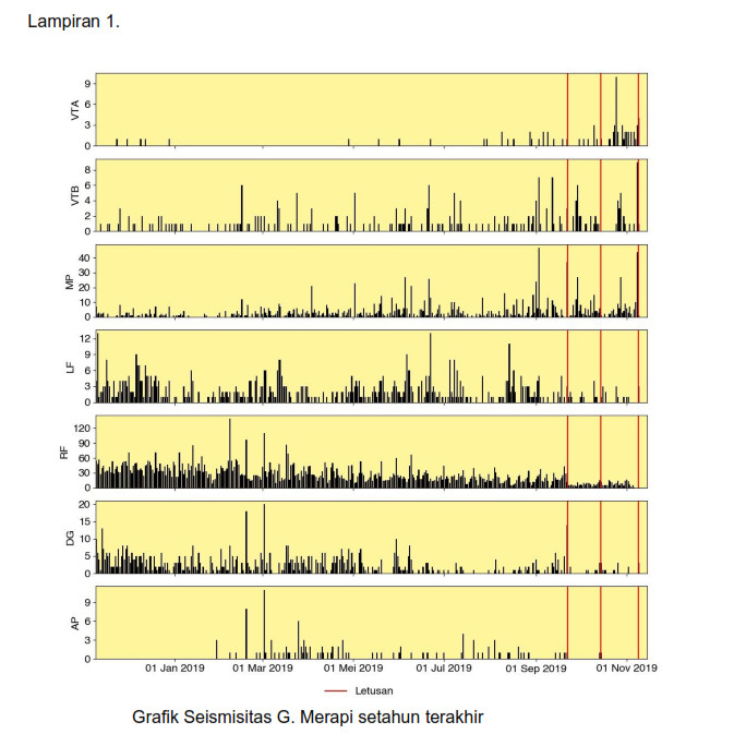
Indonesia , Merapi :
Press release on the Merapi eruption of November 17, 2019.
After the eruption of November 9, 2019, November 15 and 16, 2019, seismicity increased again. The seismographs record a mean volcano-tectonic seismic activity (VTA) of 15 events / day and a multiphase (MP) signal 75 times / day. On 17 November, from 00:00 to 11:00, VTA-type earthquakes were recorded 3 times, 4 times for VTB and 16 MP. This increase in seismicity is thought to reflect the accumulation below the surface of the gas pressure dome from the magma chamber at a depth of> 3 km.
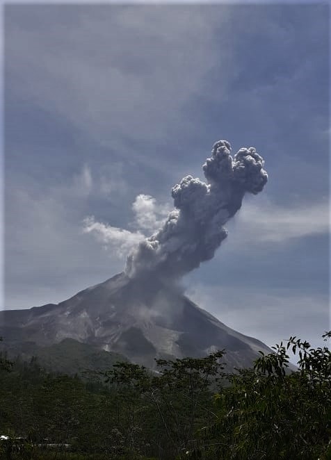
On Sunday, November 17, 2019, at 10:46 am, western time of Indonesia, an eruption was recorded on a seismogram with an amplitude of 70 mm and a duration of 155 seconds. A hot cloud of avalanche slides on less than 1 km in K. Gendol. The column of eruption smoke is ± 1000 m above the summit. To anticipate volcanic ash disruption for aircraft, an Orange color code (VONA) was issued with the Volcanoes Observation Code for aviation. Ash rains are reported to have occurred around Mount Merapi, with a dominant trend towards the western sector up to 15 km from the summit, which is located around Dukun District, Magelang Regency.
This type of eruption can still occur, indicating that magma supply from the magma chamber is still ongoing. The danger of this eruption in the form of hot clouds from collapses of lava dome materials and volcanic materials with a danger zone of less than 3 km. The volume of the dome is 416,000 m3 based on the UAV data of 30 October 2019.
Communities should remain calm and practice their activities as usual outside the 3 km radius around the summit of Mount Merapi.
Source : BPPTKG.
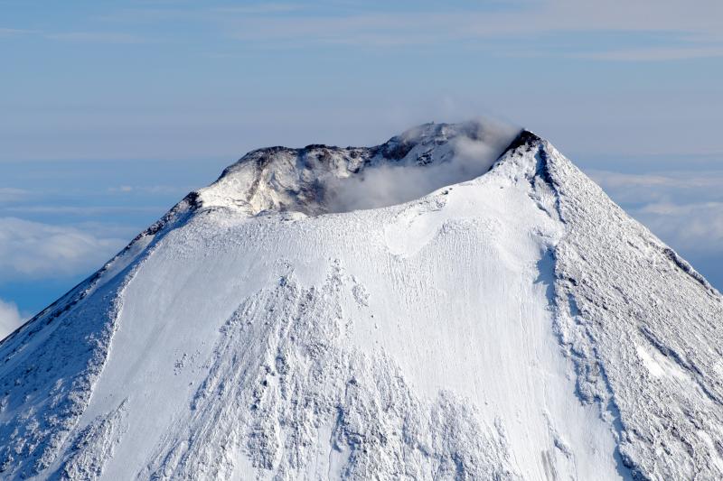
Japan , Suwanosejima :
29.638°N, 129.714°E
Elevation 796 m
JMA reported that incandescence at Suwanosejima’s Ontake Crater was visible during 8-15 November. Occasional eruptive events during 13-15 November generated grayish white plumes that rose as high as 1.5 km above the crater rim. Ashfall was reported in Toshima Village (4 km SSW) on 14 November. The Alert Level remained at 2 (on a 5-level scale).
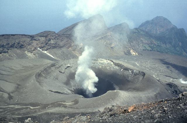
A steam plume rises above On-take, the summit crater of Suwanose-jima volcano. The 8-km-long, spindle-shaped island of Suwanose-jima consists of a stratovolcano with two historically active summit craters. The dipping escarpment at the top of the photo is the NW wall of a large breached crater that extends to the sea on the east flank. The horseshoe-shaped crater was formed by edifice collapse. Suwanose-jima, one of Japan’s most frequently active volcanoes, has been in a state of intermittent strombolian activity since 1949.
The 8-km-long, spindle-shaped island of Suwanosejima in the northern Ryukyu Islands consists of an andesitic stratovolcano with two historically active summit craters. The summit of the volcano is truncated by a large breached crater extending to the sea on the east flank that was formed by edifice collapse. Suwanosejima, one of Japan’s most frequently active volcanoes, was in a state of intermittent strombolian activity from Otake, the NE summit crater, that began in 1949 and lasted until 1996, after which periods of inactivity lengthened. The largest historical eruption took place in 1813-14, when thick scoria deposits blanketed residential areas, and the SW crater produced two lava flows that reached the western coast. At the end of the eruption the summit of Otake collapsed forming a large debris avalanche and creating the horseshoe-shaped Sakuchi caldera, which extends to the eastern coast. The island remained uninhabited for about 70 years after the 1813-1814 eruption. Lava flows reached the eastern coast of the island in 1884. Only about 50 people live on the island.
Source: Japan Meteorological Agency (JMA) , GVP.
Photo : Yukio Hayakawa, 1998 (Université Gunma).