September 12, 2019.
Italy / Sicily , Etna :
37.748°N, 14.999°E
Elevation 3295 m
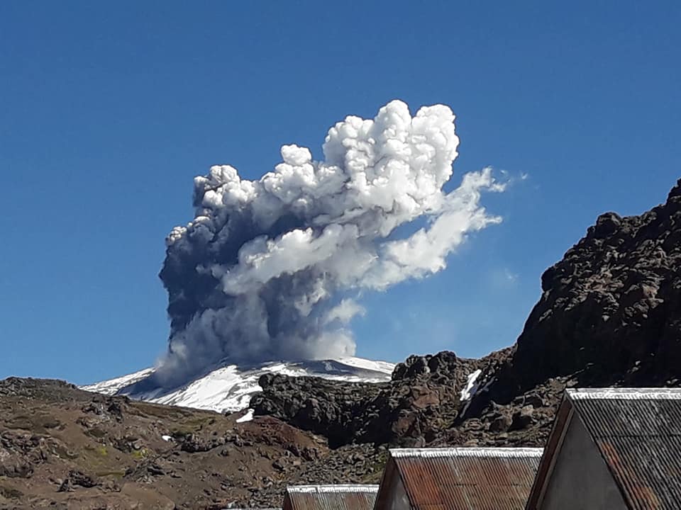
INGV reported that the mean amplitude of volcanic tremor at Etna had been increasing. Notably, the increase since mid-August had reached significant values by 6 September and were comparable to those values recorded just before the December 2018 eruption, and higher than those observed before the eruptive episodes during May-July 2019. Inclement weather prevented visual observations of the summit craters, though mountain guides reported characteristic sounds of Strombolian activity at the Bocca Nuova crater on 6 September.
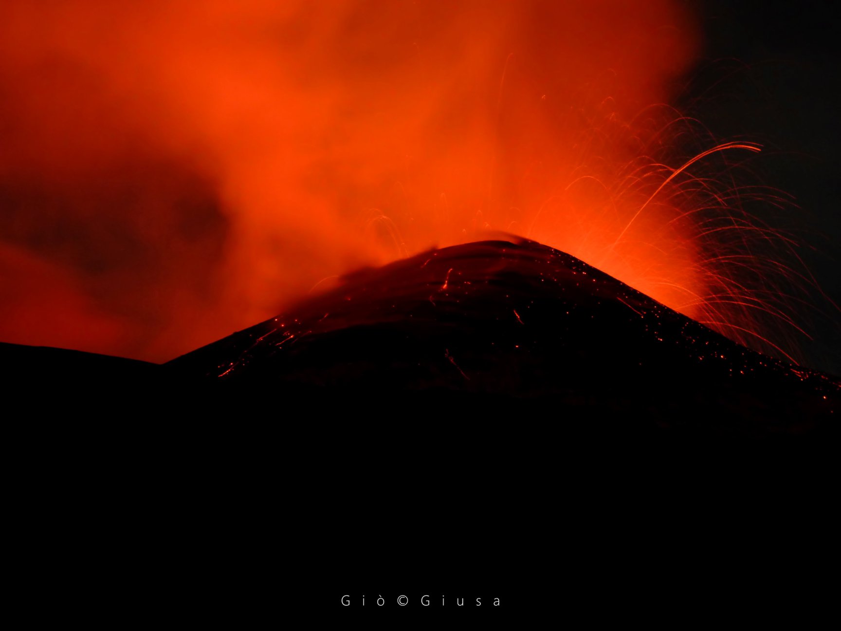
A sudden increase in volcanic tremor amplitude was recorded at 0449 on 9 September, and by 0536 Strombolian activity at Northeast Crater (NEC) was visible. At 1050 volcanic tremor amplitude again increased, with signals localized beneath NEC. Diffuse ash plumes rose from the crater and dissipated near the summit.
Still no communication from the INGV.
Source:Sezione di Catania – Osservatorio Etneo (INGV) , GVP.
Photo : Gio Giusa .
Kamchatka , Ebeko :
VOLCANO OBSERVATORY NOTICE FOR AVIATION (VONA).
Issued: September 12 , 2019
Volcano: Ebeko (CAVW #290380)
Current aviation colour code: ORANGE
Previous aviation colour code: orange
Source: KVERT
Notice Number: 2019-132
Volcano Location: N 50 deg 41 min E 156 deg 0 min
Area: Northern Kuriles, Russia
Summit Elevation: 3791.68 ft (1156 m)
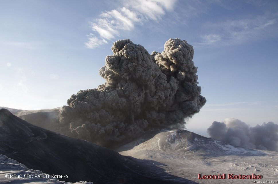
Volcanic Activity Summary:
A moderate eruptive activity of the volcano continues. According to visual data by volcanologists from Severo-Kurilsk, explosions send ash up to 2.0 km a.s.l., an ash cloud drift to the south of the volcano.
A moderate eruptive activity of the volcano continues. Ash explosions up to 19,700 ft (6 km) a.s.l. could occur at any time. Ongoing activity could affect low-flying aircraft and airport of Severo-Kurilsk.
Volcanic cloud height:
5904-6560 ft (1800-2000 m) AMSL Time and method of ash plume/cloud height determination: 20190912/0242Z – Visual data
Other volcanic cloud information:
Distance of ash plume/cloud of the volcano: 3 mi (5 km)
Direction of drift of ash plume/cloud of the volcano: S
Time and method of ash plume/cloud determination: 20190912/0242Z – Visual data
Source : Kvert.
Photo : L. Kotenko, IVS FEB RAS
Chile , Copahue :
37.856°S, 71.183°W
Elevation 2953 m
OVDAS-SERNAGEOMIN reported that seismicity at Copahue increased at 1250 on 9 September, characterized by increased amplitude of continuous tremor. Anomalies in the seismic signals suggested elevated surface activity, though cloudy weather prevented visual observations. According to the Buenos Aires VAAC diffuse steam emissions recorded by the webcam on 10 September rose to 3.5 km (11,000 ft) a.s.l. and possibly contained minor amounts of ash. The Alert Level remained at Yellow (second lowest level on a four-color scale); SERNAGEOMIN recommended no entry into a restricted area within 500 m of the crater. ONEMI maintained the Alert Level at Yellow (the middle level on a three-color scale) for the municipality of Alto Biobío.
Special Volcanic Activity Report (REAV) Biobío Region, Copahue Volcano, 9 September 2019, 17:15 local time (mainland Chile)
The National Geological and Mining Service of Chile (Sernageomin) discloses the following PRELIMINARY information, obtained through monitoring equipment of the National Volcanic Monitoring Network (NVRN), processed and analyzed at the Volcanological Observatory of the South Andes ( OVDAS)
On Monday, September 9, 2019 at 12:50 local time (15:50 UTC), the volcanic monitoring stations installed near the Copahue volcano recorded an increase in the amplitude of the continuous tremor, which is maintained until the publication of this report. . This episode showed a maximum reduced displacement (DRc) of 2.5 cm2 with a dominant frequency of 2.6 Hz observed in the « Copahue » seismological station (COP). In addition, seismic anomalies were recorded, consisting of a transient decrease in the amplitude of the continuous tremor signal, which could be related to an increase in surface activity.

The high degree of cloudiness did not allow us to clearly observe the crater area. Similarly, no ash emissions related to this event were perceived. Fluctuations in the continuous tremor signal recorded in recent months, as evidenced by events such as the one occurring today, suggest a certain instability of the system that could be caused by a slow magmatic contribution to more superficial levels. Due to the above, there are still conditions that would allow greater instability of the volcanic system, involving the emission of ash and / or the possibility of minor explosions affecting areas near the crater. For the above, the technical alert level is kept at Yellow level.
Sources: Buenos Aires Volcanic Ash Advisory Center (VAAC), Oficina Nacional de Emergencia-Ministerio del Interior (ONEMI), Servicio Nacional de Geología y Minería (SERNAGEOMIN). GVP.
Photos : Sernageomin , Auteur inconnu.
Indonesia , Tangkuban Parahu :
Responses regarding sulfur odors reported in the cities of Cimahi and West Bandung Regency.
September 12, 2019
Regarding information on the smell of sulfur expected to come from the activity of Tangkuban Parahu on Wednesday afternoon of September 11, 2019, it was felt enough in some remote areas of the crater, in the city of Cimahi and West Bandung. The Geological Disaster Mitigation Team (PVMBG) immediately checked the area by measuring the gas around the Ratu crater, on the Parahu Tangkuban.

The results of the measurements show that there is no indication of a significant increase in the concentration of CO2, SO2. The results of observations on Kawag Ratu’s lips on September 11, 2019, at 21:30 West Indonesia time, showed moderate to thick smoke up to about 180 m above the surface of the crater. The eruption column was not observed but there was a pungent smell of sulfur accompanied by a moderate intensity plume. The results of gas observations with Drager measured CO2 concentrations: 0.020% by volume and SO2: 4.6 ppm. The concentrations of these gases are still relatively lower than the results of the previous measurements, on 1 August 2019. The monitoring of the temperature of the crater with thermal camera has also not shown an increase in temperature. The current tremor amplitude has a dominant value around 25 mm.
Based on the analysis of the monitoring data, it can be concluded that the smell of gas at a relatively distant distance is possible due to strong winds that dominate towards the South-South-West, namely towards the areas where are located in Cimahi City and West Bandung Regency. The status of Mount Tangkuban Parahu is currently at Level II (Waspada) with a recommended hazard distance of 1.5 km around the crater. The PVMBG Geological Survey urges people outside the 1.5 km radius to remain calm and active, but to keep abreast of the volcanic activity of the PVMBG and the local government / BPBD.
Source : PVMBG
Photo : mnctrijaya.com