
April 14 , 2023.
Italy , Vulcano :
WEEKLY NEWSLETTER, from April 03, 2023 to April 09, 2023 (issue date April 11, 2023)
ACTIVITY STATUS SUMMARY
In the light of the monitoring data, it is highlighted:
1) Temperature of the crater fumaroles: The temperatures recorded on the edge of the crater remain at high values compared to those preceding the current crisis.
2) CO2 fluxes in the crater area: stable CO2 fluxes on medium-high degassing values (about 10,000 g/m2/day).
3) SO2 flux in the crater area: decreasing towards an average level
4) Geochemistry of fumarolic gases: There is no new data available
5) CO2 fluxes at the base of the La Fossa cone and in the Vulcano Porto area: In the Camping Sicilia and Rimessa sites, the CO2 fluxes show stable values but always above background levels; on the P4max site and Faraglione the flows fluctuate at average levels.
6) Geochemistry of the thermal aquifers: The temperature in the Camping Sicilia well is at high values, while the conductivity is stable; in the Bambara well, no significant change in the monitored parameters was observed.
7) Local seismicity: Low occurrence rate of local micro-seismicity.
8) Regional seismicity: No earthquakes with a local magnitude equal to or greater than 1.0 were recorded.
9) Deformations – GNSS: The network of permanent GNSS stations has not recorded any significant variations.
10) Deformations – Inclinometry: The inclinometric network did not record any significant variations.
11) Gravimetry: No significant change was recorded.
12) Other Comments: Mobile GNSS.
The time series acquired so far by the mobile GNSS network do not show significant variations around the Porto di Levante area.
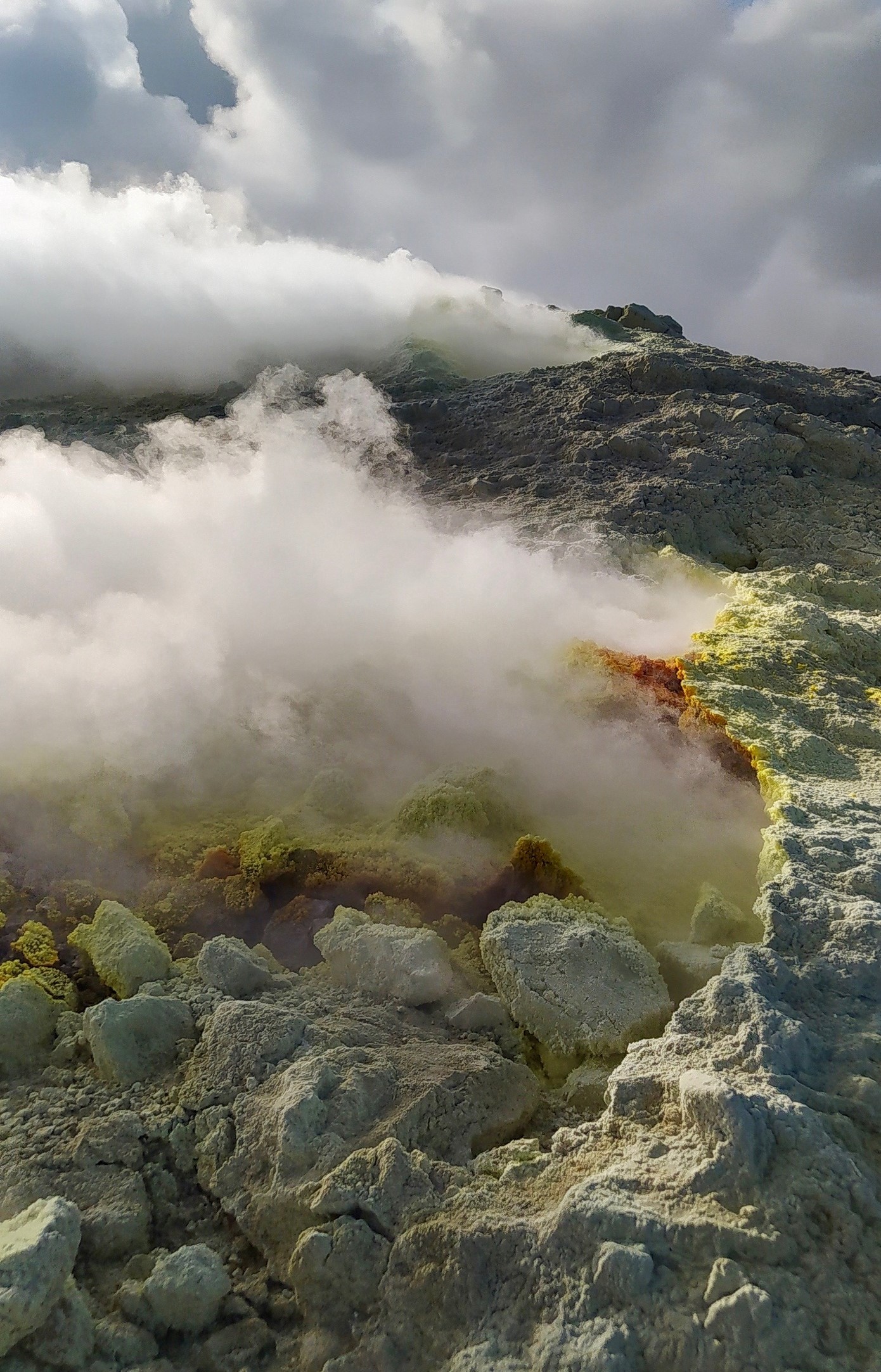
CRATER FUMEROLES TEMPERATURE:
Along the entire summit fracture line, the emission temperature showed an hourly maximum of 385°C (T3) over the past 7 days. The hourly temperature range recorded on board is 277 to 384°C. The maximum temperature signal (T3) shows an upward trend since April 9, contrary to what was recorded in the nearby F5AT fumarole, more affected by the effects of atmospheric disturbances. It is confirmed that the thermal anomaly is still supported by a stable vapor flow at values higher than those preceding the current crisis.
Source : INGV.
Photo : G. De Astis (INGV-Rome1)
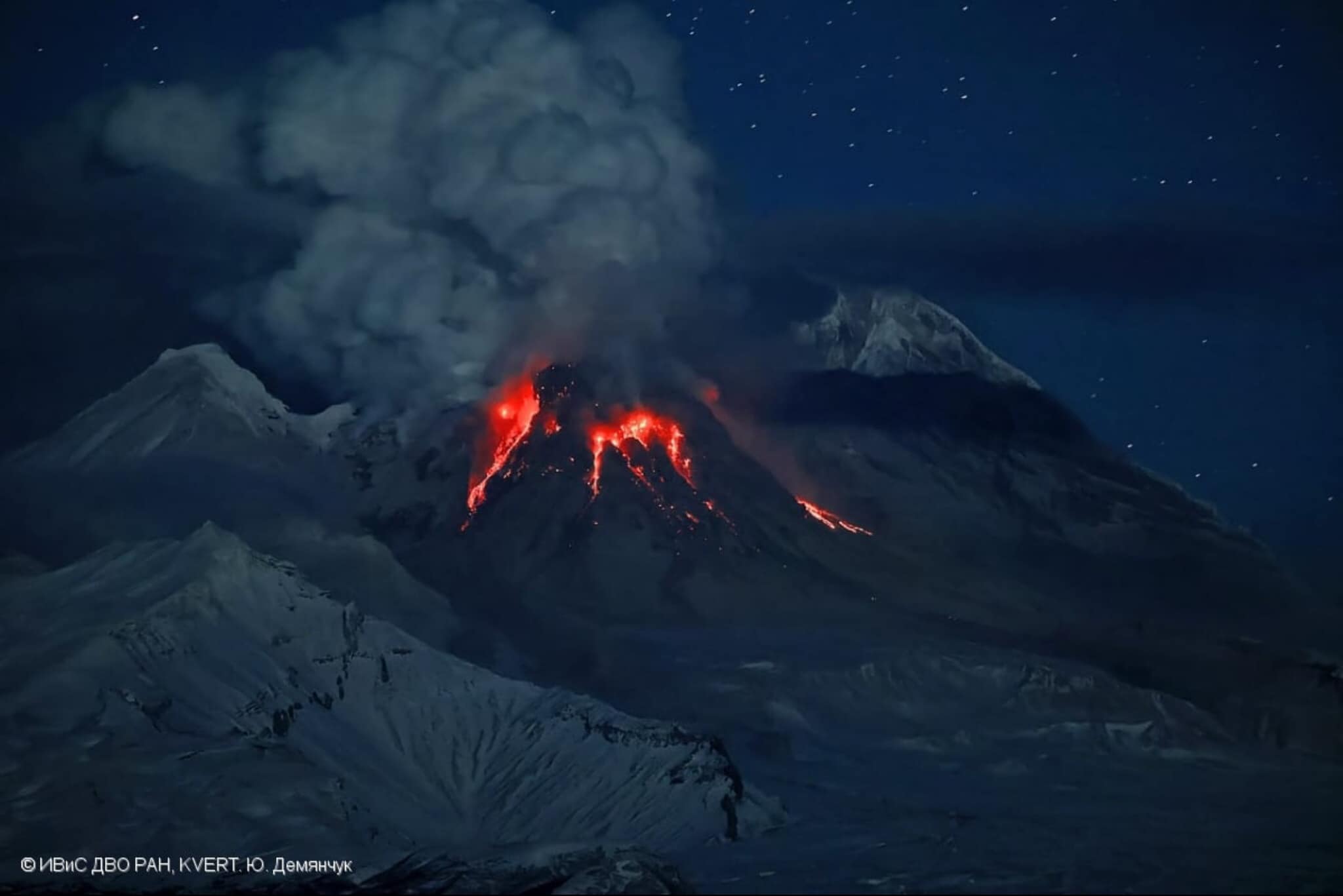
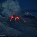
Kamchatka , Sheveluch :
VOLCANO OBSERVATORY NOTICE FOR AVIATION (VONA)
Issued: April 13 , 2023
Volcano: Sheveluch (CAVW #300270)
Current aviation colour code: ORANGE
Previous aviation colour code: orange
Source: KVERT
Notice Number: 2023-58
Volcano Location: N 56 deg 38 min E 161 deg 18 min
Area: Kamchatka, Russia
Summit Elevation: 3283 m (10768.24 ft), the dome elevation ~2500 m (8200 ft)
Volcanic Activity Summary:
An explosive eruption of the volcano continues. Satellite data by KVERT showed an ash plume extended about 415 km to the east-south-east from the volcano.
An eruption of the volcano continues. Ash explosions up to 10 km (32,800 ft) a.s.l. could occur at any time. Ongoing activity could affect international and low-flying aircraft.
Volcanic cloud height:
4000-4500 m (13120-14760 ft) AMSL Time and method of ash plume/cloud height determination: 20230413/0510Z – Himawari-9 14m15
Other volcanic cloud information:
Distance of ash plume/cloud of the volcano: 415 km (258 mi)
Direction of drift of ash plume/cloud of the volcano: ESE / azimuth 120 deg
Time and method of ash plume/cloud determination: 20230413/0510Z – Himawari-9 14m15
ALASKA VOLCANO OBSERVATORY INFORMATION STATEMENT
U.S. Geological Survey
Thursday, April 13, 2023, 11:01 AM AKDT (Thursday, April 13, 2023, 19:01 UTC)
Sheveluch Volcano, located in the Russian Far East on the Kamchatka Peninsula (56.65°N 161.36°E), erupted explosively on April 10 (Alaska date) and produced a large volcanic ash and gas cloud up to ~40,000 feet (12.2 km) above sea level. Over the past several days, the volcanic cloud has drifted eastward over Alaskan air space. Although this cloud poses a potential hazard to aviation and has disrupted some flights, no ashfall is expected on Alaska communities.
Whenever ashfall is expected in Alaska, the Alaska Volcano Observatory works cooperatively with the National Weather Service Anchorage Forecast Office, which issues products to advise the public on the timing and severity of the ashfall.
The airborne cloud is being tracked by the National Weather Service Alaska Aviation Weather Unit and Anchorage Volcanic Ash Advisory Center.
Source : Kvert. AVO.
Photo : Yu. Demyanchuck / IVS FEB RAS KVERT via Olga Girina.
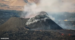
Colombia , Nevado del Ruiz :
Manizales, April 13, 2023 10:05 a.m.
Regarding the monitoring of the activity of the NEVADO DEL RUIZ VOLCANO, the MINISTRY OF MINES AND ENERGY through the COLOMBIAN GEOLOGICAL SERVICE (SGC) informs that:
Seismic activity associated with rock fracturing continues within the volcanic edifice.
Yesterday this type of seismicity increased compared to the day before (April 11). During the morning, this seismicity was located 3.5 km southwest of the volcano, at depths between 2 and 4 km and at a distance from the crater of 2 to 6 km. The maximum magnitude reached in this sector was 1.9 corresponding to the 8:03 a.m. earthquake, located 4 km southwest of the crater and about 4 km deep from the summit of the volcano. In the afternoon, the earthquakes were recorded mainly in the North-North-East sector of the volcano, at depths between 3 and 5 km, the maximum magnitude was M 1.8, associated with the earthquake of 3:57 p.m., located 2 km north-northeast of the crater, 4 km deep.
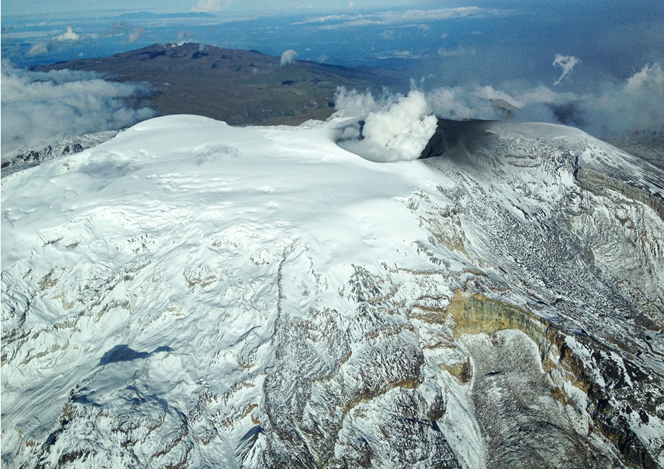
On the other hand, the seismicity linked to the movement of fluids inside the volcanic conduits was associated with a continuous and pulsatile emission of ash. The maximum column height
of gas and / or ash observed was 1800 m, measured from the summit of the volcano with a direction of dispersion which oscillated between the South-West and the North-West. The emission of sulfur dioxide into the atmosphere maintained levels similar to those of yesterday. Localized thermal anomalies continue to be observed in the Arenas crater.
Source et photo : SGC.
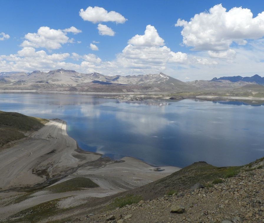
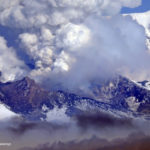
Chile , Laguna del Maule :
Special Report on Volcanic Activity (REAV), Maule region, Laguna del Maule volcanic complex, April 13, 2023, 06:10 a.m. local time (mainland Chile)
The National Geology and Mining Service of Chile (Sernageomin) announces the following PRELIMINARY information, obtained through the monitoring equipment of the National Volcanic Monitoring Network (RNVV), processed and analyzed at the Volcanological Observatory of the Andes del Sud ( Ovdas):
On Thursday April 13 at 04:02 local time (08:02 UTC), the monitoring stations installed near the Laguna del Maule volcanic complex recorded a seismic swarm, associated with a volcano-tectonic seismic swarm (VT). At the time of issuing this report, there were 234 events, located 9.5 km west-southwest of the center of the lagoon.
The characteristics of the earthquake of greatest magnitude recorded for the moment after its analysis are as follows:
ORIGINAL TIME: 04:52 local time (08:52 UTC)
LATITUDE: 36.107°S
LONGITUDE: 70.598°E
DEPTH: 6.8km
LOCAL MAGNITUDE: 3.2 (ML)
Comments:
During the morning, there is an increase in volcano-tectonic activity in the complex, from which an event of M 3.2 is detached.
At the time of issuing this report, volcano-tectonic (VT) type activity continues with events of lower magnitude.
The volcanic technical alert remains at the Yellow level.
Source : Sernageomin.
Photo : Segemar.
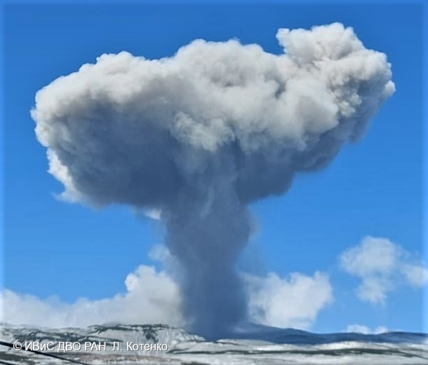
Russia / Kuril Islands , Ebeko :
VOLCANO OBSERVATORY NOTICE FOR AVIATION (VONA)
Issued: April 14 , 2023
Volcano: Ebeko (CAVW #290380)
Current aviation colour code: ORANGE
Previous aviation colour code: orange
Source: KVERT
Notice Number: 2023-59
Volcano Location: N 50 deg 41 min E 156 deg 0 min
Area: Northern Kuriles, Russia
Summit Elevation: 1156 m (3791.68 ft)
Volcanic Activity Summary:
A moderate explosive activity of the volcano continues. According to satellite data by KVERT, an explosion sent ash up to 3.5 km a.s.l., an ash cloud 25×7 km in size is drifting to the northnortheast of the volcano.
A moderate explosive eruption of the volcano continues. Ash explosions up to 6 km (19,700 ft) a.s.l. could occur at any time. Ongoing activity could affect low-flying aircraft and airport of Severo-Kurilsk.
Volcanic cloud height:
3500 m (11480 ft) AMSL Time and method of ash plume/cloud height determination: 20230414/0040Z – Himawari-9 14m15
Other volcanic cloud information:
Distance of ash plume/cloud of the volcano: 72 km (45 mi)
Direction of drift of ash plume/cloud of the volcano: NNE / azimuth 24 deg
Time and method of ash plume/cloud determination: 20230414/0140Z – Himawari-9 14m15
Source : Kvert
Photo : L. Kotenko, IVS FEB RAS

No comment yet, add your voice below!