August 29 , 2019.
Italy , Stromboli :
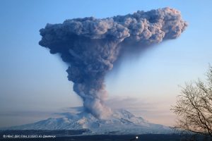
COMMUNICATION on the volcanic activity of August 28, 2019, 10:17:21 (UTC) – Stromboli.
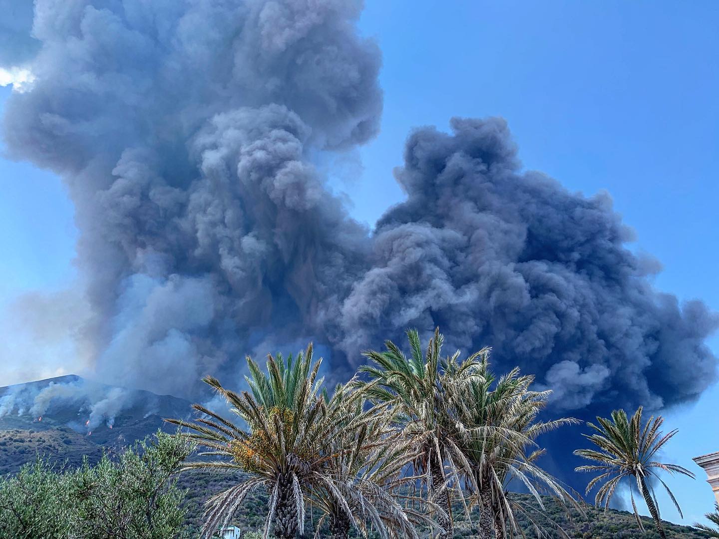
The National Institute of Geophysics and Volcanology, Etneo Observatory, informs that the monitoring networks recorded at 12:17 hours (10:17 UTC) a strong explosion.
The explosion hit the center-south zone of the stromboli crater terrace. The products created by the explosion fell on the entire crater terrace and along the Sciara del Fuoco rolling until reaching the coastline. The phenomenon in question is also visible on the seismic plot.
https://www.facebook.com/PieroLeone80/videos/10212003744769401/
COMMUNICATION on the volcanic activity of August 28, 2019, 11:41:57 (UTC) – STROMBOLI.
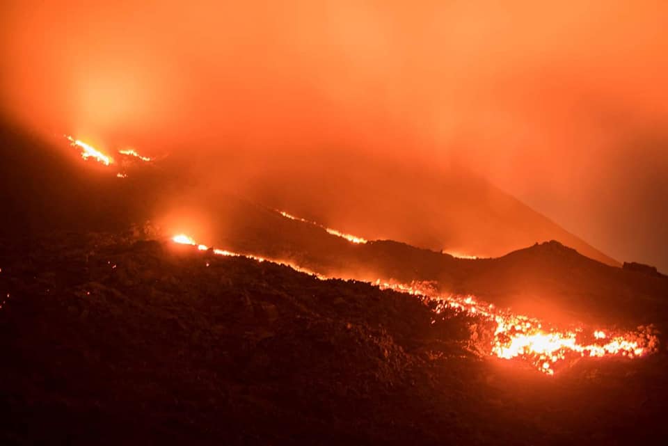
The National Institute of Geophysics and Volcanology, Osservatorio Etneo, reports that the high-intensity explosion at 1017 UTC may be classified as a breakthrough and affected the Stromboli crater area. In particular, the event concerned mainly the Center-South sector of the crater and, secondarily, the North zone. The latter caused a pyroclastic flow that spilled along the Sciara del Fuoco and developed for several hundred meters in the sea. The area of fallout of the products of the explosion has affected the entire summit. of the volcano and the eruption column has reached a height of more than 2 km.
Analysis of soil deformation data did not reveal any significant anomalies. The SO2 flow did not show any specific anomalies and remained under a medium-level degassing regime.
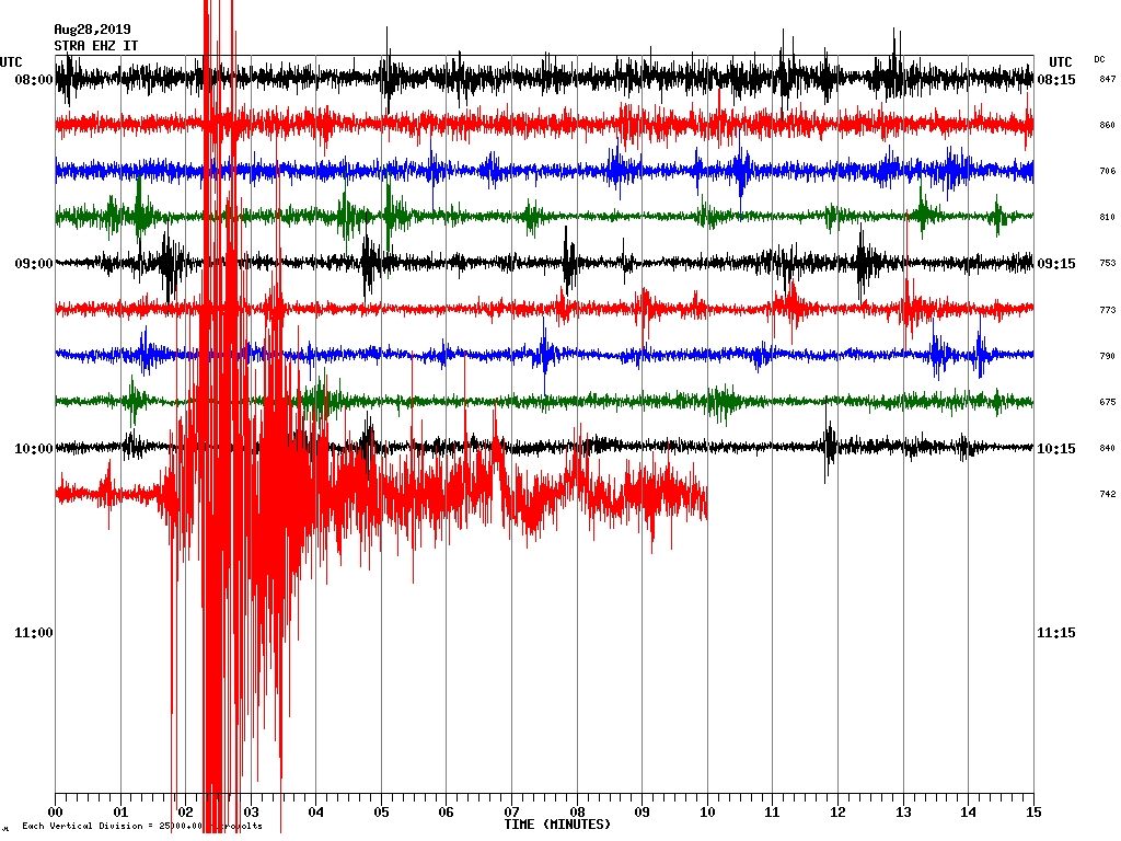
From the analysis of the seismic plot, we can observe, from 10:16 UTC, a sequence of explosive events, the most energetic occurred at 10:17 UTC. From a purely seismic point of view, this sequence can be considered comparable to the episode of July 3rd. In addition, a sudden increase in the average amplitude of volcanic tremor was observed in conjunction with the explosive event.

NEW PAROXYMAL EXPLOSION AT STROMBOLI ON 28TH AUGUST 2019 AT 1017 GMT.
On 28 August 2019 at 10:17:15 UTC, the geophysical monitoring network of the Experimental Geophysical Laboratory of the University of Florence – Department of Earth Sciences recorded a powerful explosive event associated with very high geophysical parameters. The parameters of seismicity and deformation place this explosion among those defined as paroxysmal.
The event was accompanied by a signal of strong deformation of the ground (11 μrad at 800 m from the OHO tilt-meter at Rina Grande). The deformation has characteristics compatible with a swelling of the volcano started at least 5 minutes before the explosion. This deformation is comparable to that recorded during the paroxysmal event of March 15, 2007.
The flow generated a small tsunami wave recorded by the Punta Labronzo buoy (PLB) with a positive peak of 0.2 m and a maximum increase of 0.6 m (peak-to-peak) at 10:17:50.
BASED ON THE EXPERIENCE OF THE LATEST TWO REGISTERS OF PAROXYMAL EVENTS, IT IS POSSIBLE TO PRE-ALERT THE NATIONAL AND REGIONAL CIVIL PROTECTION SERVICE 10 MINUTES BEFORE THE EXPLOSIVE EVENT.
The paroxysmal explosion occurred without any particular changes in the monitored parameter levels before and after the event. All parameters were held on stationary values between high and very high.
Source : INGV Vulcani. LGS – Laboratorio Geofisica Sperimentale
Vidéo : Pietro Centineo.
Photo : Marta Lamberti / Amici dell’Isola di Stromboli , Stromboli Adventures.
Kamchatka , Sheveluch :
VOLCANO OBSERVATORY NOTICE FOR AVIATION (VONA).
Issued: August 29 ,2019.
Volcano:Sheveluch (CAVW #300270)
Current aviation colour code:ORANGE
Previous aviation colour code:orange
Source:KVERT
Notice Number:2019-125
Volcano Location:N 56 deg 38 min E 161 deg 18 min
Area:Kamchatka, Russia
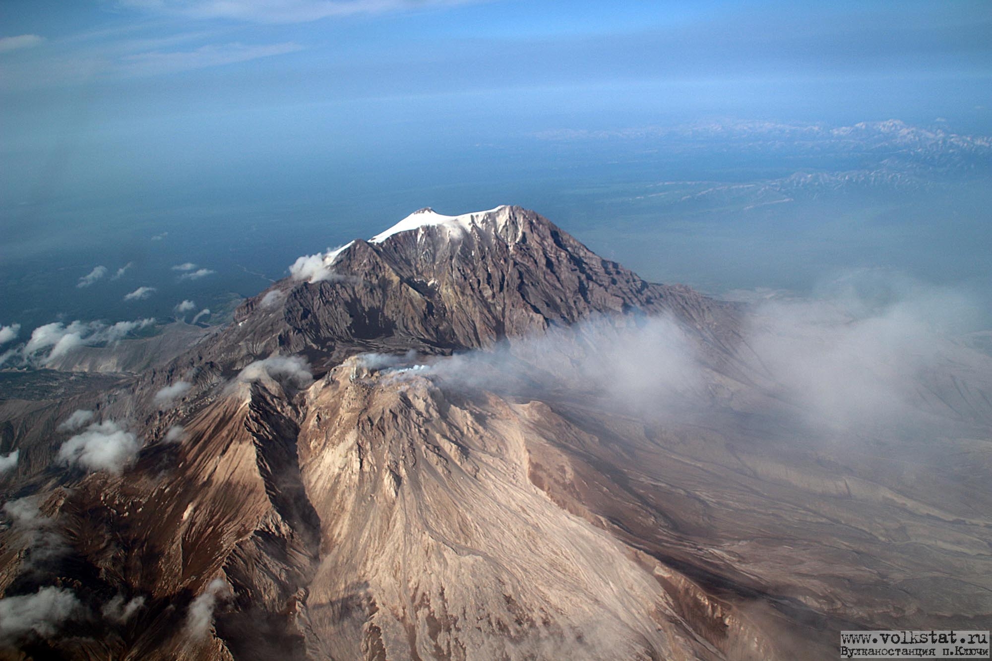
Summit Elevation:10768.24 ft (3283 m), the dome elevation ~8200 ft (2500 m)
Volcanic Activity Summary:
A growth of the lava dome continues, a strong fumarolic activity and an incandescence of the dome blocks and hot avalanches accompanies this process. According to satellite data, an ash plume up to 10 km a.s.l. drifted to the north from the volcano.
Explosive-extrusive eruption of the volcano continues. Ash explosions up to 32,800-49,200 ft (10-15 km) a.s.l. could occur at any time. Ongoing activity could affect international and low-flying aircraft.
Volcanic cloud height:
29520-32800 ft (9000-10000 m) AMSL Time and method of ash plume/cloud height determination: 20190829/0310Z – Himawari-8
Other volcanic cloud information:
Distance of ash plume/cloud of the volcano: 26 mi (42 km)
Direction of drift of ash plume/cloud of the volcano: NNE / azimuth 12 deg
Time and method of ash plume/cloud determination: 20190829/0310Z – unknown
Source : Kvert .
Photo : I. Borisov et V. Tsvetkov.
Indonesia , Tangkuban Parahu :
6.77°S, 107.6°E |
Elevation 2084 m
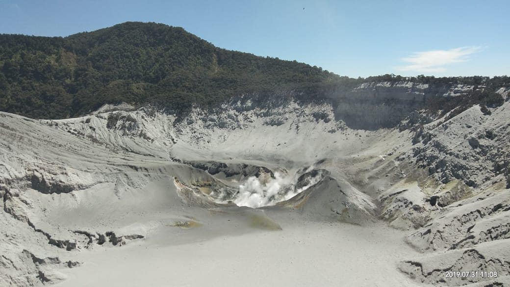
PVMBG reported that during 19-25 August phreatic events at Tangkubanparahu’s Ratu Crater continued to produce sometimes dense gray-to-white plumes that rose as high as 200 m above the vent, and dense black ash plumes that rose as high as 180 m. Ashfall was localized around Ratu Crater. The seismic network recorded continuous tremor. The Alert Level remained at 2 (on a scale of 1-4), and the public was warned to stay 1.5 km away from the active crater.
Level of activity at Level II(WASPADA). G. Tangkuban Parahu (2084 m above sea level) erupted on July 26, 2019 at 3:48 pm: 18 Western Indonesia time with a column of ash rising to within ± 200 m from the summit (± 2284 m above sea level). Following an eruption on August 1, 2019, at 8:46 pm, western time of Indonesia, the smoke column was 180 m above the crater floor, followed by an eruption on August 2, 2019. from 0:43 am and another at 4:56 pm from western Indonesia.
Since yesterday and until this morning, the volcano was clearly visible until it was covered by fog. CCTV observed smoke from the medium-pressure, moderate-to-thick, medium-pressure main crater, the height of the smoke column reaching 180 m above the crater floor.
The seismographs, August 28, 2019, recorded:
51 earthquakes of explosion.
Tremor continuous amplitude between 1 and 10 mm, dominant value of 3 mm
Recommendation:
The community around Mount Tangkuban Parahu and visitors / tourists / mountaineers should not approach the crater at the top of Mount Tangkuban Parahu within 1.5 km of the active crater. It is recommended to temporarily close the Tangkuban Parahu Nature Park for a greater safety distance.
VONA:
The last VONA code was sent with the color code ORANGE, published on August 2, 2019 at 4:20 WIB, relating to volcanic ash emission observations at 1:45 WIB. With a height of ash column not observed.
Source: Pusat Vulkanologi dan Mitigasi Bencana Geologi , GVP .
Photo : mnctrijaya.com.
Guatemala , Pacaya :
Type of activity: Strombolian
Morphology: Composite Stratovolcano
Geographical location: 14 ° 22’50˝ Latitude N; 90 ° 36’00˝ longitude O
Height: 2,552msnm.
Weather conditions: partly cloudy
Wind: North
Precipitation: 0.5 mm
Activity:
Presence of white and sometimes blue degassing at an altitude of about 300 meters above the crater moving south. At night and early in the morning the incandescence of lava flows heading north was reflected. Seismic stations record tremors associated with the rise of magma and gases. Strombolian explosions raise materials to a height of 10 to 15 meters above the crater.
Source : Insivumeh.
Photo : David Rojas .