July 20 , 2019.
Italy / Sicily , Etna :
Summary of information contained in the latest communiqués released by the INGV-Osservatorio Etneo about the activity of Etna. ( 19/07/2019)
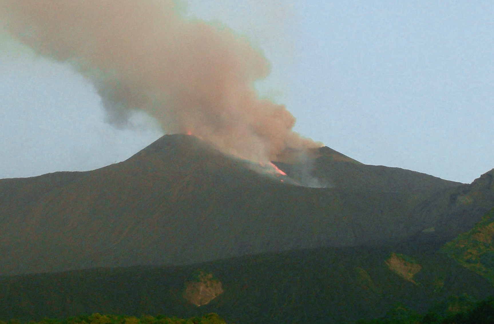
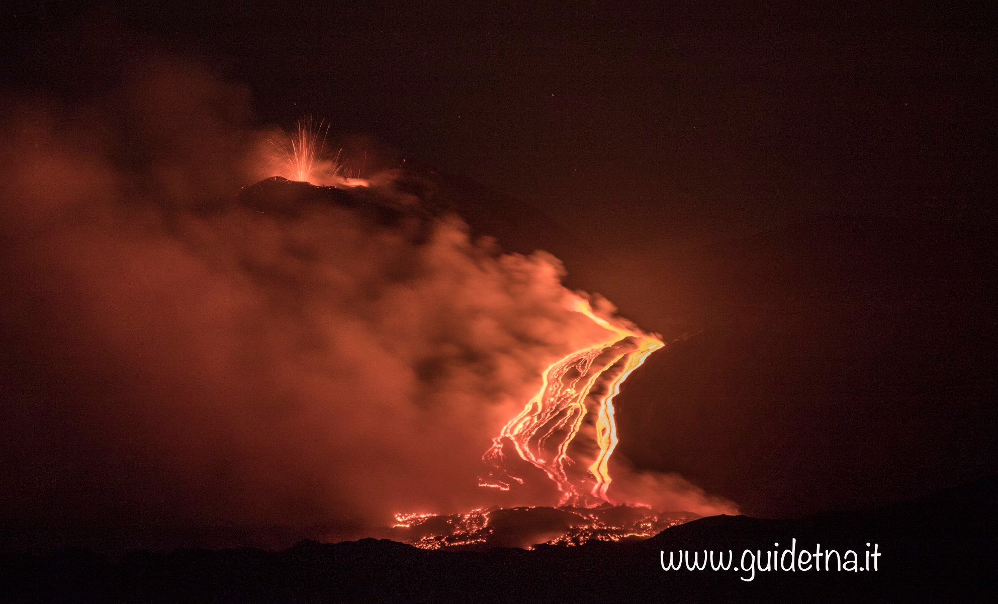
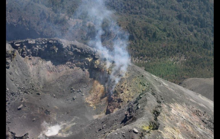
Eruptive activity continues at the New Southeast Crater (NSEC). During the night, at 23:07 UTC (01:07 local time), an effusive vent opened on the northern flank of the NSEC, which up to this moment is emitting a lava flow directed toward the western slope of the Valle del Bove. The active lava flow front had advanced about 1.5 km from its source. Instead, explosive activity at the summit vent of the NSEC has diminished after having reached a peak on the late evening. The volcanic tremor amplitude reached maximum values at about 20:30 UTC, after which it dropped but then stabilized, still at high levels. During the morning, several minor ash emissions occurred at the Northeast Crater and at the Bocca Nuova.
Around 09:00 UTC, abundant ash emission started at the Northeast Crater. Consequently, the INGV-Osservatorio Etneo declared status VONA (Volcano Observatory Notice to Aviation) RED.

The images were taken from Tremestieri Etneo (south flank of Etna) at 23:47 UTC, with Strombolian activity at the NSEC and glow from the new lava flow visible at right , and) by the high-resolution camera at Monte Cagliato at 03:38 UTC, showing the advancing lava flow and ash emission from the Northeast .
Latest two communiqués released about the eruptive activity of Etna by the INGV-Osservatorio Etneo, 19 July 2019.
VOLCANIC ACTIVITY REPORT FOR ETNA, 19 July 2019, 11:15:48 UTC.
The Istituto Nazionale di Geofisica e Vulcanologia, Osservatorio Etneo, reports that by 10:55 UTC ash emission from the Northeast Crater has ceased. Meanwhile, emission of lava from the New Southeast Crater remains constant. VONA status: ORANGE (no ash emission).
VOLCANIC ACTIVITY REPORT FOR ETNA, 19 July 2019, 13:26:24 UTC.
The Istituto Nazionale di Geofisica e Vulcanologia, Osservatorio Etneo, reports that the monitoring networks have recorded a rapid variation in the monitored parameters.
In particular, from 11.30 UTC today, there has been a rapid increase in the mean volcanic tremor amplitude. This has been accompanied by an increase also in the frequency of infrasonic signals. The sources of the volcanic tremor and of the infrasonic events are located at the New Southeast Crater. Clouds in the summit area are allowing only sporadic views of vigorous Strombolian activity at the NSEC.
ETNA, update 6:30 am Saturday 20 July
Due to the reduction of volcanic ash emissions into the atmosphere, the Crisis Unit ordered the partial reopening of the airspace of the Catania airport. Until 11 am today, Saturday, July 20, 6 aircraft will be allowed to arrive every hour: all flights will be delayed and complicated. We ask passengers to request flight information exclusively from their own airlines.
Comiso airport is fully operational.
Source : INGV Vulcani .
Photos : INGV , Etna Guide Vulcanologiche
Peru , Ubinas :
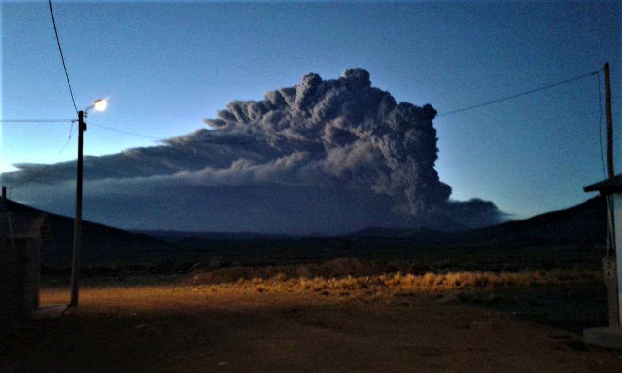
IGP recommends declaring Ubinas volcano on orange alert because of the occurrence of violent explosions, 19 July 2019
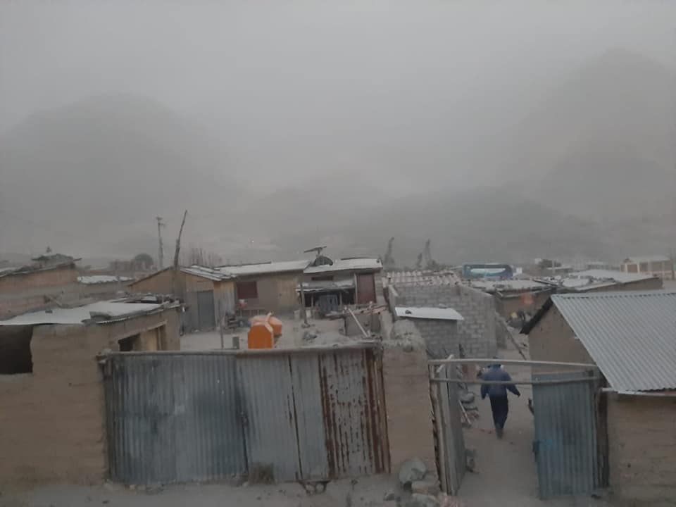
An extraordinary activity report describes in detail the occurrence of violent explosions since 2:35 this morning. Ash falls occur in the villages of the Ubinas Valley and in the region of Arequipa.
https://www.facebook.com/PressRM/videos/1156361174559042/
The Geophysical Institute of Peru (IGP), entity responsible for volcanic monitoring in the country, reports since 2:35 today an intense explosive activity on the volcano Ubinas. As a result, the IGP has prepared a new activity report in which it recommends changing the alert level from yellow to orange.
At present, ash falls have been recorded in the cities of Ubinas, Escacha, Anascapa, Matalaque, San Miguel, Huarina, Tonohaya, for which an ash dispersal alert has also been launched so that the authorities and take steps to avoid health nuisances.
Arequipa, July 19, 2019.
Alert level: YELLOW.
The Geophysical Institute of Peru (IGP) reports that the Ubinas volcano continues in an eruptive process. Currently, there are explosions and an increase in seismic activity that would be related to the intense ash emissions that affect the villages of the Ubinas Valley; therefore, it is recommended that the authorities raise the volcanic warning level from yellow to orange.
The IGP analyzed the seismic activity of the Ubina recorded between 16 and 19 July 2019. On July 19 at 2:35, there were 2 volcanic explosions and an increased seismicity (tremor type) which are related to intense emissions of ashes falling back into the Ubinas Valley. Similarly, volcanic signals related to the movement of fluids (water vapor, gas and magma) are recorded with an average of 120 events per day. The events associated with rock breaking processes inside the volcano remain high, with 140 earthquakes per day. On 17, 18 and 19 July, surveillance cameras recorded ash and gas emissions that spread to the north, east and south-east of the volcano. The monitoring of the deformation of the volcanic structure, using GNSS data (processed with fast orbits), presents no anomalies. Satellite monitoring, using information from the SENTINEL system, corroborates the direction of dispersion of ashes recorded by surveillance cameras. The data obtained from TROPOMI (SO2) and MIROVA (thermal anomalies) do not show any significant changes in the analysis period.
RECOMMENDATIONS: It is recommended that authorities raise the alert level from yellow to orange.
The IGP analyzed the seismic activity of the Ubinas recorded on July 19, 2019. During this period, 3 volcanic explosions were recorded, generating energies equivalent to earthquakes of magnitudes M5.8, M5.3 and M4. 1, respectively, as well as tremor type seismicity that would be related to intense ash emissions, which were precipitated in different districts located east and southeast of the volcano. The surveillance cameras of Ubinas, Ticsani and Yucamane volcanoes recorded the emission and dispersion of ashes and gases that affect several districts located to the east and south-east of the Ubinas crater, in the Moquegua regions. , Puno and Tacna. The monitoring of the deformation of the volcanic structure, using GNSS data (processed with fast orbits), presents no anomalies. Satellite monitoring, using information from the SENTINEL system, corroborates the direction of dispersion of ashes recorded by surveillance cameras. The data obtained from TROPOMI (SO2) and MIROVA (thermal anomalies) do not show any significant changes in the analysis period.
Source : IGP Pérou .
Video : Reportando Moquegua.
Photos : Radio Melodía AM. El Informativo
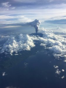
Indonesia , Bromo :
VOLCANO OBSERVATORY NOTICE FOR AVIATION – VONA.
Issued: July 19 , 2019
Volcano: Bromo (263310)
Current Aviation Colour Code: ORANGE
Previous Aviation Colour Code: orange
Source: Bromo Volcano Observatory
Notice Number: 2019BRO24
Volcano Location: S 07 deg 56 min 31 sec E 112 deg 57 min 00 sec
Area: East java, Indonesia
Summit Elevation: 7453 FT (2329 M)
Volcanic Activity Summary:
Eruption with volcanic ash cloud at 09h37 UTC (16h37 local).
Volcanic Cloud Height:
Ash-cloud is not visible
Other Volcanic Cloud Information:
The height and direction of ash column couldnot observed due to weather obscured.
Remarks:
Eruption event recorded in seismograph with maximum amplitude of 37 mm and duration of 7 minutes 14 seconds.
Report on the mudslide events in the Tengger Caldera area – G. Bromo.
It is considered that the flow of water with rocky materials combining ash and sand, occurred on July 19, 2019 around 17 hours, is an ordinary natural phenomenon that is not directly related to the eruptive activity of the G Bromo. The events are caused by the rain that occurs around the Tengger Caldera and the summit of G. Bromo with eruption events that produce volcanic ash. In addition, the Tengger caldera has a morphology characterized by a low topography surrounded by hills, so that in case of rain, the flow of water will go down the caldera, the soils surrounding the hills of the Caldera Tengger and the top of G. Bromo generally consist of bulk products. easily eroded by rainwater. Weather observations from July 1 to 18, 2019 show that generally around G. Bromo, the weather is clear to cloudy. On July 19, 2019, at 16:43 West Time Indonesia, there was drizzle. The rainfall in PGA du Bromo is 0.4 mm. The flood flow came from the southwest side of the slope of G. Bromo around G. Batok in the west. The vibration of the flood was recorded on a seismograph with a maximum amplitude of 1 mm and an earthquake duration of 3 minutes 20 seconds.
Level of activity at Level II (WASPADA). The Bromo (2,329 m above sea level) has suffered prolonged eruptions.
Since yesterday and until this morning, the volcano was clearly visible until it was covered with fog and rain. The smoke from the crater was thin, white, rising 300 meters above the summit, there was a roar and a detonation. The wind blows weakly in the South, Southwest, West and North-West.
The seismographs, on July 19, 2019, recorded:
5 earthquakes of eruptions
3 earthquakes of explosions
3 shallow volcanic earthquakes
Tremor continuous amplitude 0.5-37 mm, dominant value of 1 mm
Recommendation:
Communities around G. Bromo and visitors / tourists not to move within 1 km of the crater.
For a normal volcano status: people / tourists / mountaineers do not spend the night and do not camp in the crater to avoid the potential threat of toxic gases.
Source : Magma Indonésia. PVMBG .
Video : berita jatim.
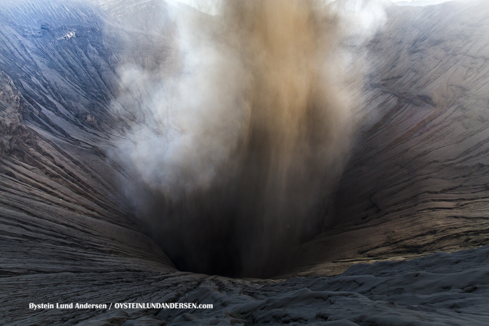
Photo : Oystein Lund Andersen ( 2016).
Mexico , Colima :
Weekly technical bulletin of the Colima Volcano activity
Date: 19 July 2019 Bulletin No. 130
Seismic activity:
During the last week, it was automatically registered:
23 high frequency events (HF),
3 events of long period type (LP),
7 landslides,
2 low intensity explosions
8.5 min of low amplitude tremor.
Four lahares were also recorded in the Montegrande ravine.
Visual observations:
During the reporting period, small explosions and intermittent releases of steam and gas mainly from the northeast side of the crater continue to be recorded. The visibility of this week allowed to observe the volcano on very little time. It was also possible to observe, with the help of surveillance cameras, the lahars that descended into the ravine of Montegrande. When cloudiness allowed, the fixed thermal camera located south of the volcano detected thermal anomalies associated with the smoking activity during the last week.
Geochemistry:
No SO2 flow measurements were performed during the last week.
Remote perception:
No thermal anomalies detected by the MIROVA satellite system were observed during the last week.
Diagnostic:
The volcano maintains an explosive activity of low intensity. The occurrence of these events indicates that the gas associated with the moving magma has reached superficial levels. This activity can continue and increase in intensity over the next few days or weeks. The staff in charge of monitoring the volcano is attentive to possible changes and changes in activity.
Source : UCOL
Photo : Protección Civil Jalisco