Novembre 24 , 2018.
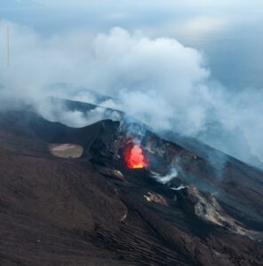
Iceland , Grímsvötn :
The third major volcano of Vatnajökull stirs: Sharp tremors in Grímsvötn volcano.
Vatnajökull glacier, the largest glacier in Iceland and Europe, hides five or six active volcanoes. In addition to Bárðarbunga and Öræfajökull, which have been showing signs of growing activity in recent months and years, the ice cap hides Esjufjöll and Kverkfjöll, which are relatively inactive, as well as Grímsvötn, and the connected volcano Þórðarhyrna. Grímsvötn is the single most active volcano in Iceland, having erupted more than 60 times since the 13th century.
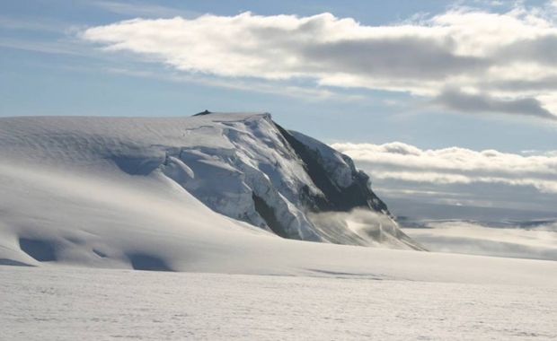
The rim of the volcano’s caldera juts above the ice cap of Vatnajökull.
Grímsvötn reminded us that it is still very active early morning, with a sharp earthquake swarm shortly before 6 am.
A 3.2 magnitude quake was recorded at 5:41 am with an epicenter at a depth of 1.2 km (0.75 mi) 2.2 km (1.4 mi) northeast of Grímsfjall peak, one of the peaks of the volcano’s caldera. The quake was followed by a second smaller tremor. The quakes do not suggest immediate volcanic activity, but serve as a reminder that while all eyes remain fixed on the monster Katla, hidden beneath Mýrdalsjökull, or the deadly Öræfajökull and very active Bárðarbunga, any of the dozens of active volcanoes of Iceland can wake up at any time.
The main threat posed by an eruption in Grímsvötn are outburst floods which can damage or destroy roads and bridges in their way. These floods find their way out to the sandar, the glacial outwash plains south of Vatnajökull.
Source : icelandmag.is.
Photo : ICE-SAR
Russia / Kuriles Islands , Sarychev Peak :
VOLCANO OBSERVATORY NOTICE FOR AVIATION (VONA).
Issued: November 22 , 2018 .
Volcano:Sarychev Peak (CAVW #290240)
Current aviation colour code:GREEN
Previous aviation colour code:yellow
Source:KVERT
Notice Number:2018-112
Volcano Location:N 48 deg 5 min E 153 deg 12 min
Area:Central Kuriles, Russia
Summit Elevation:4906.88 ft (1496 m)
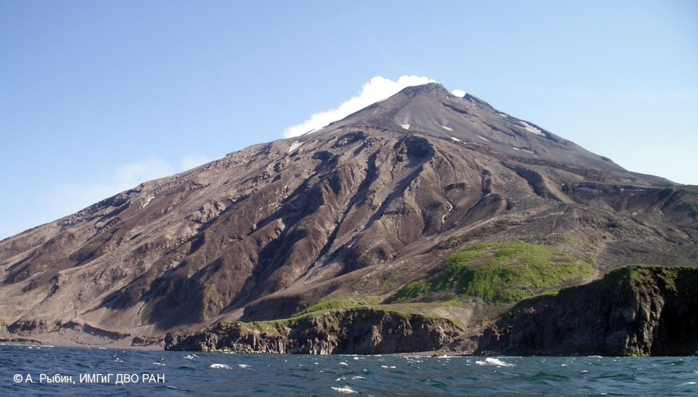
A state of Peak Sarychev volcano after a strong eruption on June 12-15, 2009: pyroclastic deposits covered all volcanic flanks.
Volcanic Activity Summary:
A moderate gas-steam activity of the volcano continues. According to satellite data, a thermal anomaly over the volcano was noted last time on 15 October, 2018, and ash explosions – on 10 October, 2018. The volcano was quiet or obscured by clouds from 16 October to the present. KVERT continues to monitor Sarychev Peak volcano.
A moderate gas-steam activity of the volcano continues. The danger of ash explosions up to 13,100-19,700 ft (4-6 km) a.s.l. is remain. Ongoing activity could affect low-flying aircraft.
Volcanic cloud height:NO ASH CLOUD PRODUSED
Other volcanic cloud information:NO ASH CLOUD PRODUSED.
NOTE: The Kvert lowers the aviation alert level from Yellow to GREEN.
Source : Kvert.
Photo : A. Rybin, IMGG FEB RAS.
Colombia , Nevado del Huila :
Subject: Weekly activity bulletin of the Nevado del Huila volcano
The level of activity of the volcano continues at : Yellow activity level or (III): changes in the behavior of volcanic activity.
According to the analysis and evaluation of the information obtained through the surveillance network of the Nevado del Huila volcano, from November 13 to 19, 2018, the COLOMBIAN GEOLOGICAL SERVICE – Volcanological and Seismological Observatory of Popayán indicates that:
• During the evaluated period, 341 seismic events were recorded, 148 related to rock fracturing processes (type VT) and 193 to fluid dynamics in volcanic canals. Of these 184 were classified as long-period events (LP type), four (4) were related to both fracture mechanisms and fluid dynamics; they were therefore classified as hybrid types (HB type) and five as tremor pulses. (TR type), low energy level.

• The images obtained during the week by the web cameras of Caloto, Tafxnú, Maravillas and La Palma showed very low levels of degassing of the volcanic system.
Therefore, it is concluded that the volcano exhibited stable behavior during the evaluated period. The Colombian geological service is attentive to the evolution of the volcanic phenomenon and will inform in good time on the changes which could occur
Source : SGC.
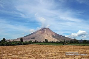
Guatemala , Fuego :
VOLCANOLOGICAL SPECIAL BULLETIN BEFGO N ° 220-2018, ACTIVITY INCREASE. Guatemala 23 November 2018 at 7:00 am (local time).
In the last few hours, the Fuego volcano has shown slight increases in activity, mainly due to its explosive activity. So far, there have been moderate explosions ranging from 15 to 18 per hour, raising columns of gray ash at altitudes between 4500 and 4800 m above sea level, dispersing over a distance of about 20 kilometers, directed West, Southwest and South. The explosions generate low to moderate rumblings with degassing sounds in intervals of between 3 and 8 minutes, generating weak shock waves.
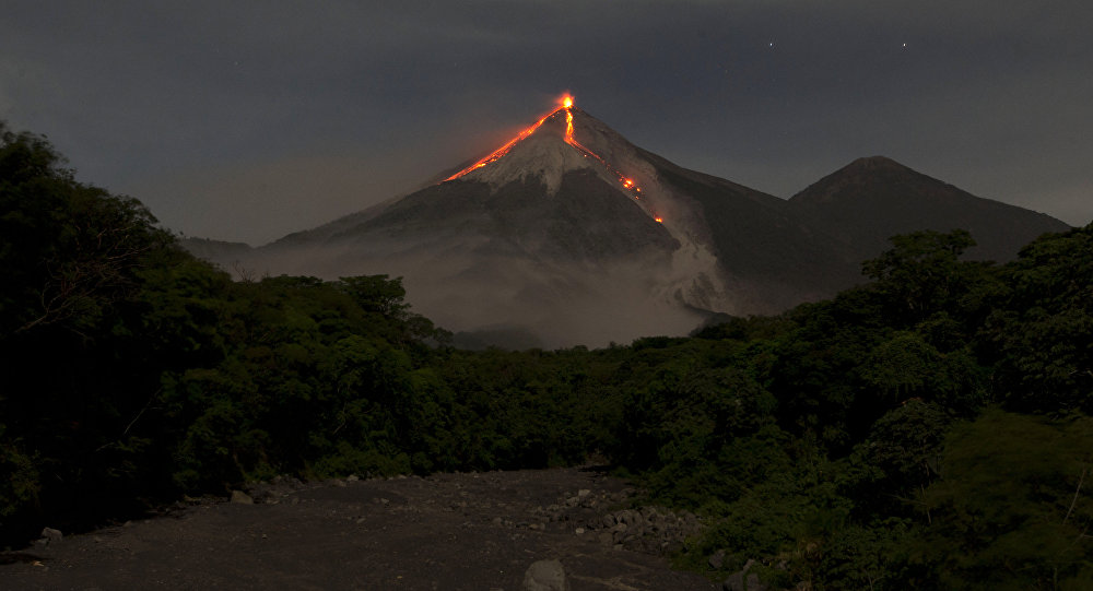
Due to the presence of loose materials that persist in the ravines, a remnant of the last eruption, and the generation of avalanches around the crater that descend towards the main ravines, it is observed in the volcanic perimeter a resuspension of fine materials. This activity also generated ash falls in the communities of Panimache I and II, Morelia, Santa Sofia, El Porvenir, Finca Palo Verde, Sangre de Cristo, Yepocapa and others located in this direction.
Source : Insivumeh.
Photo : Moises Castillo / Sputnik.
Indonesia , Anak Krakatau :
VOLCANO OBSERVATORY NOTICE FOR AVIATION – VONA.
Issued: November 23 , 2018
Volcano: Anak Krakatau (262000)
Current Aviation Colour Code: ORANGE
Previous Aviation Colour Code: orange
Source: Anak Krakatau Volcano Observatory
Notice Number: 2018KRA86
Volcano Location: S 06 deg 06 min 07 sec E 105 deg 25 min 23 sec
Area: Lampung, Indonesia
Summit Elevation: 1082 FT (338 M)
Volcanic Activity Summary:
Eruption with ash clouds at 23:11 UTC (06:11 local time). The eruption lasted for 33 seconds.
Volcanic Cloud Height:
Best estimate of ash-cloud top is around 2042 FT (638 M) above sea level, may be higher than what can be observed clearly. Source of height data: ground observer.
Other Volcanic Cloud Information:
Ash-cloud moving to northeast.
Remarks:
Eruption recorded on seismogram with maximum amplitude 57 mm and maximum duration 33 second.
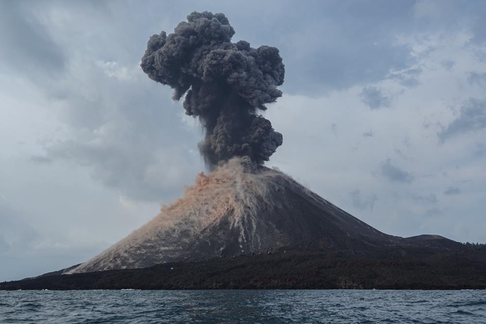
Activity Level at level II (WASPADA). The volcano Krakatau (338 m) has developed its volcanic activity since June 18, 2018.
Since yesterday and until this morning, the volcano was covered with fog. The smoke from the crater was not observed. Low to moderate wind blows north and northeast.
The seismographs, on November 23, 2018, recorded:
1 earthquake emission
10 shallow volcanic earthquakes
10 deep volcanic earthquakes
A tremor is recorded continuously with an amplitude between 2 and 10 mm (dominant value 3 mm)
Recommendation: People / tourists are not allowed to approach the crater within 2 km.
Source : Magma Indonésie , PVMBG.
Photo : Martin Rietze .