November 24 , 2025.
New Zealand , White Island :
Minor volcanic activity continues at Whakaari/White Island characterised by weakly loaded ash and gas plumes that are dispersed downwind.
Volcanic Alert Level remains at 3 and Aviation Colour Code remains Orange.
Published: Mon Nov 24 2025 11:30 AM
Whakaari/White Island continues to generate weakly loaded volcanic ash plumes that are dispersed downwind. This activity has been continuing throughout November, punctuated by short-lived, more visible energetic plumes that last for several minutes and rise 1-3 km. Available observations indicate that the plumes contain a minor amount of fine volcanic ash particles. The Volcanic Alert Level remains at 3 and the Aviation Colour Code remains Orange.
Observations of Whakaari/White Island since our last Volcanic Activity Bulletin (2025/17) indicate that minor eruptive activity is ongoing. This is characterised by passive weak ash emissions (see image below) associated with the dominantly gas-rich plumes, interspersed by more energetic plumes that reach 1-3 km above the island. The relatively high plumes have been enhanced by unstable atmospheric conditions, making them readily visible from the mainland.
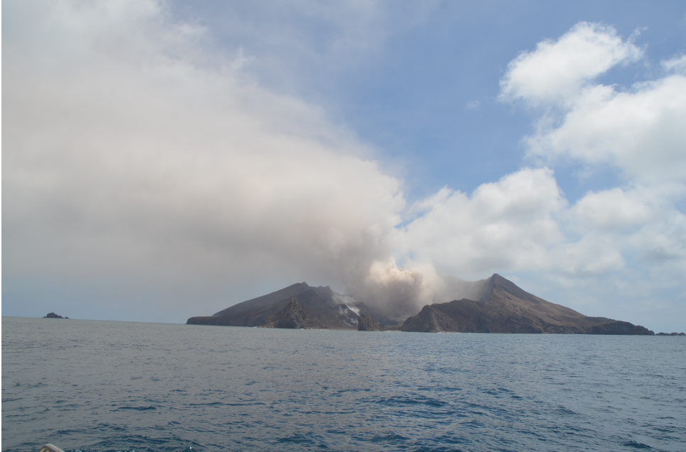
Image of Whakaari taken on Friday 21st November showing minor ash emissions.
Satellite data indicates that the plumes contain detectable fine volcanic ash and sulphur dioxide (SO2) gas, a common volcanic gas. Gas and fine particles in the plume may be swept onto the Bay of Plenty coastline, during favourable winds. Residents may notice this as sulphur odours.
There remains a very low likelihood of ash falling to the ground (ashfall) at the coast. The level of volcanic activity would have to escalate significantly for this likelihood to increase.
Based on the recent observations, the Volcanic Alert Level remains at level 3 (minor volcanic eruption) and the Aviation Colour Code remains Orange. These levels acknowledge the predominant low level of activity but also reflect the degree of uncertainty due to the lack of sensors on the island to provide real-time monitoring. Earth Sciences NZ Volcano Monitoring Group and National Geohazards Monitoring Centre will continue to closely monitor Whakaari/White Island for any changes in activity. Without sensors on the island, our monitoring continues to rely on remote cameras, satellite imagery, and periodic observation and gas flights to monitor Whakaari/White Island. We will provide further updates when information becomes available.
Source : Geonet / Geoff Kilgour / Duty Volcanologist
Photo : Brad Scott (ESNZ).
Philippines , Kanlaon :
KANLAON VOLCANO LAHAR ADVISORY , 24 November 2025 ,2:00 PM
Based on the Philippine Atmospheric Geophysical and Astronomical Services Administration (PAGASA) Tropical Cyclone Bulletin No. 3 and Weather Advisory #18 issued at 11:00AM today, 24 November 2025, Tropical Cyclone “Verbena” and the shear line will potentially bring heavy to intense rainfall over several areas of Central Philippines, including Negros Island, in the coming days. This can generate volcanic sediment flows or lahars, sediment-laden streamflows or muddy run-off and related siltation in rivers and drainage areas on Kanlaon Volcano, which is currently at Alert Level 2. DOST-PHIVOLCS thus strongly recommends increased vigilance and readiness of communities in pre-determined zones of lahar and related hazards on this volcano.
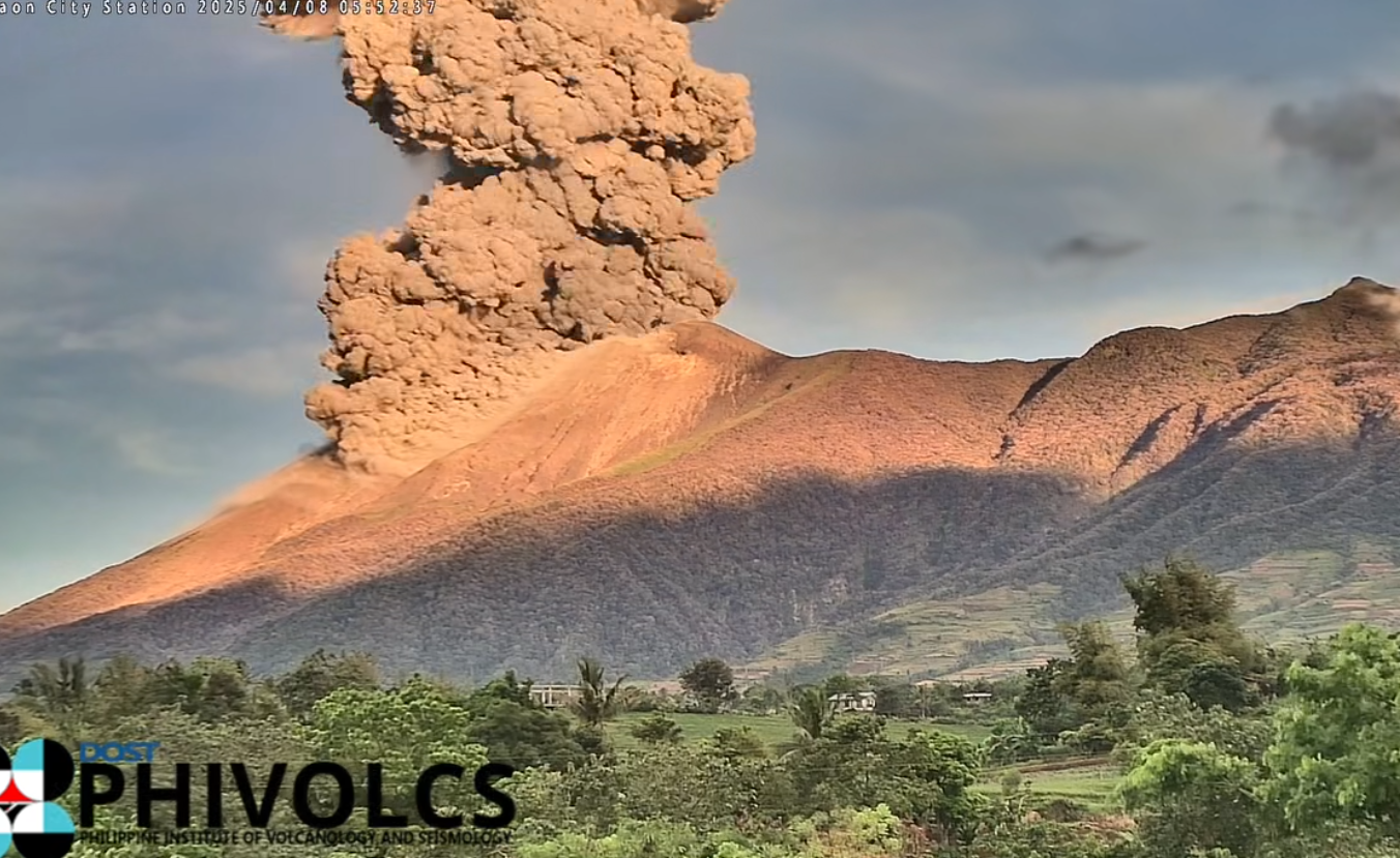
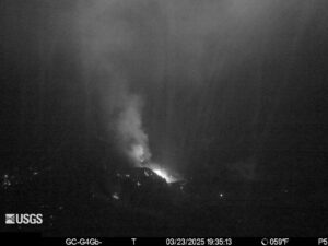
Prolonged heavy to intense rainfall may generate life-threatening lahars and sediment-laden streamflows on major channels draining the southern, western and eastern slopes of Kanlaon Volcano. Post-eruption lahars can be generated by intense rainfall eroding loose material from remnant pyroclastic density current (PDC) deposits of the 24 October 2025 explosive eruption and loose ashfall from this as well as from recent ash emission events. In addition, non-eruption lahars can be generated when areas on the upper slopes that have been recently exposed by landslides or weakened during the passage of Supertyphoon Tino earlier this month become susceptible to failure and feed debris to rivers that have already delivered destructive flows to downstream communities. Communities of Bago City, La Carlota City, La Castellana, Moises Padilla and San Carlos City, Negros Occidental and Canlaon City, Negros Oriental that are situated along the following channels may be affected by lahars and sediment-laden streamflows and related flooding and siltation:
These communities as well as those further downstream of the above channels are advised to be prepared in case evacuation becomes necessary and to avoid traversing affected streams even those farther downslope of the volcano. Kanlaon lahars, which were shown by Supertyphoon Tino to be strong enough to transport enormous volumes of gravel and boulders, could threaten communities by their force of impact, inundation, burial and wash out.
DOST-PHIVOLCS strongly advises the communities and local government units of the above identified areas of risk to continually monitor the rainfall conditions and take pre-emptive response measures for their safety.
Source et photo : DOST-PHIVOLCS
Ethiopia , Afar Region ( Hayli Gubbi , Erta Ale ?) :
Ethiopia: Rare Explosive Eruption in the Afar Region
A few hours ago, an intense explosive eruption occurred in central Ethiopia, a tectonically very active region home to numerous volcanic systems. Satellite images appear to indicate that the eruption took place in the Hayli Gubbi area, a (relatively unknown) shield volcano located south of the more famous Erta Ale.
At present, very little is known about this eruption. Satellite data indicates that the eruptive column reached an altitude of at least 14 km, as later confirmed by the VAAC. In a short time, the plume of ash and gas was carried by the winds as far as Yemen and southern Saudi Arabia. The few eyewitness accounts gathered on the ground suggest a paroxysmal eruption accompanied by loud detonations and significant ashfall, which also affected some surrounding villages.
The eruptive history of Hayli Gubbi is unknown. Evidence of activity dating back to the Holocene (the last 12,000 years), based on its morphology and lava flows covering recent deposits, exists, but there is no precise estimate of the date of the last eruption. With all due caution, the current eruption could be the first in its history! Its reactivation may have begun in July, when a significant deep magmatic intrusion was detected nearby. It cannot be ruled out that this new dike of primitive magma destabilized an older, colder, and crystallized magma reservoir, thus triggering this unexpected explosive eruption.
Conflicting Reports
Different sources refer to different volcanoes. While some reports attribute the eruption to Ale-Bagu (also known as Ali Bagu, Amaytole, or Ummuna), the official VAAC statement identifies the volcano as Hayli Gubbi. The two volcanoes are located in the Erta Ale volcanic chain in the Danakil Desert, with Hayli Gubbi being the southernmost volcano in the chain. The confusion may stem from the region’s extreme remoteness and the presence of several volcanoes in close proximity.
Hayli Gubbi is the southernmost volcano in the Erta Ale chain. Recent tectonic activity has created a graben at its summit. A symmetrical cinder cone, containing a 200-meter-diameter crater with fumarolic activity, occupies the center of the graben. An ancient shield volcano is covered to the north by recent lava flows fed by fissures. Lava flows from the axial part of a southward-extending fissure system have reached the floor of the Giulietti Plain, covering 8,200-year-old sedimentary deposits. The open fissures extend for more than 10 km and are bordered by dozens of small ejecta cones and collapse craters.
Sources : Il mondo dei terremoti , GVP , Vulkane.net
Photo : Idris Hummed.
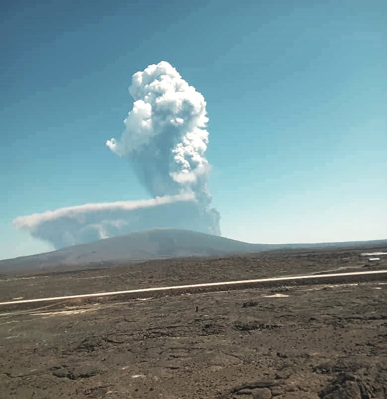
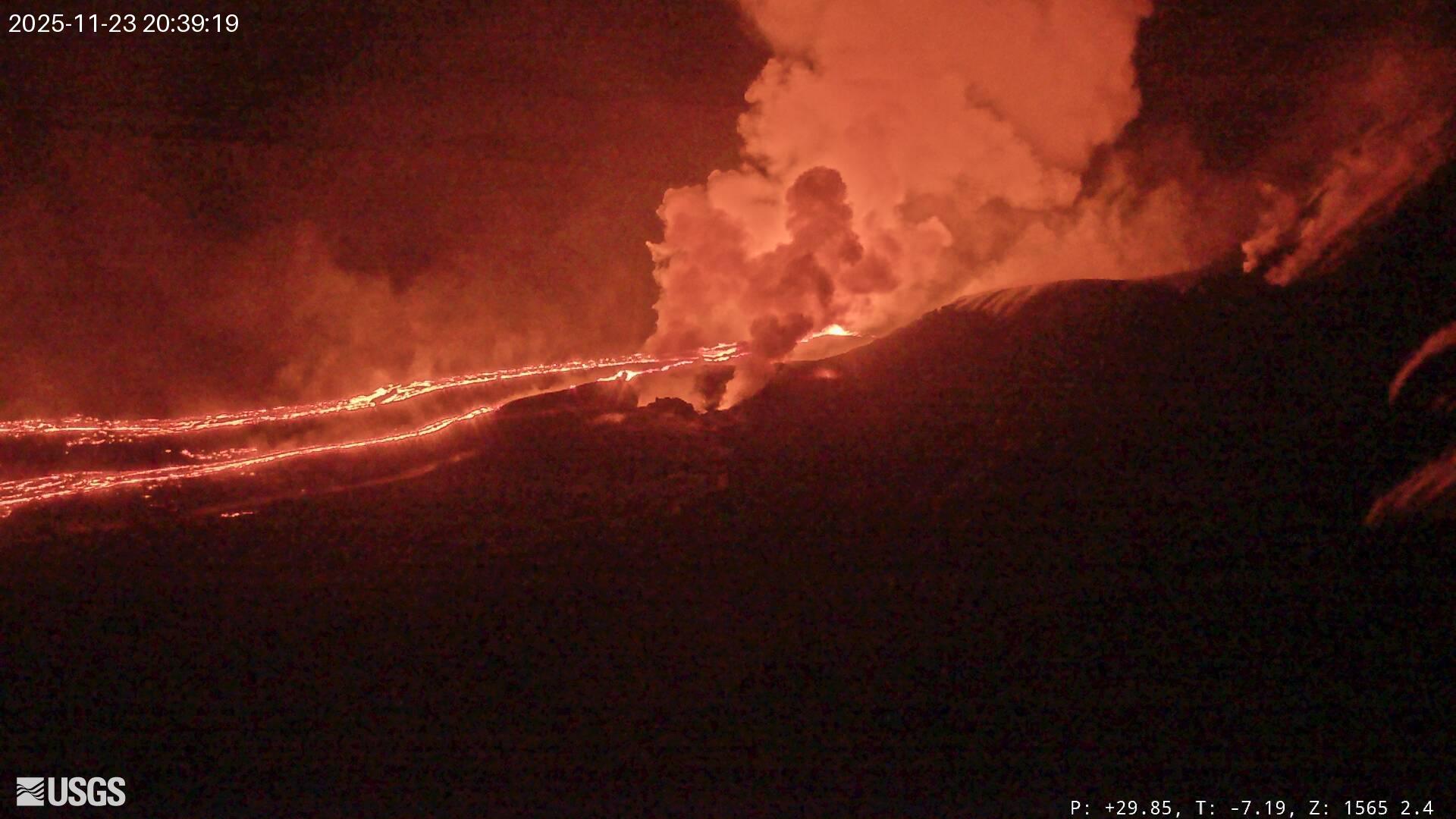
Hawaii , Kilauea :
HAWAIIAN VOLCANO OBSERVATORY DAILY UPDATE , U.S. Geological Survey
Sunday, November 23, 2025, 9:33 AM HST (Sunday, November 23, 2025, 19:33 UTC)
19°25’16 » N 155°17’13 » W,
Summit Elevation 4091 ft (1247 m)
Current Volcano Alert Level: WATCH
Current Aviation Color Code: ORANGE
Activity Summary:
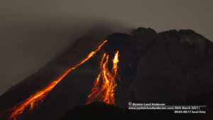
Periodic overflows continue from the south vent. Overnight flows were longer in duration than those seen during the daytime and included low dome fountains. Inflationary tilt continues to be recorded by summit tiltmeters. We are currently in the forecast window for episode 37. Models suggest that episode 37 may occur between today and November 26, with the highest probability between today, November 23, and Tuesday, November 25.
Summit Observations:
Periodic overflows continued from the south vent yesterday and overnight. During the daytime yesterday, overflows were frequent, approximately every 15-45 minutes, and short-lived, lasting approximately 5-15 minutes each. Activity changed by 6:00 p.m. HST yesterday evening to less frequent, longer duration (50-70 minutes) overflows that each produced dome fountains of 5-10 meters (15-30 feet) in height. Each of these dome fountain overflows was associated with a minor increase in seismic intensity (RSAM) and coincident decrease in tilt. There have been 58 overflows from the summit vents since overflows began on Friday at 9:30 a.m. HST. Overflows alternated between the vents on Friday but have been largely from the south vent since Friday evening. Small tremor bursts associated with lava drain back continue to be recorded along with low to moderate seismic tremor.
Inflation continues at the summit, but slowly. UWD recorded less than 1 microradian of inflationary tilt in the past 24 hours for a total of 21.4 microradians recorded since the end of episode 36 on November 9.
Plumes of gas are visible from both the south and north vents, and sulfur dioxide (SO2) gas emissions remain at eruption pause levels, typically between 1,200 and 1,500 tonnes per day.
Source et photo : HVO.
Ecuador , El Reventador :
REVENTADOR VOLCANO DAILY STATE REPORT, Sunday, November 23, 2025.
Information Geophysical Institute – EPN.
Surface Activity Level: High, Surface Trend: No Change
Internal Activity Level: Moderate, Internal Trend: No Change
From November 22, 2025, 11:00 AM to November 23, 2025, 11:00 AM:
Seismicity:
Below is the count of seismic events recorded at the reference station.
Explosion (EXP) 92
Long Period (LP) 15
Emission Tremor (TREMI) 10
Harmonic Tremor (TRARM) 16

Rainfall/Lahars:
Rainfall has been recorded in the volcano area, but it has not generated any mudflows or debris flows. **In the event of heavy rainfall, accumulated material could be remobilized, causing mudflows and debris flows that would cascade down the volcano’s flanks and flow into nearby rivers.**
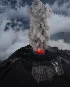
Emission Column/Ash:
Due to weather conditions in the volcano area, it was not possible to observe any gas and/or ash emissions through the monitoring camera system. However, several gas and ash emissions were recorded by the GOES-19 satellite system, reaching altitudes between 800 and 1,000 meters above the crater and drifting toward the Northwest and West-Northwest. Furthermore, the Washington VAAC agency issued three reports indicating ash emissions reaching altitudes of 1,300 meters above the crater and drifting west-northwest and northwest.
Other monitoring parameters:
Over the past 24 hours, the FIRMS satellite system recorded 23 thermal anomalies, while the MIROVA-VIIRS system recorded 7 and the MIROVA-MODIS system 1.
Note:
From yesterday afternoon until the time of writing, the volcano remained mostly cloud-covered.
Alert Level – SGR: Orange
Source : IGEPN
Photo : E. Telenchana/IG-EPN