November 5 , 2025.
Italy / Sicily , Etna :
MONTHLY BULLETIN, OCTOBER 2025. (Publication date: 04/11/2025)
ACTIVITY SUMMARY
Based on monitoring data, the following points should be noted:
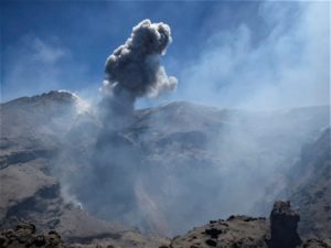
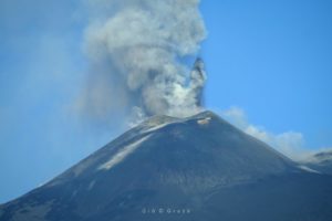
1) VOLCANOLOGICAL OBSERVATIONS: Variable degassing at the summit craters, with episodic ash emissions from the Bocca Nuova crater.
2) SEISMOLOGY: Moderate seismic activity due to fracturing. Volcanic tremor amplitude at an intermediate level.
3) INFRASOUND: Moderate infrasound activity, with sources located in the Northeast Crater (NEC) area and the Bocca Nuova Crater (BN) area.
4) GROUND DEFORMATION: Ground deformation monitoring networks have not detected any significant changes.
5) GEOCHEMISTRY: SO₂ fluxes rising toward an average level.
CO₂ fluxes from the ground (EtnaGas Network): low values.
Partial pressure of dissolved CO₂ in groundwater (EtnaWater Network): no update.
Helium isotope ratio at peripheral sites: the latest data, dated October 7, indicates a high value.
6) SATELLITE OBSERVATIONS: Over the past month, thermal activity observed by satellite in the summit area has been generally low.
VOLCANOLOGICAL OBSERVATIONS
During the week, Etna’s volcanic activity was monitored through analysis of images from the INGV – Osservatorio Etneo (INGV-OE) surveillance cameras and through direct observations conducted on the ground by INGV-OE staff on October 29. Surveillance camera observations were irregular due to adverse weather conditions affecting the summit area.
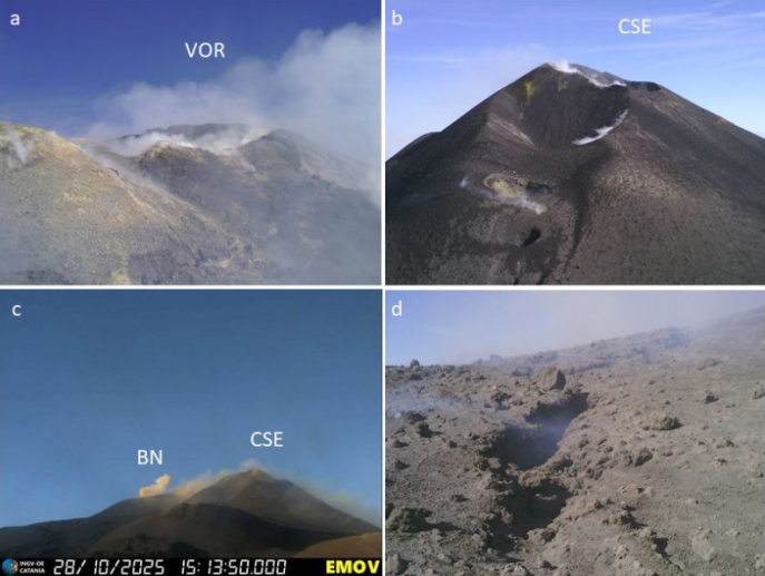
Fig. 3.2 a) Degassing from fumaroles at the rim of the VOR crater; b) Degassing from fumaroles at the rim of the crater and from a vent located on the central-western flank of the CSE; c) Ash emission from BN; d) Detail of the fracture field observed in BN2. (a), (b), and (d) Images recorded during the campaign of October 29; (c) Image recorded by the camera installed at La Montagnola (view from the south).
On days with good visibility, it was possible to observe that the summit craters were affected by degassing of varying intensity and speed. In particular, based on surveillance camera images and an inspection carried out by INGV-OE staff on October 29, fumarolic degassing was observed along the rim of Voragine Crater (VOR; Fig. 3.2a), continuous degassing from fumaroles along the crater rim and from a vent located on the central-western flank of the southeastern crater (CSE; Fig. 3.2b), and pulsatile degassing with rumbling sounds and episodic, weak ash emissions, which rapidly dispersed into the atmosphere, from Bocca Nuova Crater starting on October 24 (BN; Fig. 3.2c). More specifically, vent BN1 produced continuous pulsatile degassing and ash emissions, while the second vent, BN2, was characterized by continuous and extensive degassing. Furthermore, during the study, the presence of cold concentric fracture fields was detected in both BN vents (Fig. 3.2d). Finally, the northeast crater (CNE) also produced degassing of varying intensity.
Source : INGV
Photos : Fabrizio Zuccarello ( capture d’écran / FB) , INGV.
Italy , Stromboli :
ACTIVITY SUMMARY
Based on monitoring data, the following points should be noted:
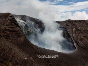
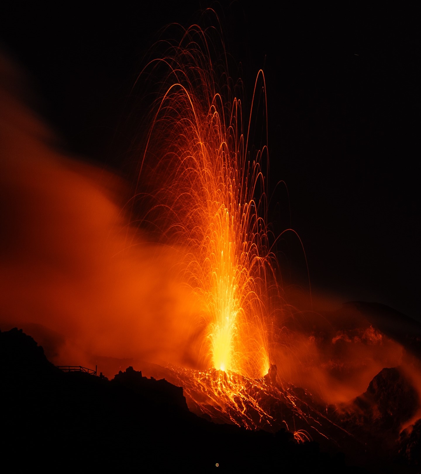
1) VOLCANOLOGICAL OBSERVATIONS: During this period, typical Strombolian-type eruptive activity was observed. The total hourly frequency fluctuated between average (12 events/h) and high (20 events/h). The intensity of the explosions was mainly low in the North Crater area and low to medium in the Central-South Crater area.
2) SEISMOLOGY: The monitored seismic parameters showed no significant variations.
NOTE: This bulletin is based on data acquired from a maximum of 8 stations.
3) GROUND DEFORMATION: The permanent GNSS ground deformation monitoring network showed no significant variations.
4) GEOCHEMISTRY: SO₂ fluxes were at an average level. CO₂ flux from the ground in the Pizzo area (STR02) at average values.
C/S ratio in the pen: no update.
The dissolved helium isotope ratio (R/Ra) in the thermal aquifer is high. CO₂ flux from the ground in the San Bartolo area: average to high values.
CO₂ flux from the ground in the Scari area: high values.
5) SATELLITE OBSERVATIONS: Satellite-observed thermal activity in the summit area was generally low, with a few isolated thermal anomalies of moderate intensity.
VOLCANOLOGICAL OBSERVATIONS
During the observation period, Stromboli’s eruptive activity was characterized by analyzing images recorded by the INGV-OE monitoring cameras located at 190 m (SCT-SCV) and at Punta dei Corvi (SPCT). Explosive activity was primarily produced by five eruptive vents located in the North Crater area and by at least two vents located in the Central-South area.
Observations of explosive activity captured by the monitoring cameras
Five active vents were observed in the North Crater area (N), two in sector N1, and three in sector N2. These produced explosive activity of low intensity (less than 80 m high) and sometimes of medium intensity (less than 150 m high). The eruptive products were mainly composed of coarse materials (bombs and lapilli). The average frequency of explosions ranged from 12 to 17 events per hour. In the Central-South (CS) crater area, two main vents were observed, exhibiting explosions of fine material mixed with coarse material and explosions of coarse material of low to medium intensity, respectively. The average frequency of explosions ranged from zero to six events per hour.
Source : INGV
Photo : Stromboli stati d’animo / Sebastiano Cannavo .
Alaska , Atka volcanic complex :
AVO/USGS Volcanic Activity Notice
Current Volcano Alert Level: NORMAL
Previous Volcano Alert Level: ADVISORY
Current Aviation Color Code: GREEN
Previous Aviation Color Code: YELLOW
Issued: Tuesday, November 4, 2025, 11:55 AM AKST
Source: Alaska Volcano Observatory
Notice Number: 2025/A672
Location: N 52 deg 19 min W 174 deg 8 min
Elevation: 5030 ft (1533 m)
Area: Aleutians
Volcanic Activity Summary:
No volcanic activity has been detected at the Atka volcanic complex since the small explosion at 21:27 AKDT on October 29, 2025 (05:27 UTC October 30, 2025). The Aviation Color Code and Alert Level are being lowered to GREEN/NORMAL. Brief explosive events at Korovin Volcano can occur without significant precursory unrest. Fallout of ash is unlikely to extend much beyond the upper flanks of the volcano. Possible ash clouds generated by such events are expected to be small and dissipate quickly.
Remarks:
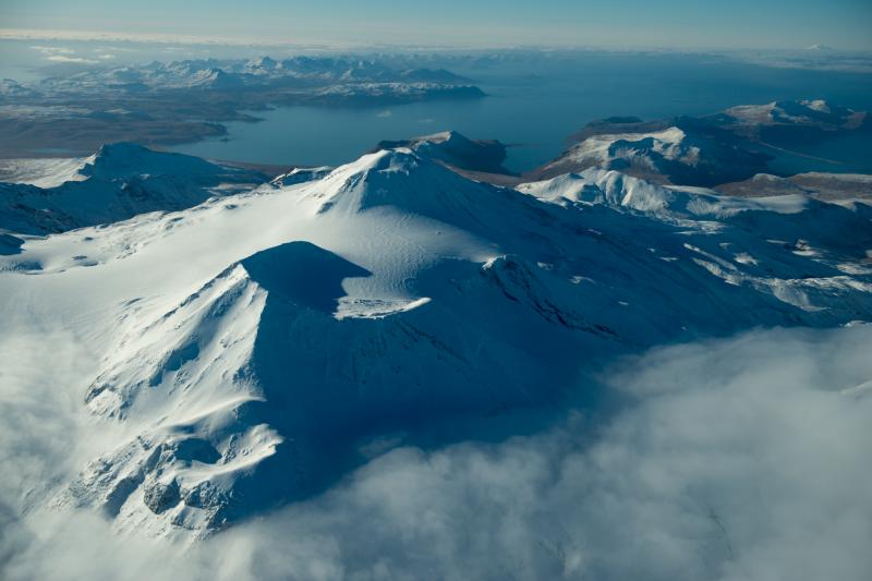
The Atka volcanic complex forms the northern part of Atka Island, located about 16 km north of the community of Atka and 1,761 km southwest of Anchorage. The Atka volcanic complex includes a possible older caldera and several younger vents, including Korovin Volcano, Mount Kliuchef, and Sarichef Volcano. Korovin Volcano, a 1553-m-high (5030 ft) stratovolcano, has been the site of most historical volcanic activity, and has a small, roiling crater lake that occasionally produces energetic steam emissions. Korovin has erupted several times in the past 200 years, including 1973, 1987, and 1998, and has likely had small ash emissions as recently as 2005. Typical recent Korovin eruptions produce minor amounts of ash and occasional but small lava flows. Reports of the height of the ash plume produced by the 1998 eruption ranged as high as 10,600 m (35,000 feet) above sea level. Mount Kliuchef is composed of a series of five vents aligned northeast–southwest. The two main summit vents of Kliuchef appear relatively young and the easternmost was probably the source of an 1812 eruption that is sometimes attributed to Sarichef.
Source : AVO.
Photo : Clifford, Roger ( Atka Island ).
Chile , Laguna del Maule :
Special Volcanic Activity Report (REAV), Maule Region, Laguna del Maule Volcanic Complex, November 5, 2025, 12:15 PM local time (Continental Chile)
The Chilean National Geology and Mining Service (Sernageomin) announces the following PRELIMINARY information, obtained through the monitoring equipment of the National Volcanic Monitoring Network (RNVV), processed and analyzed at the Southern Andean Volcano Observatory (OVDAS):
On Wednesday, November 5, 2025, at 2:23 AM (5:23 AM UTC), monitoring stations installed near the Laguna del Maule volcanic complex recorded activity associated with rock fracturing within the volcanic system.
The characteristics of the highest-energy earthquake after analysis are as follows:
TIME OF ORIGIN: 02:23 local time (05:23 UTC)
LATITUDE: 36.066° S
LONGITUDE: 70.490° W
DEEP: 7.9 km
LOCAL MAGNITUDE: 3.8 (ML)
Observation:
Recurring seismic activity is observed at the Laguna del Maule volcanic complex, with lower-energy volcano-tectonic (VT) events continuing.
The volcanic technical alert remains at YELLOW.
Source : Sernageomin
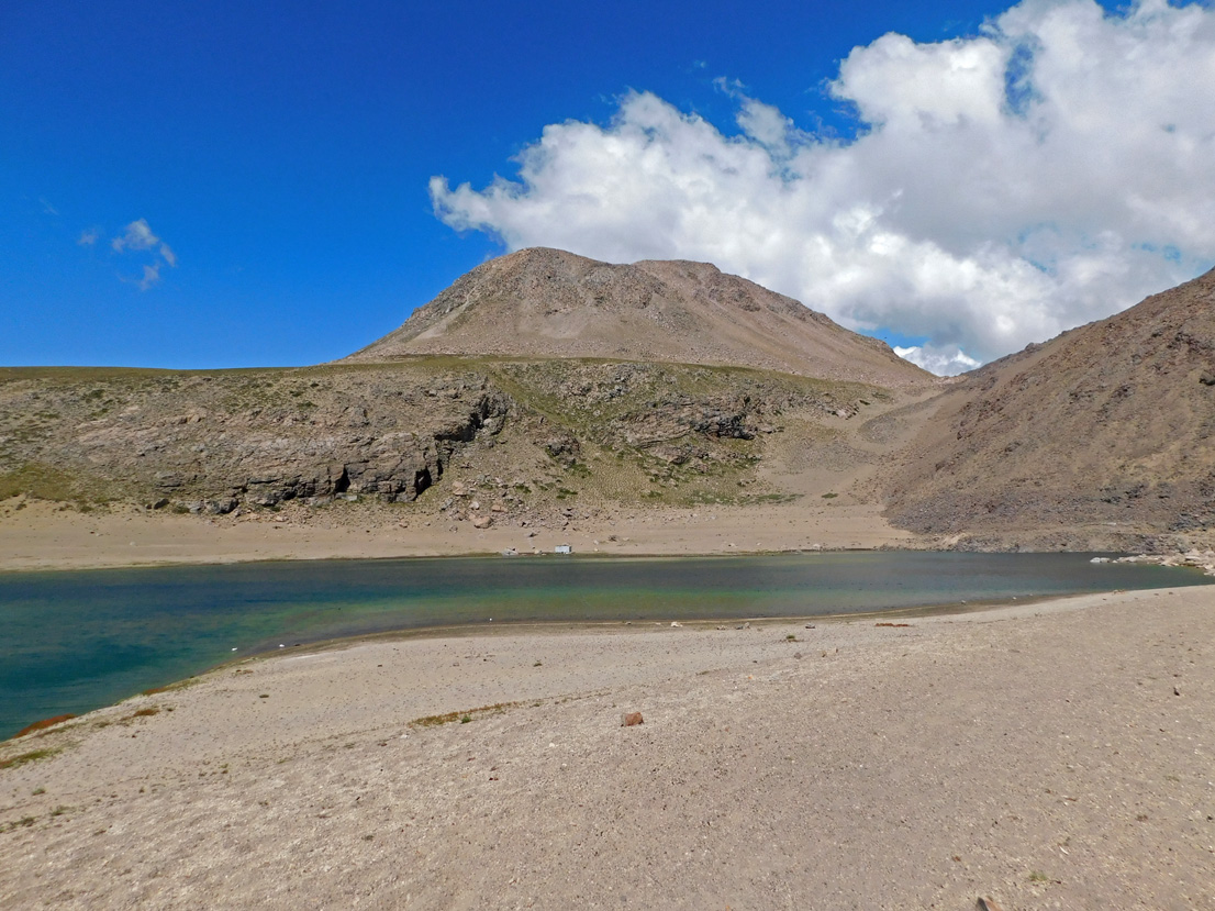
Photo : Álvaro Vivanco , Photo prise au Sud-Ouest de la lagune de Maule.
Colombia , Nevado del Ruiz :
Manizales, November 4, 2025, 7:20 PM
Regarding the monitoring of activity at the Nevado del Ruiz volcano, the Colombian Geological Survey (SGC), an agency under the Ministry of Mines and Energy, reports that:
During the week of October 28 to November 3, 2025, the volcano continued to exhibit unstable behavior. The main variations in monitored parameters, compared to the previous week, are as follows:
– Seismic activity associated with rock fracturing processes within the volcanic edifice decreased in the number of recorded earthquakes, while the seismic energy released remained stable. Seismicity was primarily located on the west-southwest and north-northwest flanks, at average distances of 5 km and 3 km respectively from the Arenas crater and at depths between 4 km and 7 km below the summit. Lesser seismic activity also occurred within the crater at depths of less than 2 km, and sporadically on the other flanks of the volcano. The strongest earthquake of the week, with a magnitude of 3.1, was recorded on October 29 at 5:17 a.m., 5 km to the west-southwest and at a depth of 5 km. This event occurred during a surge in seismic activity in the aforementioned area. Additionally, on October 31, seismic activity related to the lava dome (protuberance or mound) located at the bottom of the crater was recorded, characterized by low seismic energy.
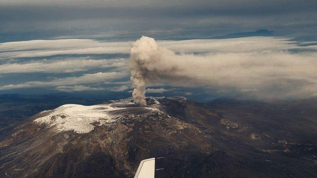
– Seismic activity associated with fluid dynamics in the volcanic conduits decreased, both in the number of recorded earthquakes and in the seismic energy released. The energy of these events was mostly low to moderate. Several pulsatile ash emissions were confirmed by conventional and thermographic cameras used to monitor the volcano, as well as by reports from officials at Los Nevados National Natural Park (PNNN). Variations in the apparent temperature of the emitted materials, associated with some of these ash emissions, were also observed.
The volcano continued to emit water vapor and volcanic gases, primarily sulfur dioxide (SO₂), into the atmosphere from the Arenas crater. The estimated SO₂ flux associated with degassing processes was variable and increased compared to the previous week. This increase was also visible in supplementary satellite imagery.
The column of gas, water vapor, or ash remained below 500 m above the volcano’s summit for most of the time. On October 31, during the ash emission recorded at 5:22 PM, it reached a maximum height of 1,500 m and a dispersion of 2,200 m. Regarding the direction of dispersion, the column was primarily directed towards the northwest and west-northwest flanks of the volcanic structure, generating ashfall on the morning of October 28 in the Valley of the Tombs, within the National Park of the North Noon (PNNN).
– During the monitoring of thermal anomalies at the bottom of the Arenas crater, via satellite platforms, low-energy anomalies were detected,
despite the high and persistent cloud cover in the region.
Source : SGC.
Photo : via Vulcaniya / FB.