October 9 , 2025.
Indonesia , Ibu :
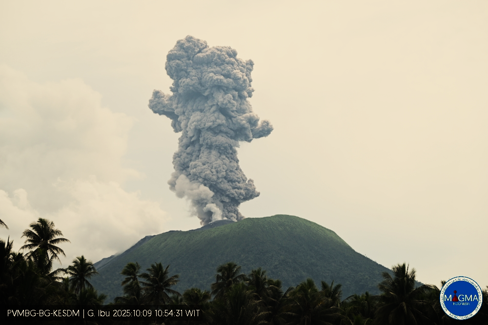
Mount Ibu erupted on Thursday, October 9, 2025, at 10:54 a.m. (local time). An ash column was observed about 2,000 m above the summit (about 3,325 m above sea level). The ash column was gray and of strong intensity, oriented northeast. This eruption was recorded by seismograph with a maximum amplitude of 28 mm and a duration of 110 seconds.
VOLCANO OBSERVATORY NOTICE FOR AVIATION – VONA
Issued : October 9 , 2025
Volcano : Ibu (268030)
Current Aviation Colour Code : ORANGE
Previous Aviation Colour Code : orange
Source : Ibu Volcano Observatory
Notice Number : 2025IBU1076
Volcano Location : N 01 deg 29 min 17 sec E 127 deg 37 min 48 sec
Area : North Maluku, Indonesia
Summit Elevation : 4240 FT (1325 M)
Volcanic Activity Summary :
Eruption with volcanic ash cloud at 01h54 UTC (10h54 local).
Volcanic Cloud Height :
Best estimate of ash-cloud top is around 10640 FT (3325 M) above sea level or 6400 FT (2000 M) above summit. May be higher than what can be observed clearly. Source of height data: ground observer.
Other Volcanic Cloud Information :
Ash cloud moving to northeast. Volcanic ash is observed to be gray. The intensity of volcanic ash is observed to be thick.
Remarks :
Eruption recorded on seismogram with maximum amplitude 28 mm and maximum duration 110 second.
Source et photo : Magma Indonésie .
Japan , Suwanosejima :
The Japan Meteorological Agency (JMA) reported that eruptive activity at Suwanosejima’s Ontake Crater continued during 22-29 September. Incandescence was observed nightly in webcam images. Eruptive events during 23-28 September generated ash plumes that rose 1-1.6 km above the crater rim and drifted mainly N, NW, and E. Small amounts of ashfall were reported in Toshima Village (3.5 km SSW) on 27 September. Ash emissions were continuous from 2238 on 27 September to 0100 on 28 September. The Alert Level remained at 2 (the second level on a five-level scale) and the public was warned to be cautious within 1.5 km of the crater.
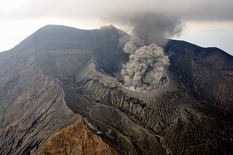
The 8-km-long island of Suwanosejima in the northern Ryukyu Islands consists of an andesitic stratovolcano with two active summit craters. The summit is truncated by a large breached crater extending to the sea on the E flank that was formed by edifice collapse. One of Japan’s most frequently active volcanoes, it was in a state of intermittent Strombolian activity from Otake, the NE summit crater, between 1949 and 1996, after which periods of inactivity lengthened. The largest recorded eruption took place in 1813-14, when thick scoria deposits covered residential areas, and the SW crater produced two lava flows that reached the western coast. At the end of the eruption the summit of Otake collapsed, forming a large debris avalanche and creating an open collapse scarp extending to the eastern coast. The island remained uninhabited for about 70 years after the 1813-1814 eruption. Lava flows reached the eastern coast of the island in 1884. Only about 50 people live on the island.
Due to the U.S. government shutdown, U.S. Geological Survey support for providing the weekly volcanic activity report is unavailable after October 1. Reporting will resume when funding is authorized, but missed weeks will not be populated.
Sources :Japan Meteorological Agency (JMA) , GVP.
Photo : N. Geshi. Geological Survey of Japan, H.Seo
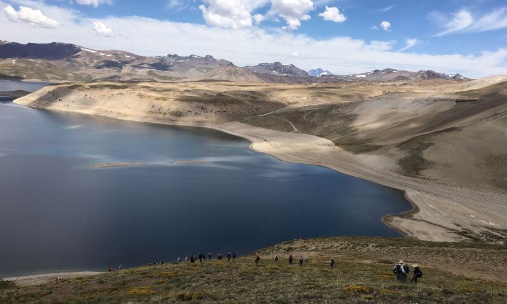
Chile , Laguna del Maule :
Special Report on Volcanic Activity (REAV), Maule Regions, Laguna del Maule Volcanic Complex, October 9, 2025, 1:45 a.m. local time (Continental Chile)
The National Geology and Mining Service of Chile (SERNAGEOMIN) announces the following preliminary information, obtained using the monitoring equipment of the National Volcanic Monitoring Network (RNVV), processed and analyzed at the Southern Andean Volcano Observatory (OVDAS):
On Thursday, October 9, 2025, at 1:27 a.m. (04:27 UTC), monitoring stations installed near the Laguna del Maule volcanic complex recorded an event associated with rock fracturing within the volcanic system.
The characteristics of the highest-energy earthquake after analysis are as follows:
TIME OF ORIGIN: 01:27 local time (04:27 UTC)
LATITUDE: 36.054° S
LONGITUDE: 70.475° W
DEPTH: 8.4 km
LOCAL MAGNITUDE: 4.0 (ML)
Observation:
The recurrent seismic activity observed in the Laguna del Maule volcanic complex, with volcano-tectonic (VT) events, continues at moderate to low levels, with no significant variations observed.
The technical volcanic alert remains at YELLOW.
Source : Sernageomin
Photo : auteur inconnu.
Chile , Planchón Peteroa :
Special Volcanic Activity Report (REAV)
October 8, 2025, 10:30 a.m. local time (Continental Chile)
The National Geology and Mining Service of Chile (Sernageomin) publishes the following information, obtained using the monitoring equipment of the National Volcanic Monitoring Network (RNVV), processed and analyzed at the Southern Andean Volcanological Observatory (OVDAS):
In recent days, a sustained increase in the external and internal activity of the Planchón Peteroa volcanic complex has been observed. Following the report published on Friday, October 3, surface activity has shown a progressive increase.
Consequently, on Monday, October 6, starting at 21:06 UTC, surveillance cameras installed near the complex recorded the emission of a column of gas and pyroclasts that reached approximately 1 km above the crater, maintaining similar characteristics until 22:50 UTC. This increase in surface activity was accompanied by an emission of 151 tonnes of sulphur dioxide (SO₂) according to satellite images (Mounts Project platform), the largest mass observed since the start of this cycle.
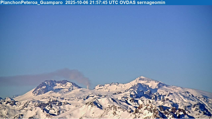
Image from the Guamparo surveillance camera, dated October 6, 2025, at 6:57 PM HL (9:57 PM UTC).
From a seismic perspective, signals associated with fluid dynamics persist at shallow depths, highlighting the presence of a tremor-like signal of deep origin. This recent phenomenon suggests the injection of new pulses of magmatic material from deeper areas, which would promote a greater response from the shallow hydrothermal system, consistent with the currently observed surface activity.
According to the latest volcanic activity reports published by SERNAGEOMIN for this system, and taking into account the above, the occurrence of new episodes of explosions of similar or greater energy, of low to moderate magnitude, likely to affect the immediate surroundings of the active craters, cannot be ruled out.
OBSERVATIONS:
As of the publication date of this report, seismic activity has not shown any further significant changes. The technical volcanic alert remains in effect at the YELLOW level.
Source et photo : Sernageomin.
Iceland , Hekla :
Geophysicists say the magma chamber beneath Hekla is steadily filling, raising questions about when Iceland’s most famous volcano might erupt again.
“The longer it takes between eruptions, the stronger the magma chamber under Hekla can become,” said Halldór Geirsson, professor of geophysics at the University of Iceland, when speaking to mbl.is.
A research team recently surveyed the mountain, measuring changes in its height and slope. Their calculations suggest magma is flowing into the chamber at around 250 litres per second. Halldór said it is possible the rupture threshold (aka; the point at which the chamber breaks and magma escapes) has shifted over time.
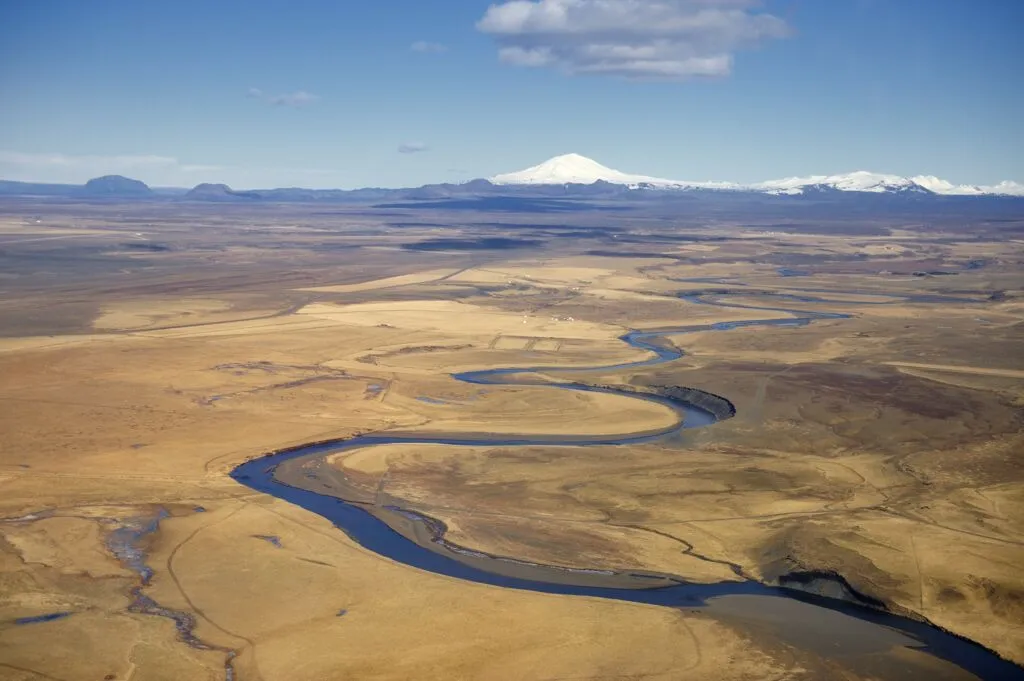
Ytri Rangá with Hekla in the background.
Surveying the slopes
“Hekla is now about twice as high as the expansion limit that triggered the eruption at the turn of the millennium,” he noted.
Similar land-slope measurements are being carried out at Askja, where the ground is also rising, indicating that an eruption in the Dyngjufjöll mountains could be possible.
Iceland’s volcanoes are closely monitored by the Icelandic Meteorological Office, the Institute of Earth Sciences, and international collaborators. Scientists share real-time data to assess likely volcanic activity and improve early-warning systems.
Source : Iceland Review
Photo : Ulrich Latzenhofer. Wikimedia. CC.