October 4 , 2025.
Hawaii , Kilauea :
HAWAIIAN VOLCANO OBSERVATORY INFORMATION STATEMENT , U.S. Geological Survey
Thursday, October 2, 2025, 9:17 PM HST (Friday, October 3, 2025, 07:17 UTC)
On Thursday, October 2, 8:28 p.m. HST, a magnitude-3.9 earthquake occurred 1 mi (2 km) south-southwest of Pāhala on the Island of Hawaiʻi at a depth of 18 mi (30 km) below sea level. The earthquake had no apparent impact on either Mauna Loa or Kīlauea volcanoes.
The USGS Hawaiian Volcano Observatory continues to monitor Hawaiian volcanoes for any changes.
EARTHQUAKE DESCRIPTION
Magnitude: 3.9
Date and Time: October 2, 2025, at 8:28 p.m. HST
Location: 1 mi (2 km) SSW of Pāhala
Depth: 18 mi (30 km) below sea level
Aftershocks are possible in the coming days to weeks
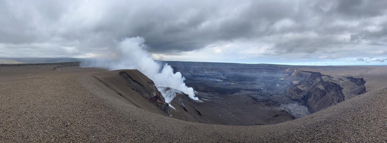
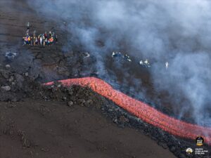
This panoramic image shows Halema‘uma‘u crater a few days after the end of episode 33 of the ongoing eruption of Kīlauea volcano. This photo, looking eastward (north is left, south is right), was taken from near the top of the mound of tephra that has accumulated west of Halema‘uma‘u since the start of the eruption in December 2024. The south vent is vigorously degassing, and the north vent is just out of view. Wind conditions at the time were blowing the combined north and south vent volcanic plume to north towards Uēkahuna; most of the time tradewinds blow the plume over where the photographer is standing.
EARTHQUAKE INTENSITY AND AFFECTED AREA
Potential Damage: No damage to buildings or infrastructure expected based on earthquake intensity
Maximum Intensity, Modified Mercalli Scale (https:// www.usgs.gov/natural-hazards/earthquake-hazards/science/modified-mercalli-intensity-scale)
Community-reported: V – moderate shaking
Instrument-derived: III – weak shaking
Felt Reports: More than 39 within the first half hour
The Hawaiian Volcano Observatory is one of five volcano observatories within the U.S. Geological Survey and is responsible for monitoring volcanoes and earthquakes in Hawaiʻi and American Samoa.
Source : HVO.
Photo : USGS /N. Deligne.
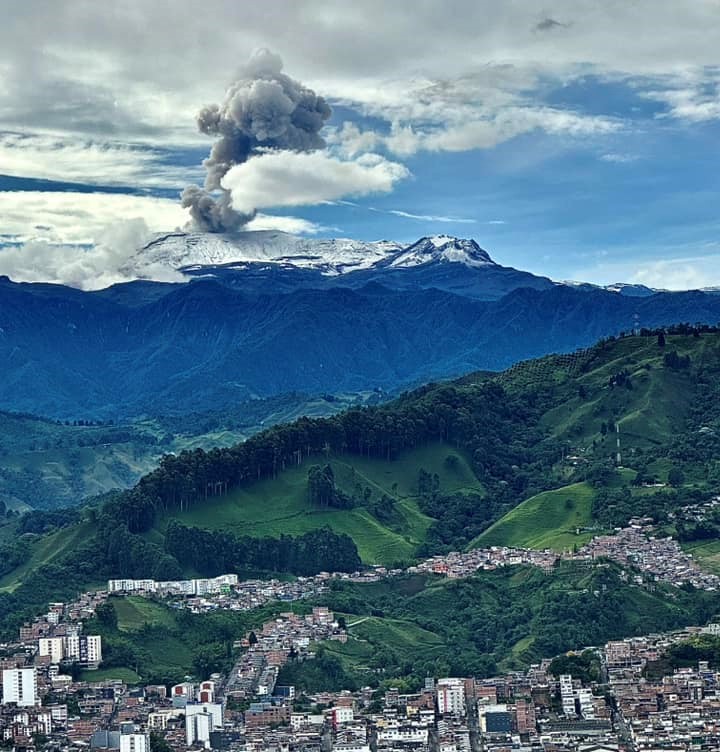
Colombia , Nevado del Ruiz :
Manizales, September 30, 2025, 5:30 p.m.
Regarding the monitoring of the activity of the Nevado del Ruiz volcano, the Colombian Geological Survey (SGC), an entity attached to the Ministry of Mines and Energy, reports that:
During the week of September 23 to 29, 2025, the volcano continued to exhibit unstable behavior. Compared to the previous week, the main variations in the monitored parameters were:
– Seismic activity associated with rock fracturing processes within the volcanic edifice increased slightly, both in terms of the number of recorded earthquakes and the seismic energy released. The earthquakes were mainly located in the Arenas crater, at a depth of less than 3 km, measured from the volcano’s summit. To a lesser extent, seismic activity was observed on the south-southwest, south-southeast, and northeastern flanks of the volcano, at distances up to 11 km from the Arenas crater. The largest event was recorded on September 25 at 2:51 a.m., with a magnitude of 1.5, in the Arenas crater, at a depth of 2 km.
– Seismic activity related to fluid dynamics in volcanic conduits decreased, both in the number of recorded earthquakes and in the seismic energy released for short-duration signals. Long-duration signals continued to occur this week, increasing in both number and seismic energy released. The energy levels of the seismic events were generally low. Thanks to the cameras (conventional or thermographic) used to monitor the volcano and the reports from the officials of the Los Nevados National Natural Park (PNN), several pulsed ash emissions and variations in the apparent temperature of the emitted materials have been confirmed.
– On September 28, seismic activity was recorded related to the lava dome (protuberance or mound) located at the crater floor, characterized by low seismic energy levels. The volcano continues to emit water vapor and volcanic gases, primarily sulfur dioxide (SO₂), into the atmosphere. SO₂ flux values increased compared to data estimated the previous week. This trend was also confirmed by satellite monitoring of this parameter.
The vertical height of the gas, water vapor, or ash column generally remained below the 800 m measured above the volcano’s summit and reached a maximum height of 1,200 m. The maximum dispersion height reached 2,500 m, a value measured during the ash emission recorded on September 28 at 9:42 a.m. During the week, the dispersion direction was oriented towards the northwest flank of the volcano and, to a lesser extent, towards the west flank. Due to this preferential wind direction, ashfall occurred in the Valle de las Tumbas sector, within the national park.
Monitoring of thermal anomalies at the floor of the Arenas crater using satellite monitoring platforms limited detection due to persistent atmospheric conditions of high cloud cover in the volcanic area. However, reports of some low-energy anomalies were obtained.
Source et photo : SGC.
Kamchatka , Kronotsky :
VOLCANO OBSERVATORY NOTICE FOR AVIATION (VONA)
Issued: October 4 , 2025
Volcano: Kronotsky (CAVW #300200)
Current aviation colour code: RED
Previous aviation colour code: green
Source: KVERT
Notice Number: 2025-105
Volcano Location: N 54 deg 45 min E 160 deg 31 min
Area: Kamchatka, Russia
Summit Elevation: 3528 m (11571.84 ft)
Volcanic Activity Summary:
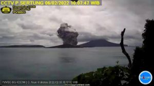
Probably an explosive eruption began of Kronotsky volcano at 22:30 UTC on 03 October, 2025. An ash cloud 85×40 km continues to increased at the southern flank of the volcano.
An explosive eruption of the volcano continues. Ash explosions up to 15 km (49,200 ft) a.s.l. could occur at any time. Ongoing activity could affect international and low-flying aircraft.
Volcanic cloud height:
9000-9200 m (29520-30176 ft) AMSL Time and method of ash plume/cloud height determination: 20251003/2350Z – Himawari-9 14m15
Other volcanic cloud information:
Distance of ash plume/cloud of the volcano: 85 km (53 mi)
Direction of drift of ash plume/cloud of the volcano: SSE / azimuth 152 deg
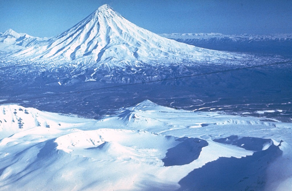
The symmetrical Kronotsky stratovolcano lies between the Pacific Ocean and Lake Kronotsky, Kamchatka’s largest lake. The lake formed during the late Pleistocene and early Holocene when extensive lava flows on the south side of Kronotsky volcano dammed the Listvenichnaya River. The flanks of the massive volcano are dissected by radial valleys up to 200 m deep. A volcanic neck plugs the summit crater. Cinder cones are found on the north and primarily on the SE and SW flanks. Kronotsky lavas have been dominantly basaltic, with the exception of the small basaltic andesite summit lava extrusion and a flank lava flow. Weak phreatic eruptions took place in the 20th century.
Issued: October 4 , 2025
Current aviation colour code: ORANGE
Previous aviation colour code: red
Volcanic Activity Summary:
The phreatic explosive eruption of Kronotsky Volcano has likely ended. A cloud 272 x 84 km in size, containing water and some amount of ash, continues to move eastward from the volcano (the edge of the cloud is 190 km from the volcano to the east). The cloud height dropped to 5 km a.s.l.
KVERT continues to monitor Kronotsky volcano.
The phreatic explosive eruption of Kronotsky Volcano has likely ended. Ongoing activity could affect low-flying aircraft.
Volcanic cloud height:
5000 m (16400 ft) AMSL Time and method of ash plume/cloud height determination: 20251004/0330Z – Himawari-9 14m15
Other volcanic cloud information:
Distance of ash plume/cloud of the volcano: 190 km (118 mi)
Direction of drift of ash plume/cloud of the volcano: E / azimuth 98 deg
Time and method of ash plume/cloud determination: 20251004/0330Z – Himawari-9 14m15
Sources : Kvert , GVP.
Photo : Yuri Doubik (Institute of Volcanology, Petropavlovsk) / GVP.
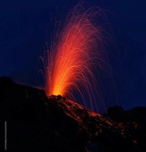
Chile , Planchón Peteroa :
Special Volcanic Activity Report (REAV)
Maule Region, October 3, 2025, 11:50 p.m. local time (Continental Chile)
The Chilean National Geology and Mining Service (Sernageomin) releases the following preliminary information, obtained using the monitoring equipment of the National Volcanic Monitoring Network (RNVV), processed and analyzed at the Southern Andean Volcanological Observatory (OVDAS):
On Friday, October 3, images from surveillance cameras installed near the Planchón Peteroa volcanic complex and satellite images revealed a change in color and an increase in degassing, a first since the yellow alert was raised.
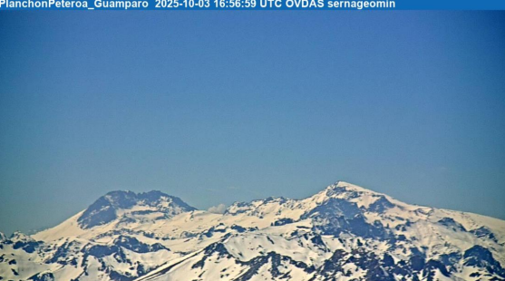
Image from the Guámparo surveillance camera, dated October 3, 2025, at 1:56 PM HL (4:56 PM UTC).
Figure 1 illustrates the evolution of the degassing, reaching heights close to 200 meters from the edge of the complex.
Figure 2 shows the Sentinel 2-L2A satellite image (https://browser.dataspace.copernicus.eu/) of the area of interest, suggesting the presence of pyroclastic materials in the emission from the Southwest crater. Their dispersion is continuous in a southeast direction, with an estimated range of 8 kilometers. Probably due to the characteristics of the emission (low altitude and concentration of pyroclasts), it was not identified by the GOES platform.
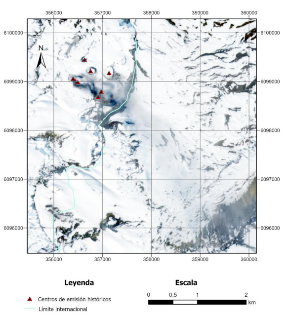
Emission with pyroclasts in the Sentinel 2-L2A satellite image dated October 3, 2025, indicating the location of historical emission centers.
Sulfur dioxide (SO2) satellite images from October 3 do not show significant changes in the volcanic system. However, the frequency of these anomalies has increased since September 27, according to information obtained from the Mounts Project platform.
According to the latest volcanic activity reports provided by SERNAGEOMIN for this system, and taking into account the above, the occurrence of new episodes of similar energy, sudden explosions of low to moderate magnitude, without precursors, affecting the immediate vicinity of active craters, cannot be ruled out.
Source et photos : Sernageomin.
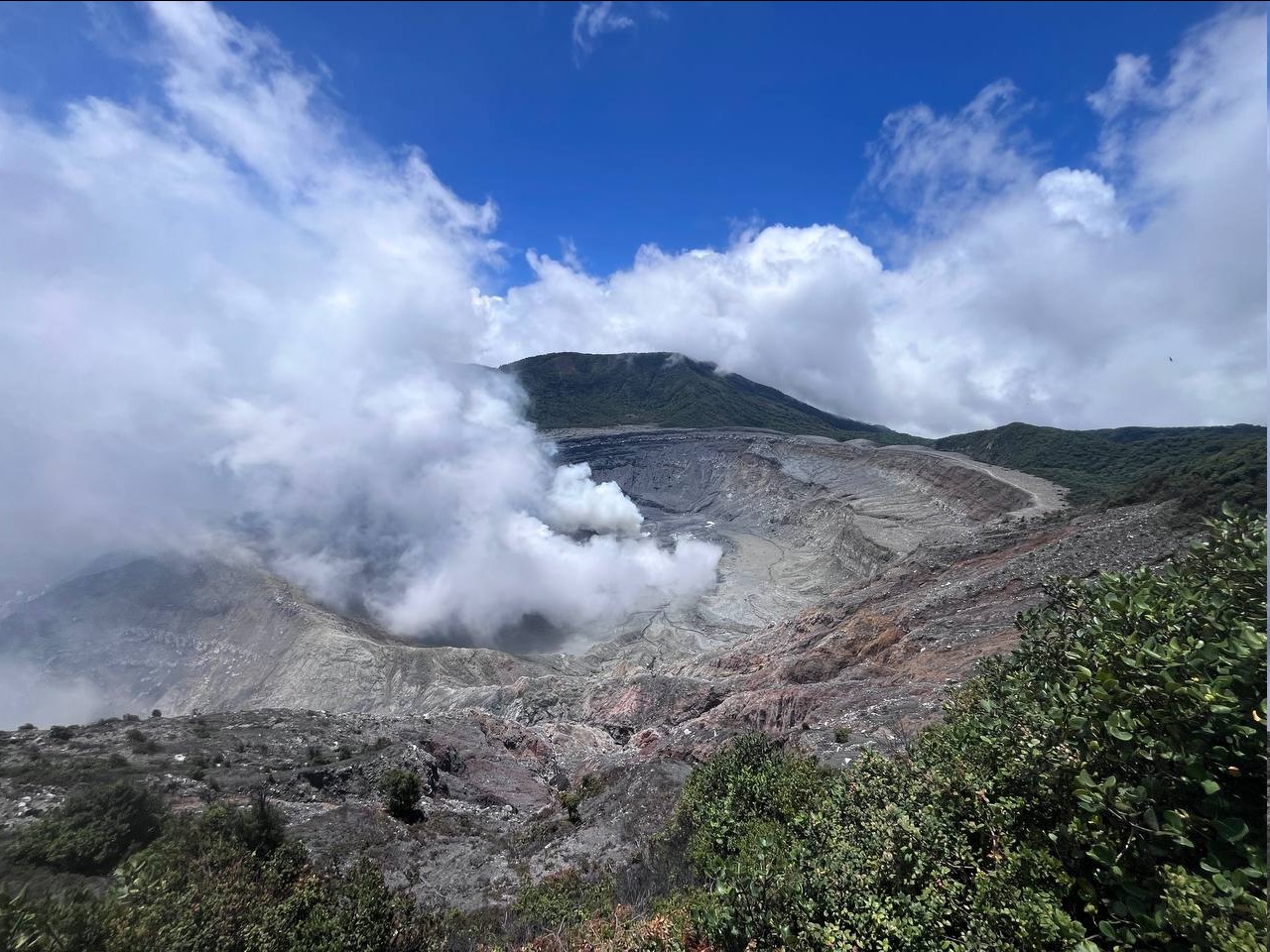
Costa Rica , Poas :
OVSICORI-UNA Weekly Volcano Monitoring Bulletin, October 3, 2025
Latitude: 10.20°N;
Longitude: 84.23°W;
Altitude: 2,687 m
Current Activity Level: Alert
Since September 9, the date of the last eruption, background tremor has gradually increased. This week, it reached its four-month peak (the rest period following the eruptive period from February to May). A slight increase in acoustic tremor was observed this week, and 15 proximal volcano-tectonic earthquakes were recorded. Most were located on the southern flank, near the entrance to the national park, between 2 and 3 km below sea level. However, the last event occurred beneath the active crater, at a depth of 3 km. The number of long-period events peaked since the beginning of the year on September 27 and has been steadily decreasing since then. The geodetic network does not record any significant short-term deformation, but shows a slight shrinkage of the crater over the past six months.
MultiGAS stations measured an average SO2/CO2 ratio of 1.6 ± 0.7 this week, similar to last week’s (1.7 ± 0.4). The H2S/SO2 ratio has remained very low (< 0.1) in recent weeks. The ExpoGAS station, located on the visitor observation deck, measured a maximum of 9.1 ppm SO2 this week, representing elevated concentrations. DOAS stations measured an SO2 flux of 205 ± 76 t/d, slightly lower than last week’s (272 ± 102 t/d). Furthermore, satellite measurements of atmospheric SO2 remained detectable, with a peak of 280 tons on September 27 (possibly combined with the Turrialba volcano plume), down from last week.
This week, the lake level rose by about 2 meters due to the rains of September 27, 28 and 29.
Source : Ovsicori .
Photo : RSN-UCR.