September 13 , 2025.
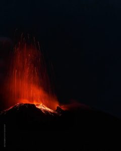
Kamchatka , Sheveluch :
VOLCANO OBSERVATORY NOTICE FOR AVIATION (VONA)
Issued: September 12 , 2025
Volcano: Sheveluch (CAVW #300270)
Current aviation colour code: ORANGE
Previous aviation colour code: orange
Source: KVERT
Notice Number: 2025-83
Volcano Location: N 56 deg 38 min E 161 deg 18 min
Area: Kamchatka, Russia
Summit Elevation: 3283 m (10768.24 ft), the dome elevation ~2500 m (8200 ft)
Volcanic Activity Summary:
An extrusive-effusive eruption of the Young Sheveluch volcano continues. According to video data by KVERT, explosions sent ash up to 4.5 km a.s.l., and an ash cloud continues to move to the east of the volcano.
An extrusive-effusive eruption of the volcano continues. The danger of ash explosions up to 10 km (32,800 ft) a.s.l. remains. Ongoing activity could affect international and low-flying aircraft.
Volcanic cloud height:
4500 m (14760 ft) AMSL Time and method of ash plume/cloud height determination: 20250912/0526Z – Video data
Other volcanic cloud information:
Distance of ash plume/cloud of the volcano: 10 km (6 mi)
Direction of drift of ash plume/cloud of the volcano: E
Time and method of ash plume/cloud determination: 20250912/0526Z – Video data
Source : Kvert
Photo : Viktor Frolov
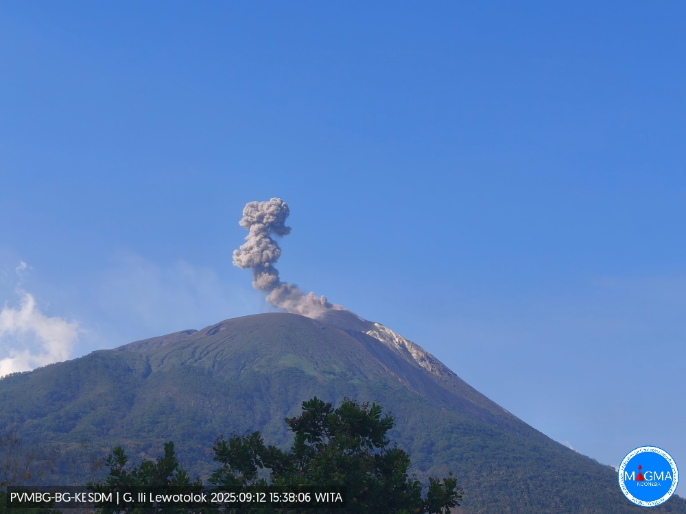
Indonesia , Ili Lewotolok :
An eruption of Mount Ili Lewotolok occurred on Friday, September 12, 2025, at 3:37 PM (local time). An ash column was observed about 600 m above the summit (about 2,023 m above sea level). The observed ash column was white to gray in color, with a strong intensity directed toward the west. This eruption was recorded by seismograph with a maximum amplitude of 5.1 mm and a duration of 33 seconds.
Seismic Observations
32 eruption earthquakes with amplitudes ranging from 15.9 to 32.7 mm and durations ranging from 26 to 46 seconds.
42 emission earthquakes with amplitudes ranging from 1.4 to 9 mm and durations ranging from 26 to 33 seconds.
1 distant tectonic earthquake with amplitudes of 2 mm and durations of 236 seconds.
Recommendations
At Activity Level III (Siaga):
[1] Residents living near Mount Ili Lewotolok, as well as visitors, mountaineers, and tourists, are advised to refrain from entering or carrying out activities within a 3 km radius of the activity center of Mount Ili Lewotolok. Be aware of the potential dangers of lava avalanches and pyroclastic flows emanating from the south, southeast, west, and northeast sectors of Mount Ili Lewotolok.
(2) The public is advised not to panic if they hear a rumbling noise coming from the crater of Mount Ili Lewotolok, as this noise is characteristic of volcanic activity during an eruption. This powerful rumbling noise can cause severe vibrations in several parts of the building, particularly windows and glass doors.
Source et photo : Magma Indonésie .
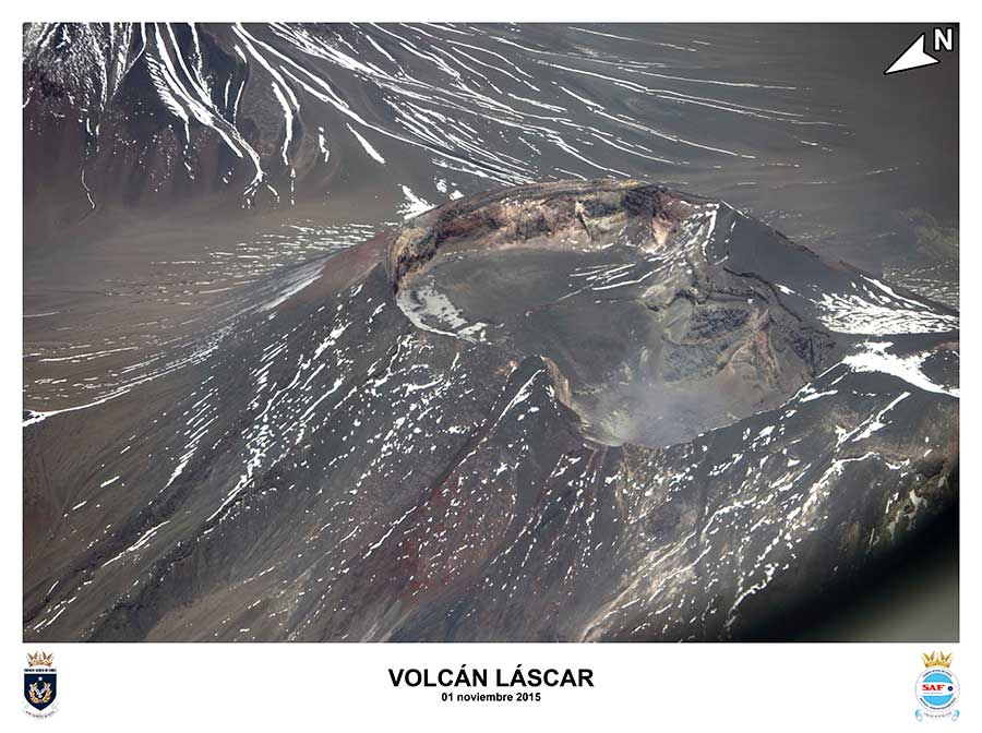
Chile , Lascar :
Seismology
Seismological activity during this period was characterized by the following:
Five VT-type seismic events, associated with rock fracturing (volcano-tectonics). The most energetic earthquake, with a local magnitude (LM) of 1.2, was located 0.3 km south-southwest of the volcanic edifice, at a depth of 2.6 km.
Seven LP-type seismic events, associated with fluid dynamics within the volcanic system (long period). The magnitude of the largest earthquake, estimated using the reduced displacement (RD) parameter, was 6 cm².
Fluid Geochemistry
Thirteen anomalies in sulfur dioxide (SO₂) emissions into the atmosphere were reported in the area near the volcano, according to data published by the Tropospheric Monitoring Instrument (TROPOMI) and the Sulfur Dioxide Group of the Ozone Monitoring Instrument (OMI) for the month of August.
Satellite Thermal Anomalies
During this period, 89 thermal anomalies were detected in the volcanic area, according to the MIROVA platform. The highest thermal energy recorded was 2.7 MW on August 6 (according to the MODIS sensor), 3.4 MW on August 13 (according to the VIIRS 750 sensor), and 3.9 MW on August 13 (according to the VIIRS 375 sensor).
During the month, five Sentinel 2-L2A satellite images were available on August 5, 10, 15, 20, and 25.
Processed as false-color bands, they reveal two areas of anomalous thermal radiation within the active crater. In addition, the NHI (Normalized Hotspot Indices) platform (Marchese et al., 2019) estimated a total radiance area of 1,800 m² on August 27, consistent with the decreasing trend in thermal anomalies, which is considered weak.
Geodesy
Geodetic activity during the period was characterized by:
– Low vertical GNSS deformation rates, with amplitude variations less than 0.5 cm/month and in a deflationary direction, a value considered low.
– Low horizontal variation rates at GNSS monitoring stations, with variations of approximately 0.2 cm/month, a value considered low.
– Sentinel 1A (Single Look Complex-SLC) imaging radar (InSAR) interferometry showed no signs of deformation.
Therefore, no significant changes associated with the deformation of the volcanic system were observed.
Surveillance Cameras
Surveillance cameras installed near the volcano, when weather conditions permitted, recorded whitish passive degassing columns. The maximum reached 560 meters above the crater level on August 28. No incandescence was observed during the period assessed.
Satellite Geomorphological Analysis
According to Planet Scope Scene satellite images, no morphological changes have been identified. On August 25, degassing was recorded at the floor of the active crater.
Activity remained at levels considered low, suggesting the volcano’s stability.
The technical volcanic alert remains in effect:
GREEN TECHNICAL ALERT: Active Volcano with Stable Behavior – No Immediate Risk
Observation:
Given the behavior of this volcanic system observed over the past ten years, sudden, unpredictable, low-magnitude explosions affecting the immediate vicinity of the active crater cannot be ruled out. However, given its base level, this type of event is infrequent; its probability of occurrence is therefore considered low. Risks associated with this minor activity include the ejection of ballistic pyroclasts, ash emission, and volcanic gas emission.
Source : Sernageomin
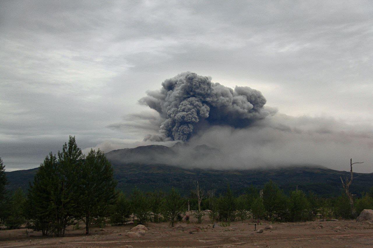
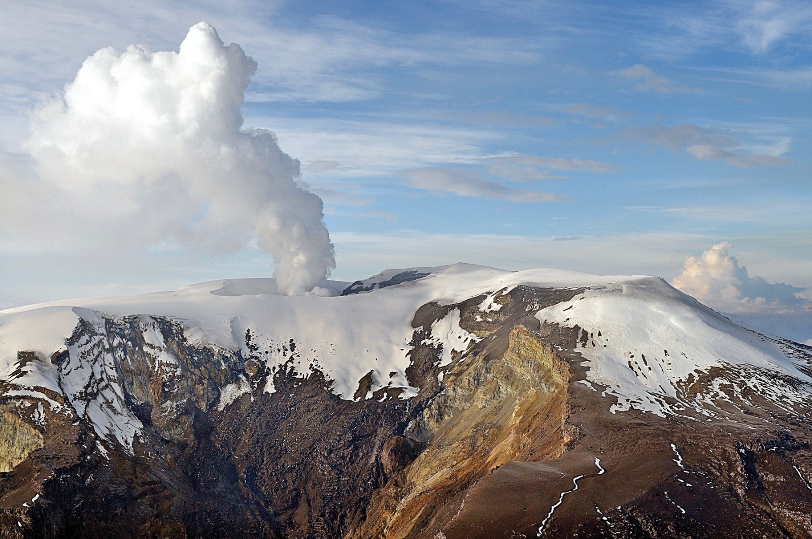
Colombia , Nevado del Ruiz :
Manizales, September 9, 2025, 6:45 p.m.
Regarding the monitoring of the activity of the Nevado del Ruiz volcano, the Colombian Geological Survey (SGC), an entity attached to the Ministry of Mines and Energy, reports that:
During the week of September 2 to 8, 2025, the volcano continued to exhibit unstable behavior. Compared to the previous week, the main variations in the monitored parameters were:
– Seismic activity associated with rock fracturing processes within the volcanic edifice increased, both in terms of the number of recorded earthquakes and the seismic energy released. The earthquakes were mainly located on the northwest flank, at distances between 3 and 4 km from the Arenas crater and at depths between 4 and 6 km from the volcano’s summit. To a lesser extent, earthquakes were recorded in the Arenas crater at depths of less than 2 km and, scattered, on the southwest, southeast, east-southeast, northeast, and distal northwest flanks, at distances of up to 10 km from the crater and at depths between less than 1 km and 9 km. It is worth noting the seismic increase recorded on September 5 and 6 in the northwest sector of the volcano, a period in which the largest number of events of the week occurred, as well as the largest earthquake. The latter, corresponding to the event of September 5 at 6:31 a.m., was located 3 km northwest of the volcanic structure and at a depth of 5 km, with a magnitude of 2.6.
Seismicity related to fluid dynamics in volcanic conduits:
An increase in the number of recorded earthquakes and a decrease in the seismic energy released. This seismicity was mainly characterized by short-duration signals and low energy levels. The cameras (conventional or thermographic) used to monitor the volcano and reports from Los Nevados National Park (PNN) officials confirmed several pulsed ash emissions and some changes in the apparent temperature of the materials emitted during these emissions.
– The emission of water vapor and volcanic gases, mainly sulfur dioxide (SO₂), into the atmosphere through the Arenas crater varied throughout the week. Daily SO₂ degassing flux rates showed values similar to those estimated the previous week, a trend also highlighted by satellite monitoring of this parameter. – The vertical height of the column of gas, water vapor, or ash reached 800 m above the volcano’s summit, although it remained below 500 m most of the time. The maximum estimated dispersion height was 1,100 m during the ash emission on September 8 at 6:24 p.m. Regarding the dispersion direction, the column had a preferential tendency toward the northwest and west flanks of the volcano and, to a lesser extent, toward the west and southwest flanks. According to these preferential directions, ashfall was confirmed on September 6 and 7 in the Arenales, Valle de las Tumbas, and La Olleta sectors of the national park.
– No reports of thermal anomalies were obtained during satellite monitoring at the floor of the Arenas crater. Indeed, their detection was limited by the persistent cloudy sky in the volcanic area.
Source et photo : SGC
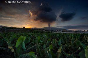
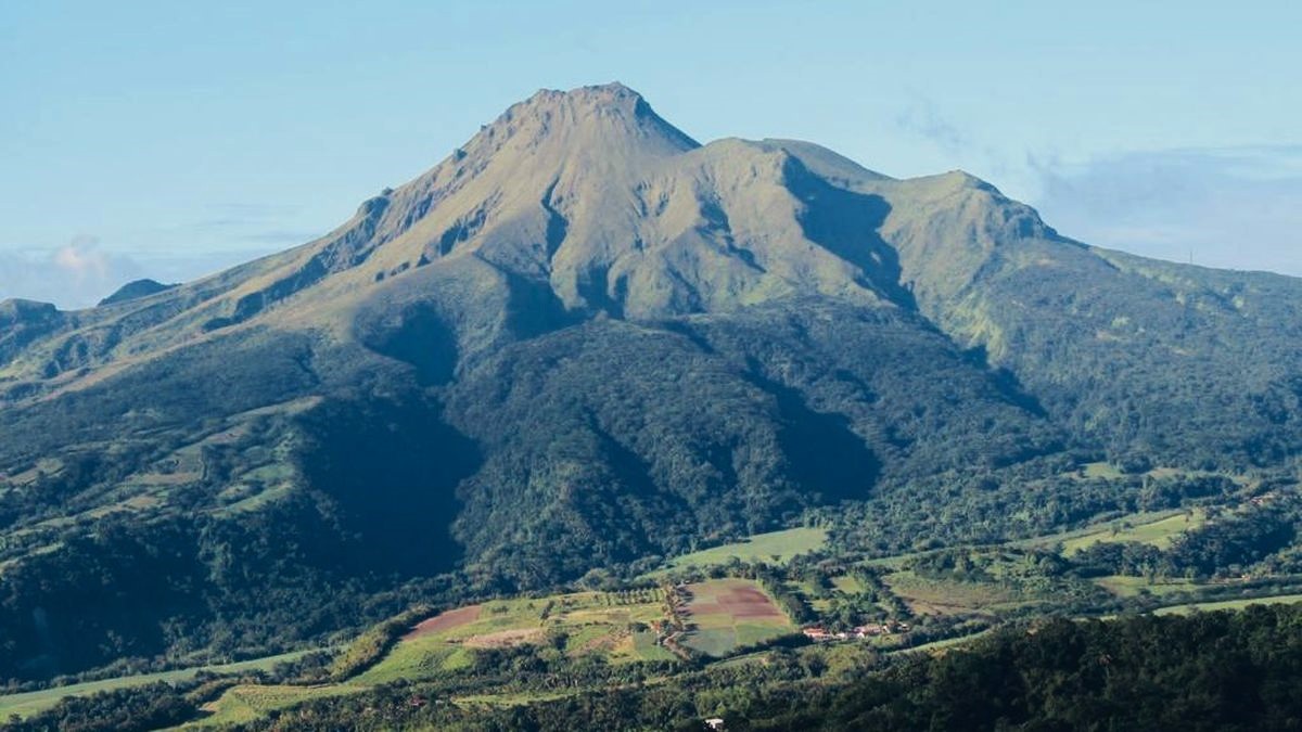
La Martinique , Mount Pelée :
Weekly Report, Paris Institute of Earth Physics, Martinique Volcanological and Seismological Observatory
Saint-Pierre, September 12, 2025 at 4:45 p.m. local time (GMT-4)
Volcanic activity increased this week with 598 earthquakes of volcanic origin observed.
Between September 5, 2025 at 4:00 p.m. (UT) and September 12, 2025 at 4:00 p.m. (UT), the OVSM recorded:
-545 volcano-tectonic earthquakes. Among them, 8 had a duration magnitude greater than Md = 0.5, and the largest had a magnitude Md = 1.15. The others were of lower energy. These earthquakes were clearly identified as originating from one of the well-known seismically active zones on Mount Pelée, located between 1.0 and 1.4 km deep below the volcano’s summit. The shallow volcano-tectonic seismicity is associated with microfracturing in the volcanic edifice, linked to the global reactivation of the volcano observed since 2019.
– 34 shallow hybrid earthquakes, with a maximum local magnitude of Mlv = 1.12, located approximately 1 km deep beneath the domes of Mount Pelée in the same area as the volcano-tectonic earthquakes. Hybrid seismic signals are enriched in low frequencies and are associated with the circulation of fluids (gas, hydrothermal fluids) within the volcanic edifice.
– 19 shallow long-period earthquakes, of low energy, located in the same area as the volcano-tectonic earthquakes. Long-period earthquakes are characterized by signals
containing only low frequencies and are associated with the circulation of fluids within the volcanic edifice.
No earthquakes were felt by the population.
The previous week, the OVSM had recorded 517 earthquakes of volcanic origin. As of September 12, 2025, and over the past four weeks, the OVSM has observed a total of 2,143 volcanic earthquakes, or an average of 535 to 536 earthquakes per week.
During phases of volcanic reactivation in volcanoes similar to Mount Pelée, seismic activity of varying intensity and frequency is commonly observed.
For more details on observations and interpretations of volcanic activity over the longer term, refer to the OVSM’s monthly bulletins.
The alert level is currently YELLOW: vigilance.
Source et photo : Direction de l’OVSM-IPGP.