August 20 , 2025.
Italy / Sicily , Etna :
Etna Activity Statement, August 19, 2025, 12:08 PM (10:08 UTC)
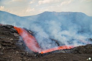
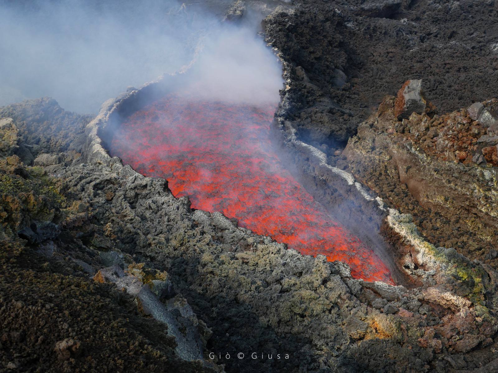
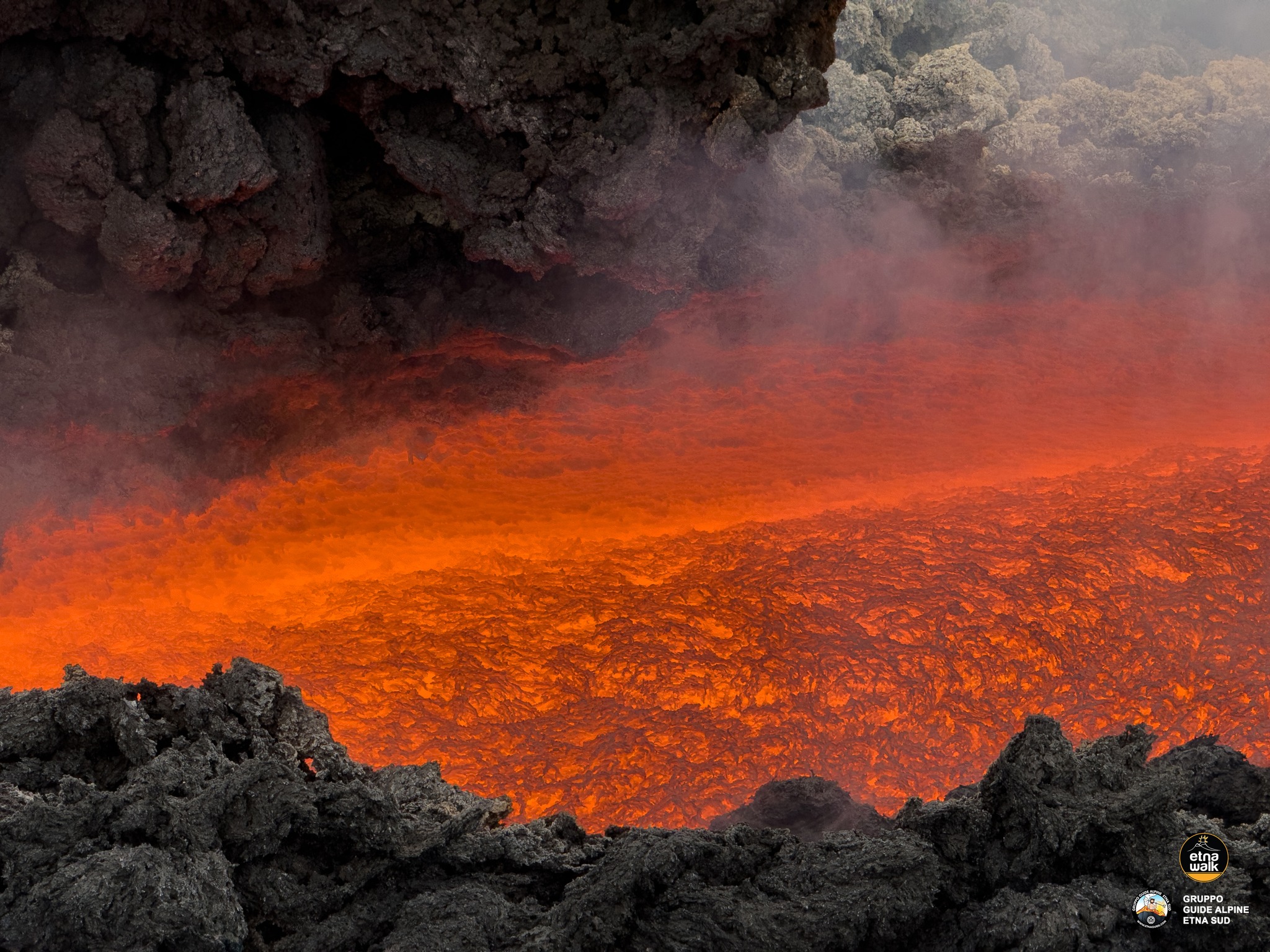
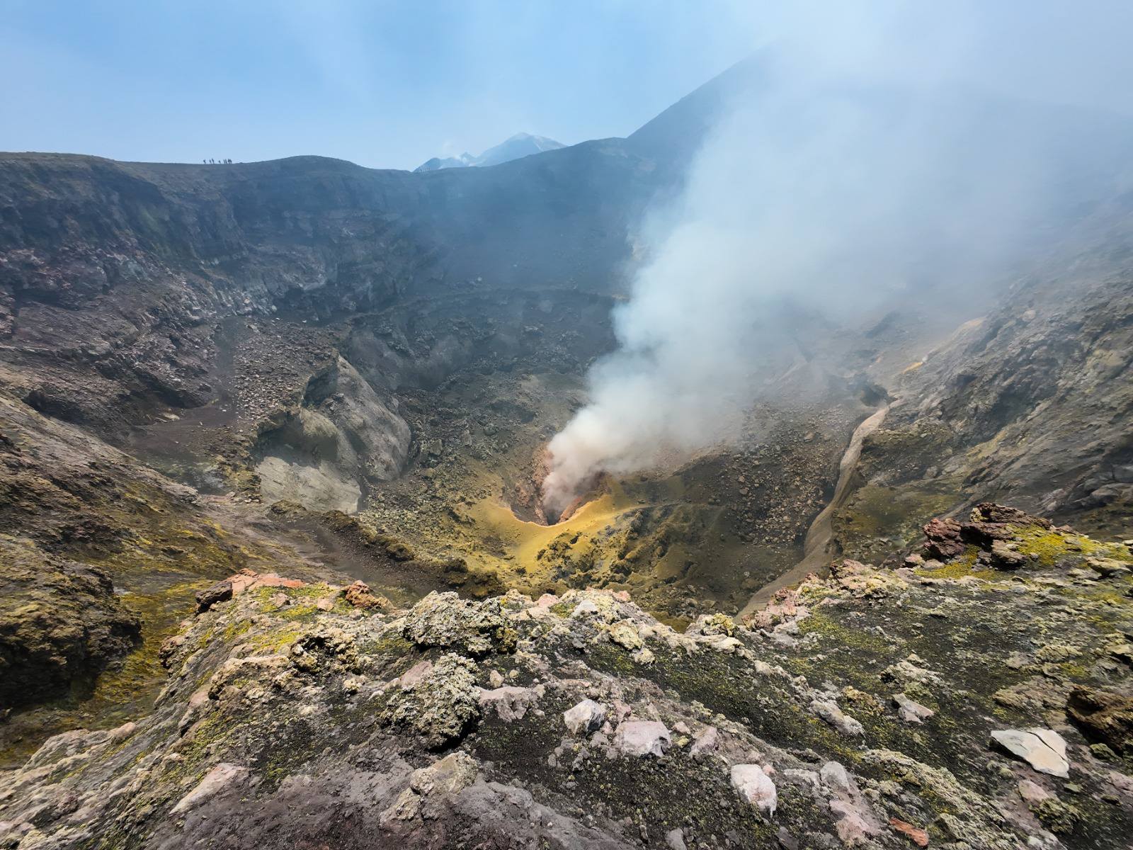
The National Institute of Geophysics and Volcanology, Osservatorio Etneo, announces that, based on field surveys conducted by INGV personnel, satellite image analysis, and surveillance cameras, it has been observed that the active effusive crater at an altitude of 2,980 m is still active and feeding a lava field that, in the proximal area, has developed a lava tube and several ephemeral vents, while in the distal area, it divides into two main branches advancing southwestward. The most advanced front is located at an altitude of approximately 2,270 m, upstream of the Grotta degli Archi, about 2 km from the slope of Altamontana. Strombolian explosive activity continues in the Southeast Crater with varying intensity. Episodic emissions of reddish ash have also been observed from the Bocca Nuova Crater.

The average amplitude of the volcanic tremor, which began around 9:00 p.m. on August 18, reached high values and currently persists with weak oscillations. The source of the tremor is located in an area near the Southeast Crater, at a depth between 2,900 and 3,000 meters above mean sea level.
Infrasound activity is moderate, with events mainly located in the Southeast Crater and characterized by medium amplitude.
Signals from GNSS and inclinometric deformation monitoring networks show no significant variation. The DRUV dilatometric station has recorded a gradual reversal of its usual trend in recent days.
Additional information will be provided shortly.
WEEKLY BULLETIN, from August 11, 2025 to August 17, 2025. (Publication date August 19, 2025)
ACTIVITY SUMMARY
Based on monitoring data, the following elements are highlighted:
1) VOLCANOLOGICAL OBSERVATIONS: Effusive activity from an eruptive fissure at the base of the Bocca Nuova crater, Strombolian activity at the Southeast crater, and degassing of varying intensity at the Voragine crater and the Northeast crater. Degassing of varying intensity and episodic ash emissions at the Bocca Nuova crater.
2) SEISMOLOGICAL: Absence of seismic activity due to fracturing with Ml >=2.0; tremor amplitude remained mainly at moderate levels.
3) INFRASOUND: Moderate infrasound activity.
4) GROUND DEFORMATION: GNSS and inclinometer networks monitoring ground deformation have not measured any significant changes.
5) GEOCHEMISTRY: SO2 flux at low levels
CO2 flux from the soil (Etnagas Network): The flux shows an increase, remaining at low values.
Dissolved CO2 in groundwater (EtnaAcque Network): No update.
Isotope ratio at peripheral sites: The latest data from August 5 are high.
6) SATELLITE OBSERVATIONS: Thermal activity observed by satellite in the summit area was generally moderate to high, consistent with ongoing effusive activity.
VOLCANOLOGICAL OBSERVATIONS
After the brief lava flow that occurred between August 9 and 10 in the late evening, Etna exhibited modest and irregular Strombolian activity at the Southeast Crater (CSE) and variable degassing at the other summit craters: Bocca Nuova (BN), Voragine (VOR), and the Northeast Crater (CNE). On August 14, at 00:45 local time, renewed effusive activity was observed, fueled by an active vent (~2,980 m a.s.l.; 37.74195 N, 14.98967 E) along an eruptive fissure located between the CSE and CNE. The eruptive fissure developed along the alignment of the eruptive chimneys that fueled the effusive activity of February-March and 9-10 August 2025, located at altitudes of 3,100 and 3,050 m above sea level, respectively.
From direct observations made by INGV-OE personnel on 14 February, it was observed that the eruptive fissure had propagated in a southwesterly direction and that a northeast-southwest oriented dry fracture field had also developed in the area. It was also observed that the initial phase of the effusive activity had produced a 2-3 meter wide lava flow, followed by the main flow, which then propagated in a southwesterly direction. During inspections carried out on Sunday 17 August and today, it was observed that the effusive vent was still active and feeding a lava field which, in the proximal area, had developed a lava tunnel and several ephemeral vents. In particular, field surveys and analysis of satellite images this morning revealed that, in the distal area, the lava flow splits into two main branches, both advancing southwestward. The most advanced front this morning was located at an altitude of approximately 2,270 m above sea level, upstream of the Grotta degli Archi and approximately 2 km from the slope of Altamontana.
Strombolian activity at the Southeast Crater intensified at the beginning of the effusive activity, although its regime was variable. Finally, activity at the other craters was characterized by degassing at varying speeds and intensity, with the Bocca Nuova (BN) producing episodic emissions of reddish ash, probably associated with pressurized gas emissions.
Source : INGV
Photos : Gio Giusa, EtnaWalk / Giuseppe Distefano – Marco Restivo , Guide Etna Nord-Compagnie guide Etna
Italy , Stromboli :
WEEKLY BULLETIN, from August 11, 2025 to August 17, 2025. (Publication date August 19, 2025)
ACTIVITY SUMMARY
Based on monitoring data, the following are highlighted:
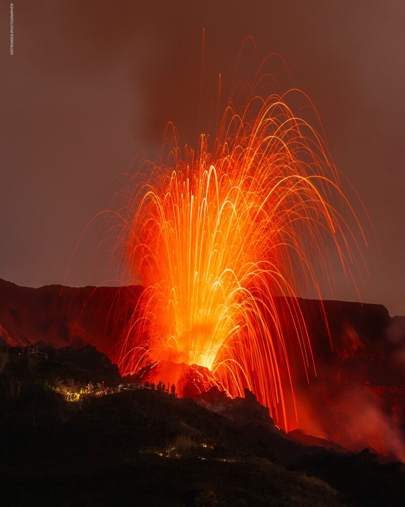
VOLCANOLOGICAL OBSERVATIONS: During this period, ordinary Strombolian eruptive activity was observed, with spattering in the northern area. The total hourly frequency ranged from medium (11 events/h) to high (16 events/h). The intensity of the explosions was low and medium in the North (N) and South-Central (SC) crater areas.
2) SEISMOLOGY: The monitored seismic parameters show no significant variation.
3) GROUND DEFORMATION: The ground deformation monitoring networks did not measure any significant variation. 4) GEOCHEMISTRY: SO2 flux at an average level
CO2 flux from the soil in the Pizzo area (STR02): Due to technical issues, no update is available. The latest recorded values (August 3) are average to high.
The C/S ratio in the plume remains at average values.
Helium isotope ratio (R/Ra) dissolved in the thermal aquifer: No update. The latest values (July 9) are high.
The CO2 flux in the soil in the Scari area is high.
5) SATELLITE OBSERVATIONS: Thermal activity observed by satellite in the summit area was generally low, with some isolated moderate thermal anomalies.
VOLCANOLOGICAL OBSERVATIONS
During the observation period, Stromboli’s eruptive activity was characterized by analyzing images recorded by the INGV-OE surveillance cameras located at an altitude of 190 m (SCT-SCV) and at Punta dei Corvi (SPCT). Due to a power outage at the station located at an altitude of 190 m, images from both SCT-SCV cameras were absent from 11:34 UTC on August 17 to 5:58 UTC on August 18. The explosive activity was mainly produced by four eruptive vents located in the North Crater area and at least two vents in the Central-South area.
Observations of explosive activity captured by surveillance cameras
Four active vents were observed in the North (N) crater area, producing low-intensity explosive activity (less than 80 m in height) and occasionally medium-intensity explosive activity (less than 150 m in height). Additionally, on August 17, weak eruptive activity was observed in the N2 sector. The eruptive products consisted mainly of coarse materials (bombs and lapilli). The average explosion frequency was between 10 and 14 events per hour.
In the South-Central (SC) area, the observed eruptive activity consisted of medium- to low-intensity fine-material explosions. The average explosion frequency ranged from less than 1 to 4 events per hour.
Source : INGV
Photo : Stromboli stati d’animo / Sebastiano Cannavo .
New Zealand , Ruapehu :
Te Wai ā-moe (Ruapehu Crater Lake) is now warming up. The Volcanic Alert Level remains at 1
Published: Wed Aug 20 2025 10:00 AM
Volcanic Alert Level remains at 1
Aviation Colour Code remains at Green
Te Wai ā-moe (Ruapehu Crater Lake) is now heating again. Since mid-July the lake temperature has been rising and is now 16 °C. Earthquake, volcano gas, lake chemistry and volcanic tremor data are all within typical ranges, and no unusual changes have been observed. The Volcanic Alert Level remains at 1 and the Aviation Colour Code at Green.
A well established and normal behaviour for the Crater Lake is to go through successive heating and cooling periods that commonly last several months. The lake temperature typically peaks at 30-40 °C and cools to 10-15 °C.The lake reached 10 °C before starting the latest heating.

Lake heating is commonly caused by more hot gas and steam getting into the lake from vents at the bottom. This disturbs sediment on the lake floor which becomes suspended in the water, changing the colour from a blue green tinge to a more grey colour. Minor upwellings of hot water are also present at the lake surface, as are yellow sulphur slicks.
The amount of gas passing through the lake is within the normal range and volcanic tremor remains low.
Taken together, the observations indicate Ruapehu continues to exhibit typical low levels of activity consistent with minor volcanic unrest; therefore, the Volcanic Alert Level remains at 1 and the Aviation Colour Code remains Green.
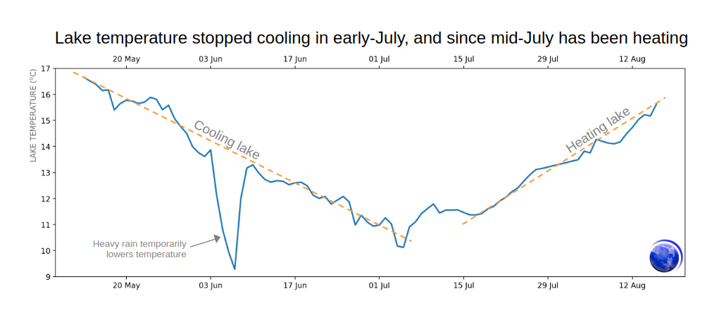
Te Wai ā-moe (Ruapehu Crater Lake) has recently changed from cooling to heating. Daily mean temperature data collected by a monitoring station at the lake (https://tilde.geonet.org.nz/).
More information:
Mt Ruapehu is an active volcano and has the potential to erupt with little or no warning when in a state of minor volcanic unrest.
Volcanic Alert Level 1 indicates the primary hazards are those expected during volcanic unrest: steam discharge, volcanic gas, earthquakes, landslides, and hydrothermal activity. While Volcanic Alert Level 1 is mostly associated with environmental hazards, potential for eruption hazards also exists and eruptions can still occur with little or no warning. Volcanic Alert Levels 3, 4 and 5 are reserved for eruptions with varying impact distances.
Source : Geonet / Steve Sherburn / Duty Volcanologist.
Photos : Geonet , Bradd Scott .
Iceland , Reykjanes Peninsula:
Earthquake in Brennisteinsfjöll – Faster Subsidence in Krýsuvík and Continued Magma Accumulation at Svartsengi
19.8.2025
Potential for larger earthquakes in Brennisteinsfjöll
Deformation detected in the Krýsuvík area
Ongoing uplift at Svartsengi
An earthquake measuring magnitude 3.2 struck southwest Iceland shortly after 18:00 yesterday and was felt in the capital area. The quake was located in Brennisteinsfjöll, an active seismic zone. Since the onset of activity on the Reykjanes Peninsula in 2020, seismicity in this area has increased, reflecting growing stress accumulation in the crust.
It should be noted that strong earthquakes recur in this region, although at long intervals, and it is uncertain when the next might occur. The last major events were M6.4 in 1929 and M6.1 in 1968. Since then, building standards have steadily improved with stricter requirements for earthquake-resistant design. While earthquakes of this size can trigger rockfalls in steep slopes and cause household items to shift, injuries in Iceland are rare and most often result from unsecured objects falling during shaking.
Some seismic activity has also been recorded west of Kleifarvatn. Krýsuvík and nearby areas are historically known for earthquakes, but recent activity is mainly linked to intrusion-related quakes beneath Fagradalsfjall and Sundhnúkur. At Krýsuvík, both uplift and subsidence have been measured. The area has shown such fluctuations before, but the current deformation appears faster than previously observed. Further analysis is underway.
Magma accumulation continues beneath Svartsengi at a rate similar to that before the last eruption. No seismic activity has been detected in the area since the eruption began.
Source et photo : IMO
Colombia, Chiles / Cerro Negro :
San Juan de Pasto, August 19, 2025, 3:30 p.m.
Regarding the monitoring of the activity of the Chiles-Cerro Negro Volcanic Complex (CVCCN), the Colombian Geological Survey (SGC), an entity affiliated with the Ministry of Mines and Energy,
reports that:
From August 12 to 18, 2025, the main variations in the monitored parameters compared to the previous week were:
● Seismic occurrence and energy release decreased. During this period, seismicity associated with fluid dynamics predominates, and events related to rock fractures also contribute significantly.

● The earthquakes were located mainly beneath the Chiles Volcano collapse zone, at depths between 2 and 4.4 km from the volcano’s summit (approximately 4,700 m above sea level), with magnitudes less than 1.1. A few other events were located west of Chiles Volcano, near both volcanoes, at depths less than 5 km.
● Analysis of data from satellite sensors and ground-based measuring stations continues to show changes related to deformation processes in the volcanic area.
Based on the evaluation and correlation of the monitored parameters, the SGC recommends closely monitoring their evolution through weekly bulletins and other information published through our official channels, as well as instructions from local and departmental authorities and the National Disaster Risk Management Unit (UNGRD).
Volcanic activity remains on alert. Yellow: Active volcano with changes in the basic behavior of monitored parameters and other manifestations.
Source et photo : SGC.