July 26 , 2025.
Iceland : Reykjanes Peninsula :
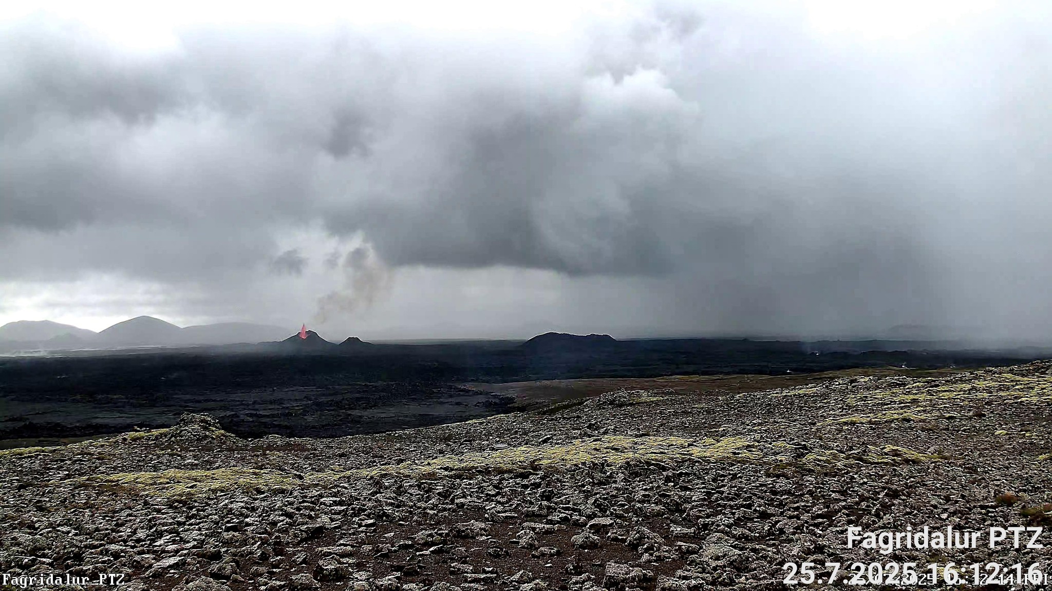
Eruption ongoing on the Sundhnúkur crater row . Updated 11:45, 25 July
Reduced Volcanic Activity but Continued Lava Flow and Thickening
Volcanic activity has decreased since yesterday morning but has remained stable since then.
Lava continues to flow east and southeast, spreading within one kilometre of the main crater.
Little movement is observed at the outer edges of the lava field, and the lava is mostly thickening.
Seismic tremor has fluctuated in recent days, likely due to alternating buildup and collapse within the crater.
A thin crust has formed on top of the lava, which may suddenly break and cause rapid lava advancement without warning.
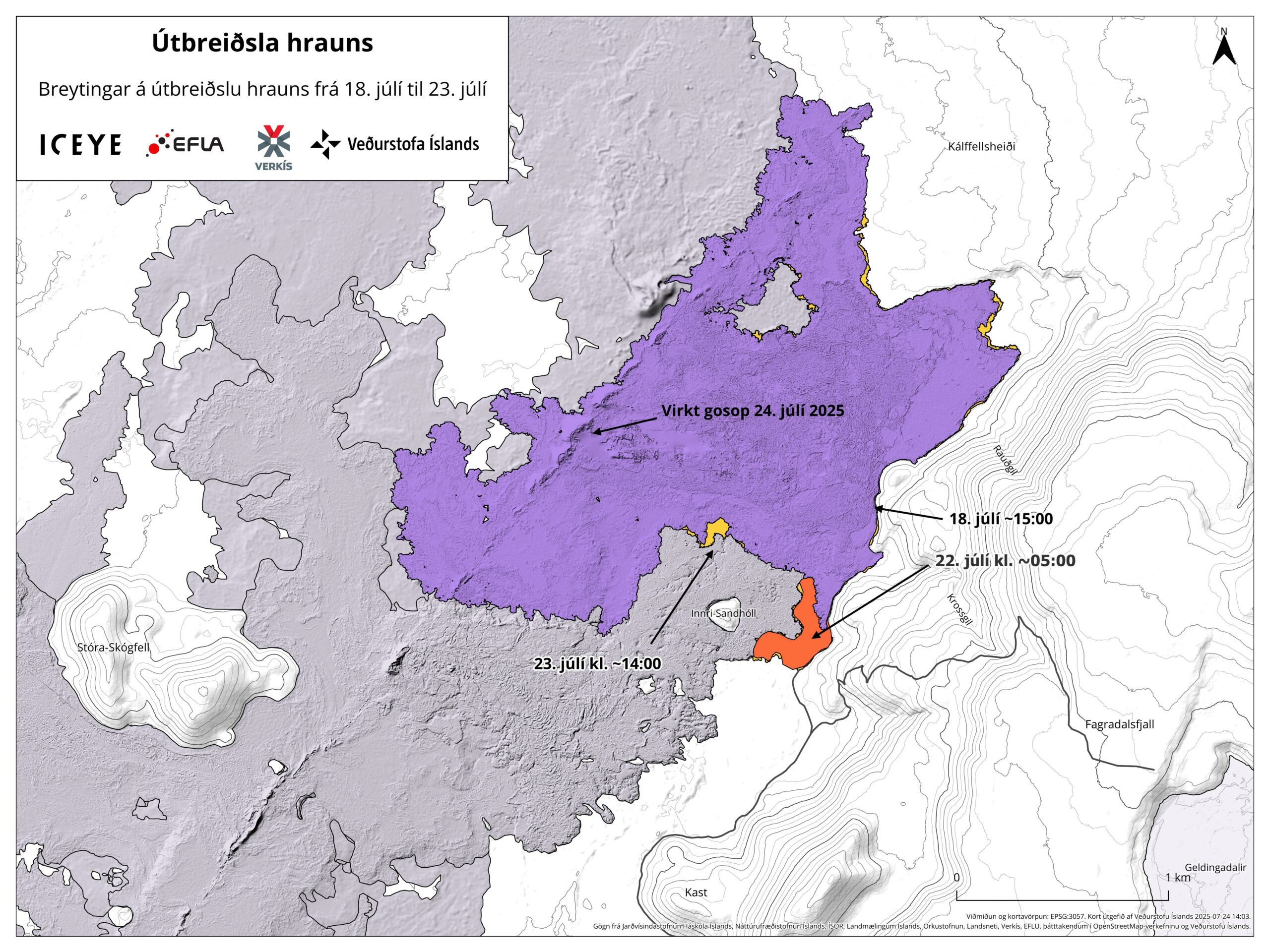
The highest hazard is considered to be in the southern part of the lava field, near Sandhóll.
Deformation measurements show no changes beneath Svartsengi – magma inflow and outflow appear to be in balance.
A new hazard assessment map is in effect until July 29, with the next scheduled update also on that date
Volcanic activity has decreased since yesterday morning but has remained relatively stable since then, with continued lava flow to the east and southeast from the main crater. The lava is spreading over an area within one kilometer of the crater, and movement at the outermost lava fronts is minimal.
Tremor has fluctuated considerably in recent days, likely due to alternating phases of crater buildup and collapse. Experts caution against overinterpretation, as weather conditions and surface movement within the lava field can influence measurements.
Despite the recent decline in eruptive activity, lava continues to flow eastward from the crater. The lava field covers a large area and is mostly thickening. A thin crust has formed on top of the flowing lava, which may rupture suddenly and cause rapid lava surges without warning. It is therefore crucial to maintain a safe distance from the lava, and any visits near the site should take this hazard into account. This danger is especially present in the southern part of the lava field, near Sandhóll.
Ground deformation measurements indicate no changes in recent days, with no signs of uplift or subsidence beneath Svartsengi. This suggests that magma inflow and outflow within the system are currently in equilibrium and that the eruption is being sustained by magma ascending from deeper layers of the crust.
The map below shows how the outlines of the new lava field changed between July 18 and July 23. These outlines are based on ICEYE satellite images and drone measurements. Most of the lava has flowed southeast toward Fagradalsfjall and has gradually filled depressions along the base of the mountain, both to the north and south.
The weather forecast predicts southeasterly and easterly winds today, meaning that gas pollution will drift northwest and west. As a result, pollution may be detected in the northwestern and western parts of the Reykjanes Peninsula. Later in the evening, winds will shift to a northwesterly direction, potentially bringing pollution to Grindavík. Wind speeds are expected to increase on Reykjanes in the afternoon of July 26, carrying pollution toward the southeast. Very little to no volcanic haze was detected overnight.
Source et photos : IMO .
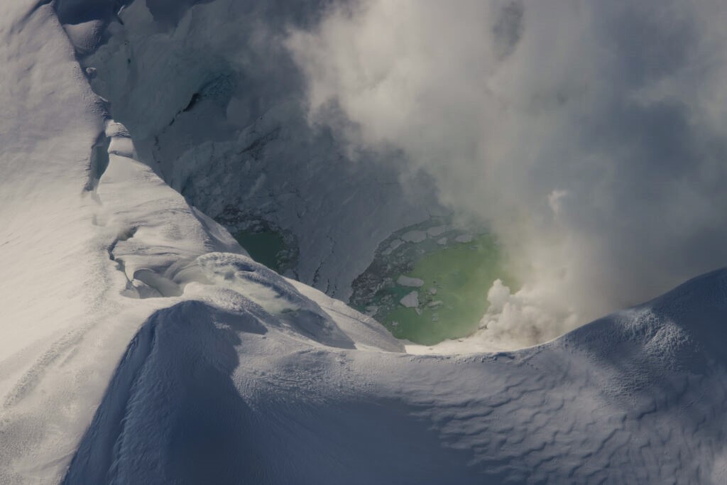
Alaska , Spurr :
Unrest continues to decline at Mount Spurr. The decrease in activity suggests that the magma intrusion beneath Mount Spurr has stalled, and the likelihood of an eruption has declined.
Earthquake activity continues, but a majority of the seismicity near Mount Spurr is non-volcanic as part of a small swarm related to glacial activity at Pothole Glacier 10 – 15 km (6 – 9 miles) to the west. Only about 39 earthquakes (all with a magnitude less than 2.0) were located close to the summit of Mount Spurr or Crater Peak. The number of earthquakes and their magnitudes continue to vary from week to week but follow an overall decreasing trend. Ground deformation, as measured by GNSS (GPS) stations, remains paused as it has been since about mid-March 2025. Volcanic gas emissions continue, as would be expected from a passively degassing body of stalled magma.
Fluctuations in unrest are common at volcanoes and eruptive activity remains possible, but unlikely. Should unrest escalate towards an eruption, we expect to observe increases in seismic activity, gas emissions, surface deformation, and surface heating.
AVO continues to closely monitor activity at Mount Spurr using local seismic, infrasound, and GNSS (GPS) stations, web cameras, airborne and satellite gas measurements, regional infrasound, lightning networks, and satellite images.
Source : AVO
Photo : Mitchell, Mitch / AVO/USGS
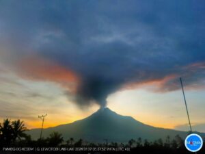
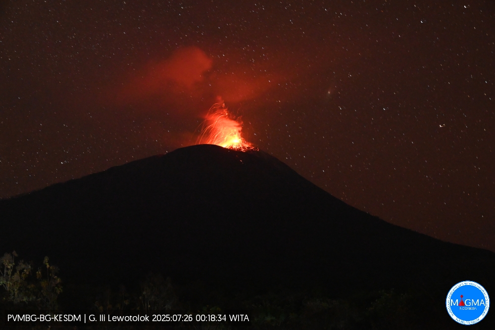
Indonesia , Ili Lewotolok :
An eruption of Mount Ili Lewotolok occurred on Saturday, July 26, 2025, at 00:18 WITA. An ash column was observed about 200 m above the summit (about 1,623 m above sea level). The ash column was white to gray in color, moderate in intensity, and directed westward. This eruption was recorded by seismograph with a maximum amplitude of 20.2 mm and a duration of 53 seconds.

Seismic Observations
34 eruption earthquakes with amplitudes ranging from 7.8 to 32.7 mm and durations ranging from 37 to 59 seconds.
20 emission earthquakes with amplitudes ranging from 1.6 to 5.8 mm and durations ranging from 28 to 40 seconds.
1 local tectonic earthquake with an amplitude of 1.5 mm and duration of 21 seconds.
Recommendations
At Activity Level III (SIAGA):
Residents of Mount Ili Lewotolok, as well as visitors, climbers, and tourists, are advised to refrain from entering or carrying out activities within a 3 km radius of the activity center of Mount Ili Lewotolok. Be aware of the potential dangers of lava avalanches and pyroclastic flows originating from the southern, southeastern, western and northeastern sectors of Mount Ili Lewotolok.
Source et photo : Magma Indonésie .
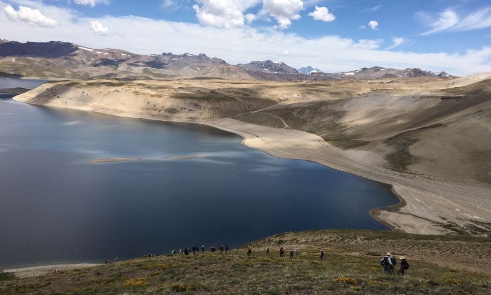
Chile , Laguna del Maule :
Special Report on Volcanic Activity (REAV), Maule Regions, Laguna del Maule Volcanic Complex, July 26, 2025, 1:15 a.m. local time (Continental Chile)
The National Geology and Mining Service of Chile (Sernageomin) announces the following preliminary information, obtained using the monitoring equipment of the National Volcanic Monitoring Network (RNVV), processed and analyzed at the Southern Andean Volcano Observatory (OVDAS):
On Friday, July 26, 2025, at 10:00 p.m. (July 26, 2:00 a.m. UTC), monitoring stations installed near the Laguna del Maule volcanic complex recorded an increase in the occurrence of volcano-tectonic earthquakes (associated with rock fracturing within the volcanic system), reaching a total of 102 earthquakes in the last three hours. characterizing this seismic episode as a swarm of earthquakes.
The characteristics of the highest-energy earthquake, after analysis, are as follows:
TIME OF ORIGIN: 00:20 local time (04:20 UTC)
LATITUDE: 36.094° S
LONGITUDE: 70.573° W
DEPTH: 6.3 km
LOCAL MAGNITUDE: 1.4 (ML)
Observation:
The current activity is characterized by abundant volcano-tectonic (VT) seismicity, a situation that has persisted for several days. It is expected that, under current conditions, this activity will continue to be recorded, as it has been developing for several months.
The Volcanic Technical Alert remains at GREEN.
Source : Sernageomin
Photo : auteur inconnu.
Guatemala , Santiaguito :
Activity
Weak to moderate degassing, consisting of water vapor and other magmatic gases, is observed above the Caliente Dome, rising up to 700 meters above sea level. This activity is sometimes accompanied by jet sounds audible in surrounding communities and farms. Moderate degassing pulses and small explosions can increase the height of the ash and gas column up to 1,000 meters above the dome.
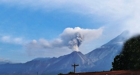
Incandescent blocks of rock are also occasionally observed falling toward the west, southwest, and south flanks. Due to wind direction, fine ash particles may fall on Loma Linda and the surrounding area. Due to the accumulation of rock material on Caliente Dome and the promontory overlooking the lava flow on its southwest flank, it may collapse and generate long-range density pyroclastic currents toward the southwest, south, southeast, and northeast. Follow the recommendations in bulletin BESAN-002-2025.
Source : Insivumeh .
Photo : Conred.