July 15 , 2025.
Indonesia , Ibu :
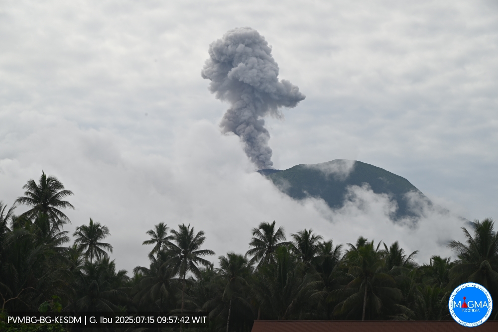
Mount Ibu erupted on Tuesday, July 15, 2025, at 9:57 a.m. (local time). An ash column was observed about 800 m above the summit (about 2,125 m above sea level). The ash column was gray and of strong intensity, oriented northwest. This eruption was recorded by seismograph with a maximum amplitude of 28 mm and a duration of 52 seconds.
VOLCANO OBSERVATORY NOTICE FOR AVIATION – VONA
Issued : July 15 , 2025
Volcano : Ibu (268030)
Current Aviation Colour Code : ORANGE
Previous Aviation Colour Code : orange
Source : Ibu Volcano Observatory
Notice Number : 2025IBU914
Volcano Location : N 01 deg 29 min 17 sec E 127 deg 37 min 48 sec
Area : North Maluku, Indonesia
Summit Elevation : 4240 FT (1325 M)

Volcanic Activity Summary :
Eruption with volcanic ash cloud at 00h57 UTC (09h57 local).
Volcanic Cloud Height :
Best estimate of ash-cloud top is around 6800 FT (2125 M) above sea level or 2560 FT (800 M) above summit. May be higher than what can be observed clearly. Source of height data: ground observer.
Other Volcanic Cloud Information :
Ash cloud moving to northwest. Volcanic ash is observed to be gray. The intensity of volcanic ash is observed to be thick.
Remarks :
Eruption recorded on seismogram with maximum amplitude 28 mm and maximum duration 52 second.
Source et photo : Magma Indonésie .
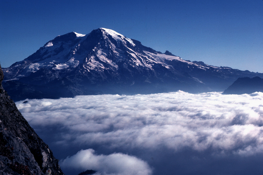
United – States , Mount Rainier :
CASCADES VOLCANO OBSERVATORY STATUS REPORT , U.S. Geological Survey
Monday, July 14, 2025, 11:43 AM PDT (Monday, July 14, 2025, 18:43 UTC)
46°51’11 » N 121°45’36 » W,
Summit Elevation 14409 ft (4392 m)
Current Volcano Alert Level: NORMAL
Current Aviation Color Code: GREEN
This is an update on the ongoing seismic swarm at Mount Rainier that began at 1:29 AM PDT (8:29 UTC) on July 8th.
Swarm event rates continue to decline. As of 11 AM PDT (18:00 UTC) on July 15th, the Cascades Volcano Observatory (CVO) and the Pacific Northwest Seismic Network (PNSN) have located 540 events since the start of the swarm, although many more have occurred but cannot be located. The largest event of the swarm so far was a magnitude 2.4 that occurred on July 11th at 12:23 PM PDT (19:23 UTC). Seismicity has decreased from 33 located events per hour at the swarm’s peak on the morning of July 8th to a couple events per hour as of Monday morning. The earthquakes are mainly spread between 1.5-4 miles (2-6 km) beneath the summit. There have been no changes in ground deformation or other monitoring data.
The cause of the swarm remains consistent with the circulation of fluids along preexisting faults beneath the volcano, which is considered background activity at Mount Rainier. There is currently no indication that the swarm is associated with magmatic unrest.
Due to the waning nature of the swarm, this will be the last daily status update unless there are significant changes in the characteristics of the seismicity. Rainier activity will be summarized in the weekly CVO update, which is posted every Friday.
PNSN and CVO will continue to monitor activity, locate earthquakes, and provide additional information as needed.
About Mount Rainier
Mount Rainier is an active, ice-clad stratovolcano geographically located within the Mount Rainier National Park. Mount Rainier is located about 45 miles (73 km) southeast of Tacoma and 60 miles (97 km) south-southeast of Seattle in Washington State. It is the tallest peak in the Cascade Range and is covered by the greatest concentration of glaciers in the contiguous United States.
Source : CVO.
Photo : Lee Siebert, 1981 (Smithsonian Institution).
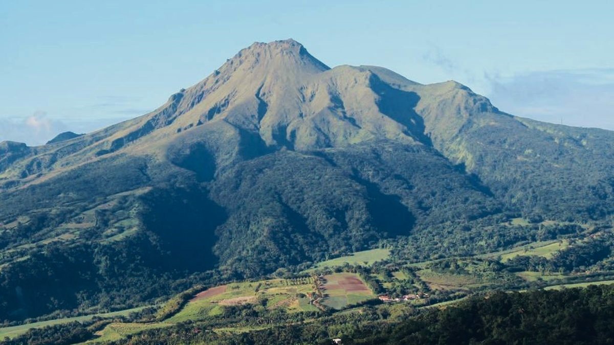
La Martinique , Mount Pelée :
Weekly Report, Paris Institute of Earth Physics / Martinique Volcanological and Seismological Observatory
Saint-Pierre, July 11, 2025, at 2:15 p.m. local time (GMT-4)
Volcanic activity decreased slightly this week, with 59 earthquakes of volcanic origin observed.
Between July 4, 2025, at 4:00 p.m. (UT) and July 11, 2025, at 4:00 p.m. (UT), the OVSM recorded:
• 57 low-energy volcano-tectonic earthquakes. These earthquakes were clearly identified as originating from one of the well-known seismically active zones on Mount Pelée,
located between 1.0 and 1.4 km deep below the volcano’s summit. The superficial volcano-tectonic seismicity is associated with micro-fracturing in the volcanic edifice linked to the global reactivation of the volcano observed since the end of 2018.
• Two long-period earthquakes were preliminarily located, both approximately 5 km southeast of Mount Pelée, at depths of approximately 17 and 29 km, with magnitudes Mlv=0.70 and Mlv=0.71, respectively. Long-period deep earthquakes contain only low frequencies and are associated with the circulation of magmatic fluids deep within Mount Pelée’s volcanic system.
No earthquakes were felt by the population.
The previous week, the OVSM recorded 118 volcanic earthquakes. As of July 11, 2025, and over the past four weeks, the OVSM has observed a total of 271 volcanic earthquakes, an average of 67 to 68 earthquakes per week. During phases of volcanic reactivation in volcanoes similar to Mount Pelée, seismic activity of varying intensity and frequency is commonly observed.
For more details on observations and interpretations of volcanic activity over the longer term, refer to the OVSM monthly bulletins.
The alert level is currently YELLOW: vigilance.
Source : Direction de l’OVSM-IPGP.
Photo : OVSM.
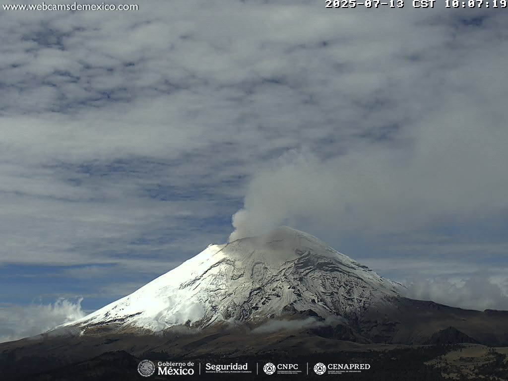
Mexico , Popocatepetl :
July 14, 11:00 a.m. (July 14, 5:00 p.m. GMT)
Activity in the past 24 hours
Thirty low-intensity exhalations, accompanied by water vapor, other volcanic gases, and small amounts of ash, were detected. In addition, 1,093 minutes of low-amplitude tremor segments were recorded, including 963 minutes of high-frequency tremor and 130 minutes of harmonic tremor.
During the morning and at the time of writing, a continuous emission of water vapor and volcanic gases was observed, dispersing towards the northwest (NW).
The Popocatépetl volcano alert level is at Yellow Phase 2.
The expected scenarios for this phase are as follows:
A few minor to moderate explosions
Occurrence of tremors of varying amplitude
Light to moderate ashfall in surrounding towns and some more distant towns
Expulsion of incandescent fragments within a 12-kilometer exclusion radius
Lahars descending into ravines are expected due to ash accumulation on the slopes and their interaction with the precipitation expected in the coming weeks
Possibility of pyroclastic flows not reaching towns
Source et photo : Cenapred .
Guatemala , Fuego :
Weather: Clear
Wind: East
Precipitation: 0.0 mm

Activity
The Fuego Volcano Observatory reports volcanic activity characterized by degassing generating a gray fumarole at an altitude of 500 meters above the crater, dispersing westward. However, weak to moderate explosions can occur during the day. Residual blocks from the June 5 eruption have been observed, which could descend by gravity in the form of light avalanches. Wind can also move fine sediments towards communities near the volcano. These deposits can be carried away in the form of lahars or torrents by precipitation. It is therefore recommended not to stay in or near the volcano’s ravines. The recommendations of special bulletin BEFGO-013-2025 should be followed.
Source : Insivumeh .
Photo : Conred