July 9 , 2025.
Italy / Sicily , Etna :
WEEKLY BULLETIN, from June 30, 2025 to July 6, 2025. (Publication date: July 8, 2025)
ACTIVITY SUMMARY
Monitoring data include the following:
1) VOLCANOLOGICAL OBSERVATIONS: Variable-rate degassing in summit craters.
2) SEISMOLOGY: Low seismic activity due to fracturing. Tremor amplitude is low.
3) INFRASOUND: Infrasound activity is predominantly medium-intensity.
4) GROUND DEFORMATION: Ground deformation monitoring networks have not recorded any significant changes.
5) GEOCHEMISTRY: Medium-to-low SO2 fluxes.
Ground CO2 fluxes (EtnaGas Network): Increase from low to medium values. Dissolved CO2 in groundwater (EtnaWater Network): No update. Helium isotope ratio at peripheral sites: No update; the latest data were at average values (June 4).
6) SATELLITE OBSERVATIONS: Thermal activity observed by satellite in the summit area was generally low.
EXPECTED SCENARIOS
Frequent explosive activity in the summit craters, with the formation of ash clouds and fallout of coarse pyroclastic debris, accompanied by lava emissions in the summit area. A rapid evolution of the ongoing phenomena towards more intense activity, with the formation of eruptive columns, ash clouds, and collapse of portions of the summit cones, with the formation of pyroclastic flows, cannot be ruled out.
VOLCANOLOGICAL OBSERVATIONS
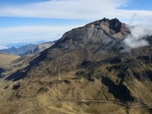
Volcanic activity at Mount Etna was monitored by analyzing images from the INGV surveillance camera network, Osservatorio Etneo (INGV-OE). During the week in question, the summit craters were affected by degassing at varying rates, mainly affecting the Northeast Crater and, to a lesser extent, the Southeast and Bocca Nuova Craters. Periodically, people on the rim of the northeast crater have heard faint explosions coming from the vent at the crater floor.
Source : INGV
Photo : Gio Giusa .
Italy , Stromboli :
WEEKLY BULLETIN, from June 30, 2025 to July 6, 2025. (Publication date: July 8, 2025)
ACTIVITY SUMMARY
Monitoring data include the following:
1) VOLCANOLOGICAL OBSERVATIONS: Ordinary eruptive activity with a medium total frequency of Strombolian explosions in the northern area and low intensity. Degassing activity and no explosive activity in the central-southern area.
2) Seismology: The monitored seismological parameters show no significant variations.
3) Ground deformation: Ground deformation monitoring networks showed no significant variations.
4) GEOCHEMISTRY: Average SO2 flux. CO2 flux from the soil in the Pizzo area (STR02) with high values. C/S ratio in the plume: average values.
Helium isotope ratio (R/Ra) dissolved in the thermal aquifer: no update.
CO2 flux in the soil of the San Bartolo area: no update.
CO2 flux in the soil of the Scari area: average to high values.
5) SATELLITE OBSERVATIONS: Thermal activity observed by satellite in the summit area was generally low.
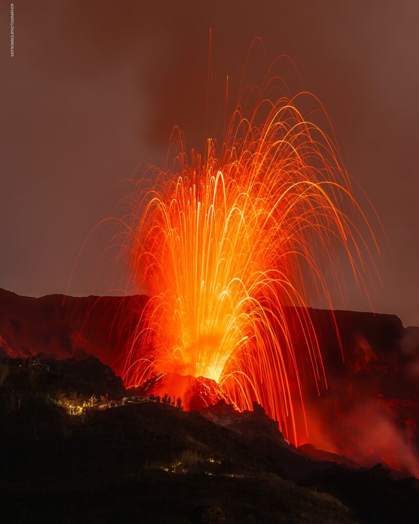
VOLCANOLOGICAL OBSERVATIONS
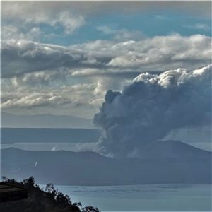
During the observation period, Stromboli’s eruptive activity was characterized by analyzing images recorded by the INGV-OE surveillance cameras located at 190 m (SCT-SCV) and at Punta dei Corvi (SPCT). Explosive activity was produced by four (4) eruptive vents located in the North Crater area. In the South-Central area, however, degassing activity was observed at varying rates, with no evidence of explosive episodes.
Observations of explosive activity captured by surveillance cameras
Eruptive activity during the period was localized in the North (N) Crater area, notably by four active vents that fueled low-intensity activity (heights less than 80 m) and episodic activity of medium intensity (heights less than 150 m). The average explosion frequency ranged from 3 to 13 events per hour. The eruption products consisted mainly of coarse materials (bombs and lapilli). No explosive activity was observed in the Central-South (CS) area.
Source : INGV
Photo : Stromboli stati d’animo / Sebastiano Cannavo .
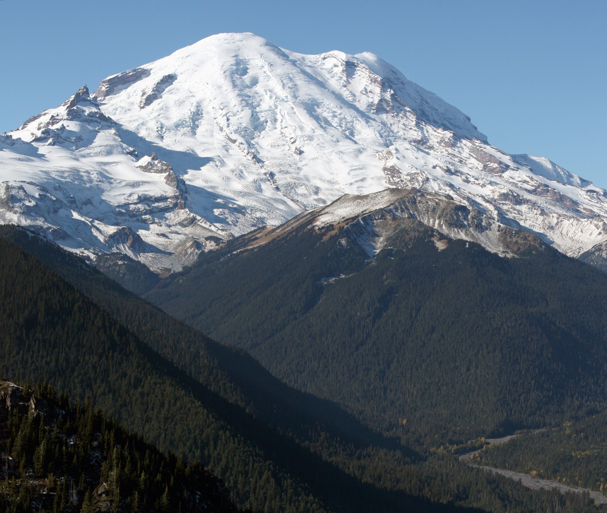
United -States , Mount Rainier :
CASCADES VOLCANO OBSERVATORY INFORMATION STATEMENT , U.S. Geological Survey
Tuesday, July 8, 2025, 9:26 AM PDT (Tuesday, July 8, 2025, 16:26 UTC)
46°51’11 » N 121°45’36 » W,
Summit Elevation 14409 ft (4392 m)
Current Volcano Alert Level: NORMAL
Current Aviation Color Code: GREEN
On July 8, 2025, the U.S. Geological Survey Cascades Volcano Observatory (CVO) and Pacific Northwest Seismic Network (PNSN) detected a swarm of earthquakes at Mount Rainier starting at 01:29 PDT (08:29 UTC). So far, hundreds of earthquakes have been detected with event rates up to several per minute, ranging from depths of 1.2 – 3.7 miles (2-6 km) below the summit. The largest earthquake located thus far is a magnitude 1.7.
Currently, there is no indication that the level of earthquake activity is cause for concern, and the alert level and color code for Mount Rainier remain at GREEN / NORMAL.
Recent activity
Beginning at about 1:29 AM PDT (8:29 UTC) on July 8, a swarm of small earthquakes began near the summit of Mount Rainier. The Pacific Northwest Seismic Network is locating earthquakes with the largest so far being a M1.7 at 04:52 PDT (11:52 UTC), ranging from depths of 1.2 – 3.7 miles (2-6 km) below the summit. There are hundreds of small earthquakes occurring at rates of up to several per minute at times. No earthquakes have been felt at the surface.
Instruments do not show any detectable ground deformation at the volcano, and no anomalous signals have been seen on the infrasound monitoring stations. Mount Rainier does not have a dedicated continuous volcanic gas sampling capability.
Typically, earthquakes at this volcano are located at a rate of about 9 earthquakes per month. Swarms typically occur 1-2 times per year, but are usually much smaller in terms of number of events. The last large swarm at Mount Rainier in 2009 had a maximum magnitude of M2.3 and lasted three days. The 2009 swarm had over 1000 earthquakes, of which the PNSN officially located 120 earthquakes. Past swarms have been attributed to circulation of fluids interacting with preexisting faults.
About Mount Rainier
Mount Rainier is an active, ice-clad stratovolcano geographically located within the Mount Rainier National Park. Mount Rainier is located about 45 miles (73 km) southeast of Tacoma and 60 miles (97 km) south-southeast of Seattle in Washington State. It is the tallest peak in the Cascade Range and is covered by the greatest concentration of glaciers in the contiguous United States.
Source : CVO
Photo : Walter Siegmund / wikipedia.
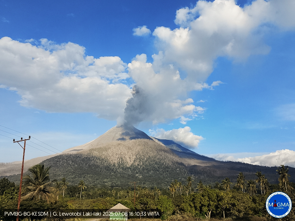
Indonesia , Lewotobi Laki-laki :
An eruption of Mount Lewotobi Laki-laki occurred on Tuesday, July 8, 2025, at 4:08 PM WITA. The observed ash column was ± 1,200 m above the summit (± 2,784 m above sea level). The ash column was gray and of strong intensity, oriented towards the West and Northwest. This eruption was recorded by seismograph with a maximum amplitude of 4.4 mm and a duration of 54 seconds.
VOLCANO OBSERVATORY NOTICE FOR AVIATION – VONA
Issued : July 8 , 2025
Volcano : Lewotobi Laki-laki (264180)
Current Aviation Colour Code : ORANGE
Previous Aviation Colour Code : orange
Source : Lewotobi Laki-laki Volcano Observatory
Notice Number : 2025LWK351
Volcano Location : S 08 deg 32 min 20 sec E 122 deg 46 min 06 sec
Area : East Nusa Tenggara, Indonesia
Summit Elevation : 5069 FT (1584 M)
Volcanic Activity Summary :
Eruption with volcanic ash cloud at 08h08 UTC (16h08 local).
Volcanic Cloud Height :
Best estimate of ash-cloud top is around 8909 FT (2784 M) above sea level or 3840 FT (1200 M) above summit. May be higher than what can be observed clearly. Source of height data: ground observer.
Other Volcanic Cloud Information :
Ash cloud moving from west to northwest. Volcanic ash is observed to be gray. The intensity of volcanic ash is observed to be thick.
Remarks :
Eruption recorded on seismogram with maximum amplitude 4.4 mm and maximum duration 54 second.
Source et photo : Magma Indonésie .
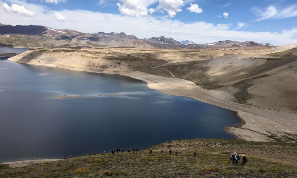
Chile , Laguna del Maule :
Special Report on Volcanic Activity (REAV), Maule Regions, Laguna del Maule Volcanic Complex, July 8, 2025, 10:44 PM local time (Continental Chile)
The National Geology and Mining Service of Chile (SERNAGEOMIN) announces the following preliminary information, obtained using the monitoring equipment of the National Volcanic Monitoring Network (RNVV), processed and analyzed at the Southern Andean Volcano Observatory (OVDAS):
On Tuesday, July 8, 2025, at 10:20 PM (Wednesday, July 9, 2:20 AM UTC), monitoring stations installed near the Laguna del Maule volcanic complex recorded an increase in the occurrence of volcano-tectonic earthquakes (associated with rock fracturing within the volcanic system), reaching a total of 100 earthquakes in the last few hours. characterizing this seismic episode as a swarm of earthquakes.
The characteristics of the highest-energy earthquake after its analysis are as follows:
TIME OF ORIGIN: 8:04 PM local time (00:04 UTC)
LATITUDE: 36.115°S
LONGITUDE: 70.587°W
DEPTH: 4.8 km
LOCAL MAGNITUDE: 1.3 (ML)
Observation:
At the time of this report, volcano-tectonic events continue to be recorded at the Laguna del Maule volcanic complex. This activity has been ongoing for the past few days, primarily with low- and moderate-energy earthquakes, with similar epicenters to the south-southwest of the southern part of the lagoon. This activity is likely to persist, with events of similar characteristics, in the coming days.
The technical volcanic alert remains at GREEN.
Source : Sernageomin
Photo : auteur inconnu