July 6 , 2025.
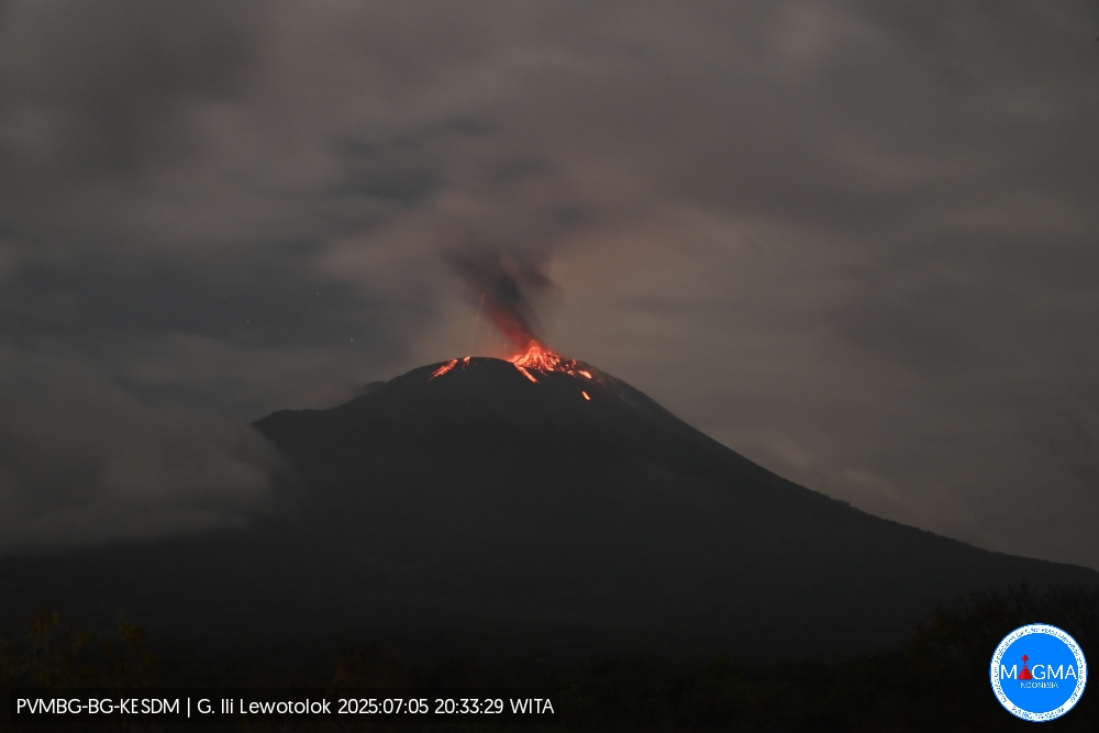
Indonesia , Ili Lewotolok :
An eruption of Mount Ili Lewotolok occurred on Saturday, July 5, 2025, at 21:53 UTC (05:53 local time). The observed ash column was ± 500 m above the summit (± 6,154 ft above sea level). The ash column was black and of strong intensity, oriented towards the west and northwest. This eruption was recorded by seismograph with a maximum amplitude of 40 mm and a duration of 26 seconds.
VOLCANO OBSERVATORY NOTICE FOR AVIATION – VONA
Issued : July 5 , 2025
Volcano : Ili Lewotolok (264230)
Current Aviation Colour Code : ORANGE
Previous Aviation Colour Code : orange
Source : Ili Lewotolok Volcano Observatory
Notice Number : 2025LEW045
Volcano Location : S 08 deg 16 min 19 sec E 123 deg 30 min 18 sec
Area : East Nusa Tenggara, Indonesia
Summit Elevation : 4554 FT (1423 M)
Volcanic Activity Summary :
Eruption with volcanic ash cloud at 21h53 UTC (05h53 local).
Volcanic Cloud Height :
Best estimate of ash-cloud top is around 6154 FT (1923 M) above sea level or 1600 FT (500 M) above summit. May be higher than what can be observed clearly. Source of height data: ground observer.
Other Volcanic Cloud Information :
Ash cloud moving from west to northwest. Volcanic ash is observed to be gray to dark. The intensity of volcanic ash is observed to be thick.
Remarks :
Eruption recorded on seismogram with maximum amplitude 40 mm and maximum duration 28 second.
Source et photo : Magma Indonésie .
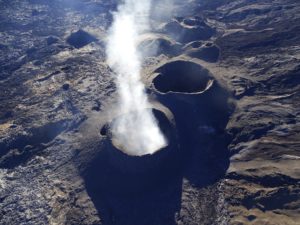
Chile , Lascar :
Seismology
Seismological activity during this period was characterized by:
18 VT-type seismic events, associated with rock fracturing (volcano-tectonics). The most energetic earthquake, with a local magnitude (LM) of 1.7, was located 0.6 km east-southeast of the volcanic edifice, at a depth of 1.9 km.
19 LP-type seismic events, associated with fluid dynamics within the volcanic system (long period). The magnitude of the largest earthquake, estimated using the reduced displacement (RD) parameter, was 7 cm².
Fluid Geochemistry
Sulfur dioxide (SO2) emission data obtained using Differential Optical Absorption Spectroscopy (DOAS) equipment at the Emu station, located 6 km east-southeast of the active crater, showed an average SO2 flux of 1,473 t/d for the period under review, with a maximum daily value of 2,943 t/d on June 16. These values are believed to be due to a seasonal effect, with high wind speeds affecting measurements of this gas.
In addition, an anomaly in sulfur dioxide (SO2) emissions into the atmosphere was reported in the area near the volcanic complex on June 29, according to data published by the Tropospheric Monitoring Instrument (TROPOMI) and the Sulfur Dioxide Monitoring Group of the Ozone Monitoring Instrument (OMI).
Satellite Thermal Anomalies
During this period, 20 thermal anomalies were detected in the volcanic area, according to the MIROVA platform. The highest thermal energy recorded was 1.8 MW on June 17 (according to the MODIS sensor) and 2.8 MW on June 20 (according to the VIIRS sensor). During the fortnight, a Sentinel 2-L2A satellite image was available on June 16. Processed in false-color bands, it allows us to observe variations in the thermal configuration inside the crater, mainly with two areas of anomalous thermal radiance. Furthermore, the NHI platform (Normalized Hotspot Indices, Marchese et al., 2019) estimated a total radiance area (hotspot) of 5,400 m² on June 24, a value considered moderate. A downward trend in the value of thermal anomalies is observed, to a level considered low.
Geodesy
The geodetic activity during the period was characterized by:
– Low magnitude rates of the horizontal components of the GNSS stations
– Low amplitude variations (< 0.3 cm/month) of the vertical components at the two GNSS monitoring stations, unrelated to changes in the volcano’s internal dynamics.
– Low amplitude extension/contraction rates of the monitoring line, not exceeding 0.2 cm/month.
– No changes in radar interferometry for the short-term (6 days) and medium-term (6 months) interferograms.
Therefore, the system is geodetically stable.
Surveillance Cameras
Surveillance cameras installed near the volcano, when weather conditions permitted, recorded columns of whitish gas moving east and southeast. The maximum reached 420 meters above the crater on June 23. No incandescence was observed during the assessed period.
Satellite Geomorphological Analysis
According to Planet Scope Scene satellite images, no morphological variations were identified in the active crater.
Activity remained at levels considered low, suggesting the volcano’s stability.
The Volcanic Technical Alert remains in effect at:
GREEN TECHNICAL ALERT: Active Volcano with Stable Behavior – No Immediate Risk
Note:
Given the behavior of this volcanic system observed over the past ten years, sudden, unpredictable, low-magnitude explosions affecting the immediate vicinity of the active crater cannot be ruled out. However, given its baseline level, this type of event has not been frequent; its probability of occurrence is therefore considered low. Risks associated with this minor activity include the ejection of ballistic pyroclasts, ash emission, and volcanic gas emission.
Source et photo : Sernageomin
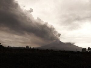
Ecuador , Sangay :
DAILY STATUS REPORT OF SANGAY VOLCANO, Saturday, July 5, 2025.
Information Geophysical Institute – EPN.
Surface Activity Level: High, Surface Trend: No Change
Internal Activity Level: Moderate, Internal Trend: No Change
Seismicity: From July 4, 2025, 11:00 a.m. to July 5, 2025, 11:00 a.m.:
Seismicity:
Below is the count of seismic events recorded at the reference station.
Explosion (EXP): 59

Rainfall/Lahars:
Since yesterday afternoon, no rain has been recorded in the volcano area. **Heavy rains could remobilize accumulated material, generating mud and debris flows that would cascade down the volcano’s flanks and flow into adjacent rivers**.
Emission/Ash Column:
Yesterday afternoon, due to weather conditions, surface activity could not be recorded by surveillance cameras and satellites. The Washington VAAC Agency issued a report of an ash cloud drifting westward at a height of 1,500 meters above the crater.
Other Monitoring Parameters:
The FIRMS and MIROVA-VIIRS 375 satellite systems recorded a thermal anomaly and a weak thermal anomaly over the past 24 hours.
Note:
From yesterday afternoon until the closing of this report, the volcano remained mostly cloudy.
Alert Level: Yellow
Source : IGEPN
Photo : volcanian / dparedesb
Colombia , Nevado del Ruiz :
Manizales, July 1, 2025, 4:30 p.m.
Regarding the monitoring of the activity of the Nevado del Ruiz volcano, the Colombian Geological Survey (SGC), an entity affiliated with the Ministry of Mines and Energy, reports that:
From June 24 to 30, 2025, the volcano continued to exhibit unstable behavior. Compared to the previous week, the main variations in the monitored parameters were:
– Seismic signals related to fluid dynamics in volcanic conduits increased, both in terms of the number of recorded events and the seismic energy released. The energy levels of these signals were generally low, sometimes moderate. However, a high energy value was recorded on June 27, associated with a short-lived signal that occurred at 8:00 p.m. This value corresponds to the highest recorded since the beginning of the year and since December 24, 2024, when a similar level was reached. Cameras (conventional or thermographic) used to monitor the volcano confirmed pulsed ash emissions associated with these signals. However, confirmation of this phenomenon, as well as the apparent temperature variations of the emitted materials, remained limited due to persistent cloudy atmospheric conditions in the region.

– Seismic activity associated with rock fracturing processes within the volcanic edifice decreased in the number of recorded events and slightly increased in the seismic energy released. The seismic events were located in the Arenas crater and on the east, northeast, north, southeast, south, and southwest flanks of the volcano, within 5 km of the crater. The depth of the earthquakes ranged from less than 1 km to 7 km from the volcanic summit. The highest magnitude of the week was 1.3, corresponding to the earthquake recorded on June 28 at 8:21 a.m., located 2 km southeast of the crater, at a depth of 3 km.
– Water vapor and gas emissions, mainly sulfur dioxide (SO2), into the atmosphere from the Arenas crater were variable. Daily SO2 fluxes increased compared to the previous week. Satellite monitoring, carried out to complement the assessment of this parameter, continues to show SO2 emissions.
– The height of the gas, ash, and water vapor column remained below 900 m above the volcano’s summit. It should be noted, however, that this estimate is conditioned by the high cloudiness of the area. The plume dispersion direction showed a predominant trend toward the northwest and west flanks of the volcano. Due to these wind directions, sulfur odors were reported on the morning of June 28 in the Valle de las Tumbas sector, in Los Nevados National Natural Park. While monitoring thermal anomalies at the floor of the Arenas crater, satellite monitoring platforms recorded some reports of low energy levels, although detection was limited by the high cloudiness of the volcanic area.
Source et photo : SGC.
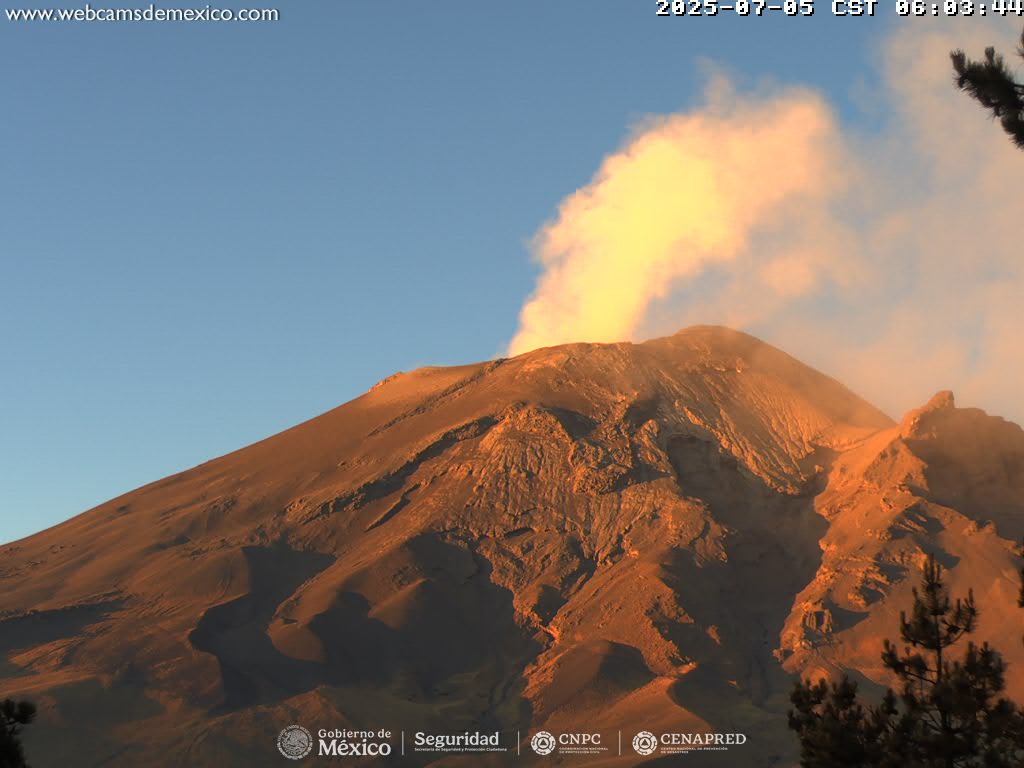
Mexico : Popocatepetl :
July 5, 11:00 a.m. (July 5, 5:00 p.m. GMT)
Activity in the past 24 hours
Thirty-one low-intensity exhalations accompanied by water vapor and other volcanic gases were detected. In addition, 845 minutes of low-amplitude tremor were recorded, including 616 minutes of high-frequency tremor and 229 minutes of harmonic tremor.
At the time of writing, an emission of water vapor and other volcanic gases is observed, dispersing in a west-northwest direction.
The Popocatépetl volcano fire alert is at yellow phase 2.
The expected scenarios for this phase are as follows:
A few minor to moderate explosions
Occurrence of tremors of varying amplitude
Light to moderate ashfall in surrounding towns and some more distant towns
Expulsion of incandescent fragments within a 12-kilometer exclusion radius
Lahars descending into ravines are expected due to ash accumulation on the slopes and its interaction with the precipitation expected in the coming weeks
Possibility of pyroclastic flows not reaching towns
Source et photo : Cenapred.