June 31 , 2025.
Hawaii , Kilauea :
HVO/USGS Volcanic Activity Notice
Current Volcano Alert Level: WATCH
Current Aviation Color Code: ORANGE
Issued: Sunday, June 29, 2025, 8:20 PM HST
Source: Hawaiian Volcano Observatory
Notice Number: 2025/H302
Location: N 19 deg 25 min W 155 deg 17 min
Elevation: 4091 ft (1247 m)
Area: Hawaii
Volcanic Activity Summary:
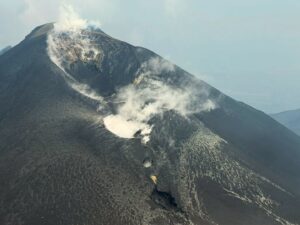
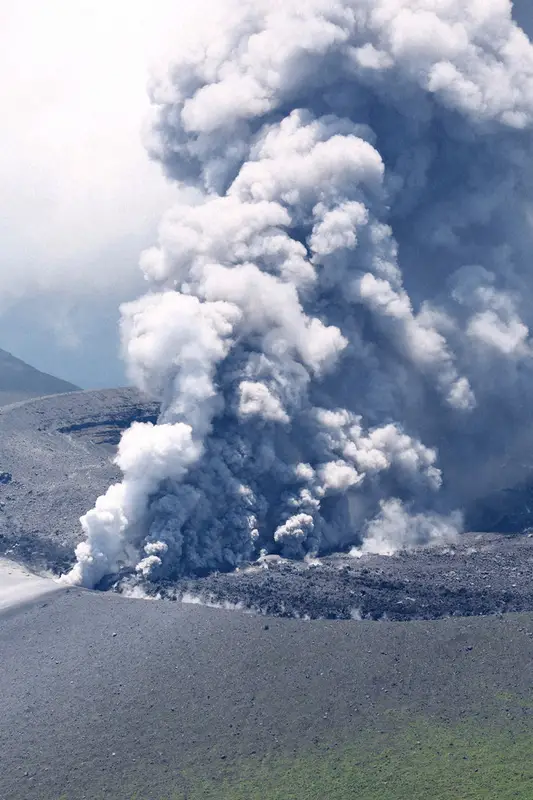
Episode 29 of the ongoing Halemaʻumaʻu eruption ended abruptly at 7:54 p.m. HST on June 29 after nearly 11 hours of continuous fountaining.
Waning north vent fountains stopped completely at 7:54 p.m. HST, several hours after reaching maximum heights up to 1,100 ft (340 m). Flames were visible at the south vent for a few minutes afterwards. High fountains produced approximately 1.6 billion gallons (6.2 million cubic meters) of lava covering 80% of the crater floor.
Since fountaining ended, volcanic gas emissions have greatly decreased. Lava flows from this episode on the floor of Halemaʻumaʻu within the southern part of Kaluapele (Kīlauea caldera) may continue to exhibit slow movement or incandescence as they cool and solidify over the coming days.
The Uēkahuna tiltmeter (UWD) recorded approximately 16.4 microradians of deflationary tilt during this episode. The end of the episode was coincident with a rapid change from deflation to inflation at the summit and a decrease in seismic tremor intensity.
Episode 27 of the Halema‘uma‘u Kīlauea summit eruption began around 9:05 a.m. HST on June 29, 2025. The north vent was active for majority of the eruption and reached approximately 1115 ft (~340 m) high by 11:00 am HST. The south vent became active with low level fountaining of about 65 ft (20 m) just before 4:00 p.m. HST. The fountains lasted just under 11 hours. Tephra (erupted volcanic material) was deposited over the crater rim wall shown in dark grey here.
Most episodes of Halemaʻumaʻu lava fountaining since the eruption started on December 23, 2024, have continued for around a day or less and have been separated by pauses in eruptive activity lasting generally at least several days.
No changes have been detected in the East Rift Zone or Southwest Rift Zone. HVO continues to closely monitor Kīlauea and will issue a VAN/VONA at the start of the next eruptive episode. If possible, HVO will also issue a VAN/VONA beforehand at the onset of low-level precursory activity. Daily updates will be published each morning as regularly scheduled.
Kīlauea Volcano Alert Level/Aviation Color Code remain at WATCH/ORANGE. All current and recent activity is within Hawaiʻi Volcanoes National Park.
Source : HVO .
Photos :USGS , USGS / H. Winslow.
Japan , Shinmoedake :
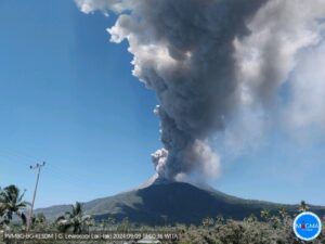
The alert continues around Mount Shinmoedake for a week after the first eruption in seven years
The Shinmoedake crater continues to emit volcanic smoke. Minoru Kanazawa from the headquarters helicopter at 11:49 a.m. on June 28, 2025, near the border between Miyazaki and Kagoshima Prefectures.
A week passed on the 29th since Mount Shinmoedake, in the Kirishima mountain range, straddling Miyazaki and Kagoshima Prefectures, erupted for the first time in seven years. According to the Fukuoka Regional Meteorological Observatory, several eruptions have occurred in recent days, and the eruption alert level 3 (restricting entry to the mountains) has been maintained. The meteorological observatory states that volcanic activity is ongoing and warns people to beware of heavy ashfall within a 3 km radius of the crater.
Source : Mainichi Shinbun .
Photo :Minoru Kanazawa.
Indonesia , Dukono :
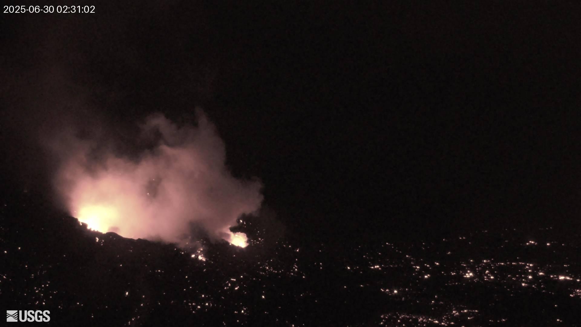
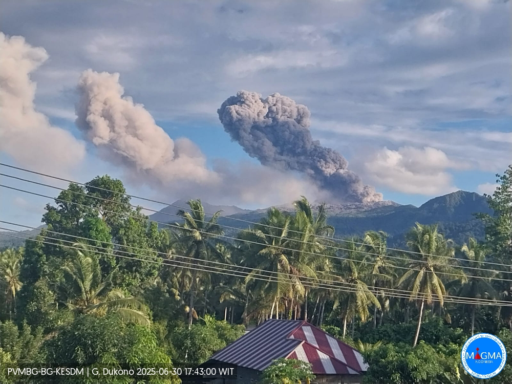
Mount Dukono erupted on Monday, June 30, 2025, at 01:04 UTC (10:04 local time). The observed ash column was ± 2,087 m (6,678 ft) above sea level or 1,000 m (3,200 ft) above the summit. The ash column was white to gray, with a strong intensity, oriented northeast. At the time of this report, the eruption was still ongoing.
VOLCANO OBSERVATORY NOTICE FOR AVIATION – VONA
Issued : June 30 , 2025
Volcano : Dukono (268010)
Current Aviation Colour Code : ORANGE
Previous Aviation Colour Code : orange
Source : Dukono Volcano Observatory
Notice Number : 2025DUK173
Volcano Location : N 01 deg 41 min 35 sec E 127 deg 53 min 38 sec
Area : North Maluku, Indonesia
Summit Elevation : 3478 FT (1087 M)
Volcanic Activity Summary :
Eruption with volcanic ash cloud at 0104 UTC (1004 local).
Volcanic Cloud Height :
Best estimate of ash-cloud top is around 6678 FT (2087 M) above sea level or 3200 FT (1000 M) above summit. May be higher than what can be observed clearly. Source of height data: ground observer.
Other Volcanic Cloud Information :
Ash cloud moving to east. Volcanic ash is observed to be white to gray. The intensity of volcanic ash is observed to be thick.
Remarks :
Eruption and ash emission is continuing. Eruption recorded on seismogram with maximum amplitude 34 mm. Tremor recorded on seismogram with maximum amplitude 4 mm.
Source et photo : Magma Indonésie .
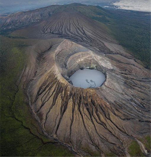
Costa Rica , Rincon de la Vieja :
Latitude: 10.83°N;
Longitude: 85.34°W;
Altitude: 1,916 m
Current Activity Level: Alert.
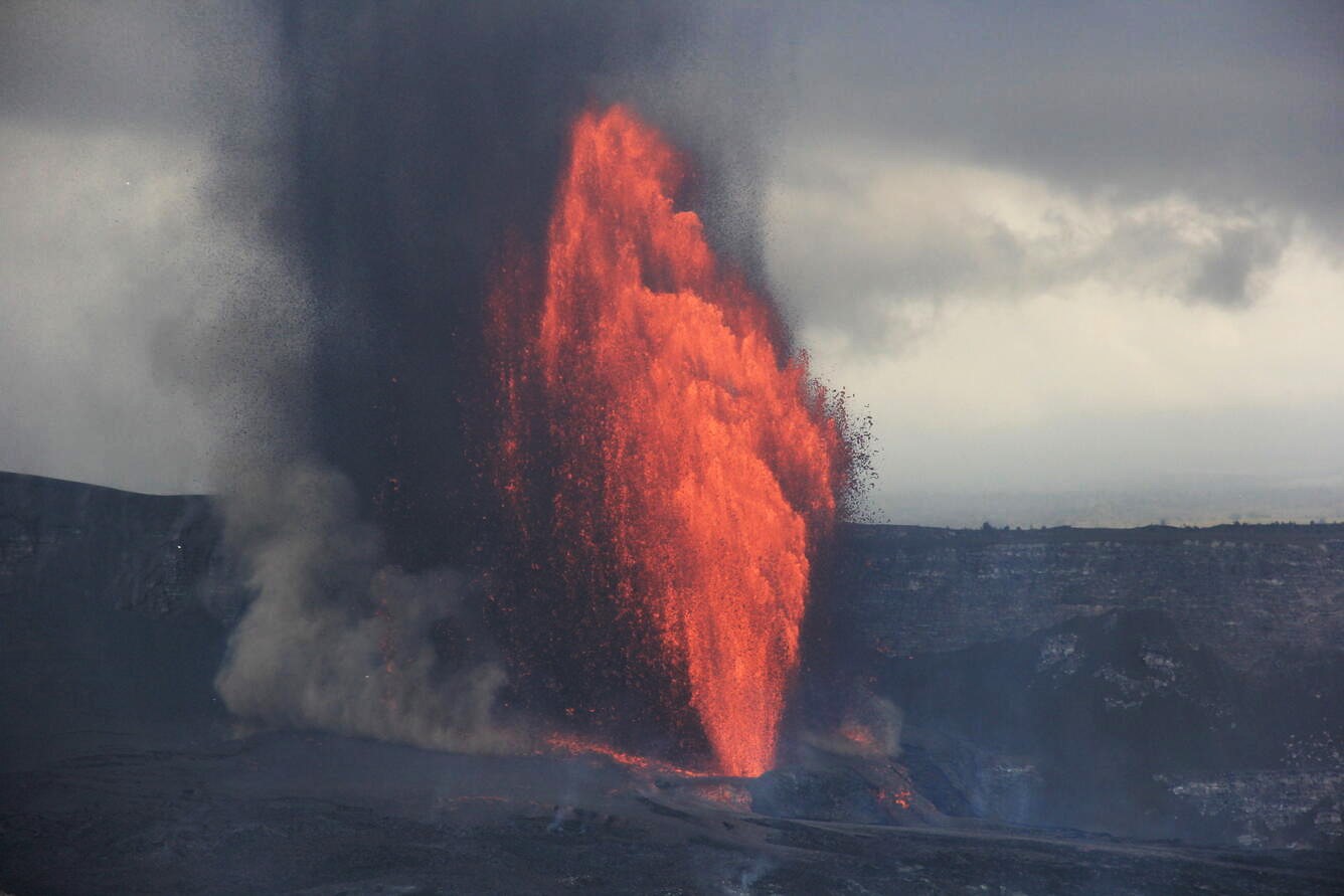
Two small eruptions and one exhalation were recorded this week. Neither generated lahars or ash emissions. Tornillo-type seismic events are still occurring, but their number has decreased compared to the previous week. The dominant frequency of tornillos in 2025 has generally decreased since January 2025, but a slight increase is observed this week.
The background tremor remained variable and showed a significant increase in amplitude from 22 June onwards. Occasionally, the tremor is pulsed with lower frequency content or harmonic components. Geodetic observations show no significant deformation, but a slight increasing trend at the base and top (to be confirmed in the coming weeks). This week, the SO2 flux (124 ± 96 t/d) increased slightly compared to the previous week (80 ± 56 t/d). The last detection of atmospheric SO2 by the TROPOMI sensor on the Sentinel-5P satellite was on 2 June.
Source : Ovsicori .
Photo : Soy Tico .
Italy , Campi Flegrei :
Weekly Bulletin, from June 16, 2025 to June 22, 2025. (Publication date: June 24, 2025)
ACTIVITY SUMMARY
In light of monitoring data, the following should be noted:
1) SEISMOLOGY: During the week of June 16 to 22, 2025, 58 earthquakes with a magnitude Md ≥ 0.0 (Mdmax = 3.2 ± 0.3) were located in the Phlegraean Fields region.
2) DEFORMATION: Since the beginning of April 2025, ground uplift has continued to be recorded, with a monthly average value of approximately 15 ± 5 mm/month. 3) GEOCHEMISTRY: No significant changes in the monitored geochemical parameters during the reporting week were reported, compared to the already known trends of increased flow rates and warming of the hydrothermal system. The temperature sensor installed in a fumarolic emission 5 meters from the main fumarole of Pisciarelli showed an average value of about 94 °C last week, a temperature close to the condensation of the fumarolic fluid.
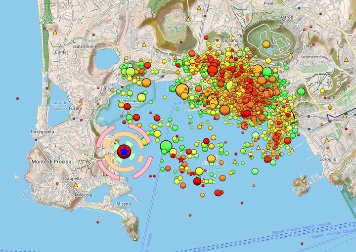
Magnitude 4.6 Earthquake in Baia, Gulf of Pozzuoli, East of Naples, Italy. – 06/30/2025 – 3:15 PM
A magnitude 4.6 earthquake occurred today at 12:47 PM local time in the Phlegraean Fields region. The epicenter was in the Gulf of Pozzuoli, near Castello di Baia, with a hypocenter at a depth of 4.9 km. Although larger than the magnitude 4.4 earthquake of a few months ago, which subsequently reached 4.6, due to its depth and distance from the city center, the recorded accelerations were less severe, and no significant damage was reported to buildings.
No major damage was detected in the Naples area. Civil Protection quickly activated surveillance in the waiting areas and surrounding areas, with no requests for assistance or critical situations reported.
The Municipal Operations Center (COC) is being set up and is ready to respond to any needs. As a precautionary measure, Civil Protection is ready to activate the waiting areas of Bagnoli and Agnano, as well as the reception area of Via Terracina, if the situation requires it.
Civil Protection continues to closely monitor the situation and encourages the population to comply exclusively with official information issued by the authorities.
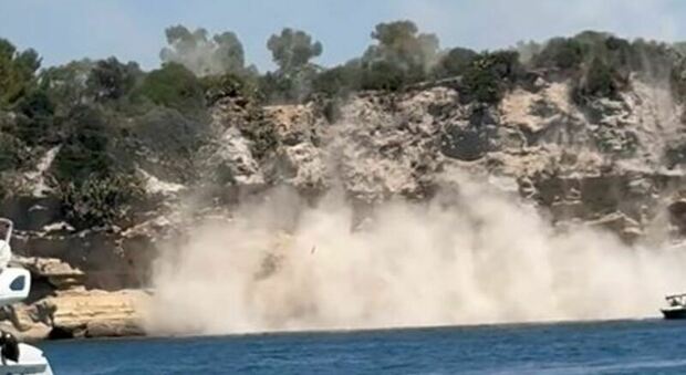
Regarding the damage, a cliff collapsed at Punta Pennata in Bacoli, and damage was also reported on the islet of Baia Castle. The Italo high-speed train and the region’s commuter trains were blocked for nearly three hours outside Naples. Checks are underway on the rail network due to the earthquake in the Phlegraean Fields.
THE PHLEGREAN FIELDS, A VERY SIGNIFICANT THREAT…
The problem in this area is that the evacuation of the Phlegraean Fields is aimed at preparing for a possible volcanic eruption in a densely populated area, which raises concerns for the safety of residents. Evacuating hundreds of thousands of people in the event of an eruption represents a complex logistical challenge. The main problem lies in the population density:
More than 500,000 people live in the « red zone » of the Phlegraean Fields, an area considered high-risk. This zone encompasses at least 18 communities, and an eruption could cause devastating pyroclastic flows. Evacuating such a large number of people, including the elderly, the sick, and children, requires careful planning and significant resources. The plan is to evacuate all these people in less than 72 hours.
In the yellow zone, nearly a million more people must be added, including the urban center of Naples. This is a daunting task, as it would take at least a week, if not longer. If the situation worsens, distributing 1.5 million people across Italy is no easy task.
Sources : INGV Vulcani , Volcanes y Ciencia Hoy – Volcanoes and Science Today .
Photos : INGV , Napoli fanpage .