June 28 , 2025.
Indonesia , Ili Lewotolok :
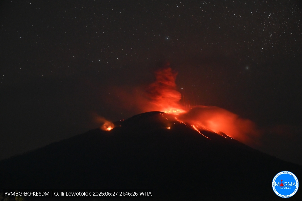
An eruption of Mount Ili Lewotolok occurred on Friday, June 27, 2025, at 9:46 PM WITA. The observed ash column was ± 500 m above the summit (± 1923 m above sea level). The ash column was gray and of moderate intensity, oriented towards the West. This eruption was recorded by seismograph with a maximum amplitude of 40 mm and a duration of 39 seconds.
Seismicity Observation:
96 eruption earthquakes with amplitudes of 16.6-40 mm and durations of 30-78 seconds.
114 emission earthquakes with amplitudes of 1.8-17.7 mm and durations of 29-59 seconds.
1 local tectonic earthquake with amplitudes of 25 mm and durations of 46 seconds.
2 distant tectonic earthquakes with amplitudes of 4.7-10.7 mm and durations of 63-97 seconds.
Recommendations
At Activity Level II (Alert), it is recommended:
(1) Communities living near Mount Ili Lewotolok, as well as visitors, climbers, and tourists, should not enter or carry out activities within a 2 km radius of the activity center of Mount Ili Lewotolok. Residents of the villages of Lamatokan and Jontona should remain vigilant regarding the potential risk of avalanches and landslides originating from the eastern portion of the peak/crater of Mount Ili Lewotolok.
(2) Communities living near Mount Ili Lewotolok, as well as visitors, mountaineers, and tourists, as well as residents of the villages of Jontona and Todanara, should not enter or carry out activities in the southern and southeastern sectors, up to 2.5 km from the center of activity of Mount Ili Lewotolok. They should remain vigilant regarding the potential risk of avalanches and landslides originating from the southern and southeastern portion of the peak/crater of Mount Ili Lewotolok.
Source et photo : Magma Indonésie .
Alaska , Spurr :
Unrest continues at Mount Spurr. The level of activity remains slightly above background, but is lower than observed in early 2025 . This decrease in activity suggests that the magma intrusion beneath Mount Spurr has stalled. The likelihood of an eruption has declined since March; however, fluctuations in unrest are not uncommon, and explosive activity remains possible. Should unrest escalate towards an eruption, we expect increases in seismic activity, gas emissions, surface deformation, and surface heating.
During the past week, 17 earthquakes within 3 miles (5 km) of Mount Spurr were located, all smaller than magnitude 1. The number of located earthquakes this week is slightly lower than the last two weeks, and lower than weekly counts from earlier in 2025. However, they are within the variability observed from week to week during this entire period of unrest. Ground deformation, as measured by GNSS (GPS) stations, remains paused as it has for the last two months.
Minor sulfur dioxide emissions were observed in satellite data one day this week. The last gas flight occurred June 11 and found that gas compositions and emission rates were broadly unchanged from those measured during the previous gas flight on May 23. On June 19, AVO installed a new continuous gas sensor on the rim of Crater Peak. Initial readings from the station show high carbon dioxide emissions from the vent, and no sulfur dioxide, consistent with past gas flights. The new station will allow for continuous measurements of Crater Peak gas emissions when wind conditions allow, includes seismic and infrasound instrumentation, and is a significant improvement to our monitoring capabilities.
No significant surface changes were observed at Mount Spurr over the past week. Earlier this week, AVO installed a new livestream camera at station SPCL: Mount Spurr Live Stream (SPCL). A livestream of Mount Spurr, as viewed from Glen Alps in Anchorage, is also available .
AVO continues to closely monitor activity at Mount Spurr for signals indicating the volcano is moving closer to an eruption using local seismic, infrasound, and GNSS (GPS) stations, web cameras, airborne and satellite gas measurements, regional infrasound, lightning networks, and satellite images.
Source : AVO
Photo : Loewen, Matt/ AVO/USGS.
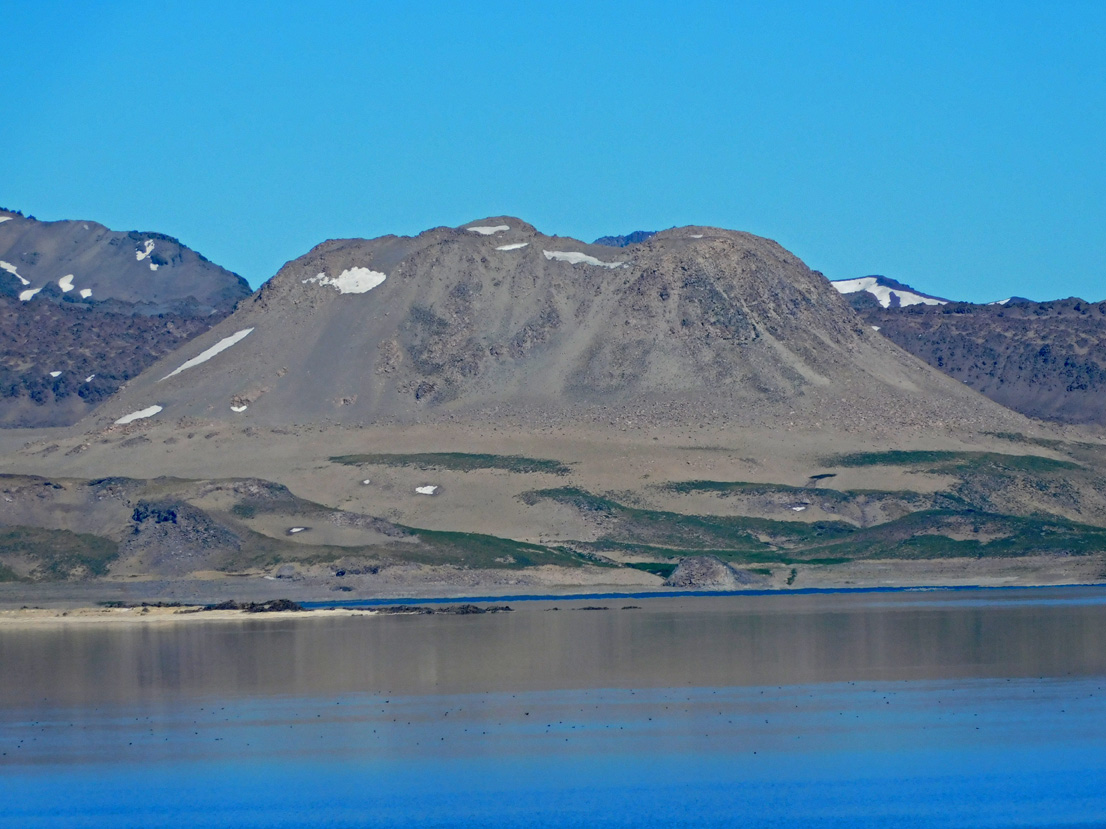
Chile , Laguna del Maule :
Special Report on Volcanic Activity (REAV), Maule Regions, Laguna del Maule Volcanic Complex, June 27, 2025, 10:05 a.m. local time (Continental Chile)
The National Geology and Mining Service of Chile (Sernageomin) announces the following preliminary information, obtained using the monitoring equipment of the National Volcanic Monitoring Network (RNVV), processed and analyzed at the Southern Andean Volcano Observatory (OVDAS):
On Friday, June 27, 2025, at 9:50 a.m. (1:50 p.m. UTC), monitoring stations installed near the Laguna del Maule volcanic complex recorded an increase in the occurrence of volcano-tectonic earthquakes (associated with rock fracturing within the volcanic system), reaching a total of 103 earthquakes in the last few hours, characterizing this episode. seismic like a swarm of earthquakes.
The characteristics of the highest-energy earthquake after its analysis are as follows:
TIME OF ORIGIN: 09:38 local time (13:38 UTC)
LATITUDE: 36.063° S
LONGITUDE: 70.498° W
DEPTH: 5.9 km
LOCAL MAGNITUDE: 2.0 (ML)
Observation:
At the time of this report, seismic events with similar characteristics but lower energy are still being recorded.
The Volcanic Technical Alert remains at GREEN.
Source : Sernageomin
Photo : Álvaro Vivanco – Volcán Domos del Maule.
Colombia , Nevado del Ruiz :
Manizales, June 24, 2025, 4:45 p.m.
Regarding the monitoring of the activity of the Nevado del Ruiz volcano, the Colombian Geological Survey (SGC), an entity attached to the Ministry of Mines and Energy, reports that:
From June 17 to 23, 2025, the volcano continued to exhibit unstable behavior. Compared to the previous week, the main variations in the monitored parameters were:
– Seismicity related to fluid dynamics in the volcanic conduits decreased, both in terms of the number of recorded events and the seismic energy released. The energy levels of the seismic signals were low. During the week, no ash emissions were confirmed, nor were any temperature changes associated with these signals observed. This is partly due to the heavy cloud cover, which limits the visibility of these phenomena through the cameras (conventional or thermographic) used to monitor the volcano. Seismic activity associated with rock fracturing processes within the volcanic edifice decreased in the number of recorded events and increased in the released seismic energy. The seismic events were located in the Arenas crater, mainly within a radius of less than 5 km around the crater, on the east, northeast, and southeast flanks of the volcano. The depth of the earthquakes ranged from less than 1 km to 8 km from the volcanic summit. The highest magnitude of the week was 1.1, corresponding to the earthquake recorded on June 21 at 7:22 a.m., located in the Arenas crater, at a depth of 2 km.

– The emission of water vapor and gases, mainly sulfur dioxide (SO2), into the atmosphere from the Arenas Crater was variable. Daily SO2 fluxes decreased slightly compared to the previous week. Satellite monitoring, currently being evaluated, continues to show SO2 emissions.
– The vertical height of the gas, ash, and water vapor column remained below 900 m, measured above the volcano’s summit. It should be noted that its estimation was affected by the high cloud cover in the region during the week. The column’s dispersion direction showed a predominant trend toward the northwest and west-northwest flanks of the volcano.
– When monitoring thermal anomalies at the floor of the Arenas Crater using satellite monitoring platforms, detection was limited by the high cloud cover in the region; however, some reports of low energy levels were obtained.
Source et photo : SGC.
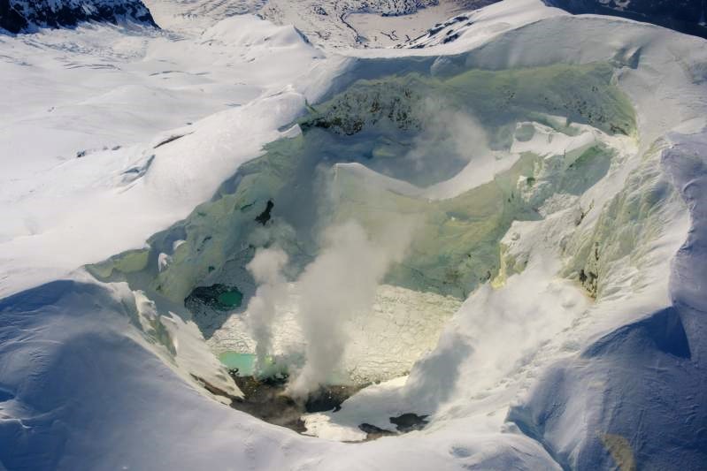
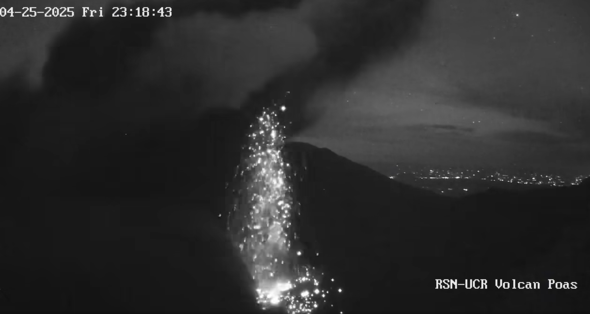
Costa Rica , Poas :
OVSICORI-UNA Weekly Volcano Monitoring Bulletin, June 27, 2025
Latitude: 10.20°N;
Longitude: 84.23°W;
Altitude: 2,687 m (8,687 ft)
Current Activity Level: Caution
Following the eruption on May 19, no further explosive events have been recorded. However, weak ash emissions were observed last week.
This week, the amplitude of the continuous seismic tremor remains low and stable compared to recent months. Acoustic tremor remains generally stable, with some temporary increases associated with weak ash emissions. The number of long-period events has increased compared to last week. This week, a single volcano-tectonic event was recorded in the Poás edifice. In recent weeks, uplift and expansion of the crater have ceased, and no significant deformation is currently observed on the geodetic network. The average SO2 flux over the past week was 352 ± 48 t/d. The mass of SO2 measured in the atmosphere of Costa Rica by the TROPOMI sensor on the Sentinel-5P satellite remained high, with values frequently exceeding 500 tonnes and reaching 900 tonnes on 26 June.
The MultiGAS station near Boca A measured an average SO2/CO2 ratio of 1.5 ± 0.7 this week, similar to last week, compared to values of 3 to 4 in May. The H2S/SO2 ratio has remained very low (< 0.1) in recent weeks. The gases are interpreted as originating from a surface magmatic source, but the magmatic input has decreased. The level of the new Boca C lake continues to rise, particularly between June 24 and 26, in connection with the heavy rains of June 25 (123 mm according to the IMN). Boca A remains dry, with incandescent light at night, except for the night of June 25 to 26, probably due to the strong evaporation of the water that entered in the afternoon.
Source : Ovsicori .
Photo : RSN-UCR. Capture d’écran .