June 27 , 2025.
Indonesia , Ibu :
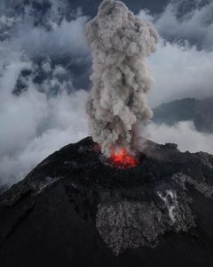
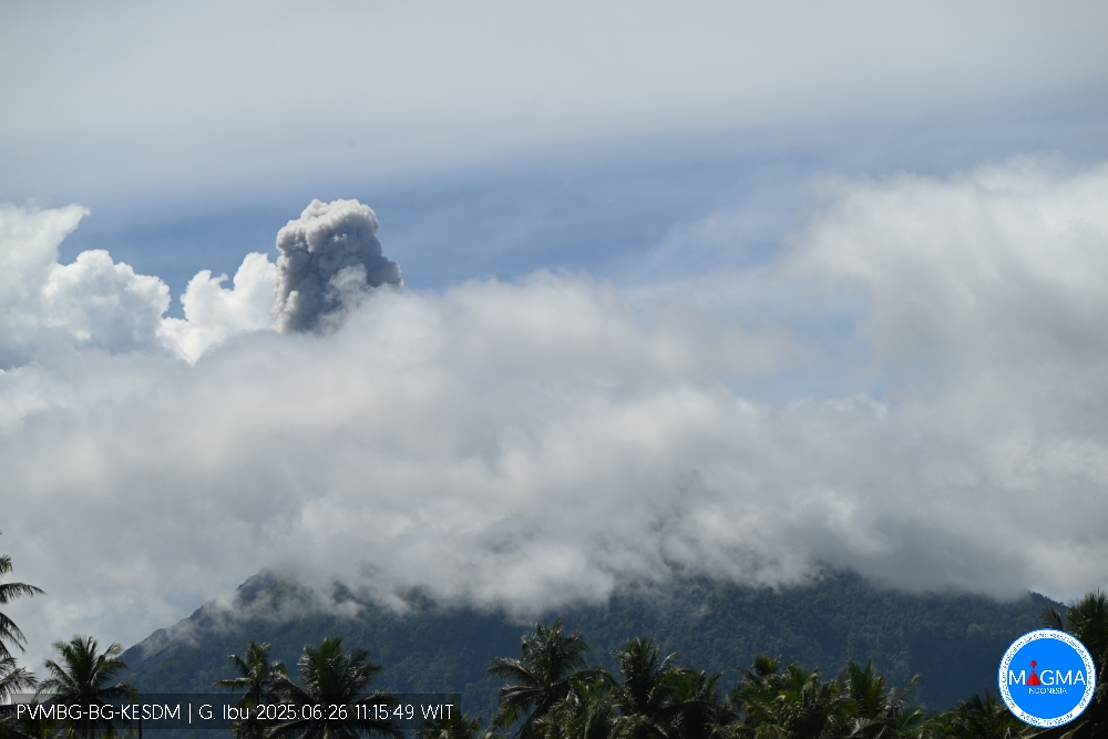
Mount Ibu erupted on Thursday, June 26, 2025, at 11:15 WIT. The observed ash column was ± 600 m above the summit (± 1925 m above sea level). The ash column was gray and of strong intensity, oriented northwest. This eruption was recorded by seismograph with a maximum amplitude of 12 mm and a duration of 59 seconds.
VOLCANO OBSERVATORY NOTICE FOR AVIATION – VONA
Issued : June 26 , 2025
Volcano : Ibu (268030)
Current Aviation Colour Code : ORANGE
Previous Aviation Colour Code : orange
Source : Ibu Volcano Observatory
Notice Number : 2025IBU872
Volcano Location : N 01 deg 29 min 17 sec E 127 deg 37 min 48 sec
Area : North Maluku, Indonesia
Summit Elevation : 4240 FT (1325 M)
Volcanic Activity Summary :
Eruption with volcanic ash cloud at 02h15 UTC (11h15 local).
Volcanic Cloud Height :
Best estimate of ash-cloud top is around 6160 FT (1925 M) above sea level or 1920 FT (600 M) above summit. May be higher than what can be observed clearly. Source of height data: ground observer.
Other Volcanic Cloud Information :
Ash cloud moving to northwest. Volcanic ash is observed to be gray. The intensity of volcanic ash is observed to be thick.
Remarks :
Eruption recorded on seismogram with maximum amplitude 12 mm and maximum duration 59 second.
Source et photo : Magma Indonésie .
Colombia , Puracé – Los Coconucos volcanic chain:
Popayán, June 24, 2025, 3:00 p.m.
Regarding the monitoring of the activity of the Puracé Volcano – Los Coconucos Volcanic Chain, the Colombian Geological Survey (SGC), an entity affiliated with the Ministry of Mines and Energy, reports that:
During the week of June 17-23, 2025, seismic activity showed a decrease in the number of earthquakes compared to the previous week. However, the energy released increased, related to the occurrence of a volcano-tectonic earthquake measuring 3.6 magnitude on June 20, 2025, at 2:58 p.m., 14 km northeast of the Puracé Volcano. It was felt in the municipalities of Totoró, Inzá, Puracé, Popayán, Cali, and Pitalito. Earthquakes associated with rock fracturing were located mainly between the Puracé and Piocollo volcanoes, at depths between 1 and 3 km, with magnitudes less than 1.0. The remaining seismic activity was scattered northwest and southwest of the Puracé volcano, at distances between 15 and 18 km from the crater. Earthquakes associated with fluid movements were located beneath the crater of the Puracé volcano, at a depth of less than 1 km, and were characterized by their low energy input.
Moderate sulfur dioxide (SO2) emissions were recorded by satellite detection and field instruments. Furthermore, the slow deformation process continued between the Puracé, Piocollo, and Curiquinga volcanic edifices. In images captured by visible and infrared webcams, degassing processes and thermal anomalies continued to be observed inside the crater of the Puracé volcano and in the fumarole field on the outer rim of the crater, respectively. On June 20, two events associated with minor secondary mudflows were recorded, caused by the action of precipitation on ash deposited on the slopes of the volcanic chain.
In conclusion, continuous degassing from the Puracé volcano crater continued throughout the week, accompanied by moderate SO₂ emissions, localized seismic activity beneath the structures of the Puracé and Piocollo volcanoes, and slow ground deformation, indicating the persistence of an active volcanic system.
Based on the above, the SGC recommends closely monitoring the evolution of volcanic activity through weekly and special bulletins, in addition to information published through official channels, and following the instructions of local and departmental authorities and the National Disaster Risk Management Unit (UNGRD).
Source et photo : SGC
Iceland , Reykjanes Peninsula :
Sundhnúkagígar crater row: “Maybe running out of fuel”
Land inflation beneath Svartsengi continues to fluctuate daily, and volcanologist Þorvaldur Þórðarson says these irregularities may signal that volcanic activity is starting to slow down.
“If the machine is starting to sputter a bit—well, we all know what it means when we’re running out of gas. It starts stalling and showing signs that it’s about to slow down and stop. Maybe the Sundhnúkur system is simply running low on fuel,” he said.
Inflation continues beneath Svartsengi
According to Þórðarson, the data suggests the Reykjanes Peninsula may be taking an early summer break—but, he adds, it’s just as likely to come back early from vacation.
Eruption likely if activity resumes
Þórðarson explains that magma is flowing into the shallow chamber at a rate of about 2 cubic meters per second. If that continues, along with steady land inflation, a new volcanic event could occur between mid-July and mid-August.
“If something does happen, it will likely be an eruption near the same area as before—just south of Stóra-Skógfell. The fissure could then extend either north or south—or both,” he said.
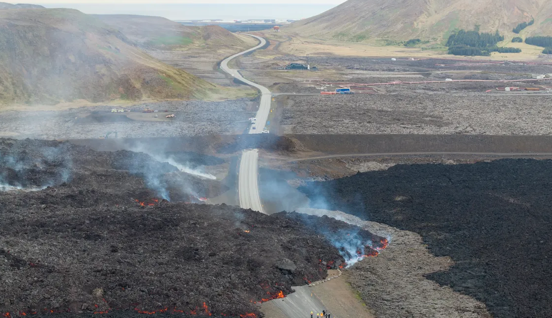
Inflation at Svartsengi continues, eruption risk rises toward autumn
He expects the next eruption to be similar to the last one, though the duration will depend on how much magma is released.
“The volume accumulating between events has been increasing slightly over time. In March it was around 20 million cubic meters—now it’s nearing 25 million. If we assume 25 million cubic meters, we’re probably looking at the end of July or early August,” he noted, adding that the data remains uncertain.
“There isn’t much disagreement among scientists—the resolution of the data just isn’t very high.”
Possible impact on the Reykjavík area
Þórðarson also points to signs of activity in other areas, including Móhalsadalur and Krýsuvík. “One suspects that magma is starting to accumulate under that region—it’s a known volcanic zone. The fissure system between Sveifluháls and Trölladyngja runs north from there. If that becomes active, we could see an eruption far enough north to directly affect the greater Reykjavík area.”
He adds that Reykjanes itself has also been sending signals through frequent earthquake swarms, likely indicating magma buildup.
“If that system activates, we could see a submarine eruption, which could disrupt air traffic to and from Keflavík International Airport,” Þórðarson said.
Source : Icelandmonitor mbl.is .
Photo : RÚV – Ragnar Visage ( archive 2024)
Japan , Kuchinoerabujima :
The Japan Meteorological Agency (JMA) reported that the number of shallow volcanic earthquakes increased beneath an area near Kuchinoerabujima’s Furudake Crater in April and continued to increase. Sulfur dioxide emissions were low, averaging 20-80 tons per day since April, and there were days in April where the emissions were below detectable limits. Deformation data indicated ongoing inflation. Volcanic earthquakes with somewhat large amplitudes were occasionally recorded in May by the seismic network. There were many (135) volcanic earthquakes recorded during 2-11 June. No changes to geothermal areas located in and around both Shindake and Furudake craters were observed during a field survey conducted on 11 June. The Alert Level was raised to 3 (on a scale of 1-5) at 2100 on 11 June; the public was warned that ejected blocks may land within 2 km of both craters, and pyroclastic flows may affect areas between Shindake Crater and the coast.
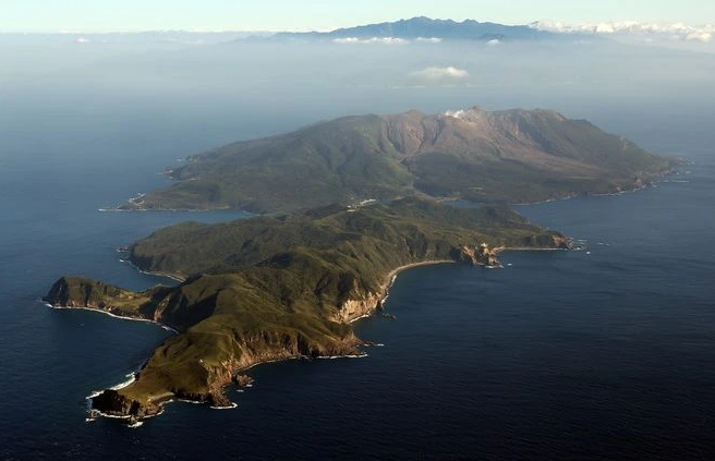
A group of young stratovolcanoes forms the eastern end of the irregularly shaped island of Kuchinoerabujima in the northern Ryukyu Islands, 15 km W of Yakushima. The Furudake, Shindake, and Noikeyama cones were erupted from south to north, respectively, forming a composite cone with multiple craters. All historical eruptions have occurred from Shindake, although a lava flow from the S flank of Furudake that reached the coast has a very fresh morphology. Frequent explosive eruptions have taken place from Shindake since 1840; the largest of these was in December 1933. Several villages on the 4 x 12 km island are located within a few kilometers of the active crater and have suffered damage from eruptions.
Source: Japan Meteorological Agency (JMA), GVP .
Photo : Asahi Shimbun
Mexico , Popocatepetl :
June 26, 11:00 a.m. (June 26, 5:00 p.m. GMT)
Activity in the past 24 hours
55 low-intensity exhalations accompanied by water vapor and other volcanic gases were detected. In addition, 603 minutes of low-amplitude tremor segments were recorded, including 421 minutes corresponding to high-frequency tremor and 182 minutes to harmonic tremor.
During the morning and thus far, visibility toward the volcano has been intermittent due to adverse weather conditions. However, if exhalations of water vapor, volcanic gases, and/or ash are recorded, the emissions are expected to follow a predominantly northwest (NW) trajectory.
The Popocatépetl Volcano Warning Light is at Yellow Phase 2.
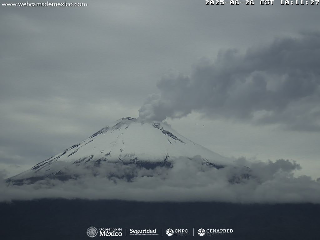
The expected scenarios for this phase are as follows:
A few minor to moderate explosions
Occurrence of tremors of varying amplitude
Light to moderate ashfall in surrounding towns and some more distant towns
Expulsion of incandescent fragments within a 12-kilometer exclusion radius
Lahars descending into ravines are expected due to ash accumulation on the slopes and their interaction with the precipitation expected in the coming weeks
Possibility of pyroclastic flows not reaching towns.
Source et photo : Cenapred .