June 24 , 2025 .
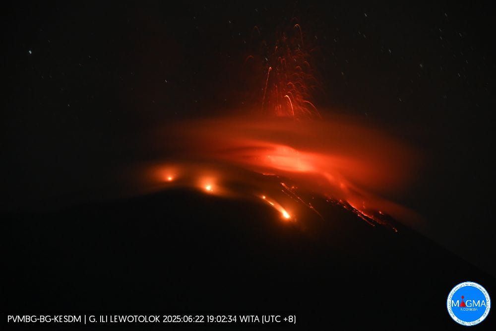
Indonesia , Ili Lewotolok :
An eruption of Mount Ili Lewotolok occurred on Monday, June 23, 2025, at 6:56 PM WITA. The observed ash column was ± 400 m above the summit (± 1823 m above sea level). The ash column was gray and thick, oriented toward the West. This eruption was recorded by seismograph with a maximum amplitude of 40 mm and a duration of 44 seconds.
VOLCANO OBSERVATORY NOTICE FOR AVIATION – VONA
Issued : June 23 , 2025
Volcano : Ili Lewotolok (264230)
Current Aviation Colour Code : ORANGE
Previous Aviation Colour Code : orange
Source : Ili Lewotolok Volcano Observatory
Notice Number : 2025LEW034
Volcano Location : S 08 deg 16 min 19 sec E 123 deg 30 min 18 sec
Area : East Nusa Tenggara, Indonesia
Summit Elevation : 4554 FT (1423 M)
Volcanic Activity Summary :
Eruption with volcanic ash cloud at 23h24 UTC (07h24 local).
Volcanic Cloud Height :
Best estimate of ash-cloud top is around 7434 FT (2323 M) above sea level or 2880 FT (900 M) above summit. May be higher than what can be observed clearly. Source of height data: ground observer.
Other Volcanic Cloud Information :
Ash cloud moving from west to northwest. Volcanic ash is observed to be gray. The intensity of volcanic ash is observed to be thick.
Remarks :
Eruption recorded on seismogram with maximum amplitude 34.7 mm and maximum duration 73 second.
Source et photo : Magma Indonésie .
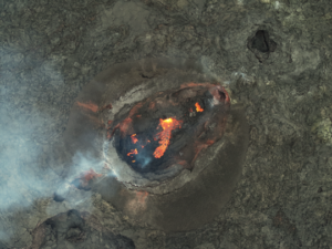
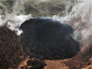
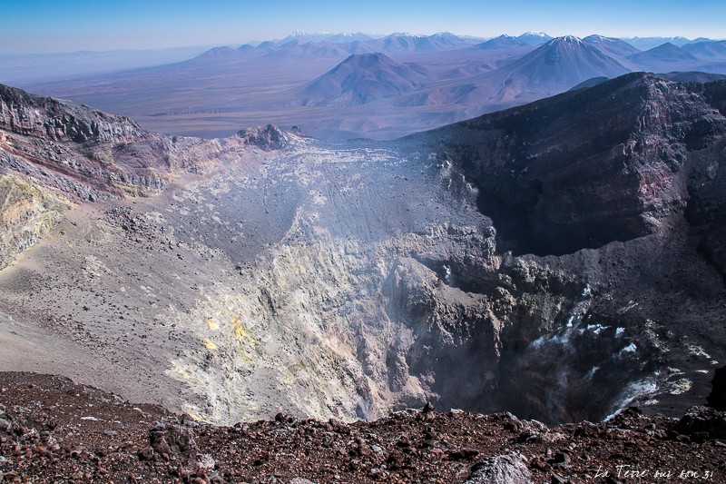
Chile , Lascar :
Seismology
Seismological activity during the period was characterized by:
6 VT-type seismic events, associated with rock fracturing (volcano-tectonics).
9 LP-type seismic events, associated with fluid dynamics within the volcanic system (long period). The magnitude of the largest earthquake, estimated using the reduced displacement (DR) parameter, was 4 cm².
Fluid Geochemistry
Sulfur dioxide (SO₂) emission data obtained by differential optical absorption spectroscopy (DOAS), corresponding to the Emu station, located 6 km east-southeast of the active crater, showed an average SO₂ flux of 1,254 t/d for the period evaluated, with a maximum daily value of 2,572 t/d on June 12. These values are thought to be due to a seasonal effect, with strong winds affecting measurements of this gas.
No atmospheric sulfur dioxide (SO2) emission anomalies were reported in the area near the volcanic complex, according to data published by the Tropospheric Monitoring Instrument (TROPOMI) and the Sulfur Dioxide Group of the Ozone Monitoring Instrument (OMI).
Satellite Thermal Anomalies
During this period, 25 thermal alerts were recorded in the area associated with the volcano, using the MIROVA platform. The maximum value was 3.3 MW for the MODIS sensor on June 3. Sentinel 2-L2A satellite images from June 1, 6, and 11, combined with the bands, show the continuity of the radiance pattern characterized by three zones within the active crater. Similarly, the total radiance surface calculated by the NHI platform (Normalized Hotspot Indices, Marchese et al., 2019) for the active crater indicates 6,300 m² for June 8, a value considered moderate.
Geodesy
The geodetic activity for the period was characterized by:
– Low vertical deformation rates (rates not exceeding 0.3 cm/month), with very slight variations characteristic of the method that do not suggest internal changes in the volcanic system.
Low deformation rates along the line (distance between stations) crossing the volcano (not exceeding 0.2 cm/month) and exhibiting stable behavior.
– No deformation was observed according to radar interferometry (images updated to June 8, 2025), which is consistent with the data recorded by the GNSS equipment network.
Therefore, no deformation was observed in the volcanic system for the period evaluated.
Surveillance Cameras
Images provided by surveillance cameras installed around the volcano, when weather conditions permitted, recorded white degassing columns, mainly oriented east-southeast, with a maximum height of 420 m above the crater on June 7. Incandescence was identified on June 6, 9, 10, and 15, and was observed intermittently during the nights of the period assessed.
Satellite Geomorphological Analysis
According to satellite images from Planet Scope and Sentinel 2 L2A, no morphological changes have been identified in the volcanic system.
In recent weeks, a gradual decline in instrumental data has been observed, with a decrease in the occurrence and magnitude of seismic activity related to volcanic processes.
Furthermore, daily sulfur dioxide (SO₂) fluxes remain below the threshold considered abnormal for this volcano, and there is no evidence of volcanic deformation. All of the above suggests a stabilization of volcanic dynamics, indicating a low probability of migration to more intense activity states that would stimulate surface activity. However, thermal and radiative anomalies are still being recorded in the active crater. It should be noted that the Láscar volcano has historically recorded minor explosions accompanied by few instrumental signals; such phenomena may therefore still occur. In light of the above, it is determined that the system has gradually returned to instrumental parameters considered within its baseline threshold, which has changed its technical alert to:
GREEN TECHNICAL ALERT: Active volcano with stable behavior – No immediate risk
Source : Sernageomin
Photo : La terre sur son 31 .
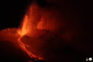
Hawaii , Kilauea :
Monday, June 23, 2025, 9:21 AM HST (Monday, June 23, 2025, 19:21 UTC)
19°25’16 » N 155°17’13 » W,
Summit Elevation 4091 ft (1247 m)
Current Volcano Alert Level: WATCH
Current Aviation Color Code: ORANGE
Activity Summary:
The ongoing Halema’uma’u eruption is paused. Another episode is likely, but more time and data are needed before a time window can be forecast. Summit inflation continues, along with persistent and slightly elevated seismic tremor. Vigorous degassing continues from both vents. Magma remains close to the surface in both the north and south conduits and strong glow is visible from both vents at night.
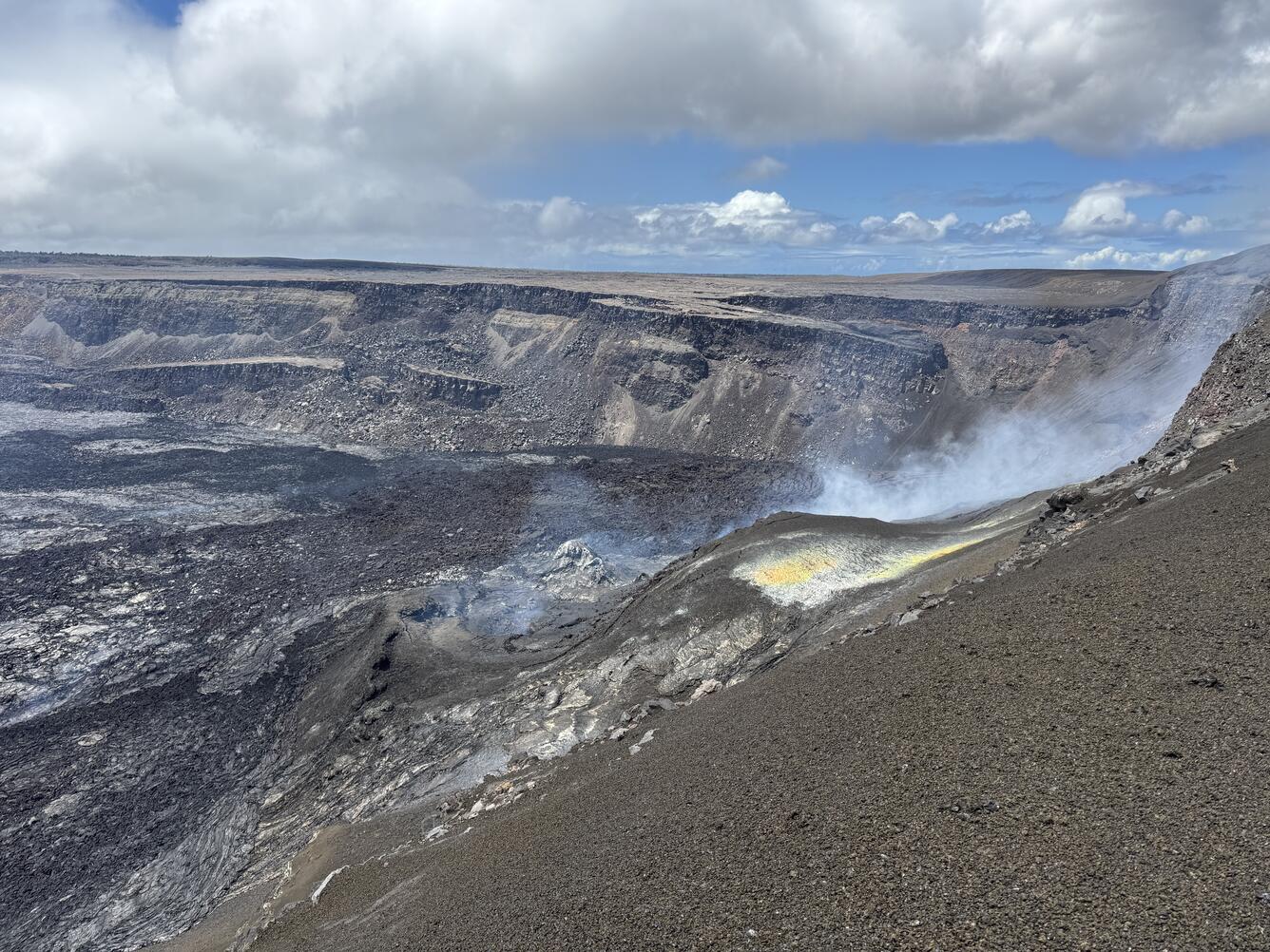
Summit Observations:
Overnight, incandescence at both the north and south vents in Halemaʻumaʻu crater was visible in Kīlauea summit webcams. Lava flows from episode 26 on the floor of Halemaʻumaʻu within the southern part of Kaluapele (Kīlauea caldera) continue to exhibit minor incandescence as they cool and solidify. Episode 26 began at approximately 1:40 a.m. on June 20 and ended at 10:25 a.m. on June 20. Lava fountains from the north vent reached heights of up to about 1,250 feet (380 meters) during episode 26, a new fountain height record for this eruption.
The tiltmeter near Uēkahuna (UWD) has recorded over 8 microradians of inflationary tilt since the end of episode 26. UWD recorded more than 18 microradians of deflationary tilt during episode 26. Seismic tremor continues at slightly elevated levels beneath Halemaʻumaʻu crater.
Vigorous degassing also continues from both the north and south vents. The average Sulfur dioxide (SO2) emission rate during inter-episode pauses, such as the current pause, is typically around 1,200 t/d.
Source : HVO
Photo : USGS / M. Patrick.
La Martinique , Mount Pelée :
Weekly Report, Paris Institute of Earth Physics / Martinique Volcanological and Seismological Observatory
Saint-Pierre, June 20, 2025 at 3:15 p.m. local time (GMT-4)
This week, volcanic activity was characterized by 20 observed earthquakes of volcanic origin.
Between June 13, 2025 at 4:00 p.m. (UT) and June 20, 2025 at 4:00 p.m. (UT), the OVSM recorded:
• 18 low-energy volcano-tectonic earthquakes. These earthquakes were clearly identified as originating from one of the well-known seismically active zones on Mount Pelée,
located between 1.0 and 1.4 km deep below the volcano’s summit. The shallow volcano-tectonic seismicity is associated with microfracturing in the volcanic edifice, linked to the overall reactivation of the volcano observed since late 2018.
• One long-period earthquake located at a depth of 20 km, approximately 9 km northeast of Mount Pelée, with a magnitude of Mlv = 1.0. Deep long-period earthquakes contain only low frequencies and are associated with the circulation of magmatic fluids deep within the Mount Pelée volcanic system.
• One deep hybrid earthquake located at a depth of 29 km, approximately 6 km northeast of Mount Pelée, with a magnitude of Mlv = 1.5. Hybrid seismic signals are enriched in low frequencies and are also generally associated with the circulation of magmatic fluids deep within the Mount Pelée volcanic system.
No earthquakes were felt by the population.
The previous week, the OVSM recorded 43 earthquakes of volcanic origin. As of June 20, 2025, and over the past four weeks, the OVSM has observed a total of 147 volcanic earthquakes, an average of 36 to 37 earthquakes per week.
During phases of volcanic reactivation in volcanoes similar to Mount Pelée, it is common to observe seismic activity of varying intensity and frequency.
For more details on observations and interpretations of volcanic activity over the longer term, refer to the OVSM’s monthly bulletins.
The alert level is currently YELLOW: vigilance.
Source : Direction de l’OVSM-IPGP.
Photo : OVSM
Japan , Shinmoedake :
TOKYO : Shinmoedake, a volcano in the mountain range on the border of Japan’s Kagoshima and Miyazaki prefectures, erupted on Sunday, marking its first eruption since 2018.
The Japan Meteorological Agency (JMA) reported that the eruption occurred at around 4:37 pm local time, sending a plume of ash over 500 metres above the crater.
The smoke drifted eastward toward Miyazaki prefecture, and no falling volcanic rocks have been confirmed so far, the national broadcaster NHK reported.
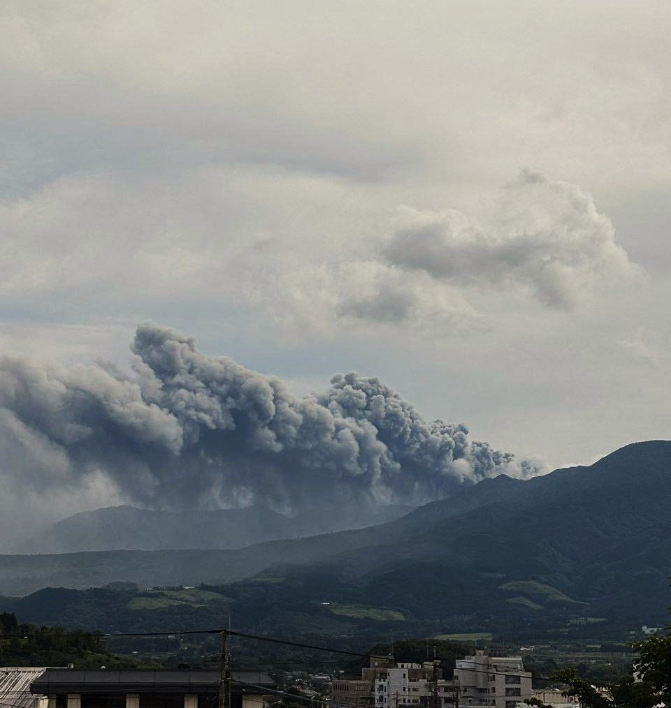
Volcanic alert level two, which restricts entry near the crater, remains in effect for the region.
Authorities urge caution within a 2-km radius of the crater due to the risk of large volcanic rocks and pyroclastic flows within approximately one kilometre.
Residents are advised to stay alert, especially on the downwind side, where ash and small rocks may be carried over long distances.
Source : The Star / Bernama-Xinhua
Photo : via Alex Terry / FB.