June 21 , 2025.
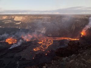
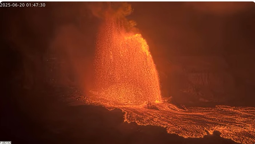
Hawaii , Kilauea :
HVO/USGS Volcanic Activity Notice
Current Volcano Alert Level: WATCH
Current Aviation Color Code: ORANGE
Issued: Thursday, June 19, 2025, 11:54 PM HST
Source: Hawaiian Volcano Observatory
Notice Number: 2025/H290
Location: N 19 deg 25 min W 155 deg 17 min
Elevation: 4091 ft (1247 m)
Area: Hawaii
Volcanic Activity Summary:
Low-level precursory activity started within Halemaʻumaʻu at 11:26 p.m. HST on 6/19/2025 when lava began overflowing from the north vent. Episode 26 is likely to begin within the next 24 hours. According to the National Weather Service, winds are forecasted to blow from the north-northeast direction within the next 48 hours.
In recent episodes of the ongoing eruption within Halemaʻumaʻu, precursory low-level activity has lasted from a few hours to a few days. This activity can include spatter from north and/or south vents, small dome fountains, and lava overflowing from one or both vents. At the start of previous episodes, precursory activity has rapidly escalated into sustained high fountaining over minutes to tens of minutes.
The tiltmeter at Uēkahuna (UWD) has recorded 15 microradians of inflationary tilt since the end of the last episode. Low level seismic tremor continues beneath Halemaʻumaʻu crater.
Issued: Friday, June 20, 2025, 2:10 AM HST
Volcanic Activity Summary:
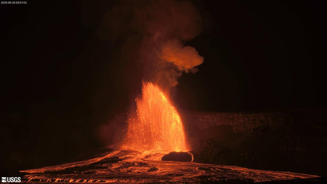
Episode 26 of the ongoing Halemaʻumaʻu eruption began at approximately 1:40 a.m. HST on June 20, 2025, with lava fountains and flows erupting from the north vent. Lava fountains are currently reaching heights of over 1,000 feet (300 meters).
According to the National Weather Service, winds are blowing from the north direction, which suggests that volcanic gas emissions and tephra from the lava fountain may be distributed south of Halema’uma’u caldera.
Episode 26 was preceded by small, sporadic spattering and lava overflows from the north vent that began at approximately 11:26 p.m. and continued to increase in intensity until 1:40 a.m., when sustained fountaining began. Fountains from north vent are 800 feet (250 meters) high and feeding a lava flow at 1:55 a.m. HST.
Inflationary tilt reached just over 15.3 microradians since the end of the last episode. Seismic tremor began increasing and tilt at UWD switched from inflationary to deflationary at about 1:40 a.m. HST, about the same time lava fountaining increased in intensity.
Most episodes of Halemaʻumaʻu lava fountaining since December 23, 2024, have continued for around a day or less and have been separated by pauses in eruptive activity lasting generally at least several days.
No changes have been detected in the East Rift Zone or Southwest Rift Zone. A VAN/VONA will be issued when sustained lava fountaining ceases and the eruption is paused, or earlier if the situation warrants a further update.
Issued: Friday, June 20, 2025, 10:58 AM HST
Volcanic Activity Summary:
Episode 26 of the ongoing Halemaʻumaʻu eruption ended abruptly at 10:25 a.m. HST on Friday, June 20, when lava fountains and flows stopped erupting from the south vent. The episode consisted of about 8 hours of continuous lava fountaining.
The north vent stopped erupting at approximately 10:07 a.m. HST. The south vent stopped erupting at approximately 10:25 a.m. HST, marking the end of the episode. Lava fountains reached heights of well over 1,000 ft (300 m) during this episode. Volcanic gas emissions have greatly decreased. Lava flows from this episode on the floor of Halemaʻumaʻu within the southern part of Kaluapele (Kīlauea caldera) will continue to exhibit slow movement and incandescence as they cool and solidify over the coming days.
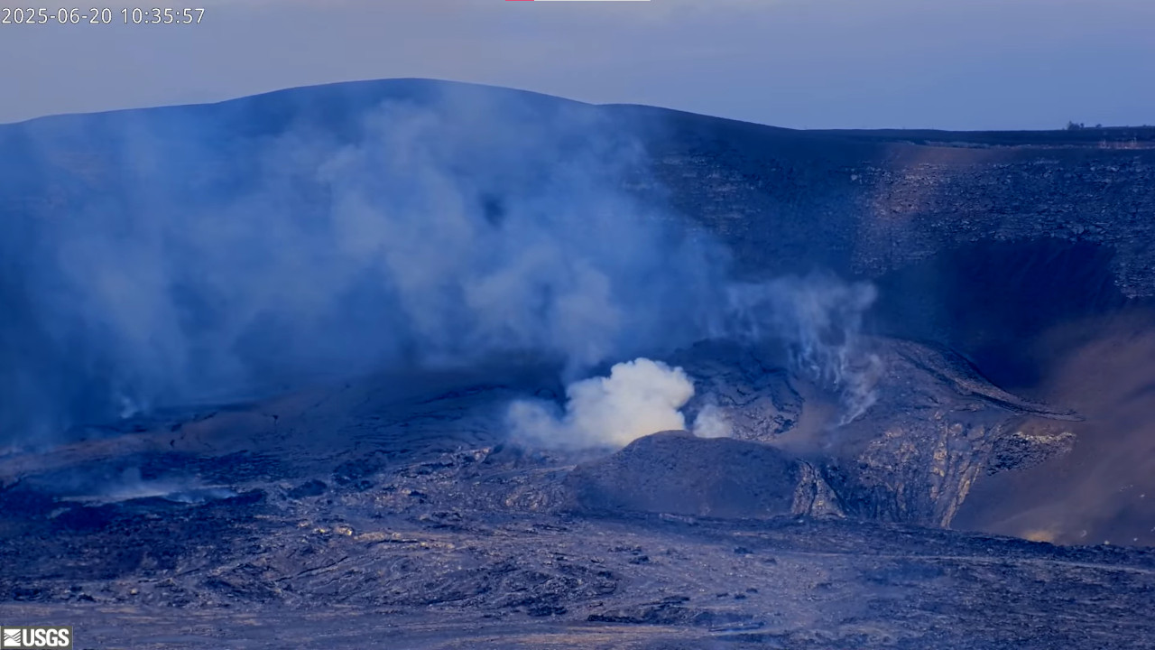
The Uēkahuna tiltmeter (UWD) recorded more than 18 microradians of deflationary tilt during this episode. The end of the eruption was coincident with a rapid change from deflation to inflation at the summit and a decrease in seismic tremor intensity.
Most episodes of Halemaʻumaʻu lava fountaining since the eruption started on December 23, 2024, have continued for around a day or less and have been separated by pauses in eruptive activity lasting generally at least several days.
Source : HVO
Photos : USGS
Indonesia , Lewotobi Laki-laki :
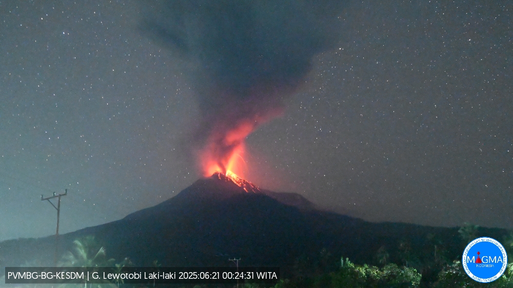
An eruption of Mount Lewotobi Laki-laki occurred on Saturday, June 21, 2025, at 14:31 UTC (22:31 local time). The observed ash column was ± 2,000 m above the summit (± 3,584 m above sea level). The ash column was gray and of strong intensity, oriented towards the south and southwest. At the time of this report, the eruption was still ongoing.
VOLCANO OBSERVATORY NOTICE FOR AVIATION – VONA
Issued : June 21 , 2025
Volcano : Lewotobi Laki-laki (264180)
Current Aviation Colour Code : ORANGE
Previous Aviation Colour Code : orange
Source : Lewotobi Laki-laki Volcano Observatory
Notice Number : 2025LWK343
Volcano Location : S 08 deg 32 min 20 sec E 122 deg 46 min 06 sec
Area : East Nusa Tenggara, Indonesia
Summit Elevation : 5069 FT (1584 M)
Volcanic Activity Summary :
Eruption with volcanic ash cloud at 1431 UTC (2231 local).
Volcanic Cloud Height :
Best estimate of ash-cloud top is around 11469 FT (3584 M) above sea level or 6400 FT (2000 M) above summit. May be higher than what can be observed clearly. Source of height data: ground observer.
Other Volcanic Cloud Information :
Ash cloud moving from south to southwest. Volcanic ash is observed to be gray. The intensity of volcanic ash is observed to be thick.
Remarks :
Eruption and ash emission is continuing. Eruption recorded on seismogram with maximum amplitude 47.3 mm.
Source et photo : Magma Indonésie .
Alaska , Spurr :
Unrest continues at Mount Spurr. The level of activity is still above background, but lower than observed in early 2025. This decrease in activity suggests that the magma intrusion beneath Mount Spurr has stalled. The likelihood of an eruption has declined since March, but fluctuations in unrest are not uncommon, and explosive eruptions are still possible. Should unrest escalate towards an eruption, we expect increases in seismic activity, gas emissions, surface deformation, and surface heating.
During the past week, 42 earthquakes were located, all smaller than magnitude 1. The number of located earthquakes this week is about the same as the last two weeks, and lower than weekly counts from earlier in 2025. However, they are within the variability observed from week to week during this entire period of unrest. Ground deformation, as measured by GNSS (GPS) stations, remains paused as it has for the last two months.
Minor sulfur dioxide emissions were observed in satellite data one day this week. The last gas flight occurred June 11 and found that gas compositions and emission rates were broadly unchanged from those measured during the previous gas flight on May 23. Yesterday, June 19, AVO installed a new continuous gas sensor on the rim of Crater Peak. Initial readings from the station show high carbon dioxide emissions from the vent, and no sulfur dioxide, consistent with past gas flights. The new station will allow for continuous measurements of Crater Peak gas emissions when wind conditions allow, includes seismic and infrasound instrumentation, and is a significant improvement to our monitoring capabilities.
No significant surface changes were observed at Mount Spurr over the past week.
Source : AVO
Photo : Loewen, Matt / Alaska Volcano Observatory / U.S. Geological Survey
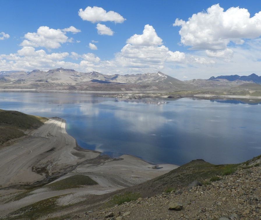
Chile , Laguna del Maule :
Special Report on Volcanic Activity (REAV), Maule Regions, Laguna del Maule Volcanic Complex, June 20, 2025, 1:20 p.m. local time (Continental Chile)
The National Geology and Mining Service of Chile (SERNAGEOMIN) announces the following preliminary information, obtained using the monitoring equipment of the National Volcanic Monitoring Network (RNVV), processed and analyzed at the Southern Andean Volcano Observatory (OVDAS):
On Friday, June 20, 2025, at 10:00 a.m. (2:00 p.m. UTC), monitoring stations installed near the Laguna del Maule volcanic complex recorded an increase in the occurrence of volcano-tectonic earthquakes (associated with rock fracturing within the volcanic system), reaching a total of 105 earthquakes in the last few hours, characterizing this episode. seismic as a swarm of volcano-tectonic type earthquakes.
The earthquake characteristics after analysis are as follows:
TIME OF ORIGIN: 12:15 local time (16:15 UTC)
LATITUDE: 36.0598°S
LONGITUDE: 70.4768°W
DEPTH: 7.5 km
LOCAL MAGNITUDE: 1.8 (ML)
Observation:
At the time of this report, lower-energy seismic events continue to be recorded.
The Volcanic Technical Alert remains at GREEN.
Source : Sernageomin
Photo : Auteur inconnu
Colombia , Galeras :
San Juan de Pasto, June 17, 2025, 3:50 p.m.
Regarding the monitoring of the activity of the Galeras Volcano, the Colombian Geological Survey (SGC), an entity affiliated with the Ministry of Mines and Energy, reports that:
During the week of June 10-16, 2025, the main variations in the monitored parameters compared to the previous week were:
● A significant increase in seismic occurrence and energy release was observed. The predominance of seismic activity related to rock fracture processes within the volcanic edifice continued.

● Fracture earthquakes were mainly located in two seismic sources.
● The first, near the volcanic crater, at a depth of less than 3 km from the summit of the Galeras volcano (4,200 m above sea level). The second was located approximately 8 km northeast of the volcanic edifice, at depths between 8 and 12 km. Particularly noteworthy were the seismic events recorded on June 10 and 11, with magnitudes of 3.1 and 2.8, and felt by some residents of the municipality of Pasto.
● Low gas emissions were observed, mainly from the fumarole fields of El Paisita, to the north, and Las Chavas, to the west of the active cone, with low white columns and variable dispersion depending on the wind direction.
● Other volcanic monitoring parameters showed stability.
In light of the above, the SGC recommends closely monitoring developments through weekly bulletins and other information published through our official channels, as well as instructions from local and departmental authorities and the National Disaster Risk Management Unit (UNGRD).
Volcanic activity remains on yellow alert: active volcano with changes in the reference level of monitored parameters and other manifestations.
Source et photo : SGC