June 13 , 2025.
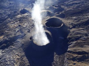
Hawaii , Kilauea :
Thursday, June 12, 2025, 9:01 AM HST (Thursday, June 12, 2025, 19:01 UTC)
19°25’16 » N 155°17’13 » W,
Summit Elevation 4091 ft (1247 m)
Current Volcano Alert Level: WATCH
Current Aviation Color Code: ORANGE
Activity Summary:
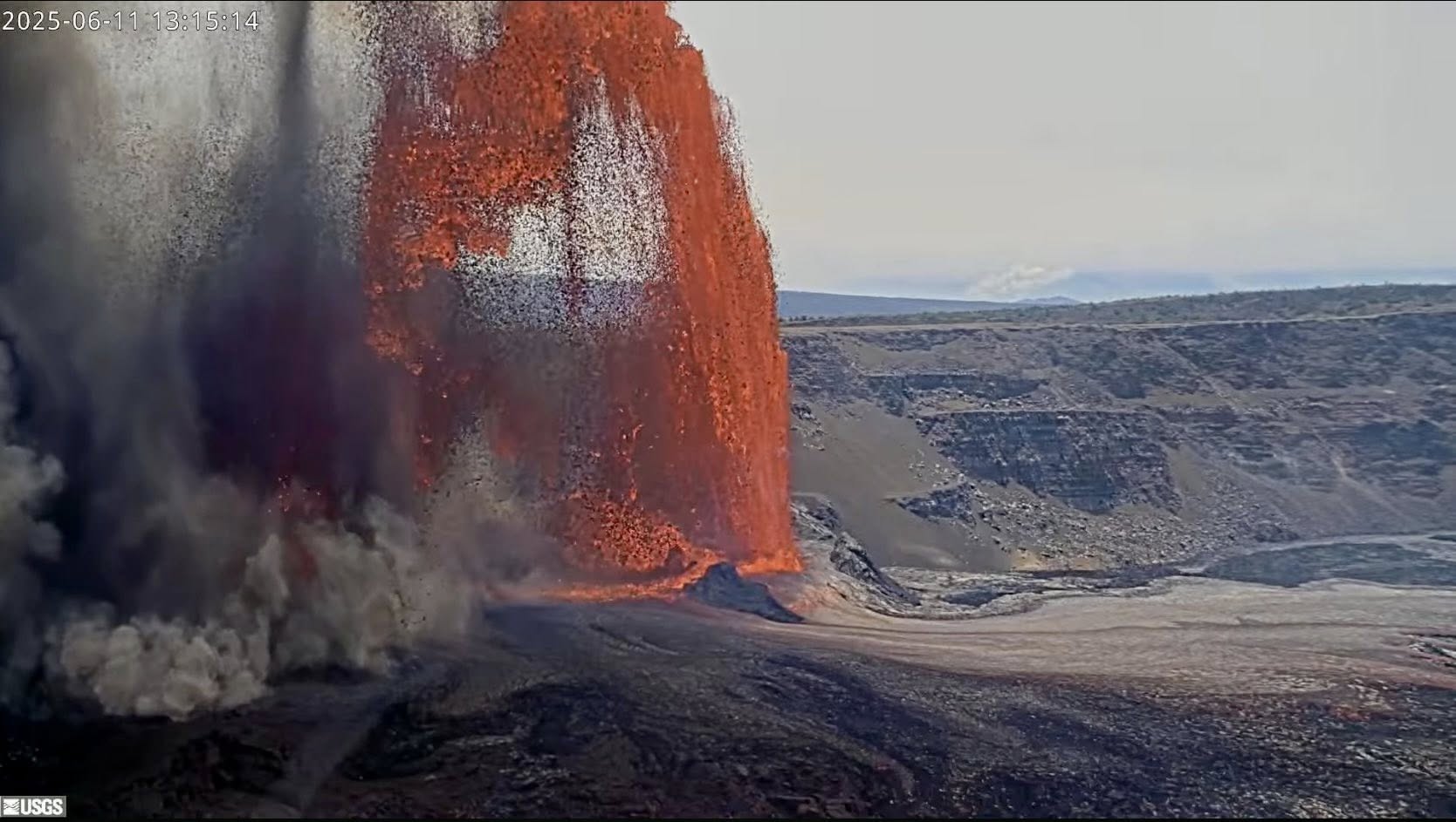
Episode 25 of the ongoing Halema’uma’u eruption ended last night, June 11, at 8:08 p.m. after about 8 hours of sustained fountaining. The end of the episode was coincident with a change from deflationary to inflationary tilt at the summit and a decrease in seismic tremor intensity. This morning, summit inflation continues, along with persistent, low level seismic tremor, suggesting another episode is possible. However, more time and data is needed before a forecast window can be made.
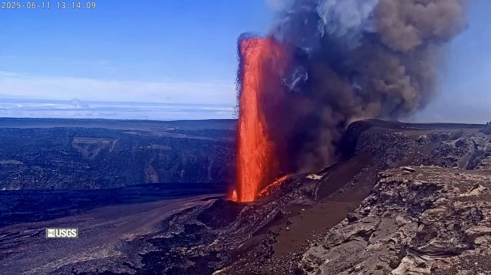
Fountaining episodes have occurred approximately once per week since the start of the eruption on December 23, 2024. All eruptive activity remains within Hawaiʻi Volcanoes National Park. No significant activity has been noted along Kīlauea’s East Rift Zone or Southwest Rift Zone. Current hazards include ongoing volcanic gas emissions and windblown volcanic glass (Pele’s hair) and tephra deposited during past episodes in the Kīlauea summit region of Hawaiʻi Volcanoes National Park and nearby communities.
Summit Observations:
Episode 25 was preceded by intermittent gas-pistoning in the north vent, with associated small spatter fountains and lava flows which began before dawn on June 10. This activity, which occurred at a rate of about 5-10 gas piston events per hour, continued to increase in intensity until 11:57 a.m. on June 11, when a small, sustained dome fountain in the north vent began to feed lava flows onto the crater floor. North vent lava fountain heights increased markedly around 12:30 p.m. and by 12:45 p.m. were reaching heights of more than 500 feet (more than 150 meters). The vigor of activity continued to increase and at approximately 1 p.m., lava fountains from the north vent reached heights of more than 1,000 feet (305 meters). At 1:30 p.m., a small fountain, less than 50 meters (165 feet) high, started to erupt from the south vent. Lava fountains continued to erupt from both vents, feeding large lava flows that covered parts of Halema’uma’u crater floor. Eruption vigor at both vents began to decrease around 3:45 p.m., as fountain heights lowered gradually over the following hours. The north vent stopped erupting at approximately 7:36 p.m. HST on June 11. The south vent stopped erupting at approximately 8:08 ap.m. HST, marking the end of the episode .
Lava flows from this episode on the floor of Halemaʻumaʻu within the southern part of Kaluapele (Kīlauea caldera) may continue to exhibit slow movement or incandescence as the cool and solidify over the coming days.
The eruptive plume from episode 25 reached at least 20,000 feet (6,000 meters) above ground level by 1:30 p.m. HST on June 11. Sulfur dioxide (SO2) emissions were estimated at more than 50,000-75,000 tonnes per day (t/d) during episode 25. The average sulfur dioxide (SO2) emission rate during inter-episode pauses, such as the ongoing pause, is typically around 1,200 tonnes per day (t/d).
Episode 25 was accompanied by about 14 microradians of deflationary tilt at a tiltmeter near Uēkahuna (UWD), a couple of microradians more deflation than the amount seen during episode 24. The end of the episode was coincident with a change from deflationary tilt to inflationary tilt at the summit and a decrease in seismic tremor intensity.
Summit tiltmeters have continued to record inflationary tilt following the end of episode 25. UWD has recovered about 1.5 microradians of inflationary tilt in the 13 hours since the end of episode 54. Seismic tremor has returned to slightly elevated levels beneath Halemaʻumaʻu crater.
Source et photos : HVO.
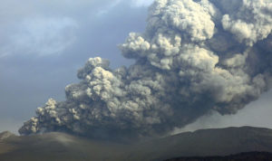
Indonesia , Raung :
SPECIAL REPORT ON THE ACTIVITY OF RAUNG VOLCANO, EAST JAVA, ON JUNE 12, 2025
Raung Volcano, one of the active volcanoes in East Java, has been on Alert Level II (Waspada) since December 19, 2023. From June 5 to 11, 2025, continuous eruptions were observed, producing a white to gray column of moderate intensity, reaching a maximum height of 400 to 750 m above the summit. On June 12, 2025, the eruptive column turned gray with an increase in pressure, and a height variation reaching approximately 1,000 m above the summit, moving south-southeast.
Seismic activity at Mount Raung is dominated by explosion/eruption earthquakes, with no fewer than 16 events occurring between 7 and 11 June 2025. Observations of fluctuating seismic energy, tending to increase on 12 June 2025, but not gradually, are thought to be related to the release of fluids (gas, liquids, rocky solids) due to eruptions from relatively shallow sources. This is corroborated by the fact that no volcanic earthquakes were recorded during the same period.
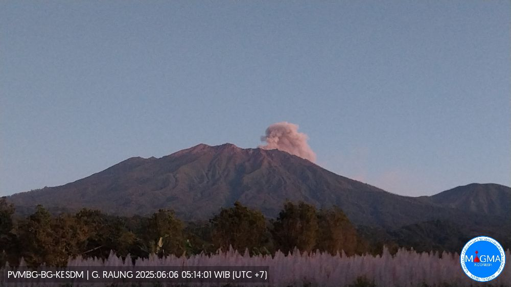
From June 5 to 12, 2025, the eruptive materials from Mount Raung were primarily ash-sized rocks, and their distribution was limited to the crater rim, so they did not alter the hazard threat. The activity level is still considered relevant, at Level II (Waspada), with a recommendation not to undertake activities within a 3 km radius of the crater/summit.
Regarding the volcanic activity of Mount Raung, the public is urged to comply with the recommendations issued by the Geological Agency, through the Center for Volcanology and Geological Disaster Mitigation, not to be influenced by false and irresponsible information regarding the activity of Mount Raung, and to follow the instructions of the competent agency, namely the Geological Agency, which will continue to collaborate with the BNPB, the BMKG, ministries/institutions, regional governments, and other relevant agencies.
Information on Mount Raung activity and coordination by the regional government, provincial and regency BPBD can also be obtained/implemented through the Mount Raung Observation Post in Mangaran Village, Sumber Arum Village, Songgon District, Banyuwangi Regency, East Java, or the Volcanology and Geological Disaster Mitigation Center in Bandung.
Source et photo : PVMBG.
Colombia , Puracé – Los Coconucos volcanic chain:
Popayán, June 10, 2025, 3:00 p.m.
Regarding the monitoring of seismic activity at the Puracé volcano and the Los Coconucos volcanic chain, the Colombian Geological Survey (SGC), an entity affiliated with the Ministry of Mines and Energy, reports that:
During the week of June 3 to 9, 2025, seismic activity did not experience significant variations. The number of events continued to show a slight downward trend, and the energy released by these events remained low.
Earthquakes associated with rock fracturing were located mainly between the Puracé and Piocollo volcanoes, at depths between 1 and 3 kilometers (km), reaching a maximum magnitude of 1.5. The remaining seismic activity was concentrated to the west and north of Puracé Volcano, at distances between 1 and 3 km from the crater. Fluid-driven earthquakes were located beneath the crater of Puracé Volcano, at a depth of less than 1 km, and are characterized by their low energy input.
Satellite and field detection instruments recorded moderate levels of sulfur dioxide (SO₂) emissions. Furthermore, the slow deformation process continued between the Puracé, Piocollo, and Curiquinga volcanic edifices.
In images captured by visible and infrared webcams, degassing processes continued to be observed in the lateral fumarole and within the crater of Puracé Volcano.
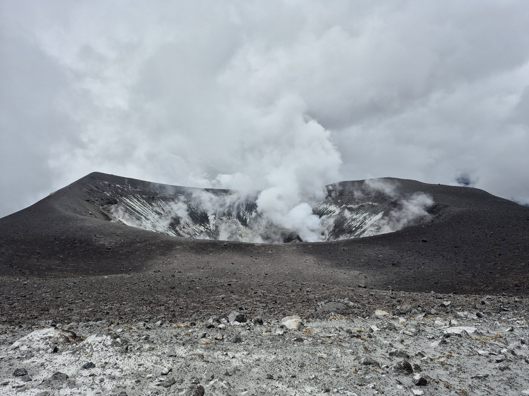
In conclusion, continuous degassing from the lateral fumarole and crater of the Puracé volcano continued throughout the week, accompanied by moderate SO₂ emissions, localized seismic activity beneath the structures of the Puracé and Piocollo volcanoes, and slow ground deformation, indicating the persistence of an active volcanic system.
Regarding certain messages on social media reporting ashfall in the city of Popayán, it is clarified that no ash emissions have been reported into the atmosphere in recent days. In light of the above, the SGC recommends closely monitoring the evolution of volcanic activity through weekly and special bulletins, in addition to information published through official channels, and following the instructions of local and departmental authorities and the National Disaster Risk Management Unit (UNGRD).
At yellow alert status, phenomena such as sporadic ash emissions (minor eruptions of limited magnitude and effects, whose dispersion depends on wind direction), the presence of incandescence, small explosions in the crater, low-energy thermal anomalies, noise, felt earthquakes, odors, precipitation of elemental sulfur near the crater and in hot springs and fumaroles, as well as degassing in areas other than the crater, may also occur. Fissure formation and the occurrence of minor lahars, among other things, may also occur.
The volcanic activity alert remains yellow: active volcano with changes in the basic behavior of monitored parameters and other manifestations.
Source et photo : SGC.
Costa Rica , Poas :
ERUPTION REPORT – OVSICORI-UNA
Location: N10.20 W84.23
Mass elevation: 2,687 m (8,813 ft)
Date: 12/06/2025
Time: 2:50 PM
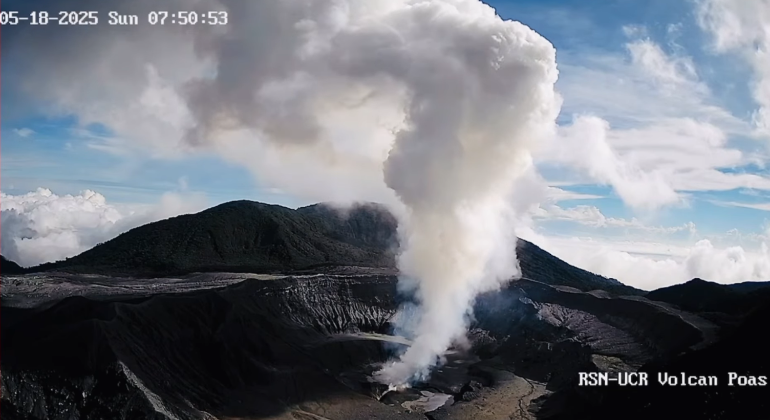
Plume height (above crater): 700 m (2,296 ft)
Plume observation source:
Webcams, low-amplitude acoustic tremor.
Observed Activity:
Eruptive pulse with moderate ash emission today, June 12, 2025, from 2:50 PM until the publication of this report. The eruptive plume is rich in water vapor and gas, and has a moderate ash load.
The plume is white and gray, with a moderate ash load. The wind is dispersing it horizontally toward the southwest at 17 km/h (IMN).
Poás Volcano has been in a continuous eruption phase since March 23, 2025, with more intense pulses accompanied by ash emissions. Eruptive activity was maximal and was marked by frequent ash emissions between March and April. Between May and June, eruptive activity remained passive, with sporadic pulses and increased emissions of steam, gas, and ash.
Activity Level: CAUTION.
Source : Ovsicori .
Photo : RSN/UCR ( 18/05/2025)
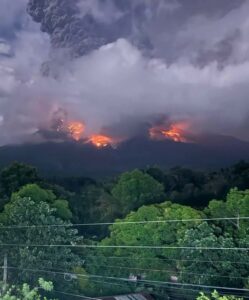
Guatemala , Fuego :
Weather: Partly cloudy.
Wind: Southeast.
Precipitation: 80.0 mm.
Activity:
The Fuego Volcano Observatory reports volcanic activity consisting of 2 to 4 weak to moderate explosions per hour. These explosions eject columns of grayish gas and ash between 4,300 and 4,800 meters above sea level. These explosions move northwestward, causing ashfall in the areas surrounding the volcano.
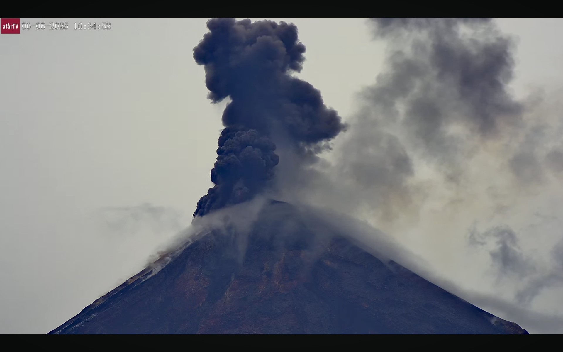
This activity is associated with low to moderate rumbling, locomotive-like degassing noises, and weak shock waves. Remaining blocks from the June 7 eruption have been observed descending by gravity in the form of weak avalanches. These deposits can be carried away as lahars or currents by precipitation; it is therefore recommended not to remain in or near the volcano’s ravines. Therefore, follow the recommendations in special bulletin BEFGO-013-2025.
Source : Insivumeh .
Photo : Afar tv ( 6/6/2025)