May 12 , 2025 .
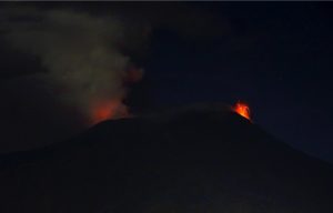
Hawaii , Kilauea :
HAWAIIAN VOLCANO OBSERVATORY STATUS REPORT / U.S. Geological Survey
Sunday, May 11, 2025, 1:28 PM HST (Sunday, May 11, 2025, 23:28 UTC)
19°25’16 » N 155°17’13 » W,
Summit Elevation 4091 ft (1247 m)
Current Volcano Alert Level: WATCH
Current Aviation Color Code: ORANGE
Activity Summary:
Episode 21 sustained lava fountaining from the north vent began at 12:45 p.m. HST on May 11, 2025. Dome fountains at the start of new gas-piston cycle evolved into to continuous lava fountains that grew rapidly in vigor and height. North vent lava fountains are 500 feet high (150 m) and are feeding lava flows covering about 10-20% of the floor of Halema’uma’u crater. The south vent is not currently active.
The onset of sustained fountaining was accompanied by a rapid change in summit tilt from inflation to deflation along with a rapid increase in tremor. The Uēkahuna tiltmeter (UWD) recorded approximately 7 microradians of inflationary tilt between the end of episode 20 and the beginning of episode 21 persistent fountaining.
Episode 21 sustained fountaining was preceded by 4 hours and 45 minutes of precursory low-level activity marked by gas-pistoning events in the north vent cycling from dome fountaining and ponding of lava to vigorous drainbacks.
Each episode of Halemaʻumaʻu lava fountaining since December 23, 2024, has continued for 13 hours to 8 days and episodes have been separated by pauses in eruptive activity lasting less than 24 hours to 12 days.
Strong degassing (50,000 tonnes of SO2 per day estimated) accompanied by tephra and Pele’s hair accompany the fountaining. Winds are from the northeast blowing the plume southwest away from the main viewing areas and communities.
No changes have been detected in the East Rift Zone or Southwest Rift Zone. HVO continues to closely monitor Kīlauea and will issue an eruption update tomorrow morning unless there are significant changes before then.
Kīlauea Volcano Alert Level/Aviation Color Code remain at WATCH/ORANGE. All current and recent activity is within Hawaiʻi Volcanoes National Park.
Source : HVO
Photo : Capture d’écran vidéo Epic Lava / FB
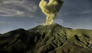
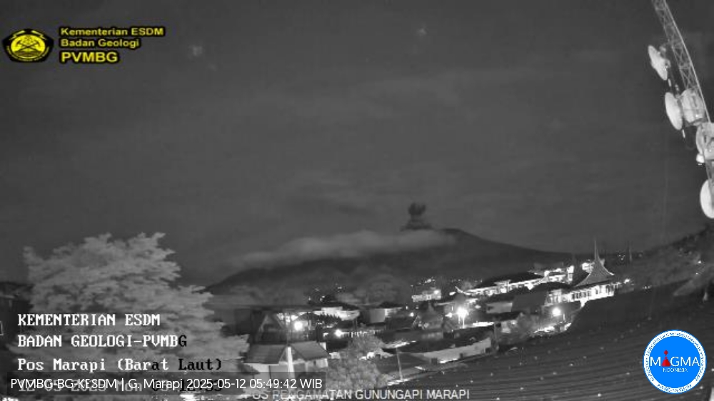
Indonesia , Marapi :
An eruption of Mount Marapi occurred on Monday, May 12, 2025, at 03:10 WIB with an observed ash column height of ± 600 m above the peak (± 3491 m above sea level). The ash column was observed to be gray in color with a thick intensity, oriented toward the Southeast. This eruption was recorded on a seismograph with a maximum amplitude of 30.3 mm and a duration of 30 seconds.
VOLCANO OBSERVATORY NOTICE FOR AVIATION – VONA
Issued : May 11 , 2025
Volcano : Marapi (261140)
Current Aviation Colour Code : YELLOW
Previous Aviation Colour Code : yellow
Source : Marapi Volcano Observatory
Notice Number : 2025MAR041
Volcano Location : S 0 deg 22 min 52 sec E 100 deg 28 min 23 sec
Area : West Sumatra, Indonesia
Summit Elevation : 9251 FT (2891 M)
Volcanic Activity Summary :
Increasing in volcanic activity.
Volcanic Cloud Height :
Best estimate of ash-cloud top is around 11171 FT (3491 M) above sea level or 1920 FT (600 M) above summit. May be higher than what can be observed clearly. Source of height data: ground observer.
Other Volcanic Cloud Information :
Ash cloud moving to southeast. Volcanic ash is observed to be gray. The intensity of volcanic ash is observed to be thick.
Remarks :
Eruption recorded on seismogram with maximum amplitude 30.3 mm and maximum duration 30 second. Tremor recorded on seismogram with maximum amplitude 1.5 mm.
Source et photo : Magma Indonésie
Chile , Villarica :
Seismology
The seismological activity for the period was characterized by the recording of:
4 VT-type seismic events, associated with rock fracturing (Volcano-Tectonic). The most energetic earthquake had a local magnitude (LM) value of 0.4, located 5.2 km east-northeast of the volcanic structure, at a depth of 4.4 km.
2,360 LP-type seismic events, associated with fluid dynamics within the volcanic system (Long Period). The size of the largest earthquake, evaluated using the reduced displacement (RD) parameter, was 17 cm².
77 TR-type seismic events, associated with sustained fluid dynamics within the volcanic system (TRemor). The size of the largest earthquake, evaluated using the reduced displacement (RD) parameter, was 6 cm².
Fluid Geochemistry
Sulfur dioxide (SO2) emission data obtained using Differential Optical Absorption Spectroscopy (DOAS) equipment at the Los Nevados and Tralco stations, located 10 km east-northeast and 6 km east-southeast of the active crater, respectively, showed an average value of 413 ± 55 t/d for the month of April. These values are considered normal for this volcanic system. The maximum daily average for the month was 1,143 t/d on April 29.
No anomalies in sulfur dioxide (SO2) emissions into the atmosphere have been reported in the area near the volcano, according to data published by the Tropospheric Monitoring Instrument (TROPOMI) and the Ozone Monitoring Instrument (OMI) Sulfur Dioxide Group.

Thermal Anomalies from Satellites
During the period, no thermal alerts were recorded according to data processed by the MODIS sensor of the Volcanic Activity Observation Platform in the mid-infrared. Furthermore, according to analytical processing of Sentinel 2-L2A and Landsat 8-9 satellite images, in combination with false-color bands, thermal radiation from the crater was intermittently identified, with a maximum area of 2,000 m² on April 19, according to the Normalized Hotspot Indices algorithm (Marchese et al., 2019).
Activity remained at levels considered low, suggesting the volcano’s stability. The technical volcanic alert remains in effect for:
GREEN TECHNICAL ALERT: Active volcano with stable behavior – No immediate risk
Observation:
Monitoring of the volcano’s surface and instrumental activity indicates a decrease in the frequency of explosions with the emission of high-temperature volcanic material outside the crater. Given that this is an open-conduit volcanic system, sudden explosions without precursors cannot be ruled out. Consistent with previous observations, the impact of these explosions is mainly concentrated at distances less than 500 m, measured from the crater center. However, in the current scenario, the low surface activity and declining monitoring parameters suggest a low probability of this type of activity occurring. Associated risks include the ejection of ballistic pyroclasts and the emission of ash and volcanic gases.
Source : Sernageomin
Photo : in-cyprus. Philenews. com/
Ecuador , Sangay :
DAILY STATUS REPORT OF SANGAY VOLCANO, Sunday, May 11, 2025.
Information Geophysical Institute – EPN.
Surface Activity Level: High, Surface Trend: No Change
Internal Activity Level: Moderate, Internal Trend: No Change
Seismicity: From May 10, 2025, 11:00 a.m. to May 11, 2025, 11:00 a.m.:
Seismicity:
Below is the count of seismic events recorded at the reference station.
Explosion (EXP): 33
Rainfall/Lahars:
Since yesterday afternoon, no rain has been recorded in the volcano area. **Heavy rains could remobilize accumulated material, generating mud and debris flows that would cascade down the volcano’s flanks and flow into adjacent rivers**.
Emission/Ash Column:
Due to weather conditions, no gas or ash emissions were recorded in the past 24 hours using surveillance cameras and satellite systems. Furthermore, the Washington-based WAAC agency issued two reports of gas and ash emissions moving westward and at altitudes below 1,200 meters above the crater level.
Observation:
The volcano remained completely cloudy over the past 24 hours.
Alert Level: Yellow
Source : IGEPN
Photo : lenin.izaa via Volcan Sangay / FB.
Guatemala , Santiaguito :
Weather: Clear.
Wind: Northeast.
Precipitation: 93 mm.
Activity:
Activity is reported from the Caliente dome of the Santa María-Santiaguito volcanic complex, characterized by white outgassing reaching an approximate height of 400 meters above the crater level. The monitoring network of seismic and acoustic sensors is identifying weak to moderate explosions, which can generate columns of gas and ash rising up to 3,500 meters above sea level (10,498 feet). The ash can spread 15 to 30 km southward, causing fine ashfall on farms and communities near the volcano.

During the night and early morning, intense incandescence was observed in the dome’s crater. Collapses and the descent of flaming volcanic material also occurred on the southeast, south, and southwest flanks of the dome. Activity remains high, so it is possible that due to the accumulation of material, explosions, or the action of gravity, new collapses could occur, generating large-scale pyroclastic flows towards the southwest, south, and southeast.
Source : Insivumeh
Photo : Armando Pineda