April 24 , 2025 .
Italy / Sicily , Etna :
Etna Activity Report, April 23, 2025, 8:05 AM (6:05 UTC)
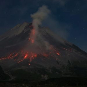
The National Institute of Geophysics and Volcanology, Osservatorio Etneo, reports that, according to surveillance cameras, the eruptive activity at the Southeast Crater, reported in the previous press release, gradually decreased starting around 3:00 UTC.
Currently, the Strombolian activity has ended, and the lava flow is no longer being fed and is cooling.
From a seismic perspective, the average amplitude of the volcanic tremor ended its upward trend at 7:40 PM UTC, reaching its maximum value.
Subsequently, a downward trend began, although values remained high until 1:50 UTC today. The amplitude reached low values at 03:10 UTC, a level at which it is still maintained. The location of the centroid of the volcanic tremor source was not always available due to technical issues. When the location was reliable, during the eruptive episode, it was located near the Southeast Crater, at an altitude of approximately 2,900 m. It is currently located near the Northeast Crater, at an altitude of approximately 1,800 m. Infrasound activity was located at the Southeast Crater from 18:14 to 00:29 UTC today, and numerous high-amplitude events were observed. Currently, weak infrasound activity is being recorded at the Northeast Crater.
Data from the inclinometer and GNSS ground deformation monitoring networks do not show any significant variations.
Updates will be provided shortly.
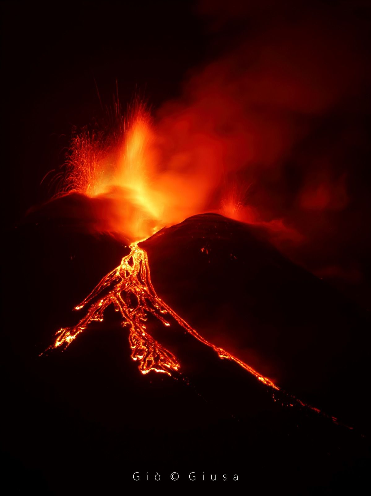
The Sezione di Catania – Osservatorio Etneo (INGV) reported continuing activity at Etna during 14-20 April with two episodes of Strombolian activity at SE Crater. The first episode began at 09h00 on 15 April and progressively intensified until about 11h30, when lava overflowed the crater and descended the SE flank; activity ceased at 11h50. The lava flow was about 1.2 km long and reached 2,620 m elevation based on 17 and 18 April satellite images. The second episode began at 19h05 on 18 April and progressively intensified until about 23h30, with two lava flows overflowing the crater; one descended the SE flank along the same path as the 15 April flow, and the other descended the SW flank. Activity ceased at 00h55 on 19 April.
Sources : INGV , GVP.
Photo : Gio Giusa.
Japan , Kuchinoerabujima :
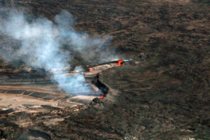
The Japan Meteorological Agency (JMA) reported that the number of shallow volcanic earthquakes increased beneath an area near Kuchinoerabujima’s Furudake Crater with 100 earthquakes recorded during 7-16 April. No changes to geothermal areas located in and around both Shindake and Furudake craters were observed during a field survey conducted on 11 April. Sulfur dioxide emissions were low, averaging 20 tons per day on 11 April, and no ground deformation had been detected since November 2023. The Alert Level was raised to 2 (on a scale of 1-5) at 23h25 on 16 April; the public was warned that ejected blocks may land within 1 km of both craters, and pyroclastic flows may affect areas within 2 km of the W flank of Shindake Crater.
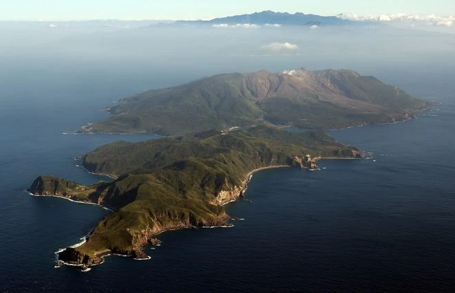
A group of young stratovolcanoes forms the eastern end of the irregularly shaped island of Kuchinoerabujima in the northern Ryukyu Islands, 15 km W of Yakushima. The Furudake, Shindake, and Noikeyama cones were erupted from south to north, respectively, forming a composite cone with multiple craters. All historical eruptions have occurred from Shindake, although a lava flow from the S flank of Furudake that reached the coast has a very fresh morphology. Frequent explosive eruptions have taken place from Shindake since 1840; the largest of these was in December 1933. Several villages on the 4 x 12 km island are located within a few kilometers of the active crater and have suffered damage from eruptions.
Sources: Japan Meteorological Agency (JMA), GVP.
Photo : Asahi Shimbun.
Iceland , Reykjanes Peninsula :
Uplift continues beneath Svartsengi but the rate has decreased
22.4.2025
The rate of deformation at Svartsengi has decreased
Considerable micro-earthquake activity is still being recorded near the dike intrusion
The hazard assessment has been updated and is valid until May 6, assuming no changes
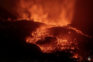
Uplift in Svartsengi continues, but the rate has significantly decreased and is now similar to the period before the eruption that began on April 1. As magma accumulation continues beneath Svartsengi, repeated magma intrusions and even eruptions in the Sundhnúkur crater row must be considered.
The Icelandic Meteorological Office continues to monitor the development of magma accumulation and assess possible scenarios based on the latest data.
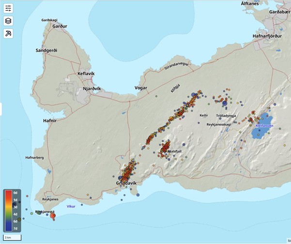
The map shows reviewed earthquakes on the Reykjanes Peninsula over the past week. Most of the earthquakes were located near the magma intrusion that was formed on April 1st and in the western part of Fagradalsfjall. The color differences of the points indicate the timing of the earthquakes, with the reddish points marking earthquakes that happened in the past day and the blue ones about a week ago.
Micro-earthquake activity continues near the magma intrusion that formed on April 1, with an average of about one hundred earthquakes per day in the past week. Most of the earthquakes are below magnitude 1, with the largest one recorded at magnitude 1.7 during the past week. There was also some minor earthquake activity near Fagradalsfjall last weekend. Calm weather in recent days has allowed the monitoring network to detect even the smallest earthquakes that would otherwise likely not be recorded due to weather noise.
Source et photo: IMO.
Costa Rica , Poas :
The Observatorio Vulcanológico y Sismológico de Costa Rica-Universidad Nacional (OVSICORI-UNA) reported frequent explosions and ash-and-gas plumes at Poás during 16-22 April. Weather clouds often prevented visual observations, though during daily periods of clearer weather the plumes were confirmed to have contained ash. Both seismic and acoustic data indicated that frequent small eruptions at varying intensities occurred through the week, a change from the continuous activity of the previous week; activity generally began decreasing on 11 April. Ash emissions rose around 200 m above the crater rim and drifted SW and WSW, primary from Boca C during the first part of the week, then from Boca A starting on 20 or 21 April. Incandescence at Boca A was sometimes visible during dark hours. Energetic explosions ejected blocks as high as the crater rim. Sulfur dioxide emissions measured by a Differential Optical Absorption Spectroscopy (DOAS) station averaged 230-439 tons per day (t/d), though the average was 1,217 t/d on 17 April.
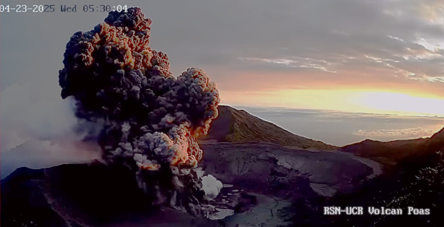
Notably, a strong explosive phase began at 1414 on 21 April and lasted for five minutes. A dense ash plume from Boca A rose 4.5 km above the crater rim and drifted SW, and hot ballistics (around 250 degrees Celsius) were ejected to the W. Weather clouds prevented clear views of the plume. According to a news article ash, gas, and incandescent material were ejected. Ash fell across the Valle Central to the SW, including in Zarcero (18 km W), Grecia (16 km SW), Alajuela (20 km S), Heredia (28 km SE), and San José (33 km SE), and on social media residents posted photos of ashfall on the streets, cars, and homes. Lower-energy ash emissions continued through the rest of the day, generating brown ash plumes at 15h54, 16h28, and 17h21. Small eruptive events were recorded on 22 April. That same day field measurements of the gas emissions using a DOAS instrument yielded an average that exceeded 1,000 t/d. The volcano’s Alert Level remained at 3 (the second highest level on a four-level scale) and the Aviation Color Code remained at Orange (the second highest color on a four-color scale).
Sources: Observatorio Vulcanologico y Sismologico de Costa Rica-Universidad Nacional (OVSICORI-UNA), Tico Times , GVP.
Photo : RSN-UCR ( capture d’écran)
Colombia , Puracé – Chaîne volcanique Los Coconucos :
Popayán, April 22, 2025, 4:00 p.m.
Regarding the monitoring of the activity of the Puracé Volcano – Los Coconucos Volcanic Chain, the Colombian Geological Survey (SGC), an entity affiliated with the Ministry of Mines and Energy, reports that:
During the week of April 15-21, seismic activity followed a similar trend to that observed the previous week, both in terms of the number of events recorded daily and the energy levels released.
Earthquakes associated with rock fracturing were mainly located between the Puracé and Piocollo volcanoes, at depths between 1 and 3 km, and reached a maximum magnitude of 1.6. Also noteworthy is an earthquake recorded on April 20, 5 km southwest of the crater of the Puracé volcano, with a magnitude of 2.2. Fluid dynamic events were concentrated mainly beneath the crater of the Puracé volcano, at depths less than 1 km, and were characterized by their low energy.
Moderate levels of sulfur dioxide (SO₂) and carbon dioxide (CO₂) emissions were recorded by satellite and field instruments. Furthermore, the slow deformation process continued between the Puracé, Piocollo, and Curiquinga volcanic edifices.
In images captured by visible and infrared webcams, degassing processes continued to be observed in the lateral fumarole and within the crater of Puracé Volcano, characterized by gas columns reaching up to 1 km above the summit of the volcanic chain. In conclusion, continuous degassing from the lateral fumarole and crater of Puracé Volcano continued throughout the week, accompanied by localized seismic activity beneath the edifice of the Puracé and Piocollo volcanoes. Moderate emissions of volcanic gases (SO₂ and CO₂) and slow ground deformation were observed, indicating the persistence of an active volcanic system. In the event of a yellow alert, phenomena such as sporadic ash emissions (minor eruptions of limited magnitude and impact, whose dispersion depends on wind direction), the presence of incandescence, small explosions in the crater, low-energy thermal anomalies, noise, felt earthquakes, odors, precipitation of elemental sulfur near the crater, in hot springs and fumaroles, as well as degassing outside the crater, may also occur. Fissure formation and the occurrence of minor lahars, among other things, may also occur.
Based on the above, the SGC recommends closely monitoring the evolution of volcanic activity through weekly bulletins and other information published on official channels, as well as following the instructions of local and departmental authorities and the National Disaster Risk Management Unit (UNGRD). The alert status for volcanic activity remains at Yellow: Active volcano, with changes in the baseline level of monitored parameters and other manifestations.
Source et photo : SGC.