April 16 , 2025.
Italy / Sicily , Etna :
WEEKLY BULLETIN, from April 7, 2025 to April 13, 2025. (Issue date April 15, 2025)
SUMMARY OF ACTIVITY STATUS
Based on monitoring data, the following are highlighted:
1) VOLCANOLOGICAL OBSERVATIONS: Strombolian activity at the Southeast Crater, degassing at the Bocca Nuova, Voragine, and Northeast Craters.
2) SEISMOLOGICAL OBSERVATIONS: No seismic activity due to fracturing with Ml>=2.0. Tremor amplitude at low levels, except for the two episodes of Strombolian activity.
3) INFRASOUND: Infrasound activity is mainly low or medium; high during the two episodes of Strombolian activity. 4) GROUND DEFORMATION: Over the past week, ground deformation monitoring networks have not recorded any significant variations. Two very modest decompressions were recorded by the DRUV borehole dilatometer during the Strombolian phases of April 8 and 11. 5) GEOCHEMISTRY: SO2 flux at an average level
The soil CO2 flux remains at average values
The partial pressure of dissolved CO2 in the aquifer (Ponteferro) is not updated for technical reasons
The helium isotope ratio in the peripheral sites is medium-high (last updated 03/04/2025)
6) SATELLITE OBSERVATIONS: The thermal activity observed by satellite in the summit area was generally low, with high to very high values corresponding to the eruptive activity of the Southeast Crater on April 7, 2025, and April 11, 2025.
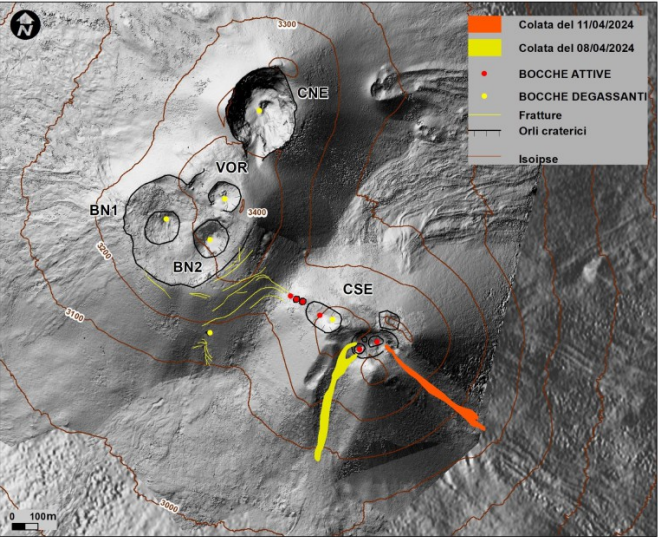
Map of the summit area of Etna and the lava flows of April 8 and 11 (in yellow and red respectively), superimposed on the shaded relief of the terrain obtained by processing images acquired by drone between February, March and April 2025 for BN and CSE, on September 12, 2024 for VOR and CNE. Geoidal contour lines are plotted every 100 meters. Degassing vents are shown in yellow. CSE = Southeast Crater, CNE = Northeast Crater, VOR = Voragine, BN = Bocca Nuova
VOLCANOLOGICAL OBSERVATIONS
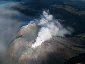
During the week, volcanic activity in Etna’s summit craters was monitored through the analysis of images acquired by surveillance cameras at the National Institute of Geophysics and Volcanology – Osservatorio Etneo (INGV-OE) and through direct observations made by INGV-OE personnel on April 12. During the period studied, the summit craters were characterized by Strombolian activity at the Southeast Crater (CSE) and degassing activity at the Voragine (VOR), Bocca Nuova (BN), and Northeast (CNE) craters.
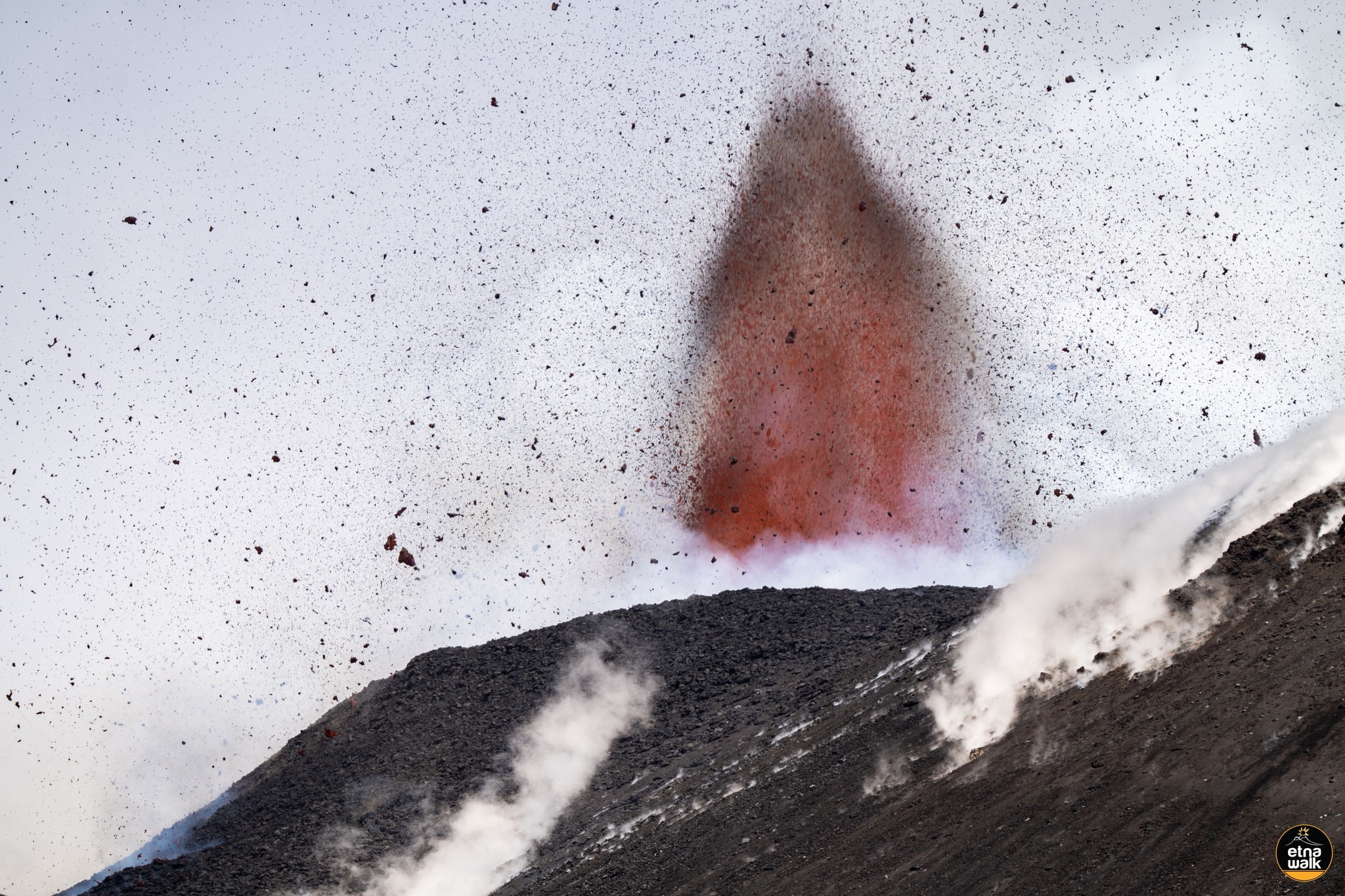
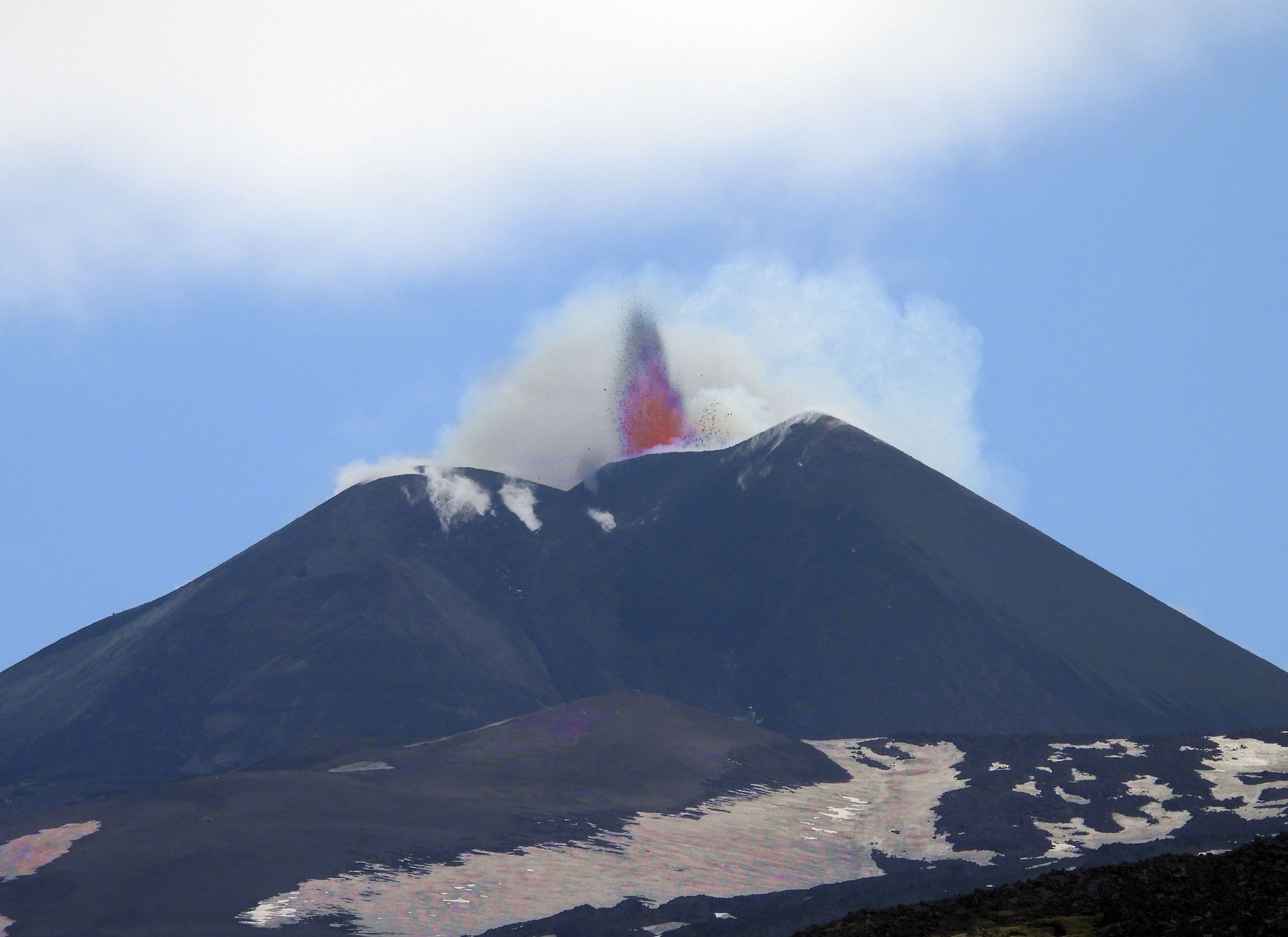
In detail, the Southeast Crater showed eruptive activity on April 7-8 and 11, these events represent the 6th and 7th episode of a sequence that began on March 15, 2025. The typical eruptive activity of these episodes consists of transients of Strombolian activity with an average duration of 7h30 with a frequency of occurrence of about 4 days from each other. The episodes develop with Strombolian activity that progressively increases in intensity and frequency of explosions, with the consequent launch and distribution of projections beyond the rim of the crater and along the sides of the cone itself. In the culminating phases of the activity, the ash produced by the explosions tends to become continuous and intense so as to produce modest eruptive clouds with episodic and light ash fallout in the distal area. The activity is often accompanied by effusive activity from lava overflow from the Southeast Crater; the flows progress slowly, with the fronts generally stopping at the base of the crater itself.
Below is a timeline of the April 7, 8, and 11 episodes. Times are in GMT.
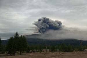
The April 7-8 episode began around 11:00 PM on the 7th with a gradual increase in explosive activity, producing a volcanic ash cloud that dispersed in a southeasterly direction, with fallout in Catania and Nicolosi. At 12:40 AM on April 8, active effusive activity began, initiating a lava flow on the southern flank of the crater cone. The event ended at 8:20 AM on April 8. The lava flow mapped by analysis of a Skysat image from April 11th has an area of 0.14 x 10⁵ m², a length of approximately 500 m, and the front reached an altitude of approximately 3,090 m above sea level.
The April 11th episode began at 2:00 p.m., but this estimate is uncertain due to weather conditions that prevented observation of the summit area in the preceding hours. In this case, too, the dynamics are similar to previous ones, with an overflowing lava flow progressing from 8:00 p.m. on the eastern side of the crater cone and stopping simultaneously with the end of explosive activity around midnight. The eruptive cloud is dispersed in the southeast quadrant of Etna, with light ashfall in the area of Lavinaio, Acireale, and Aci Sant’Antonio. The lava flow, mapped using Skysat images on April 12, has an area of 0.12 x 10⁵ m², a length of approximately 510 m, and the front reached an altitude of approximately 3,020 m above sea level.
Etna Activity Update, April 15, 2025, 09:49 (07:49 UTC)
The National Institute of Geophysics and Volcanology, Osservatorio Etneo, reports that, starting at 07:00 GMT, Strombolian activity can be observed by INGV-OE surveillance cameras in the southeast crater. The forecast model indicates that any eruptive clouds produced by the ongoing eruptive activity would disperse in a northeasterly direction.
From a seismic perspective, the amplitude of the volcanic tremor since 02:00 UTC today has shown a continuous increase. The amplitude reached its highest values at 07:00 UTC and continues to increase. The location of the tremor sources corresponds to the Southeast Crater, at an altitude of approximately 2,900 meters above sea level.
Counting infrasound events is not very reliable due to the strong winds present in the summit area. However, the few localized events are located in the Southeast Crater (SEC) area, with a high amplitude.
At present, ground deformation monitoring networks do not show significant variations in tilt and GNSS sensors.
Further updates will be provided shortly.
Source : INGV
Photos : INGV , Giuseppe Distefano , Boris Behncke
Italy , Stromboli :
WEEKLY BULLETIN, from April 7, 2025 to April 13, 2025. (Issue date April 15, 2025)
SUMMARY OF ACTIVITY STATUS
Based on monitoring data, the following is highlighted:
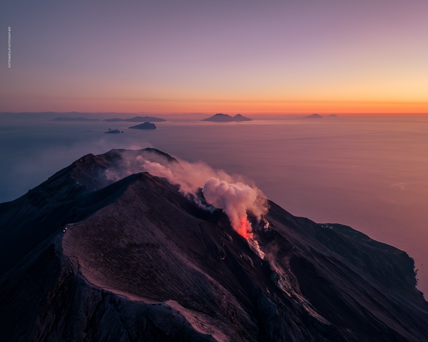
1) VOLCANOLOGICAL OBSERVATIONS: During this period, ordinary Strombolian eruptive activity was observed. The total hourly frequency ranged from average values (11 events/h) to high values (18 events/h). The intensity of the explosions was low and medium in the North and South-Central crater areas.
2) SEISMOLOGY: The monitored seismic parameters do not show any significant variations.
3) GROUND DEFORMATION: The island’s ground deformation monitoring networks did not show any significant variations to report for the period under review. 4) GEOCHEMISTRY: SO2 flux at medium levels
Soil CO2 flux from the Pizzo area (STR02): very high values.
C/S ratio in the plume: remains at high values.
Dissolved helium isotope ratio (R/Ra) in thermal aquifers: at the threshold between medium and high values.
CO2 flux at Mofeta in the San Bartolo area: medium-high values.
Soil CO2 flux in the Scari area at medium values.
5) SATELLITE OBSERVATIONS: Thermal activity observed by satellite in the summit area was generally low.
VOLCANOLOGICAL OBSERVATIONS
During the observation period, Stromboli’s eruptive activity was characterized by analyzing images recorded by INGV-OE surveillance cameras located at an altitude of 190 m (SCT-SCV) and at Punta dei Corvi (SPCT). Explosive activity was produced mainly by four eruptive vents located in the northern area of the crater and by at least two vents located in the central-southern area.
Observations of explosive activity captured by surveillance cameras
In the northern (N) crater area, four active vents were observed, producing low-intensity explosive activity (less than 80 m in height) and sometimes medium-intensity explosive activity (less than 150 m in height). The ejected products consisted mainly of coarse materials (bombs and lapilli). The average explosion frequency ranged from 5 to 15 events/h. In the South-Central (SC) area, explosive activity was produced by at least two vents. The explosions were mainly of low and medium intensity, emitting fine materials (ash) mixed with coarse materials (lapilli and bombs). The average explosion frequency ranged from 1 to 7 events/h.
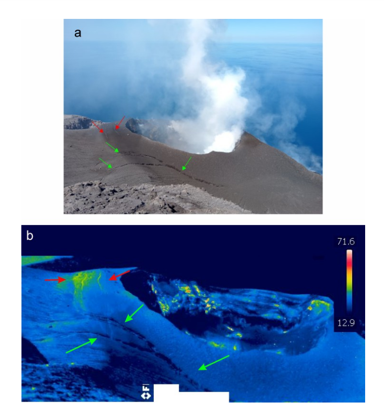
Visible and thermal images, a and b respectively, of the southern crater area as seen from Pizzo. The green and red arrows indicate the two fracture systems observed.
Observations during the inspection on April 10, 2025.
On the morning of April 10, INGV-OE personnel, as part of the DPC-INGV implementation agreement and the UN Departmental Project, conducted an inspection in the summit area (Pizzo sopra la Fossa) to characterize the morphostructural changes of the crater terrace, the explosive activity, and to recover the instrumentation and the volcanic ash sampler.
During the inspection, it was observed that the fractures around the southwest crater had widened compared to the last survey on October 2, 2024. The observations made with the thermal camera allowed us to verify that these fractures are cold (Fig. 3). The presence of two other fractures with an approximately East-West orientation was also noted, associated with a relatively insignificant thermal anomaly (red arrows). As for the South-West crater, it seems to have widened following the collapses of the North-East rim, to the point that the separation septum between the two zones of the crater appears very thin and frayed in the summit part.
Source : INGV
Photo : Stromboli stati d’animo / Sebastiano Cannavo , INGV.
Iceland , Reykjanes Peninsula :
Uplift continues beneath Svartsengi
The rate of deformation at Svartsengi has decreased
Seismic activity over the dike intrusion is declining
A new version of the hazard assessment map takes effect today, April 15
Minor seismic activity is still being recorded around the dike intrusion that formed on April 1, with dozens of earthquakes occurring daily in the area. The largest earthquake over the past week was a magnitude 3.3 on April 13, located over the northern part of the dike intrusion, about 4 km ENE of Keilir. Most of the earthquakes are under magnitude 2 and at depths of 2 to 6 km.
Uplift at Svartsengi continues, though the rate has slowed compared to last week. The current rate is about twice as fast as it was just before the last eruption, and is similar to the rate observed at the start of the current eruption cycle that began in 2024.
The Icelandic Meteorological Office continues to monitor the area, track magma accumulation, and assess possible scenarios based on the latest data. As long as magma continues to accumulate beneath Svartsengi, repeated magma intrusions and even eruptions along the Sundhnúkur crater row must be considered possible.
New hazard map covering a larger area
Today, a new version of a hazard map is published and distributed by the Icelandic Meteorological Office to inform and report on the level of hazard due to the ongoing unrest in the Reykjanes peninsula. This map replaces the previous hazard map that has been in use and published since November 2023, which showed hazard assessments for seven well-defined zones near the activity around the Sundhnúkur crater row.
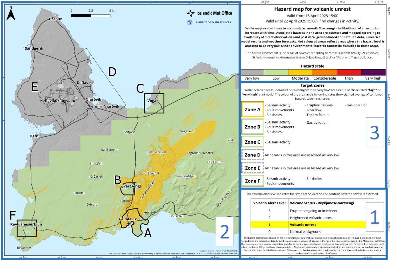
The seven-zone map has been updated and issued 108 times since November 20, 2023. While it had its strengths, its limitations included difficulty in assessing hazards outside the defined zones.
Recent developments on the peninsula, where a magma intrusion formed and reached the northeastern part of the Svartsengi volcanic system on April 1, 2025, and an eruption that occurred west of the northernmost part of Fagradalsfjall in August 2024, highlight the need for a hazard assessment that covers a larger area.
A new map has therefore been developed to address the limitations of the previous version. This new approach is not only applicable to the Reykjanes Peninsula but also introduces a methodology that can be used for all other active volcanic systems in Iceland.
Source : IMO
Photos : Stóra-Skógfel /Protection civile/Björn Oddsson , IMO.
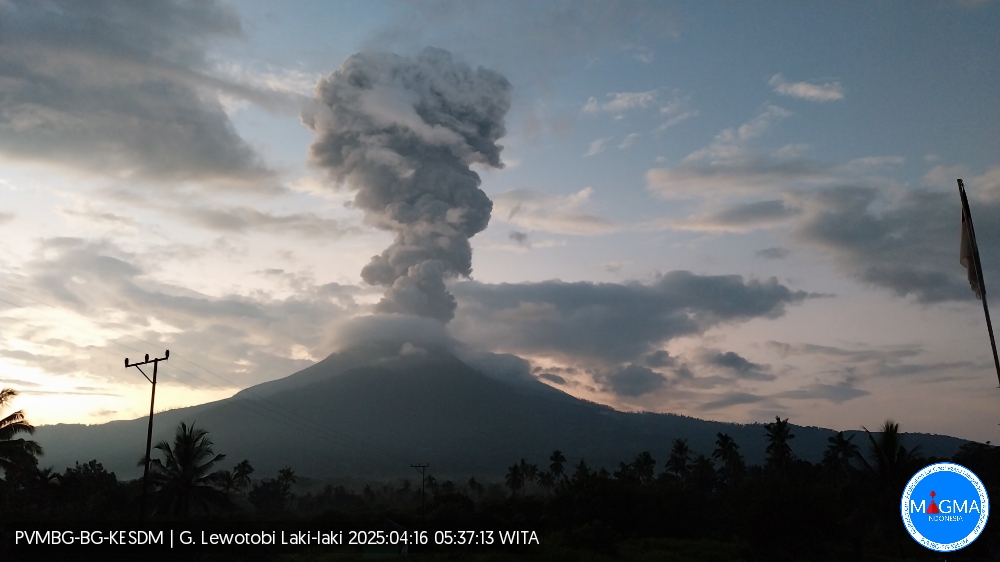
Indonesia , Lewotobi Laki-laki :
An eruption of Mount Lewotobi Laki-laki occurred on Wednesday, April 16, 2025, at 05:33 WITA with an observed ash column height of ± 3500 m above the peak (± 5084 m above sea level). The ash column was observed to be gray in color with a thick intensity, oriented toward the west and northwest. At the time of writing, the eruption was still ongoing.
VOLCANO OBSERVATORY NOTICE FOR AVIATION – VONA
Issued : April 15 , 2025
Volcano : Lewotobi Laki-laki (264180)
Current Aviation Colour Code : ORANGE
Previous Aviation Colour Code : orange
Source : Lewotobi Laki-laki Volcano Observatory
Notice Number : 2025LWK198
Volcano Location : S 08 deg 32 min 20 sec E 122 deg 46 min 06 sec
Area : East Nusa Tenggara, Indonesia
Summit Elevation : 5069 FT (1584 M)
Volcanic Activity Summary :
Eruption with volcanic ash cloud at 21h33 UTC (05h33 local).
Volcanic Cloud Height :
Best estimate of ash-cloud top is around 16269 FT (5084 M) above sea level or 11200 FT (3500 M) above summit. May be higher than what can be observed clearly. Source of height data: ground observer.
Other Volcanic Cloud Information :
Ash cloud moving from west to northwest. Volcanic ash is observed to be gray. The intensity of volcanic ash is observed to be thick.
Remarks :
Eruption recorded on seismogram with maximum amplitude 47.3 mm and maximum duration 302 second.
Source et photo : Magma Indonésie .
Colombia , Purace – Los Coconucos volcanic chain :
Popayán, April 15, 2025, 4:20 p.m.
According to monitoring of the activity of the Puracé volcano – Los Coconucos volcanic chain, the Colombian Geological Survey (SGC), an entity affiliated with the Ministry of Mines and Energy, reports that:
During the week of April 8-14, seismic activity associated with rock fracturing and fluid dynamics decreased compared to previous weeks. The fracturing events were located mainly in two areas: to the northeast of the Puracé volcano, at a distance of between 2 and 6 km from the summit of the volcanic edifice, with magnitudes below 1.8 and depths of between 3 and 6 km; and between the structures of the Puracé and Piocollo volcanoes, with depths between 0.5 and 2 km and magnitudes less than 1.
Seismic activity associated with fluid dynamics in the volcanic conduits was mainly located between the structures of the Puracé, Piocollo, and Curiquinga volcanoes, with depths less than 3 km and low magnitudes.
Moderate sulfur dioxide (SO2) and carbon dioxide (CO2) emissions were recorded by satellite and field instruments, with more significant degassing on April 8. Furthermore, the slow deformation process continued between the Puracé, Piocollo, and Curiquinga volcanic edifices. In images captured by visible and infrared webcams, degassing processes continued to be observed in the lateral fumarole and inside the crater of the Puracé volcano, characterized by gas columns that reached heights of 1.5 km above the summit of the volcanic chain on April 8. On the 9th, a low-energy thermal anomaly was detected by satellite inside the crater of the Puracé volcano.
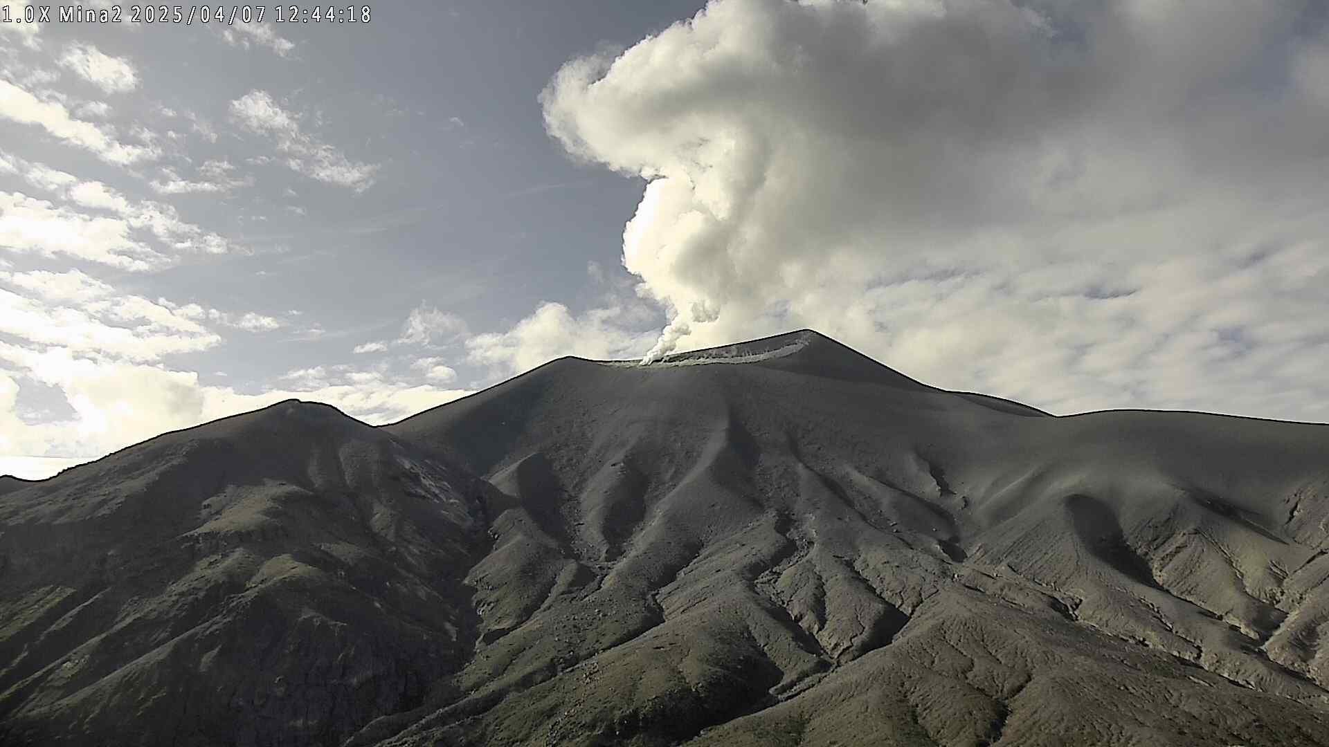
It is concluded that degassing continues to occur in the lateral fumarole and crater of the Puracé volcano, as well as seismic activity beneath the edifice of the Puracé, Piocollo, and Curiquinga volcanoes, slow deformation changes, and surface thermal anomalies.
Under Yellow alert status, phenomena such as sporadic ash emissions (minor eruptions of limited magnitude and effects, whose dispersion depends on wind direction), the presence of incandescence, small explosions in the crater, low-energy thermal anomalies, noise, felt earthquakes, odors, precipitation of elemental sulfur near the crater and in hot springs and fumaroles, as well as degassing in areas other than the crater, may occur. Fissure formation and the appearance of minor lahars, among other things, are also observed. Based on the above, the SGC recommends closely monitoring the evolution of volcanic activity through weekly bulletins and other information published on official channels, as well as heeding the instructions of local and departmental authorities and the National Disaster Risk Management Unit (UNGRD).
The alert status for volcanic activity remains at yellow alert: active volcano with changes in the behavior of the baseline level of monitored parameters and other manifestations.
Source et photo : SGC