April 9 , 2025.
Hawaii , Kilauea :
HAWAIIAN VOLCANO OBSERVATORY STATUS REPORT / U.S. Geological Survey
Tuesday, April 8, 2025, 2:52 AM HST (Tuesday, April 8, 2025, 12:52 UTC)
19°25’16 » N 155°17’13 » W,
Summit Elevation 4091 ft (1247 m)
Current Volcano Alert Level: WATCH
Current Aviation Color Code: ORANGE
Activity Summary:
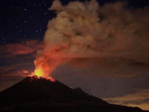
Episode 17 of the ongoing Halemaʻumaʻu eruption began at 10:15 p.m. HST on April 7, 2025 with the start of lava overflowing from the south vent.
Episode 17 was preceded by glow from the south vent that increased at about 9:20 p.m. HST on April 7 indicating the gradual rise of lava in the vent prior to the start of the eruption. Lava continues to overflow the vent spreading across the floor of Halema’uma’u and is being fed by low spatter fountains 15-30 feet high (5-10 meters) as of 2:50 a.m. HST on April 8. Each of the prior 16 episodes ultimately involved significant lava fountaining, with the fountains of episode 16 exceeding 1,000 feet (305 meters) in height. High lava fountains are likely to follow the current low fountaining and lava flows.
UWD tilt has started slight deflation at about the same time lava began erupting. Seismic tremor initially began increasing around 10:00 p.m. HST on April 7 and continues to steadily increase.
Emissions of SO2 gas are elevated, and during recent episodes have reached 50,000 tonnes per day or more, and similar amounts of gas are expected to accompany any high fountaining activity that may occur during episode 17. In addition, visitors to Hawaiʻi Volcanoes National Park and residents of adjacent areas may be exposed to Peleʻs hair and other small fragments of volcanic glass and tephra being carried in the plume, as they were during episode 16.
Each episode of Halemaʻumaʻu lava fountaining since December 23, 2024, has continued for 13 hours to 8 days, and episodes have been separated by pauses in eruptive activity lasting less than 24 hours to 12 days.
information
No changes have been detected in the East Rift Zone or Southwest Rift Zone. HVO continues to closely monitor Kīlauea and will issue an eruption update tomorrow morning unless there are significant changes before then.
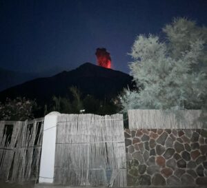
Following the onset of the Kīlauea summit eruption’s seventeenth episode in the late evening of April 7, USGS Hawaiian Volcano Observatory geologists visited the southern rim of Halemaʻumʻau crater on the morning of April 8 to observe vent activity. Unlike most of the recent eruptive episodes, this one has seen low-level lava fountains (only up to 100 feet, or 30 meters) at the south vent in conjunction with summit deflation, which has typically heralded taller fountains approaching several hundred feet in height.
Tuesday, April 8, 2025, 9:10 AM HST (Tuesday, April 8, 2025, 19:10 UTC).
Summit Observations:
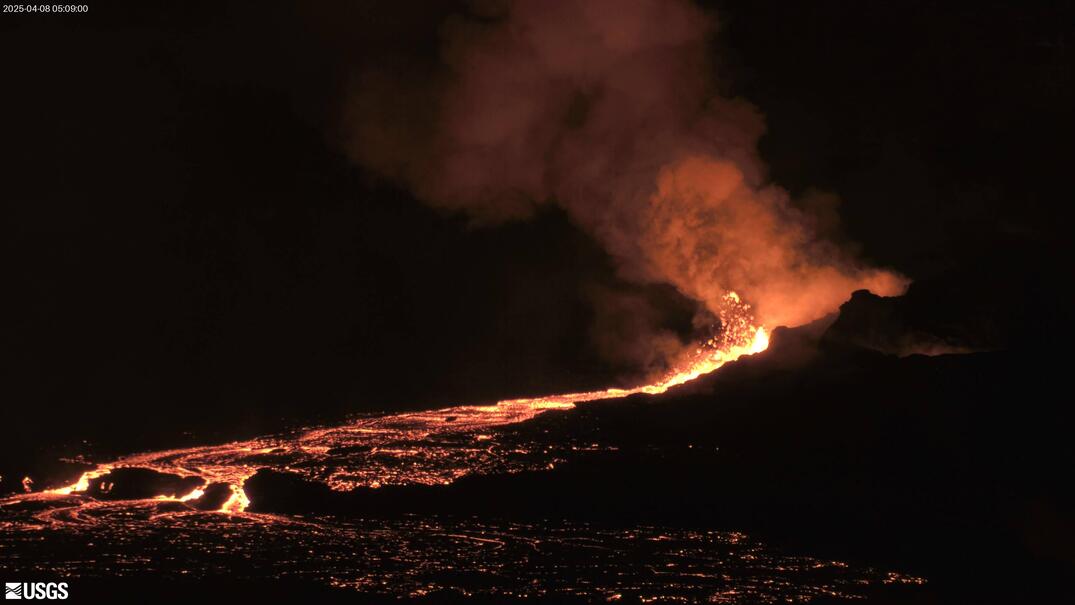
Low lava fountaining began last night at the south vent around 10:15 p.m. HST, and started to produce a small lava flow that spread across the crater floor. This morning, low fountaining (100 feet, or 30 meters) continues in the south vent, and has produced a lava flow covering about 20% of the crater floor. Spattering and lava pond activity became visible in the north vent at about 4 a.m. HST this morning.
The UWD and SDH tiltmeters show the onset of deflationary tilt around midnight, with deflationary tilt continuing this morning. UWD has had about 2.6 microradians of deflationary tilt since midnight. Seismic tremor began increasing last night with the onset of south vent activity and continues climbing this morning.
Volcanic gas emissions remain elevated, and at heightened levels due to lava fountaining. Sulfur dioxide (SO2) emission rates during earlier fountaining episodes have reached 50,000 t/d. This morning, the plume is being carried towards the southwest.
Source : HVO
Photos : USGS , USGS / M. Zoeller.
Italy / Sicily , Etna :
WEEKLY BULLETIN, from March 31, 2025 to April 6, 2025. (Issue date: April 8, 2025)
ACTIVITY STATUS SUMMARY
Based on monitoring data, the following are highlighted:
1) VOLCANOLOGICAL OBSERVATIONS: Strombolian activity at the Southeast Crater, volcanic ash emission at the Voragine and Bocca Nuova craters, and degassing activity at the Northeast Crater.
2) SEISMOLOGICAL: No seismic activity due to fracturing with Ml>=2.0. Tremor amplitude at low levels, except for the Strombolian activity episode.
3) INFRASOUND: Low infrasound activity, except for the Strombolian activity episode. 4) GROUND DEFORMATION: Over the past week, ground deformation monitoring networks have not recorded any significant changes.
5) GEOCHEMISTRY: SO2 flux at an average level.
The soil CO2 flux (Etna Gas Network) remains at average values.
Partial pressure of dissolved CO2 in the aquifer (Ponteferro). For technical reasons, no update is available.
Isotope ratio of peripheral sites: Latest data (11/03/2025) show medium-high values.
6) SATELLITE OBSERVATIONS: Thermal activity observed by satellite in the summit area was generally low, with high to very high values corresponding to the eruptive activity of the Southeast Crater on April 2, 2025, and April 8, 2025.
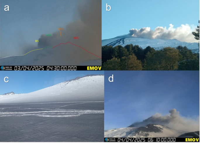
Volcanic ash emission from the Voragine crater observed by EMOV camera images a) on April 3 at 04:30 UTC, b) by INGV-OE personnel on April 3 at 06:05 UTC; deposit of fine materials observed by INGV-OE personnel in the summit area on April 3; d) volcanic ash emission visible from the EMOV camera on April 4.
VOLCANOLOGICAL OBSERVATIONS
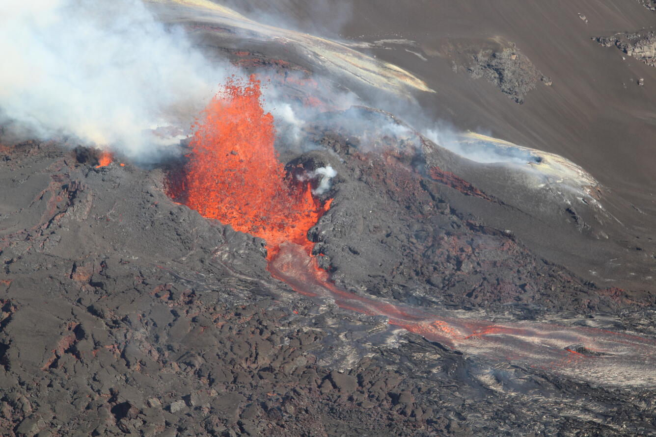
During the week, volcanic activity in Etna’s summit craters was monitored through the analysis of images acquired by the surveillance cameras of the National Institute of Geophysics and Volcanology – Osservatorio Etneo (INGV-OE), as well as through direct observations made by INGV-OE personnel on April 2, 3, and 4. Adverse weather conditions limited the continuity of volcanological observations through the camera network. During the study period, the summit craters were characterized by Strombolian activity at the Southeast Crater (SEC), volcanic ash emissions at the Voragine Crater (VOR), light and sporadic volcanic ash emissions at the Bocca Nuova Crater (BN), and degassing activity at the Northeast Crater.
Beginning around 19:00 UTC on April 2, weak and intermittent Strombolian activity was observed at the Southeast Crater (SEC), which showed a gradual increase over time. From 20:00 UTC, this activity was clearly visible in images acquired by INGV-OE video surveillance cameras. Subsequently, between 20:50 UTC and for approximately two hours,
Strombolian activity increased in intensity, depositing products also along the flanks of the Southeast Crater (SEC) cone.
In the following hours, the activity gradually decreased, eventually ceasing completely. Indeed, from 04:00 UTC onwards, the explosions were no longer visible on INGV-OE CCTV images.
In the early morning hours of April 2, volcanic ash was observed emitting from the Voragine Crater (VOR). The volcanic cloud reached a height of approximately 3.5 km above sea level and was transported mainly in a southeasterly direction. INGV-OE personnel present in the summit area also detected the presence of fine ash deposited on the snow. Further volcanic ash emissions were also observed in the early morning hours of April 4.
During the week, the Bocca Nuova (BN) crater was also characterized by sporadic and light emissions of reddish ash, observed by INGV-OE personnel in the field. The Northeast (CNE) crater, on the other hand, showed intense degassing activity.
Source : INGV
Photo : INGV . Capture d’écran 9 Avril 2025 .
Italy , Stromboli :
WEEKLY BULLETIN, from March 31, 2025 to April 6, 2025 (issue date April 8, 2025)
SUMMARY OF ACTIVITY STATUS
In light of monitoring data, the following is highlighted:
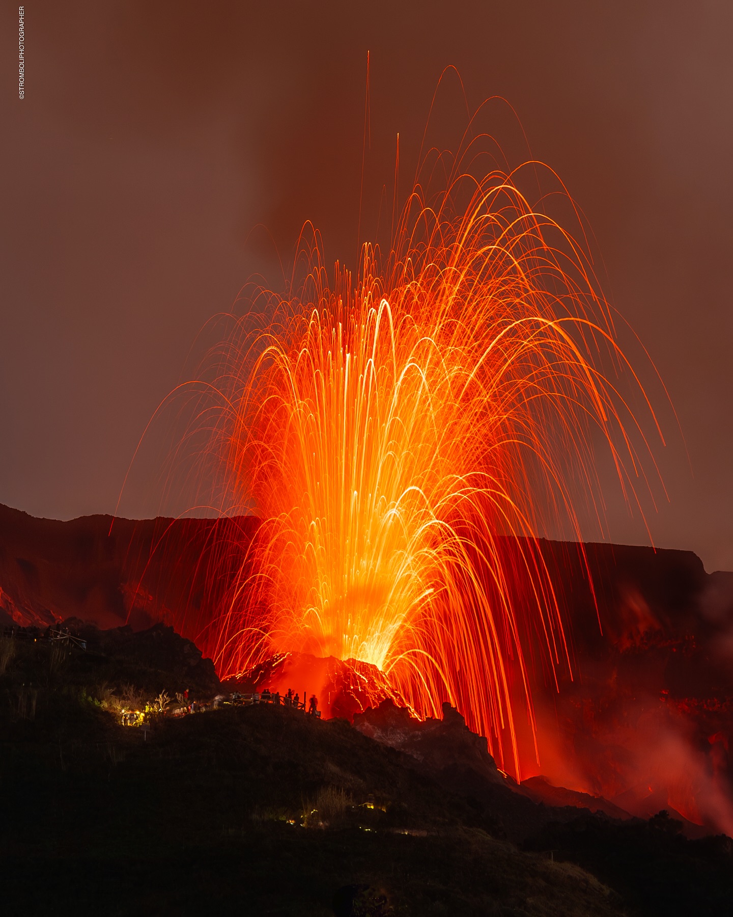
1) VOLCANOLOGICAL OBSERVATIONS: During this period, ordinary Strombolian eruptive activity was observed, accompanied by spattering activity in the N2 sector. The total hourly frequency ranged between average values (10-15 events/h). The intensity of the explosions was low and medium in the North and South-Central crater areas.
2) SEISMOLOGY: The monitored seismic parameters do not show any significant variations.
3) GROUND DEFORMATION: The island’s ground deformation monitoring networks did not show any significant variations to report for the period under review. 4) GEOCHEMISTRY: Soil CO2 fluxes in the Pizzo area (STR02): high values.
CO2/SO2 ratio in the plume (Stromboli Plume Network): average values.
Dissolved helium isotope ratio (R/Ra) in thermal aquifers: at the threshold between average and high values.
Soil CO2 fluxes in the San Bartolo area are average values.
Soil CO2 fluxes in the Scari area are average values.
5) SATELLITE OBSERVATIONS: Thermal activity observed by satellite in the summit area was generally low, with some isolated moderate thermal anomalies.
VOLCANOLOGICAL OBSERVATIONS
During the observation period, Stromboli’s eruptive activity was characterized by analyzing images recorded by INGV-OE surveillance cameras located at an altitude of 190 m (SCT-SCV) and at Punta dei Corvi (SPCT). The explosive activity was produced mainly by four eruptive vents located in the northern area of the crater and at least two vents located in the central-southern area.
Due to the adverse weather conditions on April 1st, visibility of the crater terrace was insufficient to accurately describe the eruptive activity.
Observations of explosive activity captured by surveillance cameras
In the North (N) crater area, four active vents were observed, producing low-intensity explosive activity (less than 80 m in height) and occasionally medium-intensity explosive activity (less than 150 m in height). In the N2 sector, discontinuous and weak ejection activity was observed, intense for short periods on March 31 and April 2. The ejected products consisted mainly of coarse materials (bombs and lapilli). The average explosion frequency ranged from 8 to 12 events/h.
In the South-Central (SC) area, explosive activity was produced by at least two vents. The explosions were mainly of low and medium intensity, emitting fine materials (ash) mixed with coarse materials (lapilli and bombs). The average explosion frequency ranged from 1 to 5 events/h.
Source : INGV
Photo : Stromboli stati d’animo / Sebastiano Cannavo
Philippines , Kanlaon :
KANLAON VOLCANO ERUPTION BULLETIN 08 April 2025 02:00 PM
Eruption Data:
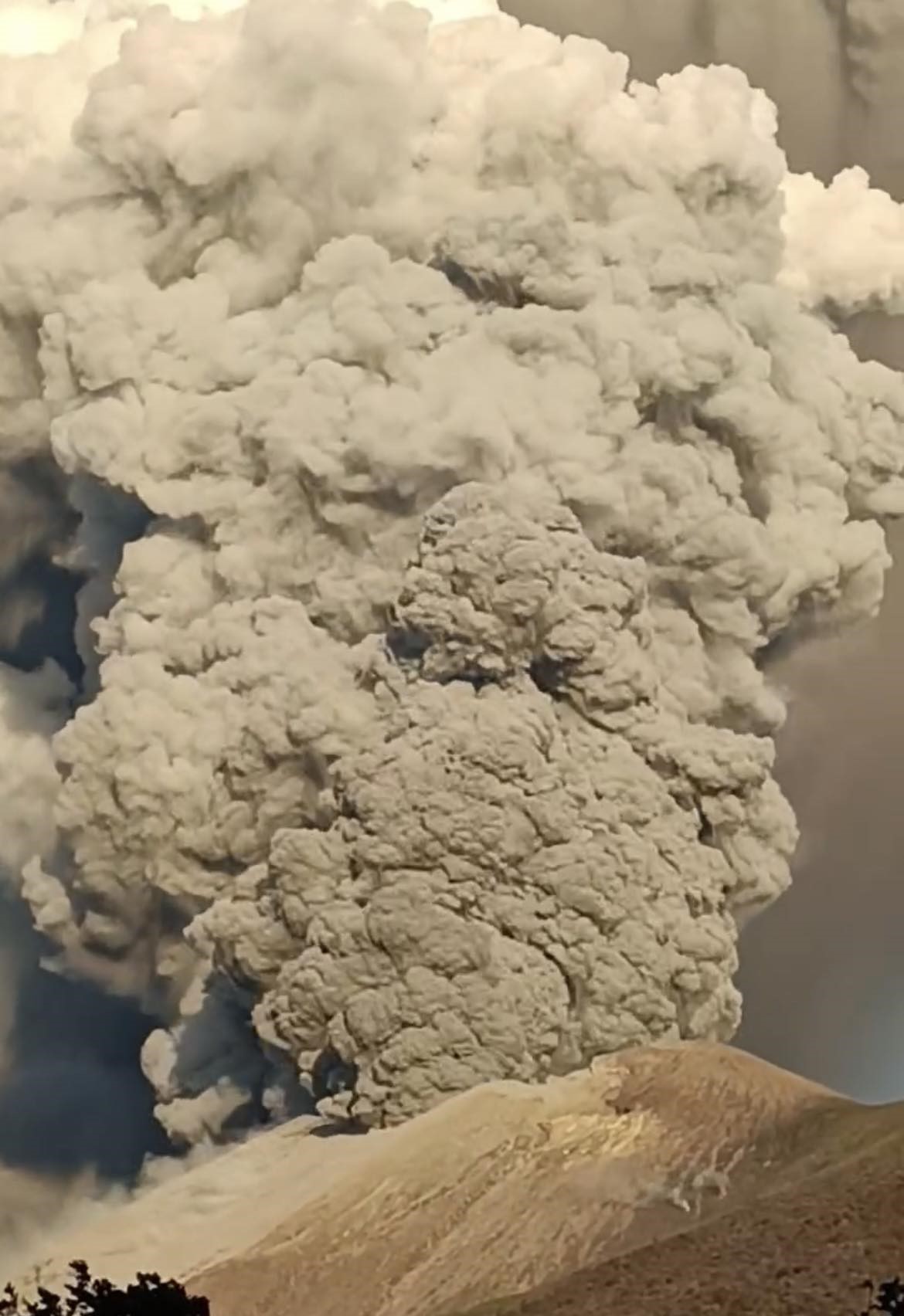
A moderately explosive eruption occurred at the summit crater of Kanlaon Volcano at 05:51 AM today, 8 April 2025, that lasted fifty-six (56) minutes based on seismic and visual recordings. The eruption generated a gray voluminous plume that slowly rose to 4,000 meters above the vent before bending and drifting west and southwest. Audible rumbling sounds of the eruption were reported in Brgys. Biak-na-Bato and Sag-ang, La Castellana, Negros Occidental and Brgy. Pula, Canlaon City, Negros Oriental. Pyroclastic density currents or PDCs descended the southern slopes within a kilometer of the crater, in the jurisdiction of La Castellana, based on visual and thermal camera monitoring. Large ballistic fragments were also observed to have been thrown around the crater within a few hundred meters and caused burning of vegetation near the volcano summit. Thin ashfall has been reported in the following localities of Negros Occidental: La Carlota City– Brgys. Roberto Salas Benedicto, La Granja, Haguimit, Nagasi, Yubo, Ara-al, San Miguel and Cubay; Bago City– Brgys. Mailum, Ilijan, and Binubuhan, and; La Castellana– Brgys. Sag-ang and Mansalanao. Sulfurous fumes were also experienced strongly in Brgy. Cubay, La Carlota City and faintly as far as the Municipality of Hinigaran, Negros Occidental.
Monitoring Data Prior to the Eruption:
The eruption was preceded by short-term inflation or swelling of the southeastern edifice that began in 10 January 2025 and by a decline in average sulfur dioxide or SO2 emission from 4,014 tonnes/day since 3 June 2024 to 2,453 tonnes/day since 1 March 2025. SO2 emission yesterday averaged only 1,655 tonnes/day. There was no significant change in the average occurrence of volcanic earthquakes of 14 events/day since 3 June 2024. These parameters indicate that the blockage of volcanic gas emission (or closed-system degassing) and resulting pressurization and swelling of the edifice drive moderately explosive eruption at Kanlaon.
Current Outlook:
No pronounced increases in volcanic earthquake, ground deformation or volcanic gas parameters have followed the eruption as of present. Alert Level 3 (magmatic unrest) therefore remains over Kanlaon Volcano. This means that this morning’s explosive eruption may be followed by similar short-lived explosive eruptions in the short term or even progress to lava eruptions that generate lava flows and lava fountaining activity.
Recommendations:
It is recommended that communities within a 6-km radius of the summit crater remain evacuated due to the danger of potential pyroclastic density currents or PDCs, ballistic projectiles, rockfalls, ashfall and other related hazards that could be posed by similar explosive eruptions. Local government units must also prepare their communities within the PDC hazard zone for subsequent evacuation in case unrest further escalates and hazardous worst-case explosive eruption becomes imminent. Increased vigilance must be exercised should intense rains occur since loose ash or pyroclastic material have been deposited in the upper slopes and could easily be eroded to generate lahars and sediment-laden streamflows in channels draining the southern and western portions of the edifice. Civil aviation authorities must also advise pilots to avoid flying close to the volcano’s summit as ash from any sudden eruption can be hazardous to aircraft.
DOST-PHIVOLCS maintains close monitoring of Kanlaon Volcano and any new development will be communicated to all concerned stakeholders.
Source : DOST-PHIVOLCS
Photo : Civil Defense PH.
Iceland , Reyjanes Peninsula :
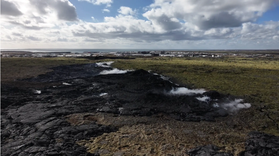
Uplift continues beneath Svartsengi . The dike intrusion on April 1 is the largest since November 2023
Updated April 8, at 16:15 UTC
Ongoing microseismic activity near the dike, but gradually decreasing
Clear evidence of continued uplift beneath Svartsengi
Uplift is currently occurring at a faster rate than after previous eruptions
Too early to determine how magma accumulation rates will evolve
Approximately 30 million cubic meters of magma left the magma chamber on April 1, making this the largest magma intrusion since November 10, 2023
Hazard assessment has been updated and is valid until April 15, if conditions remain unchanged
As long as magma continues to accumulate beneath Svartsengi, further intrusions and even eruptions remain likely
Deformation measurements clearly show that uplift beneath Svartsengi is ongoing. The current uplift rate is faster than that observed following previous eruptions. This may be explained by the large volume of magma — around 30 million cubic meters — that was released from the system during the most recent event.
However, it is still too early to predict how the rate of magma accumulation will develop. Past events have shown that accumulation rates typically decline as more time passes between eruptions. At least a week, and possibly several weeks, will need to pass before we can evaluate if — and how — the rate of accumulation will change.
Based on the data currently available, magma continues to flow into the Svartsengi system, indicating that the volcanic activity in the Sundhnúkur crater row area is not over. As long as this accumulation continues, repeated intrusions — and potentially eruptions — remain likely. The Icelandic Meteorological Office continues to monitor the area closely and assess possible scenarios based on the latest data.
Microseismic activity continues to be measured along the northern part of the April 1 dike. Additionally, triggered earthquakes are still being detected near Reykjanestá and west of Kleifarvatn. While deformation has decreased around the northern part of the dike, deformation continues to be detected near the dike itself on GPS stations and satellite imagery.
Source : IMO
Photo : RÚV – Víðir Hólm Ólafsson Capture d’écran , 5 Avril 2025 .