March 07 , 2025.
Hawaii , Kilauea :
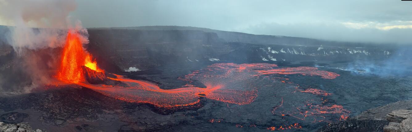
Lava flows from episode 12 covered approximately two-thirds of Halemaʻumaʻu. The center the episode 12 flow remained active overnight with ooze outs and small crustal overturns. See the March 5 Kīlauea update for a detailed account of the episode 13 eruption. Lava flows unrelated to the episode 12 eruption continue to spread out on the downdropped block on the eastern side of Halemaʻumaʻu. These appear to be fed from by older stored lava from beneath the crater floor.
Summit tilt changed rapidly from inflationary to deflationary at the onset of the episode and was measured at 11 microradians of deflationary tilt during the eruption. Tilt turned back to inflationary 10:37 a.m. on March 5 with the end of eruptive activity and continued through the past day recovering 3.5 microradians. No seismicity was recorded with Kīlauea’s summit over the past day and volcanic tremor decreased significantly with the end episode 12. On March 4, weather and daylight conditions allowed for an approximate measurement of 20,000-35,000 tonnes/day of SO2 emissions while both fountains were at their maximum. Rates have dropped over since that time and were measured at 1,800 tonnes/day yesterday afternoon, after the end of eruptive activity.
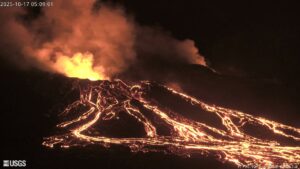
During the early evening of March 4, 2025, USGS scientists captured this view of both the north and south vent erupting lava fountains during episode 12 of the ongoing Kīlauea summit eruption. During this episode, lava fountains reached up to 250-300 feet (80-90 meters) in height.
Episodes of Halemaʻumaʻu lava fountaining since December 23, 2024, have continued for 13 hours to 8 days and episodes have been separated by pauses in eruptive activity lasting from less than 24 hours to 12 days. While episode 12 began with intermittent eruption at 7:30 a.m. HST, continuous eruption did not begin until 12:45 p.m. HST and lasted for just under 22 hours.
Source : HVO
Photo : USGS / M. Patrick
Philippines , Kanlaon :
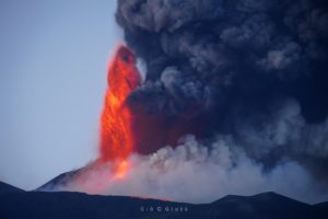
The Philippine Institute of Volcanology and Seismology (PHIVOLCS) reported continuing eruptive activity at Kanlaon during 25 February-3 March. The seismic network recorded 3-10 daily volcanic earthquakes, though on 28 February there were 24 volcanic earthquakes along with three periods of volcanic tremor lasting from three minutes to two hours and 13 minutes. Average daily sulfur dioxide emissions ranged from 1,118 to 2,527 tonnes per day. Gas-and-steam emissions that were sometimes diffuse rose generally as high as 100 m above the summit and drifted W, SW, and SSW; weather conditions obscured views during 2-3 March.
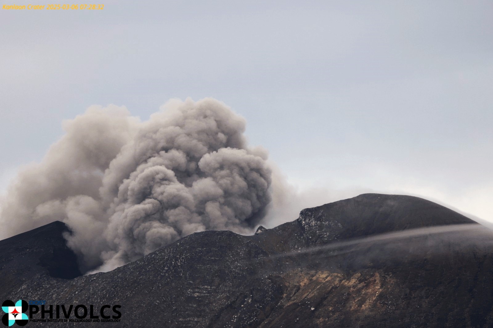
On 28 February three periods of ash emissions corresponding to the periods of volcanic tremor produced gas-and-ash plumes that rose as high as 150 m above the summit and drifted SW and WSW. According to the Office of Civil Defense and news reports more than 8,500 people remained in evacuation shelters, noting that 36 families from La Castellana (16 km SW) and 48 families from Canlaon City (10 km ESE) will not be able to return to their homes within the 4-km permanent danger zone. The Alert Level remained at 3 (on a scale of 0-5); the public was warned to stay 6 km away from the summit and pilots were warned not to fly close to the volcano.
Sources: Philippine Institute of Volcanology and Seismology (PHIVOLCS), Office of Civil Defense, Inquirer.net, GVP.
Photo : Phivolcs
Colombia , Chiles / Cerro Negro :
San Juan de Pasto, March 4, 2025, 4:30 p.m. .
Following the monitoring of the activity of the Chiles/Cerro Negro volcanoes, the Colombian Geological Survey (SGC), an entity attached to the Ministry of Mines and Energy, reports that:
In the period from February 25 to March 3, 2025, and after the increase recorded in mid-February 2025, seismic activity continues to show fluctuations, with a decreasing trend.
Compared to the previous period, the most notable changes have been:
• Decrease in seismic occurrence and energy released; processes associated with rock fracture inside the volcano predominate. A record is kept of events associated with fluid dynamics, some of them with very low frequency content.
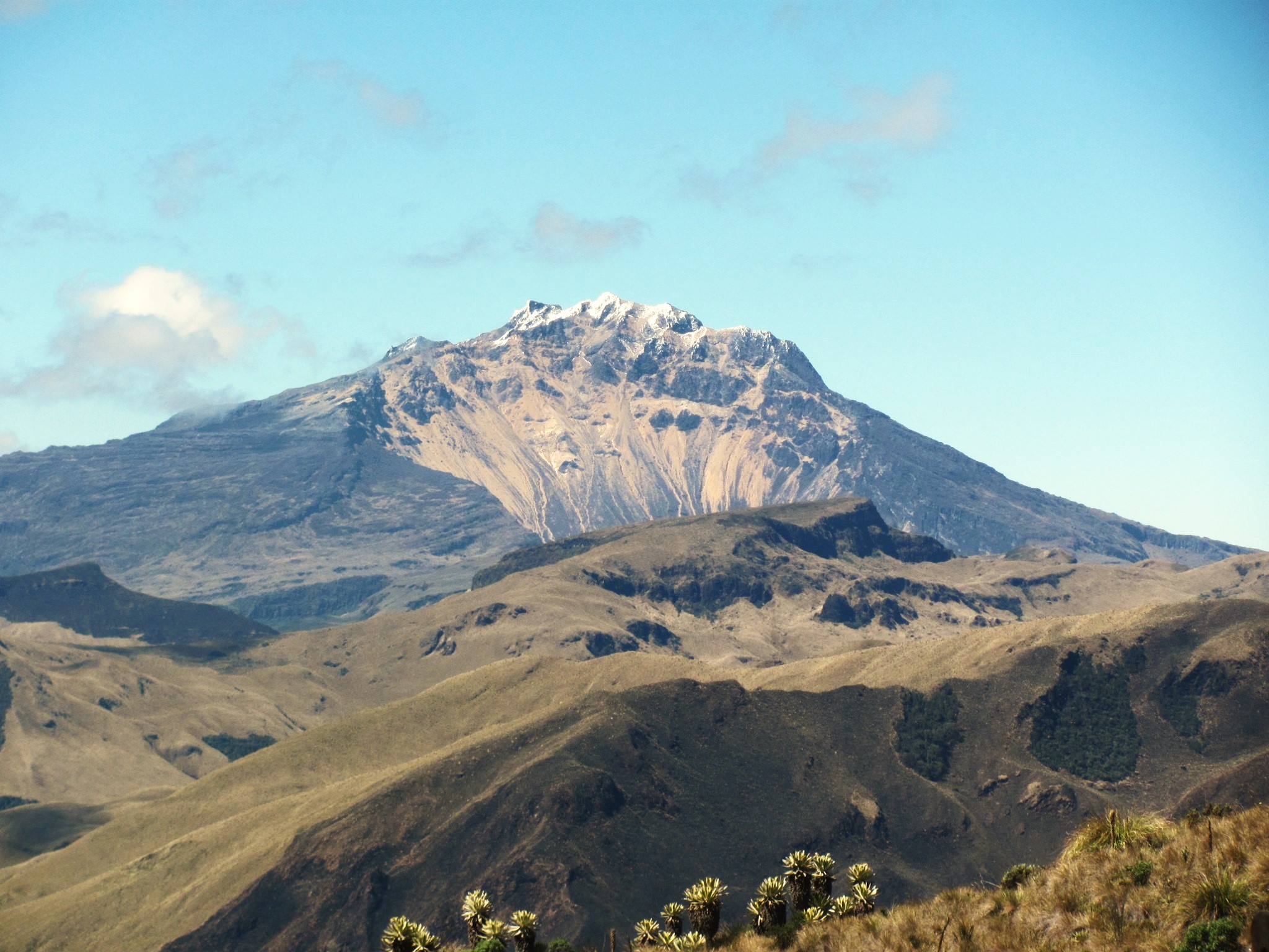
• Earthquakes associated with both rock fracture and fluid movement have been located, as well as those involving both processes. The events have been located mainly in the so-called Chiles Volcano Collapse Zone, between the highest part of the volcano to about 2 km to the north, at a depth of between 2 and 5 km from the summit of the volcano (4700 m above sea level) and a maximum magnitude of 1.0. Other earthquakes have been located scattered in the Chiles Volcano area, at distances of up to 4 km and at depths of less than 10 km, from the summit of the volcano, with a maximum magnitude of 1.3.
• Instruments that record crustal deformation and satellite remote sensing continue to show changes associated with an inflationary process in this volcanic area.
Based on the above, the SGC recommends closely monitoring its evolution through weekly bulletins and other information published through our official channels, as well as instructions from local and departmental authorities and the National Disaster Risk Management Unit (UNGRD).
Volcanic activity remains in yellow alert status: active volcano with changes in the behavior of the base level of monitored parameters and other manifestations.
Source et photo : SGC
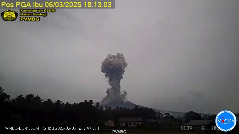
Indonesia , Ibu :
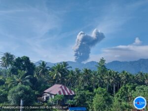
An eruption of Mount Ibu occurred on Thursday, 6 March 2025, at 18:09 WIT with an observed ash column height of ±1500 m above the peak (±2825 m above sea level). The ash column was observed to be grey in colour with a thick intensity, oriented towards the West. This eruption was recorded on a seismograph with a maximum amplitude of 28 mm and a duration of 167 seconds.
VOLCANO OBSERVATORY NOTICE FOR AVIATION – VONA
Issued : March 06 , 2025
Volcano : Ibu (268030)
Current Aviation Colour Code : ORANGE
Previous Aviation Colour Code : orange
Source : Ibu Volcano Observatory
Notice Number : 2025IBU481
Volcano Location : N 01 deg 29 min 17 sec E 127 deg 37 min 48 sec
Area : North Maluku, Indonesia
Summit Elevation : 4240 FT (1325 M)
Volcanic Activity Summary :
Eruption with volcanic ash cloud at 09h09 UTC (18h09 local).
Volcanic Cloud Height :
Best estimate of ash-cloud top is around 9040 FT (2825 M) above sea level or 4800 FT (1500 M) above summit. May be higher than what can be observed clearly. Source of height data: ground observer.
Other Volcanic Cloud Information :
Ash cloud moving to west. Volcanic ash is observed to be gray. The intensity of volcanic ash is observed to be thick.
Remarks :
Eruption recorded on seismogram with maximum amplitude 28 mm and maximum duration 167 second.
Source et photo : Magma Indonésie.
Guatemala , Santiaguito :
Atmospheric conditions: Cloudy.
Wind: Northeast.
Precipitation: 5.0 mm.
Activity:
The observatory reports activity in the Caliente dome, with moderate to abundant degassing columns continuously dispersing in a southerly and southwesterly direction due to wind variability. 1 to 5 weak to moderate explosions per hour are recorded, accompanied by moderate block avalanches in the southerly and southwesterly directions, as well as accumulation of hot material mainly towards the southwest flank in the upper part of the lava flow. At night, intermittent incandescence can be observed during moderate avalanches and sustained incandescence at the beginning of the lava flow.
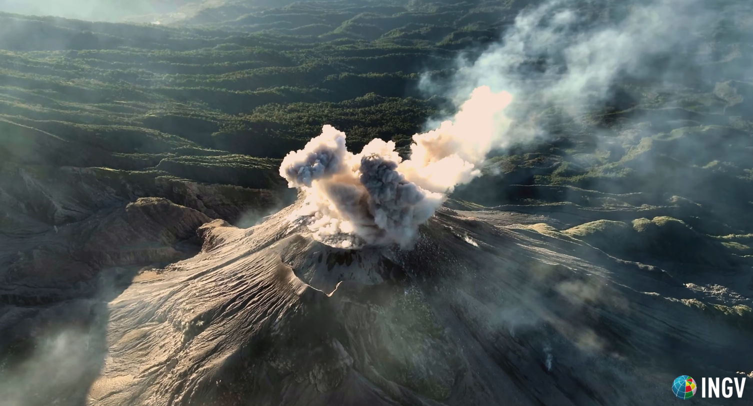
The accumulation of new material has caused an avalanche collapse in front of the lava flow. Moderate to strong explosions lift columns of gas and ash up to heights of 3,700 m (12,140 ft) and trigger short-distance pyroclastic flows extending along all flanks and weak and/or strong avalanches that can be audible several kilometres from the volcano. The occurrence of moderate to strong block and ash flows is not excluded, as well as possible long-distance pyroclastic flows in different directions, therefore the recommendations of special bulletin BESAN-002-2025 should be followed.
Source : Insivumeh
Photo : capture d’écran INGV Dr. Riccardo Civico ( 01/2025)