February 21 , 2025 .
Hawaii , Kilauea :
Thursday, February 20, 2025, 9:50 AM HST (Thursday, February 20, 2025, 19:50 UTC)
19°25’16 » N 155°17’13 » W,
Summit Elevation 4091 ft (1247 m)
Current Volcano Alert Level: WATCH
Current Aviation Color Code: ORANGE
Activity Summary:
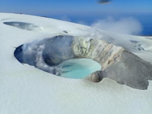
Episode 10 of the ongoing Halemaʻumaʻu eruption ended at 9:18 a.m HST on February 20 after just under 13 hours of fountaining.
The north vent stopped erupting at this time after gradually declining in height. Lava flows from this episode covered 75% of the floor of Halemaʻumaʻu within the southern part of Kaluapele (Kīlauea caldera).
Deflationary tilt at the summit recorded about 6.5 microradians during this episode. The end of the eruption was coincident with a rapid change from deflation to inflation at the summit and a decrease in seismic tremor intensity.
USGS Hawaiian Volcano Observatory (HVO) geologists captured this view of episode 10 of the Kīlauea summit eruption in Halema‘uma‘u during a sunrise field shift on February 20, 2025. HVO scientists measured fountain heights of about 45-50 m (148-164 feet) on average with frequent pulses reaching 60-65 meters (197-213 feet). Episode 10 started the evening of February 19, 2025, around 8:22 p.m. HST, with fountain heights reaching 90-125 meters (295-410 feet). The fountains continued to wane or decrease in the following hours and ended at 9:18 a.m. on February 20, 2025. The duration of episode 10 was about 13 hours. The north vent was the only active vent during this episode.
Each episode of Halemaʻumaʻu lava fountaining since December 23, 2024, has continued for 13 hours to 8 days and episodes have been separated by pauses in eruptive activity lasting less than 24 hours to 12 days.
No changes have been detected in the East Rift Zone or Southwest Rift Zone. HVO continues to closely monitor Kīlauea and will issue an eruption update tomorrow morning unless there are significant changes before then.
Kīlauea Volcano Alert Level/Aviation Color Code remain at WATCH/ORANGE. All current and recent activity is within Hawaiʻi Volcanoes National Park.
Source : HVO
Photo : USGS / H. Winslow.
Alaska / Aleutian Islands , Atka :
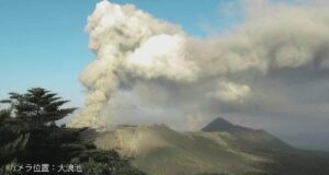
A single, small explosive event was detected in local seismic and infrasound data at 4:26 UTC (7:26 pm AKST) at the Atka volcanic complex. As a result, the Aviation Color Code and Alert Level has been changed to ORANGE/WATCH. The explosive event was short in duration (less than 10 seconds), and it is likely that a small amount of volcanic ash was erupted during this event. A meteorological cloud deck at an altitude of 8,000 to 10,000 ft above sea level obscured direct satellite observations, but no ash emissions were observed above the clouds. There have been no further explosive events observed and no noticeable change in seismic activity.
Local seismic and infrasound sensors and web cameras are used to monitor the Atka volcanic complex along with regional infrasound and lightning networks, and satellite data.
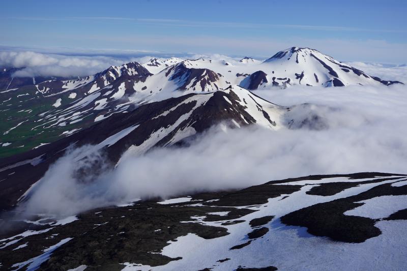
The Atka Volcanic Complex consists of a central shield and Pleistocene caldera and four notable volcanic cones. A major explosive dacitic eruption accompanied formation of the caldera about 500,000 to 300,000 years ago; approximately half of the caldera rime remains, open towards the NW. The Sarichef cone, ~5 km ESE of the caldera rim, retains a symmetrical profile, unlike most other heavily eroded features outside the caldera to the S and W. The Kliuchef stratovolcano grew within the caldera and exhibits five eruptive vents striking NE, including two at the summit, that have been active in the Holocene. A 700-m-diameter crater 1 km NE of the summit may have been the source vent for a large 1812 CE eruption. Hot springs and fumaroles are located on the flanks of Kliuchef and in a glacial valley to the SW. The most frequently active volcano of the complex is Korovin, at the NE tip of Atka Island about 5 km N of Kliuchef. An 800-m-diameter crater on the SE side of the summit contains a deep circular pit that sometimes contains a crater lake thought to be the source of phreatic ash explosions. The smaller Konia cone, slightly offset to the E, lies between Kliuchef and Korovin. Most of the lava flows in the complex are basaltic, though some dacitic flows are also present.
Source : AVO
Photo : Lopez, Taryn / Alaska Volcano Observatory / University of Alaska Fairbanks, Geophysical Institute ( 2019) , GVP.
Philippines , Mayon :
MAYON VOLCANO LAHAR ADVISORY , 21 February 2025 , 12:00 PM
Based on the Philippine Atmospheric Geophysical and Astronomical Services Administration (PAGASA) Weather Advisory No. 10 issued at 11:00AM today, 21 February, 2025, a “shear line” weather system affecting Southern Luzon is predicted to cause continued potentially high-volume rainfall over Bicol Region. Heavy to intense rainfall is expected over the Albay Province in the coming days. This can generate volcanic sediment flows or lahars, muddy streamflows or muddy run-off in rivers and drainage areas on the monitored active volcano. DOST-PHIVOLCS thus strongly recommends increased vigilance and readiness of communities in pre-determined zones of lahar and related hazards on Mayon Volcano.
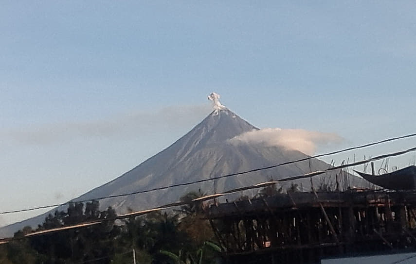
Prolonged and heavy rainfall may also generate post-eruption lahars on major channels draining Mayon Volcano by incorporating loose material from remnant PDC deposits from the January-March 2018 and June-December 2023 eruptions. The bulk of erodible PDC deposits occupy the watershed areas of the Mi-isi, Mabinit, Buyuan, Bonga and Basud Channels. In addition, older and erodible eruption deposits on the watershed areas of the eastern and western slopes of the edifice and can be remobilized as non-eruption lahars by erosion of banks and channel beds. Lahars can threaten communities downstream of the above channels with inundation, burial and wash away. Potential lahars and sediment-laden streamflows may occur along the Miisi, Binaan, Anoling, Quirangay, Maninila, Masarawag, Muladbucad, Nasisi, Mabinit, Matan-ag, Buyuan, Basud, and Bulawan Channels in Albay Province.
DOST-PHIVOLCS strongly advises the communities and local government units of the above identified areas of risk to continually monitor the weather conditions and take pre-emptive response measures for their safety from the on-going “shear line” weather system.
Source : DOST-PHIVOLCS
Photo : Manilla bulletin
Indonesia , Marapi :
INCREASED VOLCANIC EARTHQUAKES ON MARAPI, WEST SUMATERA, 19 FEBRUARY 2025 .
Mount Marapi is located in West Sumatra Province.
Mount Marapi frequently erupts. Eruptions have been explosive from the Verbeek crater. Eruptive activity is usually accompanied by rumbling sounds, with eruption products in the form of ash, lapilli, and sometimes also followed by the ejection of incandescent material and volcanic bombs.
The series of discontinuous eruptions/explosions continues to this day due to the dynamics of rising and falling fluid supply from deep within the body of Mount Marapi. Between early and mid-February 2025, there was an increase in earthquakes and volcanic tremors on Mount Marapi, which was linked to an increase in fluid supply from deep underground. As a result, there was an increase in emission and eruption activity to release the build-up of fluid pressure.
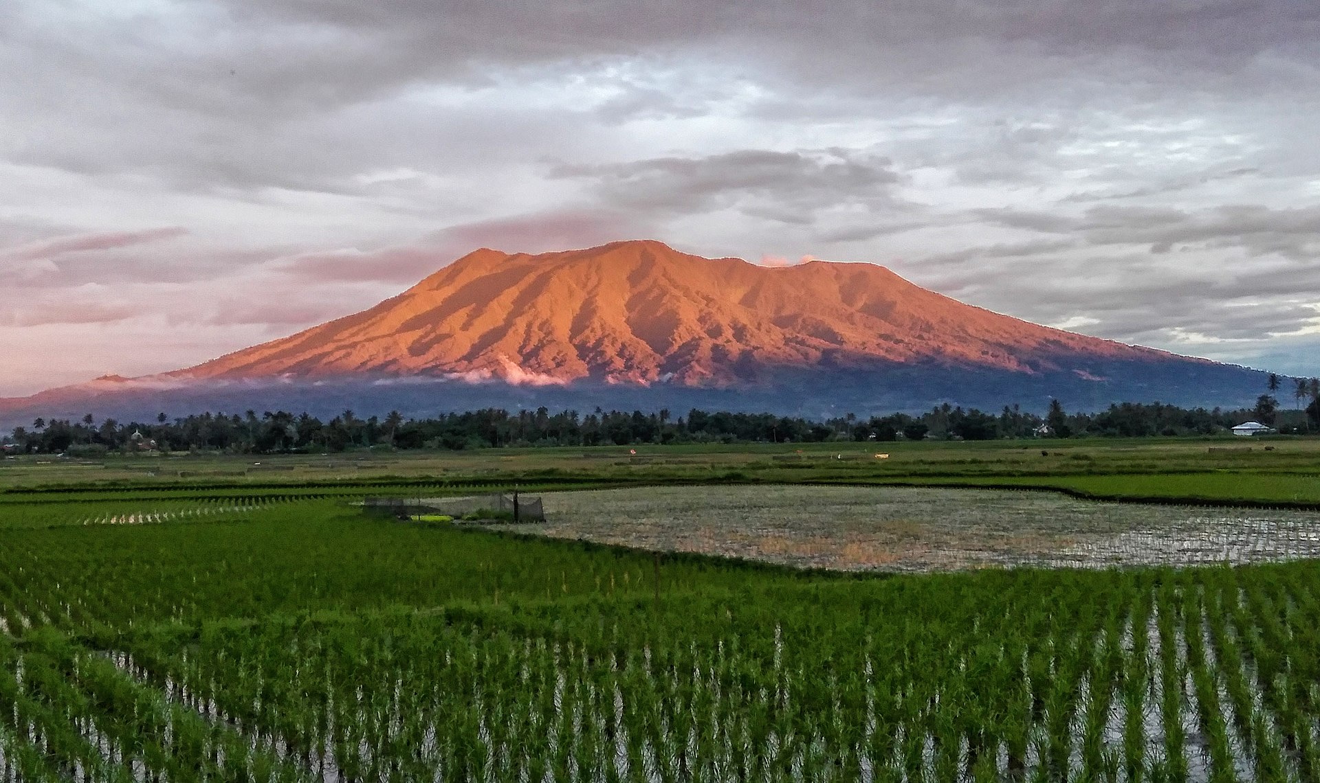
According to the latest monitoring data (visual and instrumental), it appears that the activity of Mount Marapi is still high. The seismic velocity variation and coherence data are still low, indicating that the stress on the volcanic body is still high and that the state of the environment near the surface of the volcano is not yet stable. Therefore, the risk of an eruption still exists, and it can occur at any time in the form of a release of accumulated pressure (energy) with a potential danger of ejection of eruption materials estimated still within a radius of 3 km from the activity center (Verbeek crater) of Mount Marapi.
Based on the analysis and evaluation of the comprehensive monitoring data, the activity level of Mount Marapi remains at level II (WASPADA).
Source : PVMBG
Photo : Dody.bukittinggi ( 2023)
Colombia , Galeras :
San Juan de Pasto, February 18, 2025, 3:40 p.m. .
Following the monitoring of the activity of the Galeras volcano, the Colombian Geological Survey (SGC), an entity attached to the Ministry of Mines and Energy, reports that:
Between February 11 and 17, 2025, volcanic activity remained at low levels, similar to those recorded in recent months. Compared to the previous week, the main variations in the monitored parameters were:
• An increase in the frequency of earthquakes was observed, with a slight decrease in the seismic energy released. The predominance of seismicity associated with rock fracture processes within the volcano continued.
• Most of the fracture earthquakes were located near the volcanic cone, at depths less than 2 km from the summit (4,200 m above sea level). Other events were located scattered in various sectors of the volcanic structure, at distances of up to 8 km and at depths of less than 10 km. The maximum magnitude for this type of earthquake was 0.5.
• Low-altitude white gas emissions, with variable dispersion depending on the wind direction, were observed, coming from the main crater and the fumarole fields of Las Chavas, to the west, and El Paisita, to the north of the active cone.
• The other parameters of the volcanic monitoring showed stability.
Based on the above, the SGC recommends closely monitoring the evolution through the weekly bulletins and other information published through our official channels, as well as the instructions of the local and departmental authorities and the National Disaster Risk Management Unit (UNGRD).
The volcanic activity remains in yellow alert status: active volcano with changes in the behavior of the base level of the monitored parameters and other manifestations.
Source et photo : SGC