February 03 , 2025 .
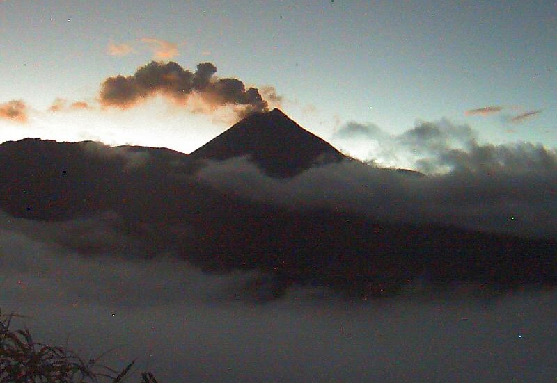
Greece , Santorini :
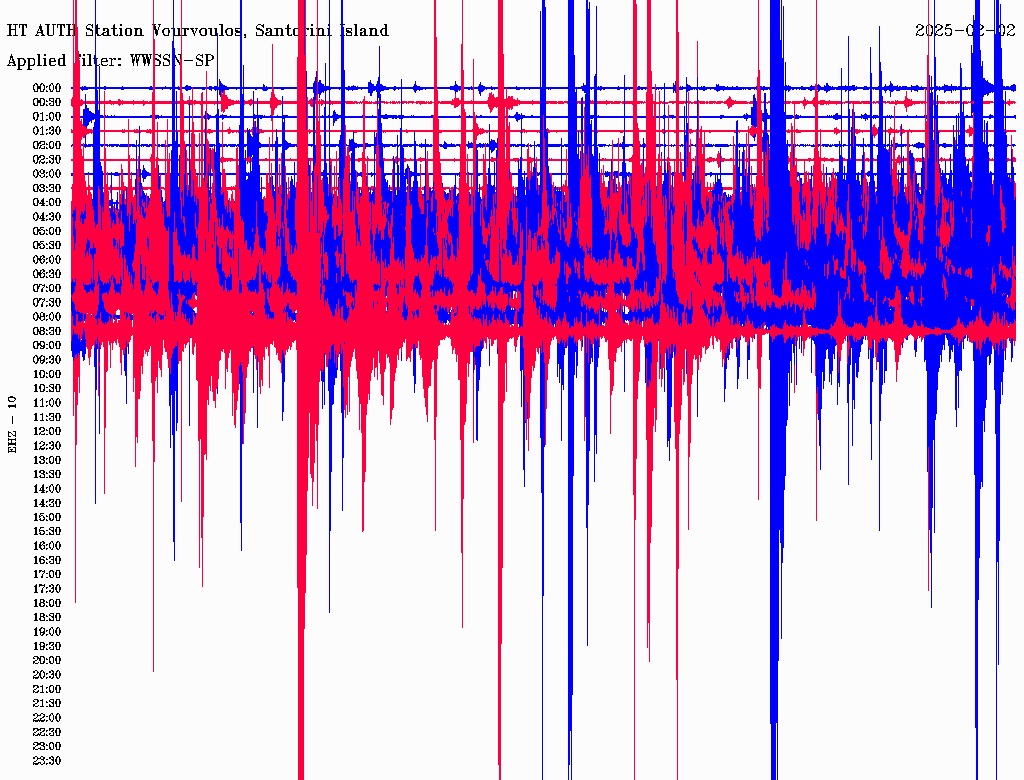
Earthquake swarm near Santorini intensifies Most intense earthquake: M 4.9.
Santorini residents are trying to leave the island by any means necessary. In addition to the long queues outside travel agencies, airline tickets are also selling out.
Due to high demand, only a few seats remain on tomorrow’s Aegean and Sky Express flights. One-way tickets average 200 euros.
Anxiety and fear prevail in Santorini following the successive seismic tremors in recent hours, with many residents choosing to spend the night outside their homes. Disturbed by the ongoing seismic activity, numerous Santorinians have sought temporary shelter in their cars, fearing the possibility of a stronger earthquake.
“We will not sleep in our homes tonight. The earth is constantly shaking, and we are afraid of what might happen,” a resident told Proto Thema. , describing the prevailing sense of concern. Others prefer to stay awake or sleep in open spaces for safety reasons.
Meanwhile, at a meeting held at the Maximos Mansion regarding the recent seismic activity in the sea area between Santorini and Amorgos, Minister of Civil Protection Vasilis Kikilias stated:
“All aspects of the seismic activity are being examined. The measures taken so far are strictly preventive. The committee for seismic risk management will remain active and meet continuously to provide updates. I urge our fellow citizens to follow the experts’ guidelines and comply with safety measures to manage the current situation effectively. There is vigilance, preventive measures, and organization in place. Since the committee consists of scientists, I sincerely request that everyone ensure accurate information is shared, giving people a clear understanding of the facts,” he said.
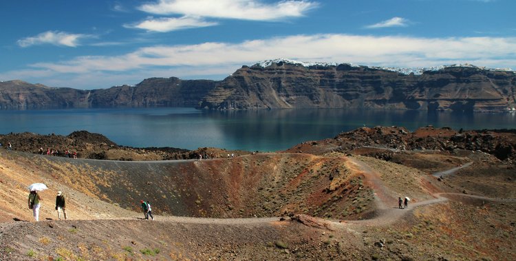
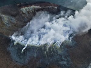
The Greek government is closely monitoring mild seismic and volcanic activity detected in the Santorini caldera, as officials convene to assess the situation and implement preventive measures.
Minister of Climate Crisis and Civil Protection Vassilis Kikilias chaired a high-level meeting on Wednesday to discuss the latest developments and strengthen civil protection efforts for the island, known for its unique geological characteristics and historical volcanic activity.
The meeting followed recommendations from the Permanent Scientific Committee for the Monitoring of the Greek Volcanic Arc, which has recorded increased activity in the central fault of Kameni, located in the northern part of the caldera. Scientists are closely analysing data and continuously updating precautionary plans to ensure preparedness.
According to a statement from the Ministry of Climate Crisis and Civil Protection, the current volcanic activity is comparable to that observed between 2011 and 2012. That period of heightened seismicity lasted approximately 14 months and concluded without a volcanic eruption.
Experts emphasise that, based on current data, there is no immediate cause for concern. However, continuous monitoring remains a priority to safeguard both residents and visitors to Santorini, one of Greece’s most popular tourist destinations.
Authorities reassure the public that all necessary precautions are being taken, and they remain in close coordination with scientific experts to address any potential developments.
Source et photo : Greekcitytimes . Com.
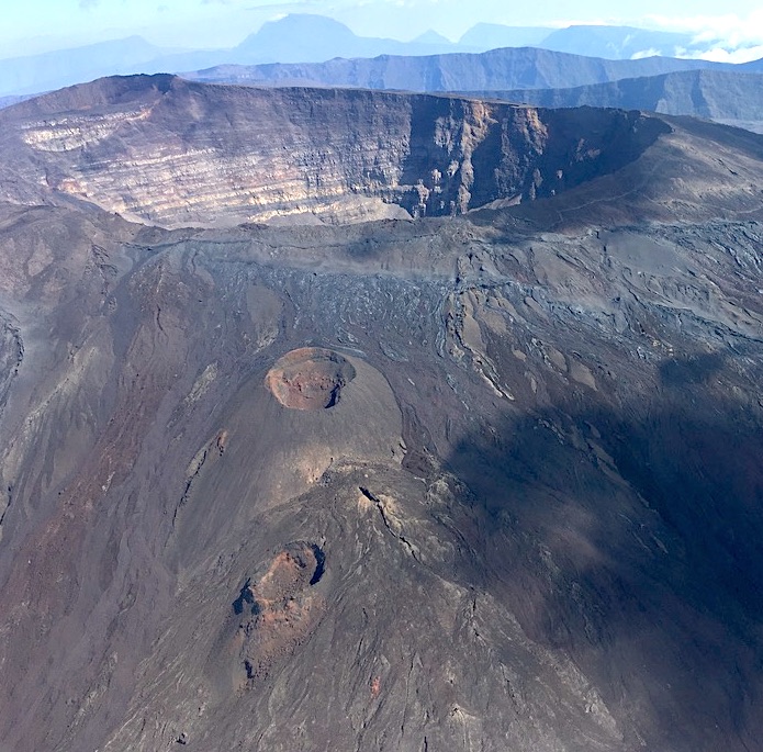
La Réunion Island , Piton de la Fournaise :
2024 Activity Report at Piton de la Fournaise
In 2024, no eruption occurred at Piton de la Fournaise.
However, following the last eruption – which took place from July 2 to August 10, 2023 – two periods of inflation of the edifice corresponding to a pressurization of the superficial magmatic reservoir (located around 1.5-2 km below the surface) were recorded in November 2023 and March 2024.
The second inflation phase in March 2024 was accompanied by an increase in seismicity under the summit craters with up to fifteen superficial volcano-tectonic earthquakes (0 to 2.5 km above sea level) per day.
The pressurization of the reservoir was not sufficient to trigger an intrusion of magma towards the surface. Since April 2024, seismic activity has remained low under the Piton de la Fournaise and a slight deflation of the structure has been recorded.
We have to go back to 2013 to know a year without an eruption. The last significant period of rest of the volcano without an eruption had lasted 1288 days between 10/12/2010 and 20/06/2014.
Rest periods are not rare in the recent history of Piton de la Fournaise, in fact volcanic activity is not continuous but presents major fluctuations on a decadal scale with eruptive cycles interspersed with several years without an eruption.
Thanks to the study of the ratios of Strontium (Sr) in lavas, Vlastélic et al., 2018 showed that these eruptive cycles were linked to the deep fusion zone. Each cycle thus corresponds to the emptying of the mantle material at a given location until there is no more fertile material. Thus, at the beginning of the cycle, the lavas have high 87Sr/86Sr ratios, indicating the fusion of fertile domains, while at the end of the cycle, the lavas have lower 87Sr/86Sr ratios, indicating the extraction of refractory matrix liquids. The decreases in Sr ratios during an eruptive cycle would reflect the exhaustion of fusible material (low melting point) in the source.
The study of the Sr ratios of the lavas emitted during the last eruption (July 2 – August 10, 2023) shows extremely low 87Sr/86Sr ratios (Vlastélic, personal communication), compatible with the hypothesis of an end of the eruptive cycle.
Source et photo : OVPF
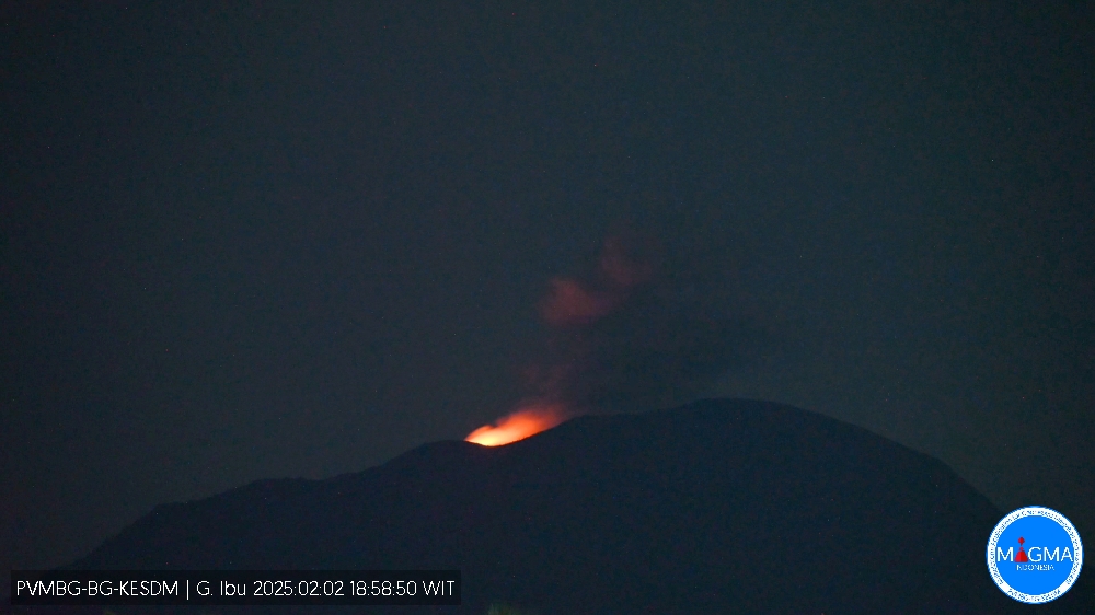
Indonesia , Ibu :
An eruption of Mount Ibu occurred on Monday, 3 February 2025, at 04:49 WIT with an observed ash column height of ± 600 m above the peak (± 1925 m above sea level). The ash column was observed to be grey in colour with a thick intensity, oriented towards the South-East. This eruption was recorded on a seismograph with a maximum amplitude of 28 mm and a duration of 66 seconds.
VOLCANO OBSERVATORY NOTICE FOR AVIATION – VONA
Issued : February 03 , 2025
Volcano : Ibu (268030)
Current Aviation Colour Code : ORANGE
Previous Aviation Colour Code : orange
Source : Ibu Volcano Observatory
Notice Number : 2025IBU246
Volcano Location : N 01 deg 29 min 17 sec E 127 deg 37 min 48 sec
Area : North Maluku, Indonesia
Summit Elevation : 4240 FT (1325 M)
Volcanic Activity Summary :
Eruption with volcanic ash cloud at 19h49 UTC (04h49 local).
Volcanic Cloud Height :
Best estimate of ash-cloud top is around 6160 FT (1925 M) above sea level or 1920 FT (600 M) above summit. May be higher than what can be observed clearly. Source of height data: ground observer.
Other Volcanic Cloud Information :
Ash cloud moving to southeast. Volcanic ash is observed to be gray. The intensity of volcanic ash is observed to be thick.
Remarks :
Eruption recorded on seismogram with maximum amplitude 28 mm and maximum duration 66 second.
Source et photo : Magma Indonésie .
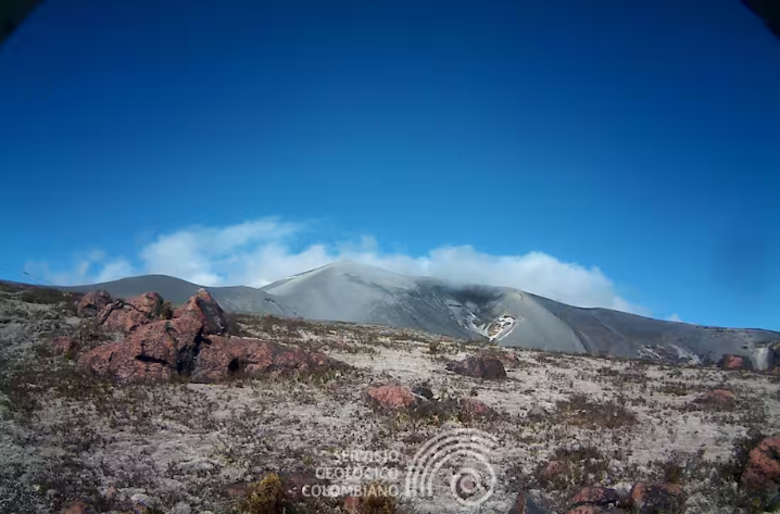
Colombia , Puracé – Puracé – Los Coconucos volcanic chain :
Popayán, February 2, 2025, 10:30 a.m. .
Following the monitoring of the activity in the Los Coconucos volcanic chain, the Colombian Geological Survey (SGC), an entity attached to the Ministry of Mines and Energy, reports that:
In the last few hours and until the time of publication of this bulletin, an increase has been recorded in seismic signals related to the movement of fluids, of the Tremor (TR) and Long Period (LP) type, which have been located under the crater of the Puracé volcano at depths of less than 2 km. The seismicity of the fracture is distinguished by an event that occurred on February 1 at 5:00 p.m., of magnitude 1.7, located 1.3 km deep under the crater of the Puracé volcano.
The deformation measurements do not show significant variations and the degassing levels reported in previous bulletins are maintained.
In Yellow Alert status, the volcano may present phenomena such as sporadic ash emissions (minor eruptions) whose magnitude and effects are limited and the dispersion of ash depends on the wind direction, presence of some incandescences, small explosions in the crater, low-energy thermal anomalies, noises, felt earthquakes, odors, precipitation of elemental sulfur near the crater and in hot springs and fumaroles, degassing in areas other than the crater, formation of fissures and appearance of minor lahars.
Based on the above, the SGC recommends closely monitoring the evolution through the extraordinary bulletins and other information published through our official channels, as well as the instructions of local and departmental authorities and the National Disaster Risk Management Unit (UNGRD).
The volcanic activity status remains at yellow alert: Active volcano with changes in the behavior of the base level of monitored parameters and other manifestations.
Source et photo : SGC
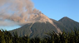
Ecuador , El Reventador .
DAILY REPORT ON THE STATE OF THE REVENTADOR VOLCANO , Sunday 02 February 2025.
Information Geophysical Institute – EPN.
Surface Activity Level: High , Surface Trend: No changes
Internal Activity Level: Moderate , Internal Trend: No changes
From 01 February 2025 , 11:00h to 02 February 2025 , 11:00h :
Seismicity:
The count of seismic events recorded at the station is detailed below.
Explosion (EXP) 78
Long Period (LP) 8
Emission Tremor (TREMI) 12
Harmonic Tremor (TRARM) 6
Rainfall / Lahars:
No rain has been recorded in the areas surrounding the volcano. **In case of heavy rains, these could remobilize the accumulated materials, generating mud and debris flows that would descend the flanks of the volcano and flow into adjacent rivers.
Emission / Ash Column:
Since yesterday, several emissions of gas and ash have been observed at heights between 300 and 700 meters above the crater in the West, Southwest and West-Northwest directions. In relation to this activity, the W-VAAC agency issued 1 report of an ash cloud at 1,010 meters above the crater level in a West-Southwest direction.
Other monitoring parameter:
In the last 24 hours, the MIROVA-MODIS satellite system recorded 1 moderate thermal anomaly and 1 weak thermal anomaly, while MIROVA VIIRS recorded 1 weak thermal anomaly.
Observation:
In the last 24 hours, several episodes of falling incandescent material up to 800 meters below the crater were observed, monitored by surveillance cameras. On the other hand, the volcano remained between clear and completely cloudy.
Alert level – SGR: Orange
Source : IGEPN
Photo : archive igepn