September 28 , 2024.
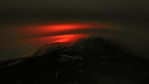
Chile , Copahue :
Special Report on Volcanic Activity (REAV), Biobío Region, Copahue Volcano. September 27, 2024, 11:30 a.m. local time (Continental Chile).
The National Geology and Mining Service of Chile (Sernageomin) publishes the following information, obtained through the monitoring equipment of the National Volcanic Monitoring Network (RNVV), processed and analyzed at the Southern Andean Volcanological Observatory (Ovdas):
In recent weeks, an increase in the activity of the Copahue volcano has been observed.
Specifically, aspects related to a possible disturbance of the surface hydrothermal system have been perceived, which has conditioned a greater height in the gas column coming from the El Agrio crater. Likewise, based on the analysis of satellite images, a reduction in the area and level of the acid lake housed inside the crater has been observed. Both of these aspects, increased visibility in the gas column and reduced crater lake conditions, suggest an increase in temperature within the volcanic system at surface level. Data that contribute to detecting deformations in the volcanic area are consistent with the aforementioned changes. Although seismicity has remained at low energy levels, monitoring of continuous tremor signals allows inferring an alteration of the system in recent days.
Taken together, the described aspects indicate a disturbed volcanic system that may evolve towards greater activity. Based on the history experienced by this volcano since the installation of a permanent monitoring network, sudden increases in the height of the gas column may occur with particle emissions, nocturnal incandescence, collapse of the crater lake and explosions that could impact the upper part of the volcano.
It is important to consider the probable impact zone within a radius of 500 m around the center of the crater, an observation that has been maintained in recent months given the characteristics of sudden increase with ejection of pyroclastic material to the surface.
The volcanic technical alert remains at: GREEN technical alert
Source : Sernageomin
Photo : Carpediem1971 ( 11/2020 )
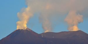
Alaska , Great Sitkin :
There have been no significant changes in the ongoing eruption at Great Sitkin Volcano this week. Satellite radar data through September 22 confirms that the slow eruption of lava in the summit crater continues. Intermittent small volcanic earthquakes persist and satellite images from occasional periods of clear viewing conditions show slightly elevated surface temperatures due to the active lava flow.
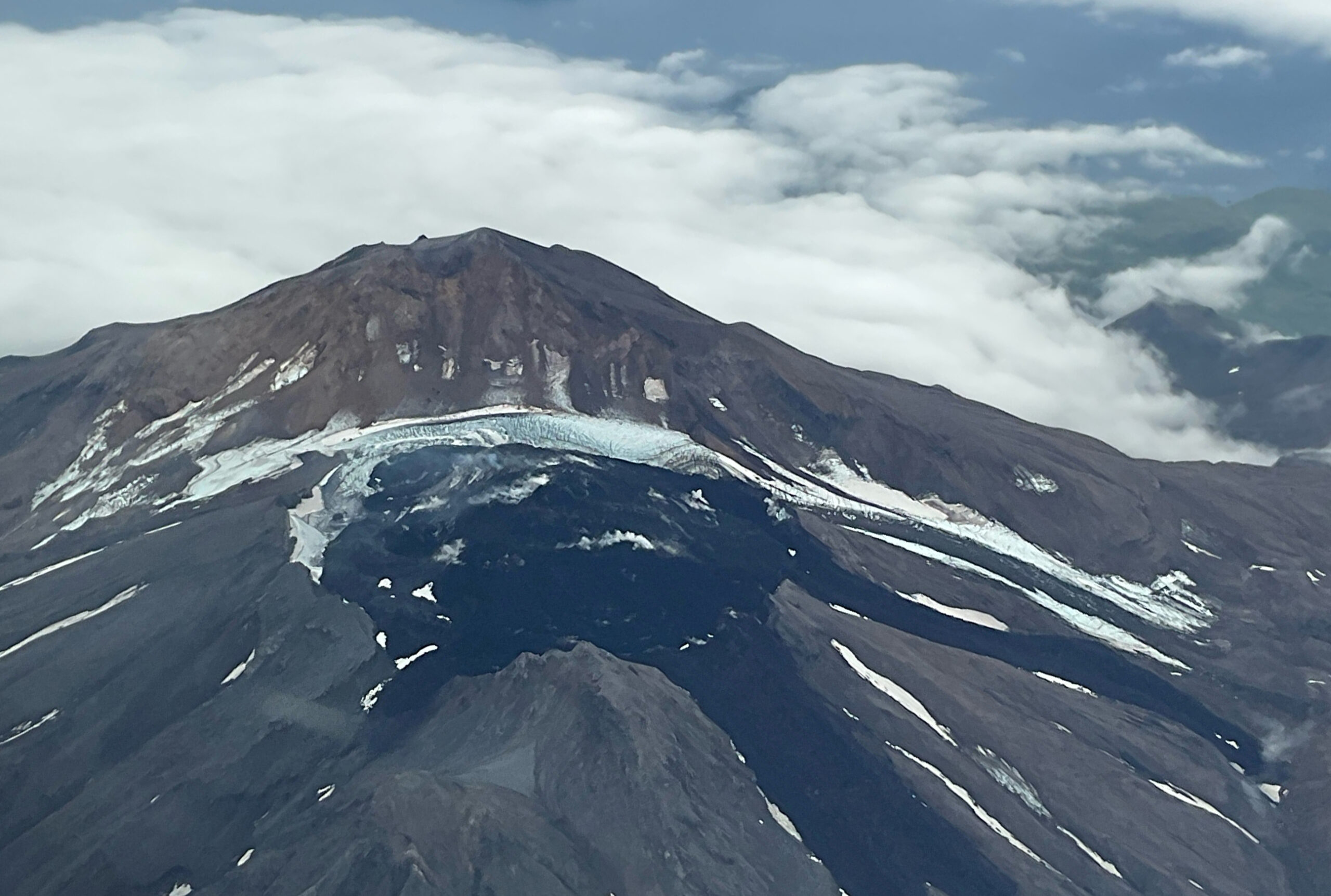
A close up view of the summit crater of Great Sitkin, taken from the air. The currently growing lava flow is steaming in places.
Since the single explosive event in May 2021, there have been no other explosions at Great Sitkin Volcano. The ongoing lava eruption began in July 2021, and the lava has filled most of the summit crater and advanced over the crater rim into valleys below. The Alaska Volcano Observatory (AVO) monitors Great Sitkin using seismic, infrasound, and satellite data.
Source : AVO
Photo : McConnell, Angela ( 11/09/2024)
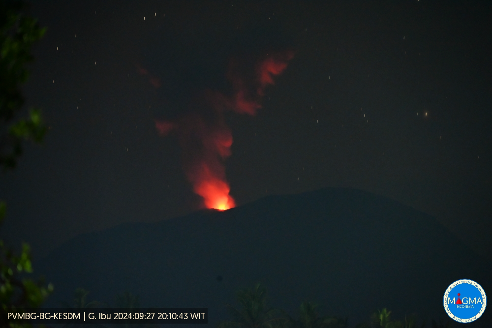
Indonesia , Ibu :
Ibu erupted on Friday, 27 September 2024 at 20:10 WIT with the height of the ash column observed at ± 700 m above the summit (± 2025 m above sea level). The ash column was observed to be grey with a thick intensity, oriented towards the northwest. This eruption was recorded on a seismograph with a maximum amplitude of 28 mm and a duration of 57 seconds.
VOLCANO OBSERVATORY NOTICE FOR AVIATION – VONA
Issued : September 27 , 2024
Volcano : Ibu (268030)
Current Aviation Colour Code : ORANGE
Previous Aviation Colour Code : orange
Source : Ibu Volcano Observatory
Notice Number : 2024IBU904
Volcano Location : N 01 deg 29 min 17 sec E 127 deg 37 min 48 sec
Area : North Maluku, Indonesia
Summit Elevation : 4240 FT (1325 M)
Volcanic Activity Summary :
Eruption with volcanic ash cloud at 11h10 UTC (20h10 local).
Volcanic Cloud Height :
Best estimate of ash-cloud top is around 6480 FT (2025 M) above sea level or 2240 FT (700 M) above summit. May be higher than what can be observed clearly. Source of height data: ground observer.
Other Volcanic Cloud Information :
Ash cloud moving to northwest. Volcanic ash is observed to be gray. The intensity of volcanic ash is observed to be thick.
Remarks :
Eruption recorded on seismogram with maximum amplitude 28 mm and maximum duration 57 second.
Source et photo : Magma Indonésie
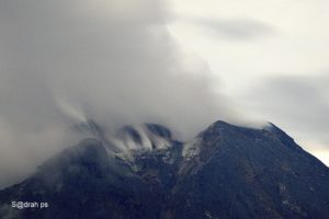
Colombia , Cerro Machin :
Manizales, September 24, 2024, 7:30 p.m.
From the monitoring of the activity of the Cerro Machín volcano, the Colombian Geological Survey (SGC), an entity attached to the Ministry of Mines and Energy, reports that:
During the week of September 17 to 23, 2024, the recording of seismicity associated with the fracturing of rocks inside the volcanic edifice continued. Compared to the previous week, the number of earthquakes recorded increased and the seismic energy released decreased. The earthquakes were located under the main dome and on the west, southwest, south and, to a lesser extent, southeast flanks of the volcanic structure, at distances of less than 3 km. The depths of the earthquakes varied between 2 km and 6 km from the summit of the volcano. The highest magnitude of the week was 1.5, corresponding to the earthquake recorded on September 23 at 11:26, located 1 km west-southwest of the main dome, at a depth of 3 km. September 17 and 18 saw the recording of the highest number of earthquakes of the week.
The other parameters measured and used for the diagnosis of volcanic activity have not presented significant changes during the period evaluated.
Based on the above, at the SGC we recommend to carefully monitor the evolution through the weekly bulletins and other information published through our official channels, as well as the instructions of the local and departmental authorities and the National Unit for Disaster Risk Management (UNGRD).
The alert status due to volcanic activity remains yellow: active volcano with changes in the behavior of the basic level of the monitored parameters and other manifestations.
Source et photo: SGC
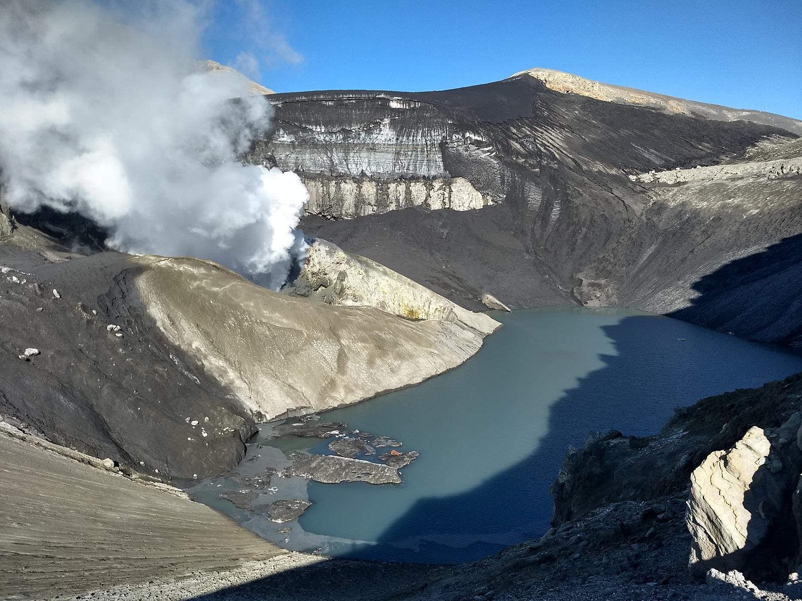
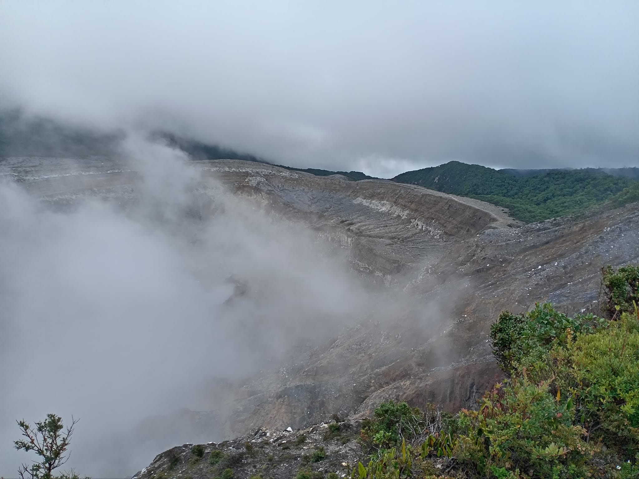
Costa Rica , Rincon de la Vieja / Poas :
Rincón de la Vieja Volcano
Latitude: 10.83°N;
Longitude: 85.34°W;
Altitude: 1916 m
Current activity level: Warning

This week, 12 expirations and one phreatic eruption were recorded. This activity is rich in water vapor, aerosols, and volcanic gases. None of these generated lahars or ash discharge. Background tremors have generally decreased compared to recent weeks. Sporadic low-magnitude volcano-tectonic earthquakes are recorded near the summit, associated with rock breakage.
The sporadic occurrence of long-period and « tornillo » type signals continues. The dominant frequency of tornillos continues the increasing trend compared to the last two weeks. When there is visibility, degassing of the crater is quite regular and constant. In recent weeks, a slight contraction and subsidence of the base of the volcanic edifice as well as a northward movement of the summit station have been detected. The MultiGas station recorded low gas concentrations this week. During the previous week, the NOVAC station detected a flow of 117 ± 55 t/d of SO2, lower than the previous week (117 ± 55 t/d of SO2). However, the weather conditions were not optimal for its measurement. The SO2 plume in the atmosphere has not been detected by the Sentinel-5P satellite since June 29.
Poas Volcano
Latitude: 10.20°N;
Longitude: 84.23°W;
Altitude: 2687 m
Current activity level: Warning
Seismic tremor remains of moderate amplitude. Almost no acoustic tremor is recorded. Low-frequency, low-amplitude LP-type seismic events are recorded. Occasional short tremors preceded by low-frequency signals are observed during this week. A slight contraction and subsidence of the northern crater is observed. The Multigas station detected low gas concentrations with a SO2/CO2 ratio close to 1.6 and a H2S/SO2 ratio close to 0.2. The NOVAC station recorded a flow rate of 308 ± 208 t/d of SO2, higher than the previous week (242 ± 177 t/d). However, the weather conditions were not optimal for the measurement. The last detection of the SO2 plume in the atmosphere by the Sentinel-5P satellite dates back to September 7. The lake level continues to rise, during the week it increased by about 0.6 m. The nighttime glow caused by the combustion of elemental sulfur ended this week.
Source : Ovsicori
Photos : Peninsulanicoya , excursiones adriel 02/08/2024