September 23 , 2024.
Indonesia , Ibu :
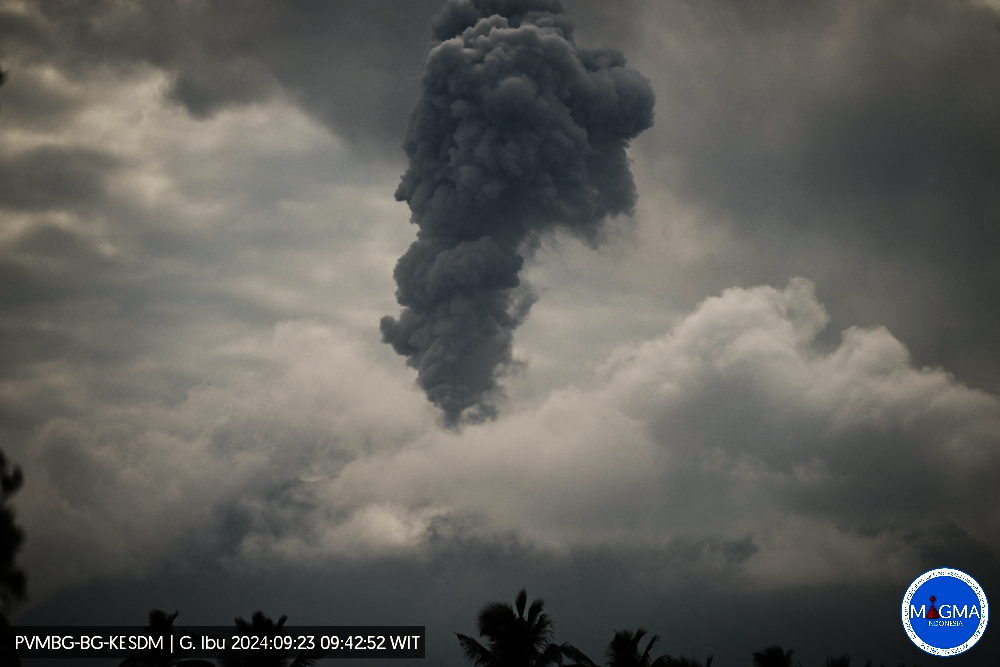
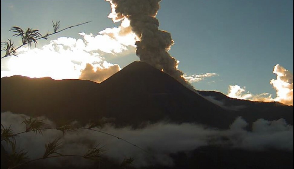
Mount Ibu erupted on Monday, 23 September 2024 at 20:07 WIT with the height of the ash column observed at ± 800 m above the summit (± 2,125 m above sea level). The ash column was grey in colour with a moderate to thick intensity, oriented towards the West. This eruption was recorded on a seismograph with a maximum amplitude of 28 mm and a duration of 78 seconds.
VOLCANO OBSERVATORY NOTICE FOR AVIATION – VONA
Issued : September 23 , 2024
Volcano : Ibu (268030)
Current Aviation Colour Code : ORANGE
Previous Aviation Colour Code : orange
Source : Ibu Volcano Observatory
Notice Number : 2024IBU843
Volcano Location : N 01 deg 29 min 17 sec E 127 deg 37 min 48 sec
Area : North Maluku, Indonesia
Summit Elevation : 4240 FT (1325 M)
Volcanic Activity Summary :
Eruption with volcanic ash cloud at 20h07 UTC (05h07 local).
Volcanic Cloud Height :
Best estimate of ash-cloud top is around 6800 FT (2125 M) above sea level or 2560 FT (800 M) above summit. May be higher than what can be observed clearly. Source of height data: ground observer.
Other Volcanic Cloud Information :
Ash cloud moving to southwest. Volcanic ash is observed to be gray. The intensity of volcanic ash is observed to be thick.
Remarks :
Eruption recorded on seismogram with maximum amplitude 28 mm and maximum duration 78 second.
Source et photo : Magma Indonésie.
Ecuador , El Reventador :
DAILY STATUS REPORT OF THE REVENTADOR VOLCANO , Sunday, September 22, 2024.
Information Geophysical Institute – EPN.
Surface Activity Level: High , Surface Trend: No Change
Internal Activity Level: Moderate , Internal Trend: No Change
From September 21, 2024, 11:00 a.m. to September 22, 2024, 11:00 a.m.:
Seismicity:
The count of seismic events recorded at the station is detailed below.
Explosion (EXP) 70
Long Period (LP) 18
Emission Tremor (TREMI) 11
Harmonic Tremor (TRARM) 3
Rainfall / Lahars:
Rainfall has been recorded in the volcano area without generating mud or debris flows. **In the event of heavy rains, these could remobilize the accumulated materials, generating mud and debris flows that would descend the sides of the volcano and flow into adjacent rivers.
Emissions / Ash Column:
Since yesterday afternoon, using satellite images, an emission of gas and ash has been observed, in a West-Northwest direction, at a height of 1,100 meters above the crater level. In addition, the Washington-VAAC agency has published five emission reports indicating heights of 1,100 to 1,300 meters above the crater level, in a West and Northwest direction.
Observation:
Until the date of this report, external reports indicate that the volcano has remained cloudy.
Alert level: Orange
Source et Photo : IGEPN ( 2022)
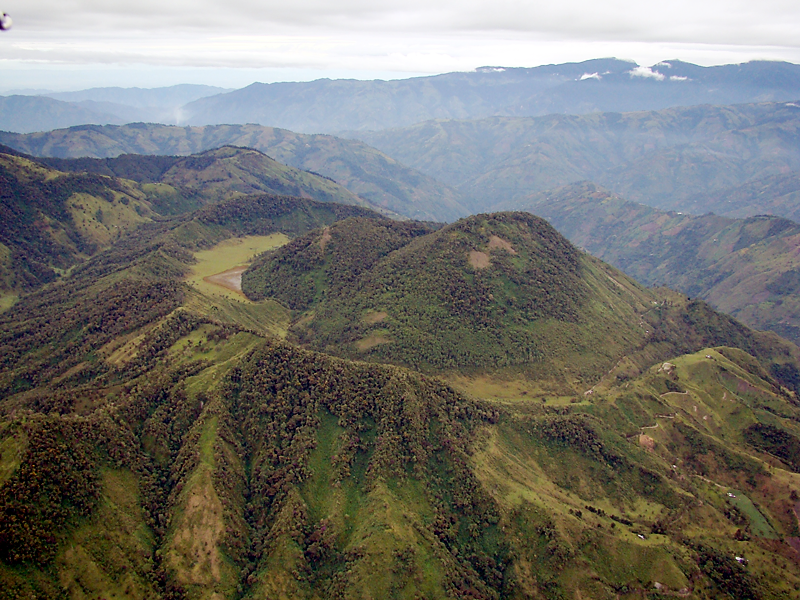
Colombia , Cerro Machin :
Manizales, September 17, 2024, 7:00 p.m.
From the monitoring of the activity of the Cerro Machín volcano, the Colombian Geological Survey (SGC), an entity attached to the Ministry of Mines and Energy, reports that:
For the week of September 10 to 16, 2024, the recording of seismicity associated with the fracturing of rocks inside the volcanic edifice continued. Compared to the previous week, this activity increased in the number of earthquakes recorded and in the seismic energy released. The earthquakes were mainly located to the west of the main dome, at distances of less than 3 km, and to a lesser extent, to the southwest and south of the volcanic structure.
The depths of the earthquakes varied between 1 km and 8 km from the summit of the volcano. The highest magnitude of the week was 2.2, corresponding to the earthquake recorded on September 13 at 10:08, during a seismic increase. This earthquake was located
about less than 1 km west of the main dome, at a depth of 4 km. September 13 stands out as the day with the highest number of earthquakes and the maximum magnitude of the week.
The other parameters measured and used for the diagnosis of volcanic activity did not show significant changes during the period evaluated.
Based on the above, the SGC recommends closely monitoring the evolution through the weekly bulletins and other information published through our official channels, as well as the instructions of local and departmental authorities and the National Disaster Risk Management Unit (UNGRD).
The alert status due to volcanic activity remains Yellow: active volcano with changes in the behavior of the base level of monitored parameters and other manifestations.
Source et photo ( 2018) : SGC.
Hawaii , Kilauea :
Sunday, September 22, 2024, 9:34 AM HST (Sunday, September 22, 2024, 19:34 UTC)
19°25’16 » N 155°17’13 » W,
Summit Elevation 4091 ft (1247 m)
Current Volcano Alert Level: WATCH
Current Aviation Color Code: ORANGE
Activity Summary:
The current eruption of Kīlauea volcano remains paused since the morning of September 20. Minor glow from the vent and small spots on the flows were visible yesterday evening, but mostly disappeared by early morning. Degassing from the vent continues with the gas plume moving to the southwest this morning. The eruption site is within a closed and remote area of Hawaiʻi Volcanoes National Park. There is no immediate threat to life or infrastructure. Residents of nearby subdivisions may experience volcanic gas emissions related to this activity which may increase and decrease over the coming hours and days. The Volcano Alert Level/Aviation Color Code remains at WATCH/ORANGE. No changes have been detected in the lower East Rift Zone or Southwest Rift Zone.
Summit Observations:
Eight small, shallow earthquakes were detected beneath the Kīlauea summit region over the past 24 hours. The tiltmeter at Uēkahuna remains flat, showing no deflation. The summit tiltmeter at Sandhill continues to record deflation, but at a significantly decreased rate compared to the onset of the eruption on September 16. This pattern suggests that only the deeper, southern summit magma body is continuing to supply magma at a decreased rate to the middle East Rift Zone. The most recent measurement of SO2 emission rate at the summit was 60 tonnes per day on September 17, 2024.
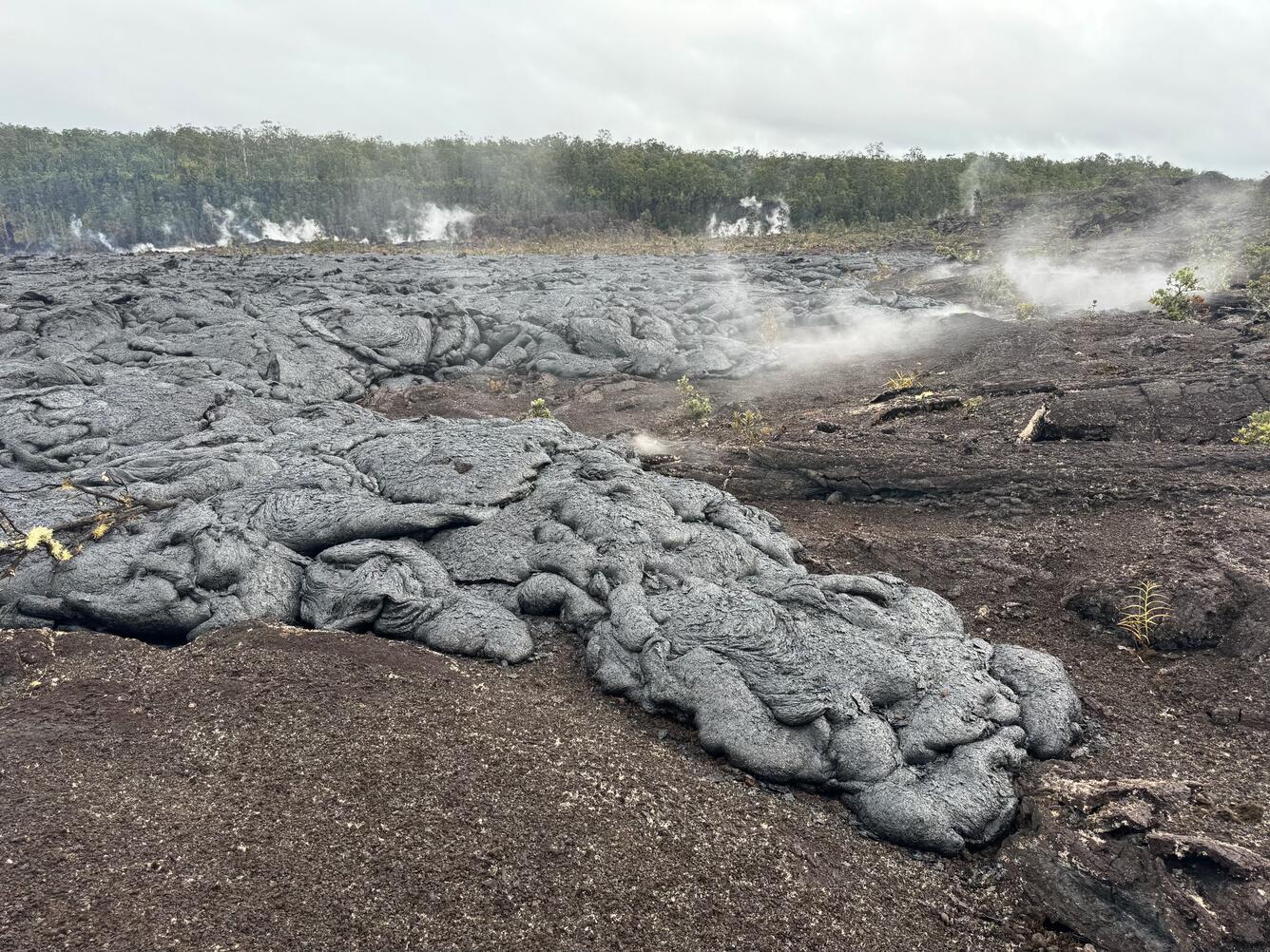
Pāhoehoe lava flows paved the floor of Nāpau Crater during the recent eruption on Kīlauea middle East Rift Zone. Pāhoehoe is characterized by smooth, billowy, and ropy surface textures. Recent lava flowed over tephra that previously coated this area of the crater floor. Tephra is a word for cinders and other volcanic products that travel through the air before being deposited on the ground surface. The vegetated areas outside of the crater, above the crater walls, are visible in the background of the photo.
Rift Zone Observations:
The eruption near Nāpau Crater remains paused since the morning of September 20. Glow from the vent and flows died out overnight and very little glow was visible this morning. Degassing continues at a very low rate producing about 80 tonnes per day of SO2 as measured yesterday afternoon, September 21. The gas plume is currently moving southwest from the vent due to normal trade winds.
Lava flows from this eruption have covered about 2/3 (500,000 square meters or 125 acres) of the floor of Nāpau Crater. In total, this eruption has covered more than 630,000 square meters (156 acres) of Nāpau Crater and areas to the west since Sunday night. Approximate effusion rates of roughly 5-15 cubic meters per second (6-16 cubic yards) were estimated during the most active part of the fissure eruption on September 19.
Shallow earthquake counts remain very low in the MERZ with about 8 in the past 24 hours. Little or no tremor is being recorded on the MERZ seismometers close to the eruption site. Tiltmeters in the MERZ continue to show no significant shallow deformation and GPS instruments show greatly decreased inflation at deeper levels beneath the area between Maunaulu and Nāpau Crater.
All activity is currently confined to the middle East Rift Zone between Makaopuhi Crater and Puʻuʻōʻō and there are no indications of any changes further downrift in the MERZ or in the LERZ.
Source : HVO
Photo : USGS / M. Patrick. ( 20/09/2024) .
Mexico , Popocatepetl :
September 22, 11:00 (September 22, 17:00 GMT) , Activity in the last 24 hours .
52 low intensity exhalations were detected, accompanied by water vapor, volcanic gases and light amounts of ash; 286 minutes of tremor (59 high frequency and 227 harmonics) .
Yesterday at 10:20 and 10:21, two volcano-tectonic earthquakes of magnitudes 1.6 and 1.5 respectively were detected .
At the time of this report, there is no visibility towards the volcano due to cloudy conditions; however, in the early hours of the morning, a continuous emission of water vapor, volcanic gases and light amounts of ash was observed towards the southwest .
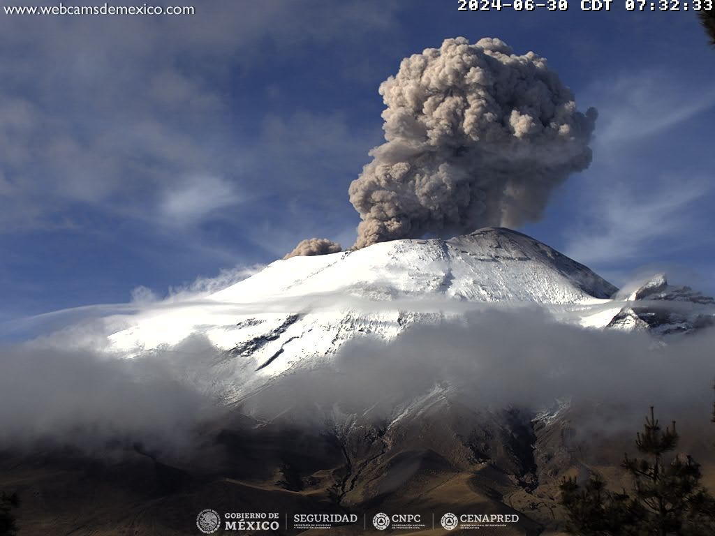
The Popocatépetl volcanic fire alert is in yellow phase 2.
The scenarios predicted for this phase are:
Some small to moderate explosions
Occurrence of tremors of varying amplitude
Light to moderate ash rains in the surrounding towns and in some more distant towns
Ejection of incandescent fragments within the 12-kilometer exclusion radius
The occurrence of lahars can be expected to descend into the ravines, due to the accumulation of ash on the slopes and its interaction with the rains expected in the coming weeks.
Possibility of pyroclastic flows not reaching the populations.
Source et photo ( 06/2024) : Cenapred.