September 19 , 2024 .
Hawaii , Kilauea :
Wednesday, September 18, 2024, 9:40 AM HST (Wednesday, September 18, 2024, 19:40 UTC)
19°25’16 » N 155°17’13 » W,
Summit Elevation 4091 ft (1247 m)
Current Volcano Alert Level: WATCH
Current Aviation Color Code: ORANGE
Activity Summary:
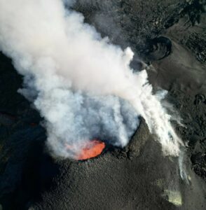
Kīlauea volcano continues to erupt in Hawai’i Volcanoes National Park from the new fissure vent that opened within Nāpau Crater yesterday, September 17, morning between 4:00 and 5:00 AM HST.
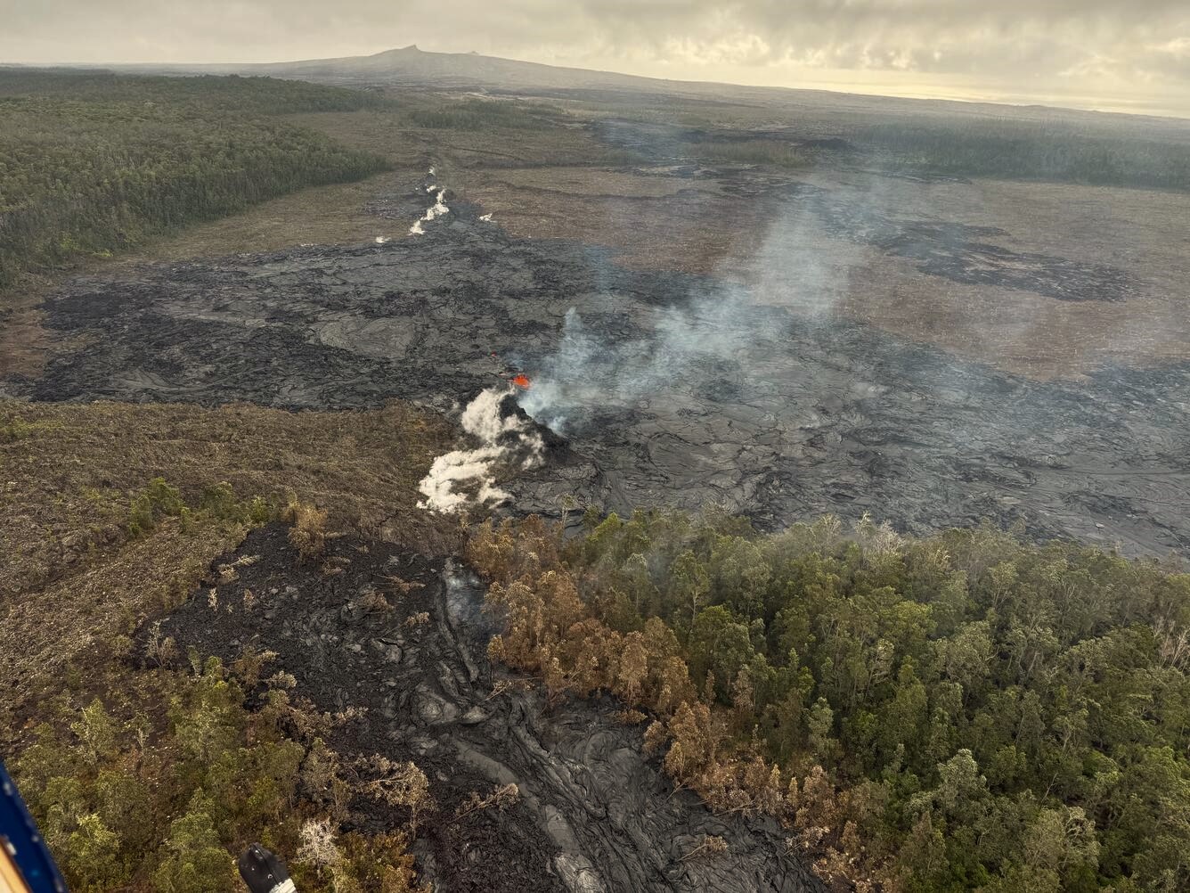
This photograph of Kīlauea’s ongoing middle East Rift Zone eruption was captured during a Hawaiian Volcano Observatory helicopter overflight during the morning of September 17, 2024. Geologists observed fountaining eruptive fissures and active lava flows on the floor of Nāpau Crater, just downrift (northeast) of the September 15 eruptive fissure. This south-facing view shows the current activity from the north side of Nāpau Crater.
Summit Observations:
Approximately 8 earthquakes were detected beneath the Kīlauea summit region over the past 24 hours, at depths of 1–3 km (0.6–1.9 mi) below the ground surface, and with magnitudes of 2 or less. The summit tiltmeter at Sandhill continues to record deflation, while the tiltmeter at Uēkahuna has shown little deflation since noon yesterday. This pattern suggests that only the deeper southern summit magma body is now supplying magma to the middle East Rift Zone. The most recent measurement of SO2 emission rate at the summit was 60 tonnes per day on September 17, 2024.
Rift Zone Observations:
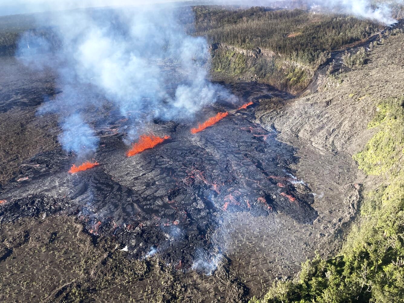
This morning, only the vents near the western end of the Nāpau fissure appear to have remained active overnight. At the time of this notice, fountaining could not be observed on the S2cam due to thick fume in Nāpau Crater. The fissure system in Nāpau is about 0.5 km long (.3 mi) and cuts east-west across the northern crater floor. The fissure opened just west of Nāpau early on the morning of September 17 and propagated eastward as the eruption progressed. Approximately 25-30% of Nāpau Crater floor has been covered by lava, which is confined to the crater.
During a USGS Hawaiian Volcano Observatory surveillance flyby on the morning of September 18, geologists observed very little activity at Kīlauea’s Middle East Rift Zone eruption site in Nāpau Crater. One vent was active with weak low-lying fountaining in a tiny lava basin, and much of the flow field was no longer active, although there was residual seepage on one margin of the flow field. A new small block of lava had formed at the western end of the fissure system since yesterday morning’s flyby, but it was inactive during this morning’s flyby.
Shallow earthquakes continue to be low in the MERZ with about 60 in the past 24 hours. Most of these were to the west and northwest of Nāpau Crater. Tiltmeters in the MERZ continue to show no significant changes. However, daily position solutions from GPS instruments have shown displacements of over 20 cm (8 inches) for several stations in the MERZ. The largest displacement is for station MKAI, just downslope of Makaopuhi Crater, which has experienced 54 cm (1.8 feet) of south-southwest motion since September 14. The combination of large GPS displacements and modest tilt rates suggests that much of the deformation is the result of magma entering a storage region several kilometers (1-2 miles) below the surface.
Sulfur Dioxide (SO2) emission rates measured yesterday, September 17, were 12,000 tonnes per day in the morning and dropped to 3,700 tonnes per day in the afternoon. This may reflect a decrease in effusion rate or be the result of the two easternmost fissure segments becoming less active late yesterday morning leaving only the westernmost vents active.
Wednesday, September 18, 2024, 4:17 PM HST (Thursday, September 19, 2024, 02:17 UTC)
Activity Summary:
The eruption near Nāpau Crater in Hawaiʻi Volcanoes National Park continues. Webcam and GOES satellite thermal imagery show that eruptive activity within Nāpau Crater, which had been waning throughout the day, has likely ceased while eruptive activity on the west edge of Nāpau Crater appears to have restarted at approximately 3:15 p.m. HST. Lava is currently cascading into Nāpau Crater on the northwest rim, visible in the S2cam. There is no immediate threat to life or infrastructure. The Volcano Alert Level/Aviation Color Code remains at WATCH/ORANGE. All current and recent activity is within Hawaiʻi Volcanoes National Park. No changes have been detected in the lower East Rift Zone or Southwest Rift Zone.
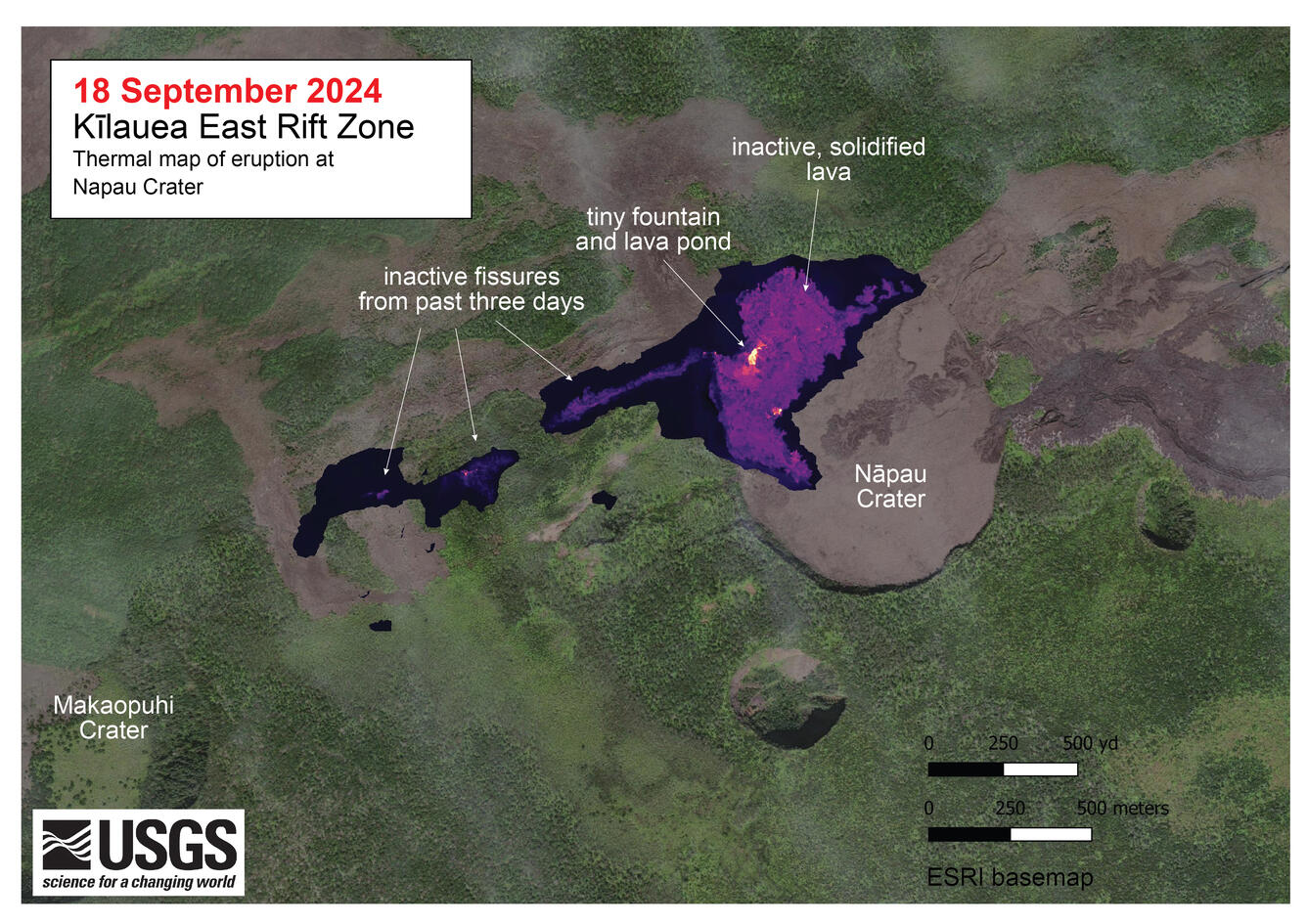
A helicopter overflight on September 18, 2024, allowed for aerial visual and thermal imagery to be collected at the middle East Rift Zone eruption site on Kīlauea. The eruptive activity continues with a single low fountain active within Nāpau Crater and much of the flow field on the crater floor stagnant. The scale of the thermal map ranges from blue to red, with blue colors indicative of cooler temperatures and red colors indicative of warmer temperatures.
Current eruptive activity began with a small eruption that occurred on September 15, 2024, on a remote section of the middle East Rift Zone in Hawaiʻi Volcanoes National Park, just west of Nāpau Crater.
HVO is continuing to closely monitor the middle East Rift Zone and is in contact with Hawai‘i Volcanoes National Park and the Hawai‘i County Civil Defense Agency. Temporary closures have been implemented as a result of this elevated activity.
Source : HVO
Photos : USGS / A. Ellis , USGS / M. Patrick , USGS.
Philippines , Kanlaon :
PHIVOLCS reported continuing unrest at Kanlaon during 11-17 September, characterized by increased seismicity and sulfur dioxide emissions. Sulfur dioxide emissions reached a record high on 11 September, averaging 11,556 tonnes/day (t/d), before decreasing slightly to 10,880 t/d on 12 September; emissions were not reported the rest of the week. The number of volcanic earthquakes detected by the seismic network was 337 during 10-11 September and 79 recorded during 11-12 September. The daily number fluctuated from 2 to 32 on the other days.
Weather clouds obscured views of the summit during the second half of the week. The Alert Level remained at 2 (on a scale of 0-5) and PHIVOLCS reminded the public to remain outside of the 4-km-radius Permanent Danger Zone and warned pilots not to fly close to the volcano. According to a Disaster Response Operations Monitoring and Information Center (DROMIC) report there were a total of 2,298 people in evacuation centers as of 16 September.
Sources: Philippine Institute of Volcanology and Seismology (PHIVOLCS), Disaster Response Operations Monitoring and Information Center (DROMIC) , GVP.
Photo : Vajiramandravi
Democratic Republic of Congo , Nyamuragira :
Satellite images from 13 and 18 September indicated continuing activity at Nyamuragira. The end of the NNW lava flow was about 7.6 km from the crater rim based on a 13 September satellite image and had advanced a short distance by 18 September. Lava had branched from the flow in an area about 1.3 km upslope from the end of the flow and traveled about 1.6 km NE. Lava flows that had breached the NNW crater rim traveled W and SW. The farthest end of the W flow was about 5 km from the crater rim and the end of the SW flow was about 3 km from the crater rim. Small thermal anomalies were visible near the ends of the NNW flow and in areas along the W and WSW flows. A larger thermal anomaly was present the part of the eastern crater floor. An 18 September image showed that the thermal anomaly in the main crater had shifted to the NW part of the crater. Scattered thermal anomalies on the flow fields indicated breakouts in areas along the margins of the NNW, W, and SW. Weather clouds slightly obscured the crater and flow field in the 13 September image but obscured most of the flow field and part of the crater in the 18 September image.
Lava flows from historical eruptions blanket the NW flank of Nyamuragira volcano. Lava flows issuing from radial fissures surround vegetated kipukas. Several major NW-flank eruptions took place in the late-20th century, producing lava flows that reached as far as about 20 km from the summit caldera.
Africa’s most active volcano, Nyamuragira, is a large, potassium-rich basaltic shield volcano located approximately 25 km north of Lake Kivu. Also known as Nyamulagira, it has generated massive lava flows that cover 1,500 km2 of the western branch of the East African Rift. The broad, low-angle shield volcano contrasts dramatically with the steep-sided Nyiragongo adjacent to the southwest. The summit is truncated by a small 2 x 2.3 km caldera with walls up to approximately 100 m high. Historical eruptions have occurred within the summit caldera, as well as from numerous fissures and cinder cones on the flanks. A lava lake in the summit crater, active since at least 1921, drained in 1938 during a major flank eruption. Historic lava flows extend down its flanks more than 30 km from the summit, as far as Lake Kivu.
Source : Copernicus , GVP.
Photo : Simon Carn, 2004 (TOMS Volcanic Emissions Group, University of Maryland, Baltimore County).
Colombia , Puracé – Chaîne volcanique Los Coconucos :
Popayán, September 17, 2024, 3:00 p.m.
From the monitoring of the activity of the Puracé volcano – Los Coconucos volcanic chain, the Colombian Geological Survey (SGC), an entity attached to the Ministry of Mines and Energy, reports that:
During the week of September 10 to 16, the seismic activity associated with fluid dynamics inside the volcano showed a significant increase in the number of events compared to the previous week. This seismicity, corresponding to Long Period events (LP type) and volcanic tremors (TR type), maintained low energy levels and was located under the Puracé volcano at depths of less than 1 km. Seismicity related to rock fracturing (VT type) also recorded low energy contributions and was concentrated near the crater of the Puracé volcano, with depths not exceeding 3 km.
In addition, the slow deformation process that began in April 2022 on the Puracé volcano continues to be recorded. On the other hand, the monitoring of volcanic gases, electromagnetic fields and acoustic sensors does not show significant variations. As for the images captured by the installed cameras, it is observed that high degassing continues inside the crater of the Puracé volcano and from the lateral fumarole.
Based on the above, the SGC recommends closely monitoring the evolution of volcanic activity through weekly bulletins and other information published in official channels, as well as following the instructions of local, departmental authorities and the National Disaster Risk Management Unit (UNGRD).
The alert status for volcanic activity remains in yellow alert status: active volcano with changes in the behavior of the base level of the monitored parameters and other manifestations.
Source et photo : SGC
Japan , Suwanosejima :
JMA reported that eruptive activity at Suwanosejima’s Ontake Crater continued during 9-16 September and crater incandescence was observed nightly in webcam images. Explosions were recorded at 1728 on 9 September, at 1001 on 11 September, at 1345 on 12 September, and at 1948 on 13 September. Volcanic plumes generated by the explosions rose as high as 800 m above the crater rim. The Alert Level remained at 2 (on a 5-level scale) and the public was warned to stay at least 1.5 km away from the crater.
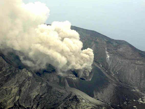
The 8-km-long island of Suwanosejima in the northern Ryukyu Islands consists of an andesitic stratovolcano with two active summit craters. The summit is truncated by a large breached crater extending to the sea on the E flank that was formed by edifice collapse. One of Japan’s most frequently active volcanoes, it was in a state of intermittent Strombolian activity from Otake, the NE summit crater, between 1949 and 1996, after which periods of inactivity lengthened. The largest recorded eruption took place in 1813-14, when thick scoria deposits covered residential areas, and the SW crater produced two lava flows that reached the western coast. At the end of the eruption the summit of Otake collapsed, forming a large debris avalanche and creating an open collapse scarp extending to the eastern coast. The island remained uninhabited for about 70 years after the 1813-1814 eruption. Lava flows reached the eastern coast of the island in 1884. Only about 50 people live on the island.
Sources :Japan Meteorological Agency (JMA) , GVP.
Photo : JMA ( Taken from a helicopter of Kagoshima Prefecture , 05/2001) .